Training Log Archive: PGIn the 31 days ending May 31, 2010:
| |||||||||||||||||||||||||||||||||||||||||||||||||||||||||||||||||||||||||||||||||||||||||||||||||||||||||
| « | » |
| » now | ||||||||||||||||||||||||||||||||||||||||||
| Sa | Su | Mo | Tu | We | Th | Fr | Sa | Su | Mo | Tu | We | Th | Fr | Sa | Su | Mo | Tu | We | Th | Fr | Sa | Su | Mo | Tu | We | Th | Fr | Sa | Su | Mo | |||||||||||||||
Monday May 31, 2010 #
Note
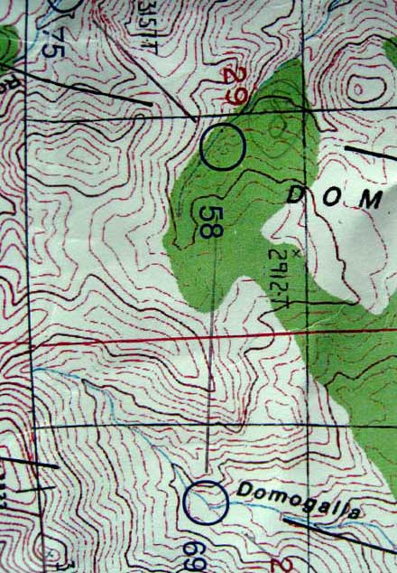
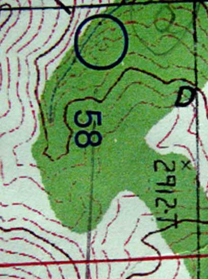
But here's a sample, the one control we had trouble with, going to 58 from 69, sometime around 2 am. One of several night legs that we had planned to test our night O'.
(As I've done more rogaines, the night part has gone from being terrifying, to scary, to anxious, to maybe sort of fun, to more interesting than the day parts, to the best part of the rogaine. We deliberately didn't try to find easier legs, i.e. more road sections or more open country, for the night, in fact we checked our planned route as an afterthought just to make sure there would be some challenging night sections.)
The plan here was a bit of a right swing to avoid going over the top of the ridge, then a challenging diagonal approach (generally harder than "with the grain" or "across the grain" approaches) across some mottled terrain.
The problem was we couldn't read the map in the green section (green was scattered trees, not thick vegetation), the contours were either faint or completely washed out. Plus, of course, with 40-foot contours, there is always more happening than the map shows, more knolls, more reentrants, etc.
Kept going, on a bearing, nothing in the terrain made much sense. Barb spotted a nice knoll off to our left, we checked it out, nothing. In retrospect, I think it was on the spur just south of the "5" in "58."
The problem with veering off to something you think might be the right spot, and then it isn't, is that your sense of where you really are is now quite bad.
So back to a skill I almost never use (because I usually know where I am), back bearings. I could pick out the profile of the hill lying grid south of 58, and that confirmed we were too far east, hadn't gone far enough. So we headed west a bit, checked the horizon again, not quite enough, went further, and then the Tesla lit up the control from about 75 meters away. Very fine.
One more thing for Barb's rogaine committee to think about -- map printing. Just because the maps are old school for accuracy doesn't mean they have to be old school for printing. Here's the area around 58 blown up --
hike 43:30 [0] 1.39 mi (31:18 / mi) +161ft 28:12 / mi
slept:9.0 shoes: saloman
It took a bit to get there as the Google recommended route did not considered road conditions...

... so we made a wise retreat and tried a different approach and got there successfully. Very beautiful country...

Plus a hillside that was just like some northern Scandinavian forests, bare rock and moss and the very occasional tree, except this one needs to be tilted quite severely before anyone but Ross can run up it...

The soak was great, but the legs seem to be getting sorer as the day goes on. But no blisters at least.
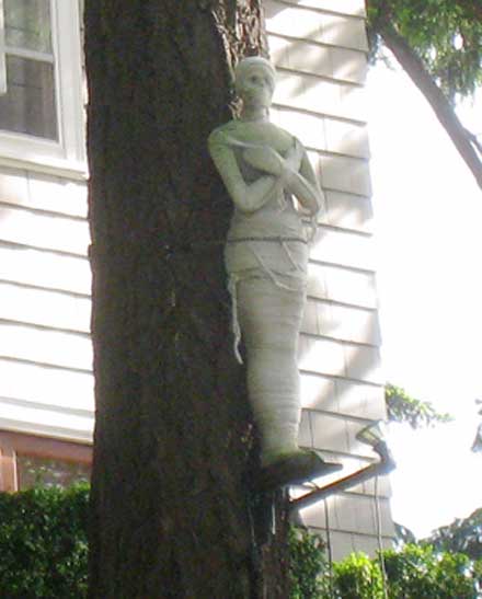
Then a drive back to Portland, a quick perusal of one of the neighborhoods up on the hill just west of downtown where every home was posh but only one seemed to have a mummy out front.
And then to the airport and a wait for the red-eye. But they have free WiFi! :-)
Sunday May 30, 2010 #
rogaining 23:45:00 [1]
slept:0.0 shoes: saloman
Strategic plan -- excellent. To the extent that we gave any consideration to what part of the course we might be doing at night, the plan was to make sure those legs were as difficult as possible. :-)
Navigating -- excellent. One minor fumble at night, corrected well. It does make it a lot easier when all the controls are in exactly the right place.
Physically -- terrible. Struggled up many a hill. No energy. Not so bad the last 6 hours, perhaps because at some point around dawn Barb offered to carry my pack. I declined, we all have our pride, and I think it spurred me to put out a little more.
Equipment -- wonderful. The Tesla was magnificent.
Ailments -- the usual 50-100 falls, so a little battered. But nothing serious. And no blisters. The feet/heels hurt most of the time.
Results -- Not sure. Maximum was about 3200 points (58 controls). One men's team got them all in 21+ hours. Second (Vladimir and ?) and third got 3100+. We had 2550, got beat by one mixed team and an unknown number of men's teams. Seemed excellent given how slowly we were going.
Team karma -- excellent. One of our better ones, maybe the best.
Saturday May 29, 2010 #
Note
Heavy rain driving up here but should be fine for the rogaine, not too hot, not too cold. We'll see if we have our act together or not.
Friday May 28, 2010 #
Note
I chatted up the third person in the row as we were waiting to get off the plane. Middle-aged woman, lived in Boston, short trip to Iowa for a relative's graduation.
And then she said, "I heard you talking about orienteering." She likes going out in the woods, sometimes gets lost, would like to try O', never has. Life is so busy.
Gave her some encouragement and the NEOC web address.
How do you get someone to take the first step?
Note
Quite a productive layover (in the sense of avoiding future spitting matches)!
Wednesday May 26, 2010 #
Note
From 1979, the original Billygoat, course set by Fred Pilon, won by Bob Lux.
.jpg)
From 1986, memorable for the time John Rogers arrived by helicopter (seriously). It was Mother's Day and all mothers who finished got roses. Looking at the map also bring back memories of something that many orienteers may not be familiar with, namely the old-fashioned way of printing courses on maps, one at a time, first setting up all the circles and lines and numbers on the sticky pad, then for each map pressing first into the big ink pad and then onto the map, all the while saying the mantra, "Never again." :-)
.jpg)
From 2004, course by Will Hawkins, map now at 1:10,000.
.jpg)
biking 1:12:08 19.87 mi (3:38 / mi) +384ft 3:34 / mi
ahr:134 max:156 weight:138.5lbs
Wish I could say I amused myself, wish I could say I entertained myself, let's just say I passed the time pondering the dust-up over posting maps and other related issues. Perhaps the phrase "All's well that ends well" will apply. We will see.
Meanwhile, time to get my rogaine stuff together. Big Muddy is this weekend and I am woefully unprepared.
Monday May 24, 2010 #
Note
-- She arrived Thursday early afternoon, and right away we took care of one of the reasons for the trip, a very little bit of tax consulting.
-- A training session, the traditional up to the power line and back.
-- A late evening trip out to the film house, when we normally would be falling asleep, with popcorn for one of us.
-- A Friday morning trip to the zip lines, her and Gail only, I was too chicken.
-- Another training session, up to the power line (and a little farther) and back.
-- A trip to Vermont, her first ever, for a Thai dinner, also her first ever.
-- A couple hours of training at Norwottuck Saturday morning, followed immediately, and I mean immediately, by a trip to McDonalds for a double cheeseburger (I was driving, and I got my orders), followed by a trip to the supermarket to lay in supplies for dinner (including two boxes of a very rich fudge brownie mix), followed by a trip to the bookstore for something to read, followed by various preparations for dinner, and the arrival of Peter Goodwin, and Alex Jospe, and Ali, and SGB, and Presto, the best behaved dog ever. And a very fine evening....
-- And then the Billygoat, and she makes it around successfully, and then goes to work on the e-punch data for a bit while I go fetch a few controls, and then she loads it all on her computer and we head home, with, of course, a stop at the Northampton McDonalds for another double cheeseburger, where I'm having such a fine time chatting up the girl at the first window where we're paying that when we're done there I'm almost out of the lot before Valerie yells to remind me that it might be a good idea to go back to the second window and actually get the food we've paid for.
-- And then she works until after midnight trying to sort out the data, wonder woman that she is.
-- And then up early this morning to head off to the airport for her flight back to DC.
I was very tired today, I thought from yesterday's Billygoat. Though, on reflection, it may just be from trying to keep up with Valerie. She is amazing, and fabulous.
Sunday May 23, 2010 #
orienteering 2:09:04 7.68 mi (16:48 / mi)
ahr:151 max:175 shoes: x-talon 212 #2
And my run? The verdict is in and it only takes one word -- fabulous. :-)
No, seriously, it was better than I had any reason to expect. Virtually no mistakes. Tired, of course, but not as bad as I anticipated (we did have 800m of drop). And a placing high enough that, well, if Joe Brautigam, next year's head goat, designs a course with a reasonable number of controls, one of them near the end may have PG on it. (There was a PG control today, though that was a salute to Peter Grollman.)
Nice win by Boris, nipping Ross by 5 seconds as they took different forks right at the end, first win by Boris after several runner-ups, though disappointing I'm sure for Ross. Samantha led the women again, with an out-of-retirement Hilary close behind. Big Eddie was first old men, Tracy Olafsen frst of the old ladies, Carl Underwood and Meg Parson first juniors, Luke Lyons the youngest ever BG finisher at age 8, one of 6 members of the Lyons family to finish the course.
Thanks again to Phil. It's a good bit of work putting this on, and then you have to hope that no controls get taken and no one gets badly hurt, so it's a stressful weekend. But he did an A+ job.
The course.
.jpg)
My routes. Skipped #15 (had been thinking of skipping 7, but decided 15 was a better choice), took the right fork at the end.
QR.jpg)
Saturday May 22, 2010 #
orienteering 2:41:20 5.53 mi (29:10 / mi)
ahr:98 max:126 shoes: saloman
Hanging streamers can be interesting. It's one thing when you are course setting and you go out to fieldcheck the points -- if something doesn't seem right, or the feature is not sufficiently distinct, then you just don't use it. But when the course is already determined, then you just have to hang it in the right place, even if it is bogus. Had just one really bogus one today, so not so bad.
One thing you notice going slowly is how the map is. Norwottuck has the usual stuff you would see on almost any map -- you could quibble with the green, or the marshes, or the rocks, or the contours -- but mostly that stuff is within reasonable tolerances. The one thing that is really insufficient is the trail network, mostly the bike trails that have been added over the years (and mostly were being added during and just after Clint was doing the last update, so I'm definitely not picking on him). For anyone one using the map who has not orienteered too much, I would guess it would be a real problem, since trails are one of the main things you rely on.
Today's stroll.
QR.jpg)
Friday May 21, 2010 #
Note
The event was the relay in the 1978 World Championships. I was running first leg for the USA. If I remember correctly, besides the obvious motivation to beat as many other countries as possible, there was also the motivation to have a better time -- even though our courses were forked, they were similar -- than the other members of the USA team. :-)
Here's my map. And the reason I mention it is that on the way from 1 to 2, I went to the right of the bunch of cliffs, and then after a bit I happened to notice that I was right on course to spike #9. I don't know what I thought at the moment of discovery -- yes, O' truly is "discovery," though this may not be the intended situation -- nor do I remember what I may have said to myself, since I'm pretty sure that at that long ago time WTF has not yet been invented.
.jpg)
I believe I corrected rather well, moved on to 2 without much loss of time, and in fact moved on around the course with very little loss of time, 77 minutes for a course that was about 10 km (results). The other thing I remember was running all the way up the hill on the way to 11, saying over and over, got to beat **, where ** was another member of our men's team. You get motivation where you can.
Anyway, if I am worried about the deterioration of my mental skills, then this is good news, because I have been doing this particular fuck-up now for over 30 years, and therefore I am no worse than ever. Though I suppose it could also be bad news, because if I have been doing this particular fuck-up for over 30 years, then it is pretty likely going to happen again. I can hardly wait.
Note
And the following e-mail arrives this morning from Joanne Sankus --
Hi Peter,
Ross had requested permission to use NEOC maps for the training at Norwottuck on Saturday, presumably to make copies for anyone without an old Norwottuck map in their pile. (That's that old copyright problem.) As you are probably aware, small groups of less than 25 do not need a permit to use DCR property. Since the training has already been advertised on Attackpoint, it brings up the concern of how many people will actually show up. As a NEOC member I know you are invested in not jeopardizing the club's land use privileges, and DCR property makes up over half of our most useful maps.
What is your take on how these training events are seen (or not seen) by the rangers? Granted this is not a bunch of rowdies having fun at a park, but giving permission to use a NEOC map does infer responsibility by the club, even if "possession of this map does not constitute permission by the landowners".
Not a lot of fun when you have to think in these terms :). But that's part of the job description. Was there a rumor about you running for a club board seat ? :)
Joanne
=====================
A valid point. But think of the e-mail that could have been written --
Hi Peter,
I hear there will be training at Norwottuck on Saturday. Sounds like fun. Wish I could make it. Have a great time!
Joanne
PS. I'm sure you know, but groups of 25 or more require a permit. I'm guessing you'll be well below that number, given that most people will be saving their energy for Sunday.
=====================
And, no, I sure don't plan to run for the NEOC board.
biking 39:38 11.3 mi (3:30 / mi) +272ft 3:26 / mi
ahr:140 max:165 weight:140lbs
Thursday May 20, 2010 #
Note
And Banksy's website.
biking 47:17 13.58 mi (3:29 / mi) +325ft 3:24 / mi
ahr:139 max:160
Monday May 17, 2010 #
Note
Note
A depressing though probably realistic thought -- if I hit my D1 the way I orienteer, the upside is that I would almost never miss the fairway. On the other hand, I would occasionally head to the wrong green, or skip a hole, or play the holes out of order. Oh, and the ball wouldn't go more than about 120 yards....
Sunday May 16, 2010 #
orienteering 1:32:14 6.19 mi (14:54 / mi) +833ft 13:13 / mi
ahr:149 max:177 shoes: x-talon 212 #2
Course.
.jpg)
I think the executive summary of the day would be that things improved noticeably after about 10:15 am. Which just happens to coincide with the time I finished the course.
I am no longer able to do any sort of justice to a course like this. That's just the simple truth. Can't deal with the rocks, or the laurel, or the blueberry-filled "white" forest, or the hills. Fell down a lot of times. Walked a whole lot. Got very tired. And I suppose it could have been a lot worse, since I did spike most of the controls. But it was still pretty feeble.
On the plus side, it should move me closer to being able to take part in the new OUSA program -- which hopefully will be up and running by then -- to offer to ancient and decrepit male orienteers the shadowing services of cute young female orienteers, just to make sure the organizers don't have to launch search operations when we don't come back. Such a service could even be a team fundraiser....
Injury report:
-- weirdly sprained left ankle, rolled it during the middle on Saturday morning, some sharp pains but zero swelling or discoloration, ran a little gingerly on Sunday.
-- lost a lot of skin and a little flesh off my right thumb (kept having to wipe the blood off the map case so I could see the map). This will heal, but may be a bit unpleasant during possible biking or rogaine practice the next few days.
-- the heels are still sore, but not significantly worse.
-- mentally appalled.
My navigating was mostly adequate but no more. Got helped into #1 by Kris. My route to 5 is absurd, mostly because it was only at the last moment that I realized I was heading to 7. And the last part of 15, on which leg I was trying to see how accurate I could be on the first part just going due north, at the end my map reading was terrible, didn't place myself correctly crossing the stream and trail. No big deal, corrected OK, but I thought I was better than that.
My routes.
QR.jpg)
Note
From a purely competitive point of view, and no matter and old and slow and mellow I get, a bit of competitiveness still lingers, I couldn't help but smile a little when I looked at results later and saw that, compared to my 92:14, Carl had done 92:16, Jeff 92:39, and Glen 93:29. We'll just ignore the fact that Pavlina womped me by 15 minutes.
And then I hung out by the finish to watch the Trials folks. And then we did our Review Panel stuff and announced the WOC Team. And then talked to Ross about possible CSU training on Saturday out here. And had a very pleasant time hanging out. And a relaxed drive home late in the day, even stopped on the way to post the team selection if it hadn't already been done, but Boris had taken care of that. I suppose I could get one of those fancy phones, but I'm not quite there yet....
Saturday May 15, 2010 #
orienteering 36:45 2.26 mi (16:16 / mi) +279ft 14:34 / mi
ahr:156 max:172 weight:140lbs
Today's middle course.
And my route.
orienteering 14:01 1.46 mi (9:36 / mi) +105ft 8:59 / mi
ahr:169 max:178 shoes: x-talon 212 #2
Nominal distance was 2.1k, 45m climb.
Today's sprint course.
And my my route.
Thursday May 13, 2010 #
Note
I had plenty of time last weekend to observe folks. And one thing was quite amazing -- how they dealt with getting their clues two minutes before their start.
A few didn't take them at all (the clues were also on the map), but these were generally less competitive folks.
Of those that took them, maybe 1/4 applied tape to them, either to protect the clues or to fasten them onto their body somehow, or both. I didn't see a single version of this process that I liked. Yes, I know some folks are probably quite attached to what they do, but the tape operation looked stressed, rushed, and if you do it a few times, liable to be screwed up. None of which is what you want as the clock is ticking down.
The rest had some sort of carrier -- slip the clues in it, attach it to your forearm (usually), and you're good to go. Seems fine.
Except here the variety of carrying devices was also amazing, and certainly seemed to me in a lot of cases to be proof of the well-known frugality among orienteers. I'd guess half of the carriers ought to be trashed -- things are frayed, things are torn, the plastic is shot. The struggles I saw as people tried to insert the clues and then fasten the devices to their arms, well, here too it look stressed, rushed, and liable to be screwed up.
You ought to be able to do the whole thing in 20 seconds, absolute max 30. Under any conditions. Cold, or rain, or wind, or hot and sweaty, or any combination thereof. With a thumb compass on one hand and a dibbler on the other.
You do practice this, right?
Yes, it's simple and it's trivial, but if you can't get this right....
Note
Sunday May 9, 2010 #
Note
Start operation went well, dealt with any problems smoothly. Nothing like having a good crew. And best as I could tell, the whole meet went really well. One thing I'm sure of, WCOC is a great club.
Note
And meanwhile, an old orienteering friend had ambled out to the start, he wasn't competing, could he ask me a question or two.
It seems he is where I was about 2 years ago, having to deal with prostate cancer. Lots of questions in fact. We took a long slow walk back, a very frank discussion including stuff that guys don't normally talk about. He is pretty stressed, as expected. He too has a journey ahead that will not be pleasant. But I think this helped a little.
Driving home, I realized I forgot to tell him one thing, that there has been one unexpectedly positive result of my journey, that I now appreciate the good things in life and don't sweat the bad stuff as much. And that is not trivial.
Saturday May 8, 2010 #
Note
A little rough around the edges, the rain didn't help, but no problems.
Stopped by at the DeWitts in late afternoon to do a little gear organizing for tomorrow. Lots of folks there. And it all reminded me of what a fine bunch of folks are in WCOC. Such a pleasure to be associated with. And then you add Valerie and Sandy to the mix. Very fine.
And then dinner with Judy and Jeff, and Rick and Linda and Lindsay, lots of good stories.
Have a few extra awards planned for tomorrow. All can be eaten or drunk.... :-)
Note
Friday May 7, 2010 #
Note
I ask this only because there is a widely held belief among practitioners of both sports that orienteering and golf are essentially the same thing. And today, for the first time in a few years, I had a golf lesson.
So the pro asked me what I was having trouble with. And I said, check my fundamentals (grip, stance, alignment, posture, etc.), something is screwed up and so nothing feels right.
So he had me hit a few balls, and in all honesty they weren't bad, better than my average effort recently, and then he showed me what I was really doing, and mainly my alignment was way off. And we spent ten minutes working on that (get aimed correctly, then straight back, straight forward is the mantra), and I was a new man. Off to play a few holes, it was a remarkable difference.
Of course alignment plays a major role in O'.
I remember a long, long time ago, when I was not so old and Peggy was just a young babe, and I was giving her an O ' lesson of sorts, and I thought it would be useful to check her alignment.
So the instructions to her were simple -- run due west. And just so I could tell how often she was looking at her compass, since I was running behind her, I told her to yell, "Beep," every time she looked at her compass.
And we started off. And I had quite deviously chosen as a starting point a spot where there was a fallen tree just to her west, so the first 10 or 20 yards had to be to the northwest. And then I figured she would correct back to due west.
But it never happened. She kept going merrily northwest, beeping quite frequently, until after about 150 yards I invoked the mercy rule and stopped her. I was also laughing too hard to keep going.
She obviously had an alignment problem. The compass was getting lined up to due west by bending the wrist a lot, not by turning the body. And the result was a fundamental skill in O' that she hadn't mastered. And this was a way to point that out, and therefore the first step to fixing it.
Do we ask ourselves how good our O' fundamentals are? And regularly get them checked?
biking 32:33 9.52 mi (3:25 / mi) +184ft 3:22 / mi
ahr:136 max:156 weight:139.5lbs
Thursday May 6, 2010 #
Note
The committee has recommended option D, with E and B as alternatives, giving the Board three to choose from. The vote is tentatively scheduled for Tuesday.
Will this finally settle it? One hopes.
Or will those unsatisfied press on? Will there be talk of rebellion. A new federation (just for the purpose of being able to have a different logo)?
You'd think we'd realize there are better things to spend our time on. Though this has been entertaining. And I have been very impressed by writings of a couple of younger members of USOF. Perhaps someone should be recruiting them for the Board?
biking 52:57 14.83 mi (3:34 / mi) +289ft 3:30 / mi
ahr:127 max:146 weight:139lbs
Very windy, out of the west, but it gets deflected by the hills and trees. Sometimes it feels like you're going into the wind most of the time. Today felt the opposite, had the wind with me a couple of times I didn't expect. Not that I'm complaining.
I've been thinking maybe I should do a longer ride, like a century, just for something different. The only organized one I've done (as opposed to just riding 100 miles on my own) was Mt. Greylock several years ago. That was a lot of work.
Hmm, maybe a different one, and less hilly, would make more sense.
But there does need to be some challenge. Otherwise, what's the point of doing it? And we have plenty of time to be sensible.
Wednesday May 5, 2010 #
biking 1:10:32 18.91 mi (3:44 / mi) +502ft 3:38 / mi
ahr:131 max:152 weight:140lbs
Not pushing the pace, as the heart rate would indicate.
I think the heels are slowly getting less bad. Might even have to start a little running before long. Meanwhile, the rogaine practice continues, with the most success (psychologically) coming from the O' equivalent of running as fast as you can and maybe you'll miss quite a lot but you'll have a few really good splits -- i.e. swing as hard as possible and then go and try and find it.
Tuesday May 4, 2010 #
Note
She also seemed to keep track of the different characters much better than I did, including several scruffy similar-looking guys doing all sorts of bad things. And on the way home, it was clear that she understood a lot more of the plot than I did.
Maybe if there ever is a DVD I can rent it, Gail says they often come with a sub-title option. I wouldn't know, never rented a DVD (or a VCR tape).
I think such ignorance of cultural icons is in my genes. I don't believe my mother has ever been to a McDonald's (or even know what that is), or has ever had a Coke. Some of us are just hard-wired to be out of touch.
On the other hand, I think I may actually have enjoyed the flick more than Gail did. A little hard to tell.
biking 1:18:10 20.68 mi (3:47 / mi) +732ft 3:39 / mi
ahr:137 max:157 weight:140lbs
Monday May 3, 2010 #
Note
I adjusted the color scale to a range of 6 to 14 min/km, and then it's actually quite interesting, because it gives me a pretty good view on how much walking I was doing. Basically anything from yellow to red is walking. And it seems like quite a lot.
A few notes --
2. I think my route was fine, especially taking it from above. No doubt at all where I was, until I got within 30 meters of it, standing on what seemed like a rock face, no control. The control was down one feature, what I was on was rocky ground.
3. So easy, if you read the map and take a look at your compass, but people missed it.
4. Too low at the end. Knew it, but took a while to adjust.
5. No good route, I think just going through the green was as good as anything else. It was downhill but I was moving slowly, just shorts and a t-shirt, didn't want to trash myself too badly.
8. While I was in complete control approaching the pit, I'd forgotten to remember which way I wanted to leave, so that part was quite sloppy.
9. Ran right by it, stopped maybe 30 meters later. I knew it was supposed to be on the NE side of the boulder. I could see the NE side of any possible boulder, and no control. Stood there for a while trying to figure it out, when another runner appeared at the boulder I'd passed, and there it was, in sight all the time. My eyes are not getting better.
10. The one really depressing leg, at least as far as how I did it. I used to be able to do this stuff easily. Plan was simple, left edge of the knoll, then NNE to the spur, then the rest should be obvious. But the contours just seemed off, and I wasn't sure, so I stopped, and moved a little, and stopped, and moved a little, and again and again and again. And eventually nailed the control, but just so incredible slow. Are my map reading skills disappearing too?
One unforeseen consequence -- or perhaps just a coincidence -- of wearing just shorts and a t-shirt (and no gaiters) was that I don't think I fell down once. A reason might be that I was trying to avoid any low vegetation to avoid getting scratched up, which meant I was generally going where I could see the footing better, or going slower and more carefully when I couldn't. The only time I fell all weekend was on the sprint, running across a bit of bare rock, went to look at my map and went splat. That had nothing to do with wearing shorts.
So while my legs are a little scratched today, general soreness is a good bit less than expected.
Note
The bad news was how her orienteering seems to lack discipline -- things that she should be doing in certain situations, and that when armchair orienteering she can see she should be doing, don't get done in the heat of battle. So she is much much sloppier than she should be.
The good news is that that means there's much more room for improvement. :-)
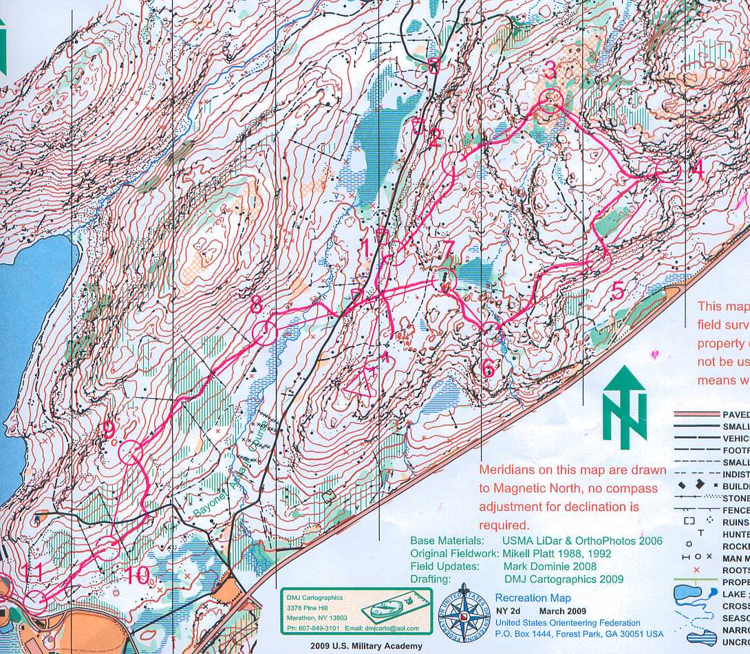
Sunday May 2, 2010 #
orienteering 58:00 5.91 km (9:48 / km) +499ft 8:41 / km
ahr:150 max:169 shoes: x-talon 212 #2
Green Y course, M60, straight-line distance was 5.2 km, advertised climb 195m.
A similar "run" to yesterday morning, a couple of poor controls, maybe a couple of minutes lost, and a lot of moving in slow motion, but still basically a good outing because I was pretty close to what I was capable of under the present circumstances. Which is all you can ask for.
I'll put my routes up in a while.
But first just something about the cadets that organized the weekend -- they did a great job. And you can't help but be impressed by all of them, they seem to be smart, competent, courteous, pleasant, and also, though they kept it hiding under the surface, tough as nails. Just a pleasure throughout the weekend to interact with them.
I also had a chance over to weekend to see an old friend, someone I hadn't seen for a while, Bud Fish. Bud is the guy that got the orienteering program going at West Point.
The first couple of times I orienteered at West Point were in the mid-70s. The maps were the military version of USGS. I have two recollections. One year the obvious route on one leg of the blue course was around the south end of a pond through a short section of crossable marsh. The marsh turned out to be crossable as long as you could swim. After I had gotten across I noticed a guy on the shore wringing out his jeans. Such were the O' fashions of the time.
The other memory was on the area we used today, again a leg on the blue course. Not many running the course, I think I was the first one out, and as I was running up a jeep road I noticed a van parked alongside it. And as I got closer I saw the sliding door on the van was open, as it was a warm morning. And as I got even with it I couldn't help but notice that inside the van a guy and a girl were having at it. I am not making this up.
Reports from later runners indicated the van was gone by the time they got there.
I'm sure the O' fashions have changed in the last 35 years. My guess is that this other custom endures....
Anyway, as part of getting the orienteering program at West Point established in such a solid way that it has endured for nearly 4 decades, Bud did something that at the time I thought was nuts -- he got West Point mapped. Mapped to the current O' standards of the time. I thought the place was too hilly and too rocky. Well, it is still hilly and rocky, and will always be hilly and rocky, but over the years it has been the site of some excellent orienteering.
Thanks to Bud.
He got a good base map from Sweden, it covered the area from Round Pond down to Bull Pond, and got Göran Öhlund, a world champion (relay) from Sweden to come over and map the north section of the area, around Round Pond.
Bud called me up when Göran arrived, got me to come down to go out in the woods for a day to watch Göran work. We drove out to one side of the area, parked the car, and headed up a dirt road to the interior of the map. His legs were twice as long as mine. I didn't have to run to keep up but it was close. He was looking left and right, occasionally saying things like, "I'll take this," or "I'll take that."
After we had gone maybe a quarter mile up this hill he stopped to look around, his map board in one hand, pencil in the other. I glanced at what he was doing, and only then did I realized he had already mapped the section we had been through, as far as he could see in each direction.
Welcome to the big leagues.
And then Bud talked me into coming down to West Point for a couple of weeks to map the south section around Bull Pond. And then Popoloppen in the middle got mapped. And they were all far from perfect maps, and certainly far different from maps of today. But they were real O' maps.
And Bud got it started. And that should not be forgotten.
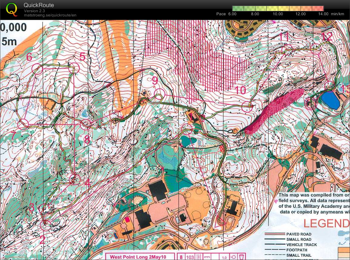
Saturday May 1, 2010 #
orienteering 36:50 [3] 3.5 km (10:31 / km)
weight:139.5lbs shoes: x-talon 212 #2
Hadn't run in 3 weeks (other then one day when I left a wedge at the first tee, didn't discover it until I needed it at the first green, and had to run back and get it), but things were not so bad as I feared. Heels moderately sore, energy moderately bad, skills middling. I did somehow manage to arrive with my 305 fully discharged instead of fully charged, so no data.
Ran in shorts. Definitely more pleasant than long pants. And an excuse to go very slowing weaving through the barberry to avoid getting torn up. Just one small cut.
I really have to look into getting a magnifier. I can read the map fine if it is still, but only poorly when I am running. A couple of mistakes today, maybe a minute to two total, would have been easily avoidable with better map reading.
Final time was surprisingly competitive. The others must be getting old.
Read in the meet notes about the new, more detailed, mapping standard at West Point. I remember saying to myself partway around the course, "Peter, just because the map is new, that doesn't mean it is any good."
To apologize for that snide comment, let me also add that the cadets seemed to do an awful lot of good work for this event. Just really nicely organized. In every respect.
My course. Not a very good photo (it's almost all white woods, not yellow), I'll do a proper scan when I get home.
.jpg)
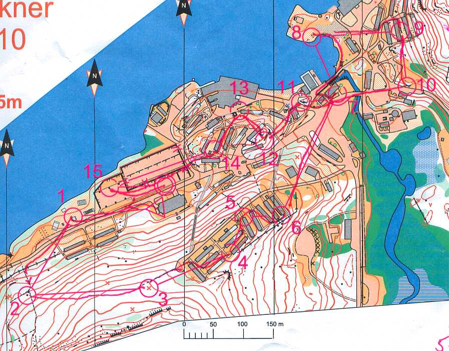
orienteering 14:22 [4] 2.1 km (6:50 / km)
shoes: x-talon 212 #2
Had a pretty good run, just the aforementioned problem reading the map on the run, I get some info just not enough. But no mistakes of any significance and a decent effort under the circumstances. I did have the advantage of having set courses here before, but much of the time the orienteering was pretty easy, just count the buildings and keep your eyes open.
Were I running faster it would be more difficult, the main challenge under the circumstances being to make sure I went to all the controls and in the right order. Which I managed to do.
A good result.
And then totally wasted afterwards, napped a little before dinner, still wasted. Tomorrow may be a struggle....
My course, same disclaimer as above.
.jpg)