Training Log Archive: NadimIn the 1 days ending Aug 17, 2019:
| ||||||||||||||||||||||||||||||||||||||||
| « | » |
| » now | ||||
| Sa |
Saturday Aug 17, 2019 #
8 AM
Orienteering (Foot) 5:49:10 [3] 12.3 mi (28:23 / mi) +1582m 20:17 / mi
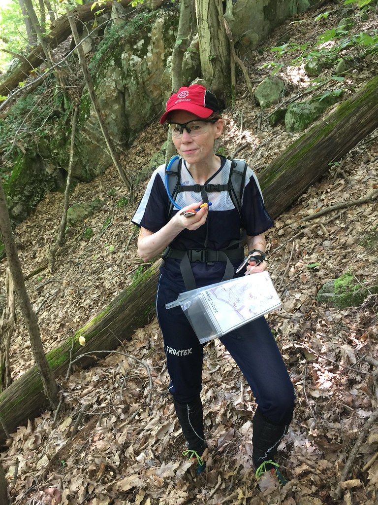
Summer Short Series: Michael Dickey setup a pretty nice 6 hour rogaine by making a map of Sugarloaf Mountain, at the SE end of Frederick County, MD; just over the line from Montgomery County. He must have put in a lot of time setting up the map--one of the joys of being retired. The contours were good, based on LiDAR; 5m interval. Many trails big and small were shown. He added additional useful terrain features such as cliffs, boulders, clearings and more. The scale was 1:15,000 and printed on two sides of 11"x17" paper.
We started at the Sugarloaf Mountain West View Parking Lot which is nealy on top of the mountain. Though I thought about it several times, I hadn't been there in decades. Peggy and I "ran" together. We spent most of the time walking but we did run where it was good enough to. QOC had evaluated this areas sometime before I joined the club, and had thought it to be too green. Many parts were just fine, even though we're in the midst of summer. Some areas were a little too steep, rocky, or had low vegetation (stilt grass, ferns, blueberries, mile-a-minute vine) including deadfall. We had the added difficulty of it being very humid. There was early fog while driving-in. The temperatures at the 8:30 start were a little above 70 F, and the expected high was to be 92 F.
Michael accurately set a lot of nice controls with appropriate point values. We took our controls in this order: 52 (2), 47 (2), 43 (1), 44 (4), 40 (3), 38 (4), 33 (2), 31 (3), 34 (2), 32 (3), 36 (3), 42 (2), 39 (1), 37 (3), 41 (3), 48 (1), 50 (2), 49 (3). Our point total without any bonus was thus 43. We probably got a point or so for turning in a Heineken beer bottle too. With the map on two side of a paper, Peggy and missed some better opportunities for points. At 47, we could have picked up 42, 36, and 35 for 9 points, instead of the 3 we got with 45 and 43.

We actually lost a lot of time on #44, a 4 point control. On our initial pass of that we used the trails, left from a bend, set different bearings and crossed the cliffs wide enough apart that neither of us was sure which cliff we'd passed. Though we'd found a charcoal terrace that we presumed was the southern on in the area, we never saw the boulder and were just a little higher than the control. We turned back up the ridge, saw Tom Nolan going the other way, and went 200m the wrong way and below before turning back. I actually got tangled up in some small branches, fell and injured my right knee on a protruding rock. That added to the pain I'm still feeling in my left big toe metatarsal. When we finally found the control, it was a little more obscured than other controls due to there being greener vegetation around it. We'd hunted 40 minutes which was a real setback. Dasa Merkova had come in nearly behind us and had barely missed before too, but we gave her enough of clue leaving that she probably found it quickly after.
At #31 there were many mapped and unmapped larger boulders. I got suckered into going too low. I should have known better from the change in steepness of the contours. We lost about 4-5 minutes there and when leaving we saw Addie. She was probably able to find it pretty quickly after that.
Later at #34, there was a great cliff overlook that we stopped to take pictures from. We didn't see the control immediately so after drinking we had second thoughts about it being on a cliff below us--that cliff was far enough below and so rock as to be a time suck and a bit dangerous. We climbed back but went to a different spur before coming back to the one we'd initially went to. This time we found it quickly. We'd probably lost 17 minutes and we gave the control away to a young man who'd gone solo and came in just at the right time.


We got back on track for a while after that. We were happy to have beaten the young guy we'd seen at #34 by getting to #32 before him. We hit our next controls accurately though the climb to #42 was wearing both Peggy and I down. What we missed due to the map being on both sides of the paper, was another shot at #35, a four point control.
For the rest of the route we spiked everything. We were just slow. When we were going down a trail pass by a group going up, we admitted to them that we were doing our old people shuffle (right knee hurt going downhill; left toe hurt on rocky ground). As time remaining was getting short, we decided at #50 to again deviate from our plan by getting #49 for 3 points instead of #54 for 2. #49 was on charcoal terrace on a somewhat vague hillside and away from the finish. Peggy started getting concerned about wasting time and losing points because we'd be late, but just in the nick of time, I popped over the last rise to spike it. Without Michael's good mapping and LiDAR, that could have been a disaster. We hurried back from there. Though we had a chance to get #54 again from a trail bend, Peggy was too tired to consider dropping down any more. We continued on up and finished with 10 minutes to spare.
This was another great Summer Short Series event for us. The SSS training exercises this year have been really good and of high quality. It's nice to see the many returning and new contributors who put these on!
We started at the Sugarloaf Mountain West View Parking Lot which is nealy on top of the mountain. Though I thought about it several times, I hadn't been there in decades. Peggy and I "ran" together. We spent most of the time walking but we did run where it was good enough to. QOC had evaluated this areas sometime before I joined the club, and had thought it to be too green. Many parts were just fine, even though we're in the midst of summer. Some areas were a little too steep, rocky, or had low vegetation (stilt grass, ferns, blueberries, mile-a-minute vine) including deadfall. We had the added difficulty of it being very humid. There was early fog while driving-in. The temperatures at the 8:30 start were a little above 70 F, and the expected high was to be 92 F.
Michael accurately set a lot of nice controls with appropriate point values. We took our controls in this order: 52 (2), 47 (2), 43 (1), 44 (4), 40 (3), 38 (4), 33 (2), 31 (3), 34 (2), 32 (3), 36 (3), 42 (2), 39 (1), 37 (3), 41 (3), 48 (1), 50 (2), 49 (3). Our point total without any bonus was thus 43. We probably got a point or so for turning in a Heineken beer bottle too. With the map on two side of a paper, Peggy and missed some better opportunities for points. At 47, we could have picked up 42, 36, and 35 for 9 points, instead of the 3 we got with 45 and 43.
We actually lost a lot of time on #44, a 4 point control. On our initial pass of that we used the trails, left from a bend, set different bearings and crossed the cliffs wide enough apart that neither of us was sure which cliff we'd passed. Though we'd found a charcoal terrace that we presumed was the southern on in the area, we never saw the boulder and were just a little higher than the control. We turned back up the ridge, saw Tom Nolan going the other way, and went 200m the wrong way and below before turning back. I actually got tangled up in some small branches, fell and injured my right knee on a protruding rock. That added to the pain I'm still feeling in my left big toe metatarsal. When we finally found the control, it was a little more obscured than other controls due to there being greener vegetation around it. We'd hunted 40 minutes which was a real setback. Dasa Merkova had come in nearly behind us and had barely missed before too, but we gave her enough of clue leaving that she probably found it quickly after.
At #31 there were many mapped and unmapped larger boulders. I got suckered into going too low. I should have known better from the change in steepness of the contours. We lost about 4-5 minutes there and when leaving we saw Addie. She was probably able to find it pretty quickly after that.
Later at #34, there was a great cliff overlook that we stopped to take pictures from. We didn't see the control immediately so after drinking we had second thoughts about it being on a cliff below us--that cliff was far enough below and so rock as to be a time suck and a bit dangerous. We climbed back but went to a different spur before coming back to the one we'd initially went to. This time we found it quickly. We'd probably lost 17 minutes and we gave the control away to a young man who'd gone solo and came in just at the right time.
We got back on track for a while after that. We were happy to have beaten the young guy we'd seen at #34 by getting to #32 before him. We hit our next controls accurately though the climb to #42 was wearing both Peggy and I down. What we missed due to the map being on both sides of the paper, was another shot at #35, a four point control.
For the rest of the route we spiked everything. We were just slow. When we were going down a trail pass by a group going up, we admitted to them that we were doing our old people shuffle (right knee hurt going downhill; left toe hurt on rocky ground). As time remaining was getting short, we decided at #50 to again deviate from our plan by getting #49 for 3 points instead of #54 for 2. #49 was on charcoal terrace on a somewhat vague hillside and away from the finish. Peggy started getting concerned about wasting time and losing points because we'd be late, but just in the nick of time, I popped over the last rise to spike it. Without Michael's good mapping and LiDAR, that could have been a disaster. We hurried back from there. Though we had a chance to get #54 again from a trail bend, Peggy was too tired to consider dropping down any more. We continued on up and finished with 10 minutes to spare.
This was another great Summer Short Series event for us. The SSS training exercises this year have been really good and of high quality. It's nice to see the many returning and new contributors who put these on!