Training Log Archive: JaggeIn the 31 days ending May 31, 2012:
| ||||||||||||||||||||||||||||||||||||||||||||||||||||||||||||||||||||||||||||||||||||||||||||||||||||||||||||||||||||||
| « | » |
| » now | |||||||||||||||||||||||||||||||||||||||||||||||||||||
| Tu | We | Th | Fr | Sa | Su | Mo | Tu | We | Th | Fr | Sa | Su | Mo | Tu | We | Th | Fr | Sa | Su | Mo | Tu | We | Th | Fr | Sa | Su | Mo | Tu | We | Th | ||||||||||||||||||||||||||
Wednesday May 30, 2012 #
Note
http://routegadget.net/tracker/kartat/30.jpg
Note
(rest day)
 |
7% of energy used for making gps overlays :)
Tuesday May 29, 2012 #
Generic training 59:16 [3] 8.97 km (6:36 / km)
Note

Monday May 28, 2012 #
Generic training 1:05:33 [3] 8.65 km (7:35 / km)

Saturday May 26, 2012 #
Orienteering race 33:44 [4] 4.5 km (7:30 / km)
Lots of debris everywhere and generally worse runnability and visibility than one would think by looking at the map. Made it tougher to run and harder to navigate than it usually is at races at Kirkkonummi-Siuntio. None of the wide road options I took were bad ones.
Results:
http://www.resultfellows.com/2012/lynx/tulokset.ht...
Dot map analysis
Note

Friday May 25, 2012 #
Note
Generic training 23:29 [3] 3.55 km (6:37 / km)
Tuesday May 22, 2012 #
Note
Should I get new one or charge it with external charger (like BT-335)?
Generic training 53:58 [3] 8.12 km (6:39 / km)
Note

Note

Monday May 21, 2012 #
Generic training 1:26:09 [3] 10.97 km (7:51 / km)
Sunday May 20, 2012 #
Note
Generic training 32:40 [3] 5.18 km (6:18 / km)
Saturday May 19, 2012 #
Generic training 58:39 [3] 8.38 km (7:00 / km)
Note

Friday May 18, 2012 #
Generic training 36:25 [3] 5.36 km (6:48 / km)
Thursday May 17, 2012 #
Generic training 1:02:08 [3] 7.45 km (8:20 / km)
Lots of fun. I think if I sum up all mistakes I'll get about that 56 seconds, but not much moreo. Why I did not see the path (leg #8), loks so obvious now. Doubled Kestine, rest and rain did the trick, running was back to normal. MinnaR was second too, great day for us.
Dot map analysis

I had early start, I think I posted the map with gps track overlay before last competitors o our class started :)
Tuesday May 15, 2012 #
Note
Generic training 59:52 [3] 7.37 km (8:07 / km)
Sunday May 13, 2012 #
Orienteering race 45:20 [4] 5.11 km (8:52 / km)
results
http://skvuoksi.fi/Tiedostot/Eukkorastit_2012_koko...
Dot map analysis
Mistake at #5, read wrong leg, noticed it when I could not find path. Gosh, straight trouhg OOB... Also 6 and 11 bad spilt, I was just slow or missed line with better footing or something.
Pollen made it tough and slow.
Note

Running warm up/down 20:00 [1]
Saturday May 12, 2012 #
Orienteering race 41:57 [4] 5.0 km (8:23 / km)
http://skvuoksi.fi/Tiedostot/Eukkorastit_2012_tulo...
Dot map analysis
Note

Running warm up/down 20:00 [1]
Friday May 11, 2012 #
Note
http://www.skvuoksi.fi/_mgxroot/page_11310.html
Should be first real use of QDRoute.
Thursday May 10, 2012 #
Note
(rest day)


Tuesday May 8, 2012 #
Note
Way to go SI. I wonder why that did not happen to team Rastivarsat :)
Note
Generic training 40:37 [3] 5.99 km (6:47 / km)
Monday May 7, 2012 #
Running race 10:14 [5] 3.0 km (3:25 / km)
I think 10.0x will happen, just couple of track sessions in summer gear. Maybe also 9.5x with serious interval workouts (likely will not start doing those). Any furious 9.4x "makkara" runs will not happen for sure.
Running warm up/down 40:00 [1]
Sunday May 6, 2012 #
Note
Note

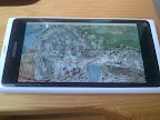
Saturday May 5, 2012 #
Note
 |
Need some polishing, but not bad and quite useable already.
Running 20:07 2.65 km (7:35 / km) +15m 7:22 / km
ahr:118 max:140
Running 19:34 2.67 km (7:19 / km) +24m 7:00 / km
ahr:120 max:144
Running 1 [0] 0.0 km
ahr:123 max:165
Friday May 4, 2012 #
Note
Working with QuickRoute style gps track overlay making app for my cell phone. If I can using the cell phone to download gps data from logger and take a photo of a map with the 9 mpix camera, and post images to DOMA, so why not making the gps track overlay with it too?
 |
Wednesday May 2, 2012 #
Trail running 1:22:45 [2] 11.09 km (7:28 / km)
