Training Log Archive: Mr WonderfulIn the 7 days ending Jun 8, 2013:
| |||||||||||||||||||||||||||||||||||||||||||||||||||||||||||||||||||||||||||||||||||||||||||||||||||||||||
| « | » |
| » now | ||||||||||
| Su | Mo | Tu | We | Th | Fr | Sa | |||||||
Saturday Jun 8, 2013 #
7 AM
Orienteering 1:06:01 4.72 mi (13:59 / mi) +101m 13:07 / mi
ahr:151 max:175 spiked:17/17c shoes: Roclite #2
Streamering for Igor's first visit to the Badlands.
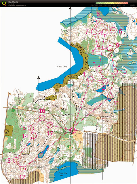
Parked off McCabe for efficiency, starting with #4.
En route to #4, I noticed some of those little "miss dig" type flags, the little 2x2 squares on a small wire as the post. And then I kept noticing them. Essentially my o course was a tour of the obstacle course race set up in the Badlands.
Good news: Permitting should be easy! "Hey, you let people drag tires all over the place, we just want to run around some of the sandy ridges."
I saw so many more places to put flags - the bowls just south of the line from 8-9. The nature of this terrain maybe would work for an o interval - do easy long distance navigating, then pound a bunch of rapid fire stuff up and over and around.
Probably should have done 9-11 to show that swampy area.
#14 was green, I should have noticed that.
#8 was overlooking some obstacle activity. And #16 was marked on some sort of tire hoist, kind of odd.
#17 shows that some options with all the little veg clumps here and there.
#18 was not easy to access from the road undershooting. Little greener than I hoped.
Looks like I placed #12 a little NE of circle, but I was swagging the circle off the satellite, so I forgive myself. Hopefully it wasn't too annoying.
Woot, #2 was about right! I love that little knoll. For a real meet I would put it on the backside, hidden from the trail.
Awesome to be out here with a map. For contour training, it's nice to be able to see the terrain unimpeded!
10 AM
Canoeing 2:57:42 10.52 mi (16:54 / mi) +3m 16:53 / mi
ahr:109 max:150 slept:5.0 shoes: Pirate Canoe
AR = Advanced Recon, since there are no terrain embargoes at the local level. Put in at the park in Holly and paddled over to Lake Pomenah. Was twisty but in good shape until Fenton, then we had a dozen log hops - quite a sense of deja vu!
One sort of tip. I ended up out of the boat anyway. A few really big wobbles!
Shane and Maria rocked it out. They work well.
One sort of tip. I ended up out of the boat anyway. A few really big wobbles!
Shane and Maria rocked it out. They work well.
2 PM
Biking 1:37:41 17.3 mi (10.6 mph) +129m
ahr:129 max:164 shoes: Jamis Dragon Sport 29er
Bike from take out to put in via Seven Lakes and some of their single track. That trail system is confusing - no signage on the park roads, and no idea which direction bikes are supposed to run. Also, it seems somewhat unused. First part we used looked not so good for O - very green, but towards the end it had some interesting looking bits, small ponds, reentrants with ponds up a the top. Interesting assortment of elevations for the water.
Then back to Holly on some busier roads - probably should have planned that a little better, but no one got run over.
Then back to Holly on some busier roads - probably should have planned that a little better, but no one got run over.
Wednesday Jun 5, 2013 #
7 PM
Walking 46:00 [0] 2.6 mi (17:42 / mi)
shoes: Barefoot
Barefoot to toughen feet. Many cringe moments on small rocks.
http://www.mapmyrun.com/view_workout?w=295981341
http://www.mapmyrun.com/view_workout?w=295981341
Tuesday Jun 4, 2013 #
Note
Jeff McW told me about an Adventure Day at Proud Lake on August 17th. Apparently 2000 people attended last year; might be a good audience for a SMOC booth. Maybe I will cross off any Wilderness Traverse activities to promote nav sports locally.
http://www.michigan.gov/som/0,4669,7-192-29907_299...
http://www.michigan.gov/som/0,4669,7-192-29907_299...
Sunday Jun 2, 2013 #
Note
Equipment needed before fall season:
Spikes
Gaiters
Spikes
Gaiters
8 AM
Orienteering 1:39:30 *** 5.82 mi (17:06 / mi) +268m 14:57 / mi
ahr:151 max:178 spiked:14/17c shoes: Inov8 Roclite 319
Bloody fantastic training course. Thanks Igor!
Pretty satisfied on the whole. Only really missed #9, just undershot it, but never left the circle.
Did bobble #5, thought it was at the distinct tree at first, ran past the streamer, had to look around a little.
Not sure if I touched correct streamer for #12, but I ran mostly through the circle center, so if that dirty orange one I touched wasn't it, I think I would've found the flag anyway.
Missed a little on #17, thought it looked slightly north side of hill, but I was oddly right on in the terrain, so when I tried the other hill past it, I said no way and went back to look around a bit more.
Some poor trail choices, but all were livable even if not optimal. Very encouraging run.
C • #12 1
4 PM
Walking 2:10:00 [1] 8.77 mi (14:49 / mi)
shoes: Brooks Ghost Blue
Kensington loop
Submitted canoe o permit for 8/24.
With wife and 10 lb pack.
http://www.mapmyrun.com/view_workout?w=293109715
Submitted canoe o permit for 8/24.
With wife and 10 lb pack.
http://www.mapmyrun.com/view_workout?w=293109715