Training Log Archive: BashIn the 7 days ending Aug 18, 2013:
| ||||||||||||||||||||||||||||||||||||||||
| « | » |
| » now | ||||||||||
| Mo | Tu | We | Th | Fr | Sa | Su | |||||||
Friday Aug 16, 2013 #
Note
I'm a bit of a princess about birthdays. I like to do something active in the outdoors, preferably at a special place like a mountain top or a rocky campsite on an Ontario lake. I set aside my "to do" list and indulge in guilty pleasures like quiet time with a good book, a wonderful dinner with 'Bent and extra dessert.
This year I was a little bummed to miss that fun since I'd need to work the first of three incredibly intense, sleepless days as volunteer Wilderness Traverse Race HQ manager. (Which is also fun - but not in the same way!) But all the Attackpointers (and others) who responded to my blatant request for birthday hugs - both online in your greetings on my AP log and in real life - increased the fun factor considerably. And I want to say a huge THANK YOU to Bob and Shannon for getting the biggest birthday cake of my life to share with 150 of my closest friends at the race briefing. Awesome. :)
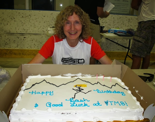
Btw I'm wondering if Picasa Web Albums has introduced some nifty new Google feature that "enhances" photos. The original is sharp and a little dark but I can't find a way to upload the photo without getting it brighter and blurry. I wonder if I'll be forced to change to Flickr. Anyone know what's up?
[EDIT: Ironically, thanks to Google, I found the answer. Google+ is rolling out a new "Auto Enhance" feature that is applied by default when a photo is unloaded. Presumably, Google+ users were informed but those of us who only use Picasa were not. I've created a Google+ profile so I can turn it off. Next step will be to see if I can disable Google+ afterward. I'd already done that in the past since Google+ makes Picasa hard to use. It may be Flickr time soon anyway. Here's what the photo looked like before Auto Enhance.]

To be fair to Google, if the photo had been taken after the race finished on Sunday following a night with no sleep, I actually *would* have looked - and sounded - that blurry.
This year I was a little bummed to miss that fun since I'd need to work the first of three incredibly intense, sleepless days as volunteer Wilderness Traverse Race HQ manager. (Which is also fun - but not in the same way!) But all the Attackpointers (and others) who responded to my blatant request for birthday hugs - both online in your greetings on my AP log and in real life - increased the fun factor considerably. And I want to say a huge THANK YOU to Bob and Shannon for getting the biggest birthday cake of my life to share with 150 of my closest friends at the race briefing. Awesome. :)
Btw I'm wondering if Picasa Web Albums has introduced some nifty new Google feature that "enhances" photos. The original is sharp and a little dark but I can't find a way to upload the photo without getting it brighter and blurry. I wonder if I'll be forced to change to Flickr. Anyone know what's up?
[EDIT: Ironically, thanks to Google, I found the answer. Google+ is rolling out a new "Auto Enhance" feature that is applied by default when a photo is unloaded. Presumably, Google+ users were informed but those of us who only use Picasa were not. I've created a Google+ profile so I can turn it off. Next step will be to see if I can disable Google+ afterward. I'd already done that in the past since Google+ makes Picasa hard to use. It may be Flickr time soon anyway. Here's what the photo looked like before Auto Enhance.]
To be fair to Google, if the photo had been taken after the race finished on Sunday following a night with no sleep, I actually *would* have looked - and sounded - that blurry.
Thursday Aug 15, 2013 #
Note
As much as I love Wilderness Traverse, the pre-race preparation has pre-empted my birthday for the past couple of years. Tomorrow will be more of the same - no celebration since I'll be kicking off 3 days of volunteering in a sleepless state. I've decided that in lieu of candles (which could be a fire hazard at my age anyway), I will require a mandatory hug from Attackpoint friends at registration. Please add this item to your list. :)
Tuesday Aug 13, 2013 #
Note
French Fail:
I wanted to say in an e-mail to a Québecois friend that I am excited to run in the Alps. I wasn't sure which word would be best for "excited" in this instance so I checked with Google Translate, which suggested both "ravie" and "excitée", the words I wanted to decide between. So I wrote my sentence in French to see if the English translations suggested a preference.
"Je suis ravie de courir dans les Alpes."
Which translated to: "I am delighted to run in the Alps."
Well, that sounded a little stuffy so I figured I should go with "excitée". But maybe I should just check it too.
"Je suis excitée de courir dans les Alpes."
Google Translation: "I am horny to run in the Alps."
So I guess I'm "delighted" about it then. Phew, that was close!
5 PM
Note
Here's a reprise of the most irresistible UTMB video I've seen. I sure hope the weather is good enough to see those beautiful mountains!
For the past 3 years, participants have been unable to get around Mont Blanc on the standard course so my fingers are tightly crossed, and I'm mentally prepared for a change in plans. Organizers have provided detailed information on alternate courses they will use if the weather is bad at the start or deteriorates during the event.
For the past 3 years, participants have been unable to get around Mont Blanc on the standard course so my fingers are tightly crossed, and I'm mentally prepared for a change in plans. Organizers have provided detailed information on alternate courses they will use if the weather is bad at the start or deteriorates during the event.
Monday Aug 12, 2013 #
Note
For those thinking of running UTMB, this split estimator will come in handy. (Thanks, LegendaryRandy!) There is probably another one for CCC but you can get an idea by looking at the splits from Courmayeur.
http://climbers.net/race/UltraTrail-du-MontBlanc-U...
Dee also shared her race plan with splits - although she ended up running faster.
I doubt this will be of interest to anyone who isn't going but just in case... You can sign up for text notifications from UTMB and CCC at this link. It's 5 Euros to register and 3 Euros per CCC runner and 5 Euros per UTMB runner. You can search for bib numbers by typing part of someone's name and hitting "Recherchez".
http://www.ultratrailmb.com/page/125/Suivi_par_SMS...
For UTMB, there should be about 20 updates along the course. I'm not sure if the website will have all the same info; I don't remember that many updates. I've signed up my Mom, and 'Bent and I will be monitoring each other since we race at different times. I'm also monitoring STORM since it will be nice to have a friend on the course "with" me, even though I'll never see him.
For those who *are* going, I hope you're watching the weather forecasts. The low in Chamonix (i.e. not up in the mountains where we will be) is forecast to hit -2C one night next week, although that is about 10 degrees lower than most nights. All the same, I am planning capris instead of shorts.
http://www.worldweatheronline.com/Chamonix-weather...
3 PM
Running (Trail) 3:02:57 [3] 22.5 km (8:08 / km) +801m 6:54 / km
shoes: Salomon Speedcross 3 Aqua
Last Hockley Loop before UTMB. I felt good running but I guess it was just the cooler weather because I didn't break any speed records. A few sections of the trail are quite overgrown with weeds up to my shoulders in the north east wetland.
Note to my future self: The Hockley Loop has changed between 3rd and 4th Line on the south side. I ran the old route today (now a side trail) because I was doing a test but in future, the loop will be a little longer.
At UTMB, I'll be wearing Speedcross that are nearly new. I've now run in them for a little over 60 km, which is enough. I could write a log entry just about the little things I've been testing recently, e.g. while we were in the Adirondacks, one of my two injuries was a cut on my upper arm from repeatedly rubbing against the pack pocket where I usually put my empty food wrappers. Who knew those things were so sharp? It works fine in shorter events but I've had to move my garbage for UTMB.
Btw my other injury in the ADKs was banging my knee hard into a big rock (OWWW!) and drawing a good splatter of blood but luckily not hurting the joint. Yup, I ran right into a rock in the middle of the trail. No, I cannot explain why.
If you get bored by GPS talk, it is time to stop reading this log entry. :)
Today's most important test was setting up an Ultrarunning mode in my Suunto Ambit with a 10-second recording interval and 60-second GPS fix and recording rate. It worked fine but it didn't take long to realize that "Pace" becomes meaningless and can be removed from the display. Currently, I'm planning to look at Elapsed Time, Distance, Altitude, Time of Day and Cumulative Ascent (just for kicks!) I can only see one number at a time without squinting - the big middle one - so I'm setting up modes I can cycle through to show Elapsed Time, Distance and Altitude as big numbers. If I want the other values, I'll just have to squint. :)
The first part of the test went really well. I charged my Ambit shortly before a 3-hour run and returned with 95% charge on the battery. So it's looking good for 44 hours of UTMB. It's rated at 50 hours, which is the main reason I switched to an Ambit.
Naturally, moving from 1-second GPS recording to 60-second GPS recording means a loss of accuracy but it wasn't terrible.
Typical Hockley Loop Measured Distances:
Garmin - 22.8 km
Ambit (1-second GPS recording) - 22.2 km
Ambit (60-second GPS recording) - 20.7 km
Typical Hockley Loop Elevation Gain:
Ambit (1-second GPS recording) - 820 m
Ambit (60-second GPS recording) - 801 m
(I ignore my Garmin since the Ambit is much more trustworthy with its barometric altimeter.)
The 60-second recording interval is going to be more accurate than I'd expected - especially since I'll be moving more slowly at UTMB (yes, the laws of physics permit that) and the trail likely won't have as many quick changes of direction as the Hockley Loop.
For folks who are really keen, the differences between the following tracks are quite visible.
Garmin Track of Hockley Loop
Ambit Track (1 sec)
Ambit Track (60 secs)