Training Log Archive: BashIn the 7 days ending Jul 14, 2013:
| |||||||||||||||||||||||||||||||||||||||||||||||||||||||||||||||||||||||||||||||
| « | » |
| » now | ||||||||||
| Mo | Tu | We | Th | Fr | Sa | Su | |||||||
Sunday Jul 14, 2013 #
12 AM
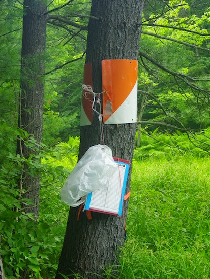
Orienteering race (Rogaine) 10:53:00 [3] 25.25 km (25:52 / km) +820m 22:15 / km
shoes: Salomon XA Pro - Navy 2nd pair
CNYO Rogaine
2013 U.S. Rogaining Championship
Connecticut Hill State Wildlife Area
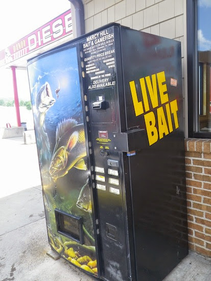
CNYO always puts on a great rogaine, and this year's race was also a qualifying event for the 2014 World Rogaining Champs in South Dakota. It was a tough decision to miss the Angry Seagull 24-hr adventure race in beautiful Temagami but with UTMB coming up, I opted for more time on my feet. The event was held in rural New York State. I was hoping for a Starbucks but this was all we found.
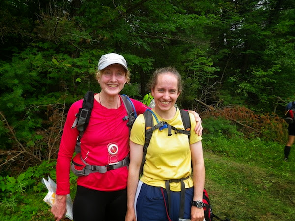
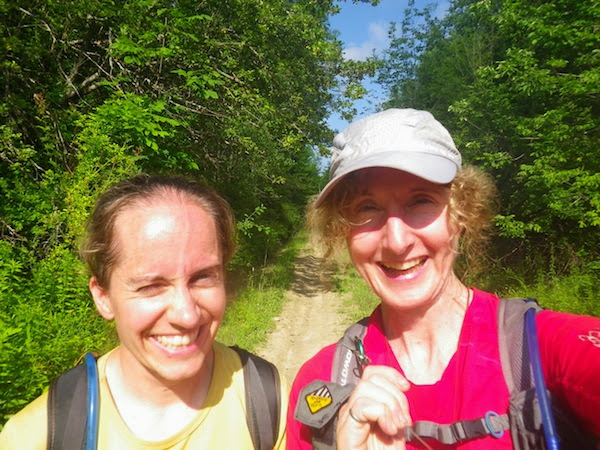
Arthurd (Stina Bridgeman) and I teamed up for the first time. She has stronger orienteering experience and I have more overnight racing experience. In a long event, we both focus on planning and navigating rather than running hard so we were a good combination! :)
Eric Smith had designed an interesting course with 60 controls spread over a large area. It looked like some teams would clear the course. Although the full distance was at the upper limit of what we might consider, we decided to plan our route with that possibility in mind, then we could make changes as necessary after we got a feel for the terrain. There were some big climbs and descents to slow us down but there were so many different ways to return to the finish line that we weren't taking any risks by starting out with a route plan that we knew was optimistic.
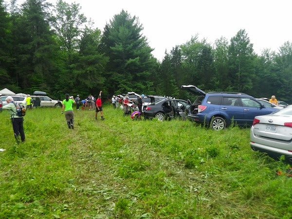
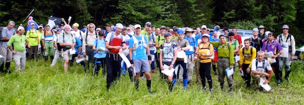
The turn-out for the event seemed pretty good. It was great to see so many friendly faces from the rogaining, orienteering and adventure racing communities.
We got off to a silly start by getting swept up in a crowd heading to the same first control (43) and not looking at our maps carefully. We arrived triumphantly at the wrong hilltop along with several other teams. After a mystified moment, we sheepishly made our way to the correct hilltop. Mr. and Mrs. GHOSLO punched the control just ahead of us and politely suppressed their giggles.

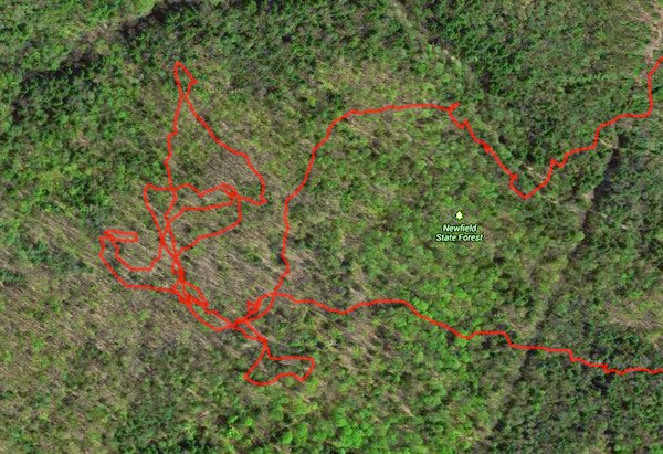
After that wake-up call, we both started paying attention to the map and (surprise!) things went much better. Arthurd has already posted a detailed report on our route and even a cool Quickroute map using her GPS data logger (no display) so I won't go into the same route detail here.
63-22
We got our first taste of the rocky, steep-sided creek valleys in this region - just a small one but it validated my decision to wear an ankle brace for the race. We were always sidehilling, climbing, descending or stepping on uneven ground so our feet got quite a workout. There were a lot of times when the slope was so steep that I was using trees to haul myself up - or to prevent myself from plummeting into rocky water far below. No way I could have trusted my bad ankle for 24 hours of that. I did at least half a dozen Superman dives during the event, sometimes from clumsiness and sometimes because of surprise holes or logs hidden by thick vegetation. I don't remember whether Arthurd fell even once. The terrain and forest sure were beautiful though!

From 22, we headed out to the road where - ACK! - there was an unavoidable patch of poison ivy running along the edge. I'd been hoping to steer clear of it because if it's not washed off within a couple of hours, you can't do much about it. Oh well.
20-75
Another steep climb then an entire *field* of poison ivy on our way to and from #75! I needed to tighten my shoelaces but didn't want to touch my gaiters or shoes anymore. I finally got the idea of holding big basswood leaves so I could adjust my shoes without touching them but it was awkward. I saw a few small patches during the rest of the race but this turned out to be our last major exposure. Arthurd isn't sensitive so I was the only one squealing and dancing around like an idiot!

57-66-77-33-62-35
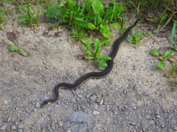
Now we were doing some seriously long, steep climbs. UTMB's trails cannot be harder than these scrambles! (Although the climbs will last a lot longer.) Somewhere in this section, we both yelled, "OUCH!" simultaneously. There was a sudden searing pain in my shin but neither of us had seen anything. Since Arthurd had suffered a similar fate at the exact same moment, we ruled out snakebites and invisible bear attacks.
It had to be some kind of rogaine-hating wasp or bee. We later learned that a lot of participants were stung on different sections of the course. My sting remained painful well into the evening, as if the stinger were still in there jostling around in spite of numerous attempts to get it out. Arthurd's pain faded more quickly, which was just as well since she got stung again later on. It wasn't all bad to have a big distraction like that since it made us unaware of any other pain or discomfort in our bodies.

61-48-71-60-50-58-36
After the water control at #35, we ran down the hill to the road and crossed over to the group of controls in the southeast corner of the map. With 20/20 hindsight, this is a section we could have omitted but we were still moving well and optimistic about getting as many controls as possible. When we got there and took a closer look at the private land boundaries complicating the big climb to #41, we made our first decision to drop a control. Then we gave our legs a great workout of climbing and descending as we picked up the rest of the controls.
Our one major bungle of the event was #58. Looking at Arthurd's track, it appears that we stayed on our bearing and arrived at the edge of the correct marsh within 5 m of the control. We can't imagine how we didn't see it but I *did* see some random flagging tape up the slope, so I dragged Arthurd up to the "control". We ended up investing 40 minutes and 2 km of walking in the area before we returned to that spot and found it. Several times we were ready to give up and move on like sensible people - but then we would see another clue and decide to give it just one more try. I think we're both equally stubborn! The silver lining is that we did find the control so our time up there wasn't completely wasted.


21-27-52
We ran down to the main road, then climbed an interminable hill on a road to get the next two controls.

After 52, we put on our headlamps.
54-55-39
With a good navigator as my teammate and a couple of strong headlamps, it wasn't much slower to move at night. Before long, we were at the next water stop.
78-44-64-38
Next we did a few long, hilly bushwhacks using direct bearings. With two of us looking at the map, things worked out pretty well, even in the dark. It also didn't hurt that our headlamps found the reflectors on the controls earlier at night than we could see them in the daytime. We were now quite certain that we were going to need to drop some controls from our route so we dropped 47 and 24 without the slightest bit of guilt.
It was about 11:40 p.m. when we got to the water stop at 38. Our damp feet were getting sore, and another team was there resting with their shoes off. This seemed like a good time to change into my spare socks, however, with everything below my mid-calf potentially contaminated with poison ivy, I wasn't sure if I could do it. Then I remembered the pair of surgical gloves that I carry in case of emergency so I sacrificed them.
25-72
Next was a rolling area with ski trails that were not always easy to see in the terrain but were nicely marked with little reflectors. I would like to ski here! Francis Falardeau's team was coming toward us as we headed to 72. Unfortunately, we came across this bench before we needed it. Later, it would have been *really* handy!

31
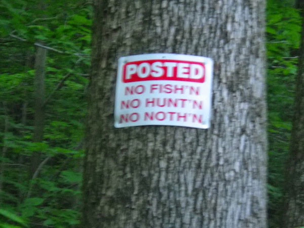
This was our other big screw-up. Organizers had asked racers to be especially careful to stay off private land since we were being permitted to race in a State Wildlife Management area for the first time in awhile. Often in New York state, the property boundaries are visible in the terrain marked with signs, paint on trees, etc. It's a strange concept for Ontarians but you can use property boundaries to navigate in New York - except not on this part of the map, it turns out. We needed to thread the needle between two pieces of private land and were counting on seeing some markers. We were also watching for a steep downhill but we were off bearing a little so it didn't happen as soon as expected. We knew we had gone too far but then we saw a very clear State Land corner marker. We cheerfully headed north - right through the private land, as it turned out. When we hit a big field, we finally wrapped our minds around our mistake. Adding insult to injury, this crazy detour took quite a bit more time. Oops.
56-51
Joe and Dave's winning Coed team was coming toward us on the way to #51. They said they hadn't seen another team in 7.5 hours. Our plan had been to head further north after this but Arthurd's feet were screaming now (about 3:45 a.m.) We started in that direction and took a break at the trail junction. Seeing how much pain she was in, I suggested that we turn around and head toward the finish, picking up a few controls along the way. Unfortunately, this meant descending the rocky trail that we'd just climbed up - the worst thing for shredded feet.
45-67-73-37
First light appeared shortly before 73, as did the tireless Eric Smith, who drove past us on the road to check the water jugs at #37. We took occasional breaks to get Arthurd off her raw, blistered feet. While resting at #37, I mentioned that we only needed 290 more points to hit 2000, which seemed like a nice round number. (The full course was 2700 points.) We both liked having a concrete goal, and from that point on, we constantly checked the map, looking for easier ways to get exactly 2000 points. We both had to do a recount of the points we'd earned so far. It would not do if we made an arithmetic error and accidentally finished with 1990 points!
79-59-42-69-23-53-Finish
Arthurd sailed up the hill to 79, as she had been doing the entire race; it was only the downhills that really hurt. Unfortunately, we had a lot of downhills after that so we took regular rest breaks in the sunshine. She was super tough to keep going; it would have been tempting to bail on the race. UntamedAdventure and his team stopped to chat briefly during one of our breaks; their feet were sore too.

The section of the Finger Lakes Trail that we followed after #53 on our way to the finish was spectacular - even with sore feet. It followed a beautiful creek with little rock shelves and waterfalls.


We finished at 10:53 a.m., by which time the weather was hot and humid, and we enjoyed excellent company along with CNYO's usual hospitality and good food. Most of the people we talked to had foot problems, and a lot were stung by bees or wasps. Sadly, this left us with nothing unique to complain about. :)
We were the first Women's Open team (of only two) so we pre-qualified for the 2014 World Rogaining Championship. The 2nd and 3rd place Coed teams - all of them very talented racers - had earned [EDITED] 2100 and 1920 points respectively so even though we limped to the finish, our score was respectable. (Merci for the pic, Francis!)
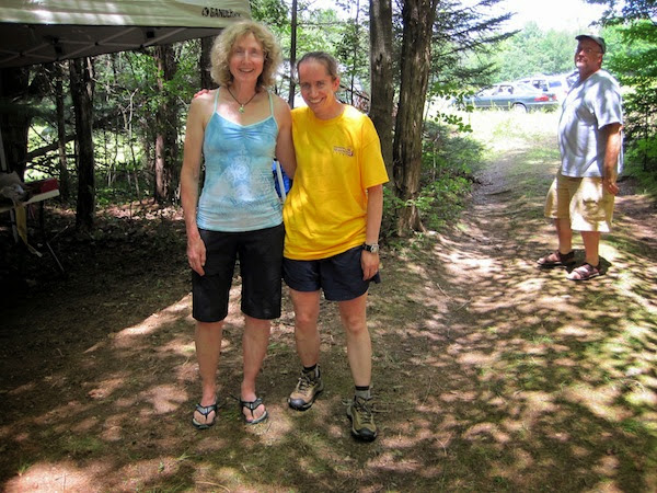
Big thanks to Arthurd for sharing her awesome navigation skills and for hanging in there on a tough day. And an *extra* special thanks to Abizeleth, who had heard about my Dairy Queen tradition and served up Ben & Jerry's ice cream with hot chocolate sauce right after my post-race shower. Yum, perfect. :) And of course, thanks to CNYO for once again working so hard to put on a terrific event!
2013 U.S. Rogaining Championship
Connecticut Hill State Wildlife Area
CNYO always puts on a great rogaine, and this year's race was also a qualifying event for the 2014 World Rogaining Champs in South Dakota. It was a tough decision to miss the Angry Seagull 24-hr adventure race in beautiful Temagami but with UTMB coming up, I opted for more time on my feet. The event was held in rural New York State. I was hoping for a Starbucks but this was all we found.
Arthurd (Stina Bridgeman) and I teamed up for the first time. She has stronger orienteering experience and I have more overnight racing experience. In a long event, we both focus on planning and navigating rather than running hard so we were a good combination! :)
Eric Smith had designed an interesting course with 60 controls spread over a large area. It looked like some teams would clear the course. Although the full distance was at the upper limit of what we might consider, we decided to plan our route with that possibility in mind, then we could make changes as necessary after we got a feel for the terrain. There were some big climbs and descents to slow us down but there were so many different ways to return to the finish line that we weren't taking any risks by starting out with a route plan that we knew was optimistic.
The turn-out for the event seemed pretty good. It was great to see so many friendly faces from the rogaining, orienteering and adventure racing communities.
We got off to a silly start by getting swept up in a crowd heading to the same first control (43) and not looking at our maps carefully. We arrived triumphantly at the wrong hilltop along with several other teams. After a mystified moment, we sheepishly made our way to the correct hilltop. Mr. and Mrs. GHOSLO punched the control just ahead of us and politely suppressed their giggles.
After that wake-up call, we both started paying attention to the map and (surprise!) things went much better. Arthurd has already posted a detailed report on our route and even a cool Quickroute map using her GPS data logger (no display) so I won't go into the same route detail here.
63-22
We got our first taste of the rocky, steep-sided creek valleys in this region - just a small one but it validated my decision to wear an ankle brace for the race. We were always sidehilling, climbing, descending or stepping on uneven ground so our feet got quite a workout. There were a lot of times when the slope was so steep that I was using trees to haul myself up - or to prevent myself from plummeting into rocky water far below. No way I could have trusted my bad ankle for 24 hours of that. I did at least half a dozen Superman dives during the event, sometimes from clumsiness and sometimes because of surprise holes or logs hidden by thick vegetation. I don't remember whether Arthurd fell even once. The terrain and forest sure were beautiful though!
From 22, we headed out to the road where - ACK! - there was an unavoidable patch of poison ivy running along the edge. I'd been hoping to steer clear of it because if it's not washed off within a couple of hours, you can't do much about it. Oh well.
20-75
Another steep climb then an entire *field* of poison ivy on our way to and from #75! I needed to tighten my shoelaces but didn't want to touch my gaiters or shoes anymore. I finally got the idea of holding big basswood leaves so I could adjust my shoes without touching them but it was awkward. I saw a few small patches during the rest of the race but this turned out to be our last major exposure. Arthurd isn't sensitive so I was the only one squealing and dancing around like an idiot!
57-66-77-33-62-35
Now we were doing some seriously long, steep climbs. UTMB's trails cannot be harder than these scrambles! (Although the climbs will last a lot longer.) Somewhere in this section, we both yelled, "OUCH!" simultaneously. There was a sudden searing pain in my shin but neither of us had seen anything. Since Arthurd had suffered a similar fate at the exact same moment, we ruled out snakebites and invisible bear attacks.
It had to be some kind of rogaine-hating wasp or bee. We later learned that a lot of participants were stung on different sections of the course. My sting remained painful well into the evening, as if the stinger were still in there jostling around in spite of numerous attempts to get it out. Arthurd's pain faded more quickly, which was just as well since she got stung again later on. It wasn't all bad to have a big distraction like that since it made us unaware of any other pain or discomfort in our bodies.
61-48-71-60-50-58-36
After the water control at #35, we ran down the hill to the road and crossed over to the group of controls in the southeast corner of the map. With 20/20 hindsight, this is a section we could have omitted but we were still moving well and optimistic about getting as many controls as possible. When we got there and took a closer look at the private land boundaries complicating the big climb to #41, we made our first decision to drop a control. Then we gave our legs a great workout of climbing and descending as we picked up the rest of the controls.
Our one major bungle of the event was #58. Looking at Arthurd's track, it appears that we stayed on our bearing and arrived at the edge of the correct marsh within 5 m of the control. We can't imagine how we didn't see it but I *did* see some random flagging tape up the slope, so I dragged Arthurd up to the "control". We ended up investing 40 minutes and 2 km of walking in the area before we returned to that spot and found it. Several times we were ready to give up and move on like sensible people - but then we would see another clue and decide to give it just one more try. I think we're both equally stubborn! The silver lining is that we did find the control so our time up there wasn't completely wasted.
21-27-52
We ran down to the main road, then climbed an interminable hill on a road to get the next two controls.
After 52, we put on our headlamps.
54-55-39
With a good navigator as my teammate and a couple of strong headlamps, it wasn't much slower to move at night. Before long, we were at the next water stop.
78-44-64-38
Next we did a few long, hilly bushwhacks using direct bearings. With two of us looking at the map, things worked out pretty well, even in the dark. It also didn't hurt that our headlamps found the reflectors on the controls earlier at night than we could see them in the daytime. We were now quite certain that we were going to need to drop some controls from our route so we dropped 47 and 24 without the slightest bit of guilt.
It was about 11:40 p.m. when we got to the water stop at 38. Our damp feet were getting sore, and another team was there resting with their shoes off. This seemed like a good time to change into my spare socks, however, with everything below my mid-calf potentially contaminated with poison ivy, I wasn't sure if I could do it. Then I remembered the pair of surgical gloves that I carry in case of emergency so I sacrificed them.
25-72
Next was a rolling area with ski trails that were not always easy to see in the terrain but were nicely marked with little reflectors. I would like to ski here! Francis Falardeau's team was coming toward us as we headed to 72. Unfortunately, we came across this bench before we needed it. Later, it would have been *really* handy!
31
This was our other big screw-up. Organizers had asked racers to be especially careful to stay off private land since we were being permitted to race in a State Wildlife Management area for the first time in awhile. Often in New York state, the property boundaries are visible in the terrain marked with signs, paint on trees, etc. It's a strange concept for Ontarians but you can use property boundaries to navigate in New York - except not on this part of the map, it turns out. We needed to thread the needle between two pieces of private land and were counting on seeing some markers. We were also watching for a steep downhill but we were off bearing a little so it didn't happen as soon as expected. We knew we had gone too far but then we saw a very clear State Land corner marker. We cheerfully headed north - right through the private land, as it turned out. When we hit a big field, we finally wrapped our minds around our mistake. Adding insult to injury, this crazy detour took quite a bit more time. Oops.
56-51
Joe and Dave's winning Coed team was coming toward us on the way to #51. They said they hadn't seen another team in 7.5 hours. Our plan had been to head further north after this but Arthurd's feet were screaming now (about 3:45 a.m.) We started in that direction and took a break at the trail junction. Seeing how much pain she was in, I suggested that we turn around and head toward the finish, picking up a few controls along the way. Unfortunately, this meant descending the rocky trail that we'd just climbed up - the worst thing for shredded feet.
45-67-73-37
First light appeared shortly before 73, as did the tireless Eric Smith, who drove past us on the road to check the water jugs at #37. We took occasional breaks to get Arthurd off her raw, blistered feet. While resting at #37, I mentioned that we only needed 290 more points to hit 2000, which seemed like a nice round number. (The full course was 2700 points.) We both liked having a concrete goal, and from that point on, we constantly checked the map, looking for easier ways to get exactly 2000 points. We both had to do a recount of the points we'd earned so far. It would not do if we made an arithmetic error and accidentally finished with 1990 points!
79-59-42-69-23-53-Finish
Arthurd sailed up the hill to 79, as she had been doing the entire race; it was only the downhills that really hurt. Unfortunately, we had a lot of downhills after that so we took regular rest breaks in the sunshine. She was super tough to keep going; it would have been tempting to bail on the race. UntamedAdventure and his team stopped to chat briefly during one of our breaks; their feet were sore too.
The section of the Finger Lakes Trail that we followed after #53 on our way to the finish was spectacular - even with sore feet. It followed a beautiful creek with little rock shelves and waterfalls.
We finished at 10:53 a.m., by which time the weather was hot and humid, and we enjoyed excellent company along with CNYO's usual hospitality and good food. Most of the people we talked to had foot problems, and a lot were stung by bees or wasps. Sadly, this left us with nothing unique to complain about. :)
We were the first Women's Open team (of only two) so we pre-qualified for the 2014 World Rogaining Championship. The 2nd and 3rd place Coed teams - all of them very talented racers - had earned [EDITED] 2100 and 1920 points respectively so even though we limped to the finish, our score was respectable. (Merci for the pic, Francis!)
Big thanks to Arthurd for sharing her awesome navigation skills and for hanging in there on a tough day. And an *extra* special thanks to Abizeleth, who had heard about my Dairy Queen tradition and served up Ben & Jerry's ice cream with hot chocolate sauce right after my post-race shower. Yum, perfect. :) And of course, thanks to CNYO for once again working so hard to put on a terrific event!
Saturday Jul 13, 2013 #
Event: CNYO Rogaine XXIII
12 PM
Orienteering race (Rogaine) 12:00:00 [3] 43.19 km (16:40 / km) +1679m 13:57 / km
shoes: Salomon XA Pro - Navy 2nd pair
Day 1, noon till midnight. (See Sunday's log for race report.)
Friday Jul 12, 2013 #
Note
Salomon Niagara Outlet Tent Sale - XA20 packs were $39.95. Of course I had to get one.
6 PM
Paddling (Kayak) 30:00 [2]
After the long drive to NY, it was nice to unwind with a pre-dinner paddle on Canandaigua Lake with Arthurd. We chatted with Ang, who was swimming. Afterward, a bunch of us went to dinner including APers JayXC, Abizaleth, Ang, Arthurd and Share.
Thursday Jul 11, 2013 #
Note
All the best to everyone doing Angry Seagull this weekend. Temagami is a beautiful area, and I envy your chance to paddle up there. Be safe, race smart and have loads of fun!
It was a tough call but Arthurd and I are going to try to qualify for the 2014 World Rogaining Championship by racing in New York this weekend at the U.S. Rogaining Champs. I guess we're lucky to have too many good choices on these summer weekends!
It was a tough call but Arthurd and I are going to try to qualify for the 2014 World Rogaining Championship by racing in New York this weekend at the U.S. Rogaining Champs. I guess we're lucky to have too many good choices on these summer weekends!
Wednesday Jul 10, 2013 #
Note
The instructions specify that I'll need the following:
- Large bag of white plastic party knives
- Up to four or more gallons of ammonia (regular or lemon)
- Courage
What am I planning to do? (If I can find the courage.) No googling allowed and 'Bent isn't allowed to guess.
- Large bag of white plastic party knives
- Up to four or more gallons of ammonia (regular or lemon)
- Courage
What am I planning to do? (If I can find the courage.) No googling allowed and 'Bent isn't allowed to guess.
10 AM
Running (Country Road) 57:22 9.29 km (6:10 / km) +156m 5:42 / km
shoes: Salomon XR Crossmax - Blue 2nd
After not wearing socks for the past few days to help my blisters heal, I put on shoes briefly to go around our block. It's a hilly country route with loose gravel but the odds of turning my ankle are low so it was a good choice for today. I really wouldn't want to hurt myself so close to the CNYO Rogaine! The ankle isn't feeling unstable but it will be a couple of months before I have good confidence in it again.
Hot, hot, HOT and oppressively humid. It was sunny but the weather felt ominous. There were strangely shaped clouds and sudden gusts of wind in between periods where I felt like I was running in a jungle. I tried a Columbia Omnifreeze shirt and didn't feel any cooler while running than I do in a Salomon trail shirt where the fabric is lighter and provides evaporative cooling. When I stopped afterward to do some stretching outside in the shade, I think I felt the cooling effect. Maybe if I got the shirt wet in a river instead of just sweating in it?
Hot, hot, HOT and oppressively humid. It was sunny but the weather felt ominous. There were strangely shaped clouds and sudden gusts of wind in between periods where I felt like I was running in a jungle. I tried a Columbia Omnifreeze shirt and didn't feel any cooler while running than I do in a Salomon trail shirt where the fabric is lighter and provides evaporative cooling. When I stopped afterward to do some stretching outside in the shade, I think I felt the cooling effect. Maybe if I got the shirt wet in a river instead of just sweating in it?
1 PM
Strength & Mobility (Legs) 22:00 [1]
Mostly balance and mobility today with minimal strength since there's no point overstressing anything right before a 24-hr race. Coach LD will be pleased to hear that I did 20 teapots on each side without putting my foot down. My balance is annoyingly better on the injured side.
I invented a fun new balance exercise today! Stand on one foot on a Bosu ball while dancing as energetically as you dare with Riverdance arms (harder to balance) to the full length of "Mari Mac" by Great Big Sea. Try it. You will laugh.
I invented a fun new balance exercise today! Stand on one foot on a Bosu ball while dancing as energetically as you dare with Riverdance arms (harder to balance) to the full length of "Mari Mac" by Great Big Sea. Try it. You will laugh.
Tuesday Jul 9, 2013 #
Note
Busy day! Great to have lunch with adventure racer Pat Chan, visiting from Edmonton for a conference.
The airport got 126 mm of rain yesterday - considerably more than Toronto and even more than what it got during Hurricane Hazel more than 50 years ago. That's the storm that most people talk about when they're designing infrastructure around here. Today there was little evidence of last night's record deluge, although one exit off Hwy 427 was closed so that a crew could pump water off the ramp.
The airport got 126 mm of rain yesterday - considerably more than Toronto and even more than what it got during Hurricane Hazel more than 50 years ago. That's the storm that most people talk about when they're designing infrastructure around here. Today there was little evidence of last night's record deluge, although one exit off Hwy 427 was closed so that a crew could pump water off the ramp.
Monday Jul 8, 2013 #
Note
Why is Toronto trying to copy Calgary?!?! Rain, rain, go away.

11 AM
Note
Sending lots of love Carbon's way on the eve of her most important summer event - surgery. Your Attackpoint family will be here for you as soon as you turn your phone on afterward! :)
12 PM
Note
Ladies, does this hot weather have you looking for an additional hydration system for your long runs or bike rides? Good news - your search is over, and the shipping is free. It's called the The WineRack. I know what you're thinking, and don't you worry: "With a simple blow into the tube it's easy to keep that full look even as you drink from your secret stash."

No need to feel left out, gentlemen! They also make the The Beerbelly Deluxe with Pleasure Extender. (That's a cold pack, btw.) I couldn't make this stuff up.
No need to feel left out, gentlemen! They also make the The Beerbelly Deluxe with Pleasure Extender. (That's a cold pack, btw.) I couldn't make this stuff up.