Training Log Archive: BashIn the 7 days ending Oct 31, 2010:
| |||||||||||||||||||||||||||||||||||||||||||||||||||||||||||||||||||||||||||||||||||||||||||||||||||||||||
| « | » |
| » now | ||||||||||
| Mo | Tu | We | Th | Fr | Sa | Su | |||||||
Sunday Oct 31, 2010 #
Orienteering 2:09:00 [2] 14.0 km (9:13 / km)
shoes: Poison Ice Bugs
Peak-2-Peak training session at Mount Nemo. I took the "training" vs. "competition" aspect of the event to heart more than I should have! I re-ran a section of trail to pose for a photo, said hello to a bunch of friends on the course, and stopped several times to perform acts of O-vangelism, i.e. explaining to other park users what the crazy map runners were doing - and petting their dogs too. In one section where I was running well for a change, I got a thorn in my toe through the sole of a double-tied shoe - sigh, another long stop. Bottom line... I had a great time running around in the woods and I found all the controls - but I was seriously unfocused. On the bright side, I got to do a 14 km run on a 10 km orienteering course for just $15! :-)
Running warm up/down 5:00 [1]
Note
A friend got tickets from Russ Courtnall for Battle of the Blades tonight. Always fun to be in the audience of a TV production! Dr. Wells treats the athletes and was kind enough to take me on a backstage tour where I saw all the performers. Cool!
Saturday Oct 30, 2010 #
Paddling (Kayak Erg) 1:00:00 [2]
Paddling in the basement. Not as boring as I thought it would be which is good because I'll probably be doing a lot of it before Coast to Coast in February.
Note
'Bent and I and others spent a couple of hours carrying boxes and furniture to help a friend move out of a legally awkward domestic situation. Boys and girls, choose your partners carefully and be *especially* cautious about the decision to move in together. 'Nuff said.
Friday Oct 29, 2010 #
12 PM
Note
The following event announcements were made on Facebook yesterday:
"Mark your calendars and get ready to explore the Canadian Shield! On Sat. Sept. 10, 2011, Logs Rocks & Steel will move to an exciting new host venue in Muskoka - YMCA Camp Pinecrest in Torrance."
"Mark your calendars... Wilderness Traverse 2011 is happening on Aug. 19-21 - great summer weather and no bugs!"
If you're on Facebook and want to "like" either event (which sends occasional updates and photos to your news feed), these are the links:
Logs Rocks and Steel
Wilderness Traverse
While you're at it, why not "like" Salomon Dontgetlost.ca Adventure Running too? :-)
Thursday Oct 28, 2010 #
Note
Our nordic skier friend VO2Max texted to say that the AP nickname I've assigned him is apparently a reasonable choice. In this week's testing, he had the highest VO2Max at the Alberta World Cup Academy! (73.5)
Strength & Mobility (Core) 22:00 [2]
Hard Core Live with Caron.
Power Yoga 51:00 [1]
A "Hard, Harder, Hardest" class where we moved through progressions of poses. Caron's husband Barrie Shepley asked whether she might do an "Easy, Easier, Ridiculously Simple" class some time. Nice to have 'Bent at Core/Yoga tonight. He's still rehabbing but he's on his way back!
11 AM
Running intervals (Trail) 1:15:00 11.5 km (6:31 / km)
shoes: Salomon XT Wings - Tomato
(Actual time on trails 1:50.) Volunteered at the Caledon elementary school cross-country running meet at Albion Hills. I thought I'd be working the finish line but signals got crossed and they were counting on me to ride my bike as the "rabbit" in front of the runners. I didn't have my bike so I offered to change places with the "turtle" who rode at the back and said I could be the turtle on foot. So I ran at the back as sweep in five different hilly trail races. I wasn't dressed for running at all except for my XT Wings!
I've learned that up to Grade 5, kids only have two speeds - walking and 20 kph. In Grade 6, they can run 2.8 km without stopping. Even the slowest boys on the Grade 6 cross-country teams were darned good runners so I got a decent workout. It was fun encouraging the younger kids, "Come on - let's run this downhill section." One little 8-year-old boy kept asking, "Is this downhill?". He honestly couldn't seem to tell. He then explained (from the back of the pack), "I'm a very good runner but my best sport is sky diving." "Oh... really?" "Yes, I take my parachute and jump off the second storey of our barn." Hmm...
Considering that I'd planned to rest my legs after yesterday's big course test, I've earned some serious chocolate today!
Wednesday Oct 27, 2010 #
Note
It's getting late in the season and Bob M. and I needed to get out one more time to test an epic trek we're planning for Wilderness Traverse 2011. (I'm assistant race director for next year.) There's a distinction between course scouting, which we did last weekend, and a course test. Scouting is exploration - maybe looking for a portage between two lakes or checking a trail to see if it would be good for biking. In a test, we start at a CP and go to one or more CPs in sequence using the same mode of travel that the competitors will use.
Unlike scouting expeditions, where my Garmin Forerunner and - surprisingly - my iPhone can provide helpful info, we only allow ourselves to use map and compass to navigate - the same tools the competitors will have. We test in daylight because of the things we're looking for but we have to consider any implications related to the time of day when different types of competitors will do the section.
This year I've been learning about the incredible number of variables involved in planning a long adventure race course - safety considerations (e.g. navigation catch features, rescue routes for first aid crews), landowner permissions, establishing CP locations that will be accessible by volunteers, squinting at satellite maps, learning about trail networks and designing the course with their existence in mind, setting up interesting route choices, selecting terrain for each discipline that is challenging but not too unpleasant, planning short course options that are fun and worth doing, finding TA locations that are big enough and thinking about gear transportation between them, solving the tricky puzzle of linking all the different sections together, and finding/booking a host venue of the right size that happens to be appropriately located for the finish of a wilderness race.
Respect to all the race directors out there who do this work so we can indulge our adventure racing habit. This stuff may look simple when we arrive at the race venue and get our maps and instructions but there's a huge amount of time that goes into it and nobody is getting rich from AR.
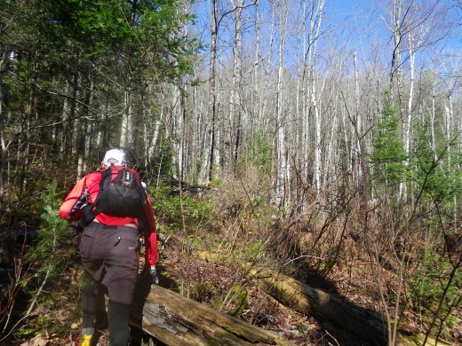
Today's trek was longer than either of last year's WT trekking sections. We explored a few trails out of curiosity, which increased our distance, but it would still be a 30+ km trek if we had just travelled directly between CPs. I felt that the navigation was more intricate than last year's long trek. Most bodies of water were smaller so they didn't provide the same huge targets and handrails that we had in 2010. It's not the kind of course where the best navigators will just set a compass bearing and bash through the woods for 5 km but there are handrails and landmarks that will allow midpack teams to navigate safely with a little less precision.

Bob and I are accustomed to being the primary navigators on our respective teams so it won't surprise anyone that we often debate who is going to navigate. What *might* surprise people is that the discussions go like this: "No, YOU navigate this section. I navigated the last one!" Outside of a race context and accompanied by another navigator, I'm afraid we get lazy! However, after the initial agreement about who's going to be in charge, we both follow the map with an eagle eye, talk about features we're seeing and offer "helpful" commentary to the current lead navigator. For the most part, we like the same types of route choices although Bob will follow a trail longer than I will. That's probably because he makes me run the trails so I'm always keen to bushwhack since it lets me catch my breath!

We hit the nav well today - a nice improvement compared to our WT2010 tests when there were a couple of legs with too much AR chat and not enough compass.
There were some beautiful open areas where we could make good time.

There were also some alder-filled wetlands - but fortunately nothing as bad as that heinous bikewhack during the first night of Untamed New England. That's the standard against which I now evaluate every wetland bushwhack.


We missed having Hammer there to tell us whether we were splashing through a fen, swamp, marsh or whatever.
There was one large area where it looked like a microburst had caused significant blowdown of huge trees. This was a little disconcerting given that we had inadvertently gone into the woods on a day with 70 kph wind gusts. That, along with the limited hours of daylight, kept our pace up.

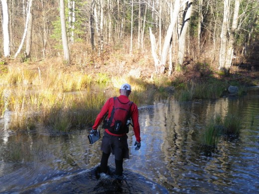
The water was cold but - unlike last year's WT course - it was rarely more than knee deep and there were no tempting route choices that involved swimming. I went up to my waist once because I couldn't jump across a creek after Bob succeeded but that's as wet as it got. Since next year's race is in August, conditions probably won't be much wetter and the water will be warm.

Bob has a roaring metabolism and never brings enough food. Good thing we found this moose.

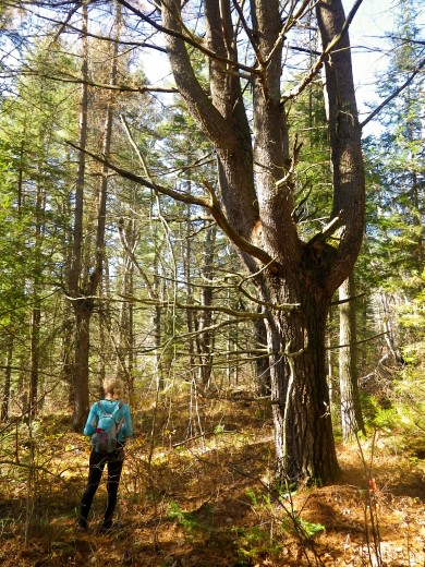
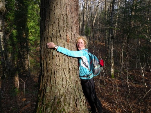
Once a Tree Hugger, always a Tree Hugger...
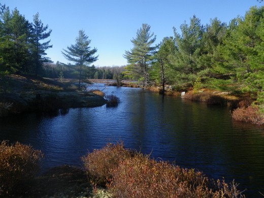
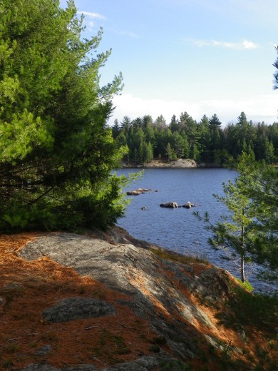
Great terrain!


And that's the end of course testing until next spring but the most important scouting/testing is done and the host venue should be announced shortly.

Unlike scouting expeditions, where my Garmin Forerunner and - surprisingly - my iPhone can provide helpful info, we only allow ourselves to use map and compass to navigate - the same tools the competitors will have. We test in daylight because of the things we're looking for but we have to consider any implications related to the time of day when different types of competitors will do the section.
This year I've been learning about the incredible number of variables involved in planning a long adventure race course - safety considerations (e.g. navigation catch features, rescue routes for first aid crews), landowner permissions, establishing CP locations that will be accessible by volunteers, squinting at satellite maps, learning about trail networks and designing the course with their existence in mind, setting up interesting route choices, selecting terrain for each discipline that is challenging but not too unpleasant, planning short course options that are fun and worth doing, finding TA locations that are big enough and thinking about gear transportation between them, solving the tricky puzzle of linking all the different sections together, and finding/booking a host venue of the right size that happens to be appropriately located for the finish of a wilderness race.
Respect to all the race directors out there who do this work so we can indulge our adventure racing habit. This stuff may look simple when we arrive at the race venue and get our maps and instructions but there's a huge amount of time that goes into it and nobody is getting rich from AR.
Today's trek was longer than either of last year's WT trekking sections. We explored a few trails out of curiosity, which increased our distance, but it would still be a 30+ km trek if we had just travelled directly between CPs. I felt that the navigation was more intricate than last year's long trek. Most bodies of water were smaller so they didn't provide the same huge targets and handrails that we had in 2010. It's not the kind of course where the best navigators will just set a compass bearing and bash through the woods for 5 km but there are handrails and landmarks that will allow midpack teams to navigate safely with a little less precision.
Bob and I are accustomed to being the primary navigators on our respective teams so it won't surprise anyone that we often debate who is going to navigate. What *might* surprise people is that the discussions go like this: "No, YOU navigate this section. I navigated the last one!" Outside of a race context and accompanied by another navigator, I'm afraid we get lazy! However, after the initial agreement about who's going to be in charge, we both follow the map with an eagle eye, talk about features we're seeing and offer "helpful" commentary to the current lead navigator. For the most part, we like the same types of route choices although Bob will follow a trail longer than I will. That's probably because he makes me run the trails so I'm always keen to bushwhack since it lets me catch my breath!
We hit the nav well today - a nice improvement compared to our WT2010 tests when there were a couple of legs with too much AR chat and not enough compass.
There were some beautiful open areas where we could make good time.
There were also some alder-filled wetlands - but fortunately nothing as bad as that heinous bikewhack during the first night of Untamed New England. That's the standard against which I now evaluate every wetland bushwhack.
We missed having Hammer there to tell us whether we were splashing through a fen, swamp, marsh or whatever.
There was one large area where it looked like a microburst had caused significant blowdown of huge trees. This was a little disconcerting given that we had inadvertently gone into the woods on a day with 70 kph wind gusts. That, along with the limited hours of daylight, kept our pace up.
The water was cold but - unlike last year's WT course - it was rarely more than knee deep and there were no tempting route choices that involved swimming. I went up to my waist once because I couldn't jump across a creek after Bob succeeded but that's as wet as it got. Since next year's race is in August, conditions probably won't be much wetter and the water will be warm.
Bob has a roaring metabolism and never brings enough food. Good thing we found this moose.
Once a Tree Hugger, always a Tree Hugger...
Great terrain!
And that's the end of course testing until next spring but the most important scouting/testing is done and the host venue should be announced shortly.
9 AM
Trekking 8:04:26 35.0 km (13:50 / km)
shoes: Salomon XA Pro Ult - 2 Tomato
Getawaystix and I tested an epic trekking section from Wilderness Traverse 2011. Great day and now I can eat all the chocolate I want for the rest of the week.
Tuesday Oct 26, 2010 #
Note
Photos and report are now posted for Saturday's Wilderness Traverse course scouting trip.
http://www.attackpoint.org/viewlog.jsp/user_920/pe...
http://www.attackpoint.org/viewlog.jsp/user_920/pe...
Monday Oct 25, 2010 #
Note
For the first time ever, 'Bent and I went to a candidate's party and held our breath as we watched municipal election returns trickle in over 2 hours. The cheering and excitement was greater than any sports event because the results actually affect us in our small town.
For those of you in Toronto... you have my sympathy. Here in Caledon, we've had an incredibly rough few years. At the mild end of the scale, developer-supported lobby groups have spread misinformation - even setting up their own propaganda-filled newspaper - and have done their best to prevent our local government from moving forward on important issues.
Things got much nastier - threats, multi-million dollar lawsuits, a complaint leading to a police investigation into the Mayor's records that showed no evidence of wrongdoing, and even a violent physical assault on her cancer-stricken husband after she refused to vote as they wished.
I'm one of many people who couldn't just watch this happen, so I got involved back in 2008. Since then, I've attended dozens of meetings, read hundreds of pages, written letters and press releases, circulated a petition and exchanged countless e-mails. And last night, passing over a slate of developer-supported candidates with glossy campaign literature, the citizens of Caledon came through, voting in an honest, hard-working Mayor and Council who will work well together and who share a progressive vision for our town. I wouldn't have believed it possible to come home after a local election with a sore throat from cheering and tears in my eyes but I was far from the only one. The next four years won't be easy but tonight was a terrific start.
10 AM
Note
Photos and report are posted below from Friday's course scouting for Logs Rocks and Steel.