Training Log Archive: BashIn the 7 days ending May 17, 2009:
| ||||||||||||||||||||||||||||||||||||||||||||||||||||||||||||||||||
| « | » |
| » now | ||||||||||
| Mo | Tu | We | Th | Fr | Sa | Su | |||||||
Sunday May 17, 2009 #
Orienteering (Rogaine) 10:43:00 [2] **
Mogollon Rim Rogaine - Day 2
So to recap... at the end of Day 1, I'd decided to switch to a more conservative route for the rest of the night. Looking at the map now, I can see no reason to do this - I'd simply lost confidence after our experience leaving the canyon. I blamed myself for not finding the trail, and my sleep-deprived mind convinced me that I would have trouble finding things from now on. The silly thing is, I'd already had no trouble finding two controls on the east side of the canyon after our climb. I woke Richard from his nap, and we headed out. He'd been following the map closely in the daylight, but between sleepmonsters and the canyon confusion, he was pretty much finished with navigating.
We picked up three controls along our new road route. Two of them went smoothly; on the third, we lost time after heading down the wrong spur to look for a re-entrant. No biggie - it's a long race. Up to this point, the mapped roads continued to be as useful as they had been all day. I pace counted and watched my compass on the roads, and it was easy to keep track of the main roads and ignore the unmapped minor roads. But then (dramatic organ chord) we entered an area where loggers had been at work, and our road started misbehaving. It was supposed to go north, but it only wanted to go east, and I assumed that the north-south road on my map no longer continued north of its intersection with this east-west road, which appeared on the map. I took a bearing toward a control from where I thought we were. Within 300 meters, we'd hit another good east-west road. Crap. We weren't that far from the edge of the map, so now I was uncertain and afraid to take risks.
We started walking east on the road, since that would lead us to the main north-south forest road if we failed to be struck by any insights enroute. Eventually the road started making turns exactly like a road on the map. Even better, I could prove my hypothesis by finding a control in a shallow re-entrant just a few hundred meters away. We headed down and didn't see a flag - just a pair of large eyes staring at us from about 50 m away at bear height. (We'd seen a few elk during the day, but they are taller.) We convinced ourselves rather quickly that we had done a thorough search for the control, returning to our mystery road feeling discouraged. Ironically, we were exactly where I thought we were - but now we thought we weren't. Later on, when we approached that control from a different direction, we saw that it had been hiding behind Mr. Bear Eyes. But in the meantime, we were still in damage control mode - not racing, just trying to relocate so we could begin racing again.
That happened just before morning, and we found a few more controls after that. Unfortunately, we weren't very effective by then - distracted by painful blisters on the soles of our feet, unseasonably hot weather, sleepiness and frustration with our poor performance. If I didn't see it firsthand, I'd find it pretty much unbelievable that we could get as few points in the second part of the rogaine as we did. We scored 940 pts in the first 8 hrs and 450 pts in the final 16 hrs! After we'd wasted too much time on a couple of fruitless searches from inaccurate attackpoints in the hot morning sun, I pulled the plug and told Richard I wanted to hobble back to the Hash House, about 90 minutes away. It felt like I was walking on broken glass, and it was BOILING hot. (Arizona was having a heat wave - it's not normally this bad in May.) Richard was faster as always, but the soles of his feet were hurting too.

Although our race had been a bust from a competitive standpoint, the Arizona flora, fauna and scenery still made the rogaine well worth it.


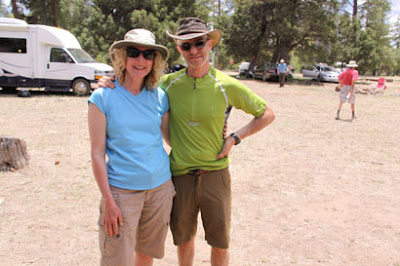
Here's our "after" photo. Looking pretty happy, considering! And waving the Salomon flag once again.
We finished with 1390 pts, 4th of 7 teams in our category. Surprisingly, we were only 10 pts behind 3rd place, and we passed up some easy low value controls near the end because we figured we were totally out of the competition. In fact, winning was never a possibility. The top Veteran Coed team (I'd picked them for the win based on Google) got 2750 pts, about 1000 pts ahead of 2nd place and only 10 pts behind the Male team that won overall. Wow.
Ray and Terri Kitowski of GHO not only kicked our butts with their 1670 pts - they beat out all the other Super Veteran Coed teams to be named North American Champions. Congratulations!
Although this was clearly a bad result for us - the worst rogaine we've ever done - I'm not feeling down about it. We race a lot. In the past 8 weeks, we've done the Rock & Ice Ultra, Giant's Rib Raid, Boston Marathon (Richard), Frontier Adventure Challenge and the Mogollon Rim Rogaine. This was the only competitive disaster. If you do enough races, some of them will go badly. There were a lot of positives about this event:
- The first 8 hrs went really well. I think our planned sequence of controls for the 24 hrs was a good one if it had been executed properly.
- In spite of heat, exertion, sleep deprivation and altitude, I never felt faint, and I'd been worried about that.
- Richard and I had fun together.
- I ate and drank more than usual. I discovered that a wee can of Starbucks espresso is the perfect midnight snack.
- I used most of the stuff in my pack - I was less overpacked than usual.
- It was a beautiful place to trek around for 24 hrs.
- Even with the altitude and heat, it didn't seem physically difficult - except going up those canyon walls!
- It was a well-designed course, and the menu for the post-race food was extensive and varied.
- It gave us an excuse for a fun vacation in Arizona!
- It was nice to see some familiar faces - people I like and respect, but don't often see in real life.
We need to do more analysis to see what lessons we can take away. A few thoughts so far:
- Set a deadline time by which I need to choose the basic outline of my route, i.e. a time to stop trying to optimize it any further and switch to detailed analysis of a particular route.
- Write a list of all the things that need to be done in that last hour before the race, and post it in an obvious place - it would include things like changing my glasses, writing down control sequence on waterproof paper, setting up the map cases, etc.
- As soon as a road starts doing something funny, switch to using bearings and distance estimation. Don't be pathetically hopeful and give the road a second chance.
- Do more rogaines. Get our mojo workin' again! :-)
So to recap... at the end of Day 1, I'd decided to switch to a more conservative route for the rest of the night. Looking at the map now, I can see no reason to do this - I'd simply lost confidence after our experience leaving the canyon. I blamed myself for not finding the trail, and my sleep-deprived mind convinced me that I would have trouble finding things from now on. The silly thing is, I'd already had no trouble finding two controls on the east side of the canyon after our climb. I woke Richard from his nap, and we headed out. He'd been following the map closely in the daylight, but between sleepmonsters and the canyon confusion, he was pretty much finished with navigating.
We picked up three controls along our new road route. Two of them went smoothly; on the third, we lost time after heading down the wrong spur to look for a re-entrant. No biggie - it's a long race. Up to this point, the mapped roads continued to be as useful as they had been all day. I pace counted and watched my compass on the roads, and it was easy to keep track of the main roads and ignore the unmapped minor roads. But then (dramatic organ chord) we entered an area where loggers had been at work, and our road started misbehaving. It was supposed to go north, but it only wanted to go east, and I assumed that the north-south road on my map no longer continued north of its intersection with this east-west road, which appeared on the map. I took a bearing toward a control from where I thought we were. Within 300 meters, we'd hit another good east-west road. Crap. We weren't that far from the edge of the map, so now I was uncertain and afraid to take risks.
We started walking east on the road, since that would lead us to the main north-south forest road if we failed to be struck by any insights enroute. Eventually the road started making turns exactly like a road on the map. Even better, I could prove my hypothesis by finding a control in a shallow re-entrant just a few hundred meters away. We headed down and didn't see a flag - just a pair of large eyes staring at us from about 50 m away at bear height. (We'd seen a few elk during the day, but they are taller.) We convinced ourselves rather quickly that we had done a thorough search for the control, returning to our mystery road feeling discouraged. Ironically, we were exactly where I thought we were - but now we thought we weren't. Later on, when we approached that control from a different direction, we saw that it had been hiding behind Mr. Bear Eyes. But in the meantime, we were still in damage control mode - not racing, just trying to relocate so we could begin racing again.
That happened just before morning, and we found a few more controls after that. Unfortunately, we weren't very effective by then - distracted by painful blisters on the soles of our feet, unseasonably hot weather, sleepiness and frustration with our poor performance. If I didn't see it firsthand, I'd find it pretty much unbelievable that we could get as few points in the second part of the rogaine as we did. We scored 940 pts in the first 8 hrs and 450 pts in the final 16 hrs! After we'd wasted too much time on a couple of fruitless searches from inaccurate attackpoints in the hot morning sun, I pulled the plug and told Richard I wanted to hobble back to the Hash House, about 90 minutes away. It felt like I was walking on broken glass, and it was BOILING hot. (Arizona was having a heat wave - it's not normally this bad in May.) Richard was faster as always, but the soles of his feet were hurting too.
Although our race had been a bust from a competitive standpoint, the Arizona flora, fauna and scenery still made the rogaine well worth it.
Here's our "after" photo. Looking pretty happy, considering! And waving the Salomon flag once again.
We finished with 1390 pts, 4th of 7 teams in our category. Surprisingly, we were only 10 pts behind 3rd place, and we passed up some easy low value controls near the end because we figured we were totally out of the competition. In fact, winning was never a possibility. The top Veteran Coed team (I'd picked them for the win based on Google) got 2750 pts, about 1000 pts ahead of 2nd place and only 10 pts behind the Male team that won overall. Wow.
Ray and Terri Kitowski of GHO not only kicked our butts with their 1670 pts - they beat out all the other Super Veteran Coed teams to be named North American Champions. Congratulations!
Although this was clearly a bad result for us - the worst rogaine we've ever done - I'm not feeling down about it. We race a lot. In the past 8 weeks, we've done the Rock & Ice Ultra, Giant's Rib Raid, Boston Marathon (Richard), Frontier Adventure Challenge and the Mogollon Rim Rogaine. This was the only competitive disaster. If you do enough races, some of them will go badly. There were a lot of positives about this event:
- The first 8 hrs went really well. I think our planned sequence of controls for the 24 hrs was a good one if it had been executed properly.
- In spite of heat, exertion, sleep deprivation and altitude, I never felt faint, and I'd been worried about that.
- Richard and I had fun together.
- I ate and drank more than usual. I discovered that a wee can of Starbucks espresso is the perfect midnight snack.
- I used most of the stuff in my pack - I was less overpacked than usual.
- It was a beautiful place to trek around for 24 hrs.
- Even with the altitude and heat, it didn't seem physically difficult - except going up those canyon walls!
- It was a well-designed course, and the menu for the post-race food was extensive and varied.
- It gave us an excuse for a fun vacation in Arizona!
- It was nice to see some familiar faces - people I like and respect, but don't often see in real life.
We need to do more analysis to see what lessons we can take away. A few thoughts so far:
- Set a deadline time by which I need to choose the basic outline of my route, i.e. a time to stop trying to optimize it any further and switch to detailed analysis of a particular route.
- Write a list of all the things that need to be done in that last hour before the race, and post it in an obvious place - it would include things like changing my glasses, writing down control sequence on waterproof paper, setting up the map cases, etc.
- As soon as a road starts doing something funny, switch to using bearings and distance estimation. Don't be pathetically hopeful and give the road a second chance.
- Do more rogaines. Get our mojo workin' again! :-)
Saturday May 16, 2009 #
Event: Mogollon Rim Rogaine
Orienteering race 13:00:00
2009 North American Rogaining Champs - Mogollon Rim - Day 1
Hard to believe this was my 4th North Am Rogaining Championship already, and my first one racing with my husband and adventure racing teammate Richard. Andrea, Nina and Leanne were excellent partners on female teams in the past 3 championships in British Columbia, New York and Quebec respectively, and we were fortunate to win our category, but I had no illusions that my luck would carry over to the competitive Veteran Coed division.

After my fainting-in-the-woods episode two weeks ago, I was a little uneasy. I'm going to see my doc after passing out during a 30-minute run on a 21C day, but this weekend I planned to be in the woods for 24 hrs at an altitude of 7,500' and 30C for much of the day. Hmm.
We had 2 hours with the map before the race started.

Normally when I get a rogaine map, I'm able to quickly identify a few controls or map areas to ignore because the reward isn't sufficient for the effort. Similarly, there is often a cluster or spine of high-value controls that leap off the page as the best choice to build my route around. Not so this time. John Maier designs great rogaines, and no matter where I moved my distance-measuring string, our points totalled about the same. I ended up wasting too much time looking for the best route when my time would have been better spent fine-tuning any one of the routes I'd considered.
The big decision was whether to cross the 600' deep Chevalon Canyon on the west side of the map. I considered leaving it out entirely, a strategy that worked well for Team Beautiful Hair. On the plus side, that part of the map held 900 of the possible 3440 points, with high-value controls placed a little more densely than in other areas of the map. Controls were all on easy-to-find features with good attackpoints nearby. There were long roads, ridges and valleys to use as handrails with relatively easy walking. (In retrospect, a perfect place to be at night.) We saw two negatives - the 600' climb/descent in each direction on a hot day at altitude, and our estimate that darkness would fall just as we reached the bottom of the canyon on our way back. We decided to go for it - we don't mind climbing, and there was a trail marked at the location where we planned to climb out of the canyon in the dark.
By the time we'd finally settled on the first 75% of our route (leaving the end flexible), there was little time left to document our route choice, set up our map cases properly and so on. We started racing at 11 a.m. in oppressive heat, and I quickly realized that my vision had gone blurry. Eeek! Luckily, this wasn't a southern version of Cathy G's frozen corneas - I'd been so rushed that I'd forgotten to trade my reading glasses for sunglasses. I had the sunglasses with me, so made a quick change.
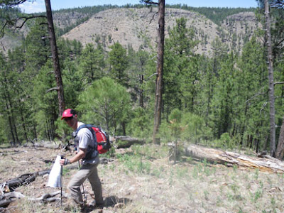
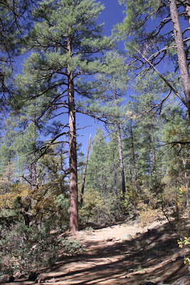
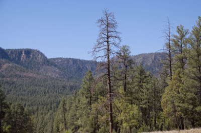
Much of the terrain looked like this open Ponderosa pine forest - really nice to move through. Some areas were rockier, steeper and/or thicker, but this was common.

We picked up two controls, then descended a steep spur into Chevalon Canyon. There were 3 controls along the river.

We took them from south to north. Along the way, we met a male team who advised us to "watch out for the snakes" if we were "going that way". They were unspecific, and I've since wondered if they were playing mind games, but I started watching more closely for rattlers after that. Apparently some other teams saw and heard them. (Snakes, that is. Not the two guys.)
We climbed up a spur on the west side of the canyon at #86. It was long and steep, but not technical.

We decided to do everything over there except #58. We ran into Eric & Mary Smith a couple of times, and also met Sharon Crawford and her brother. I was glad to see that others were building their first day around this part of the map.

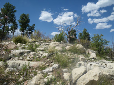
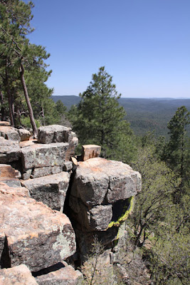
A few of the controls were on spurs on the western rim of the canyon - beautiful views. Note the first photo looking back toward the rugged eastern wall of the canyon. (Foreshadowing!!)
--
--

I don't think I would have changed anything in the first 8 hours of the rogaine. We spiked the controls, I drank way more than I usually do, Richard was strong as always, the scenery was gorgeous, and I survived the heat even if I didn't enjoy it. We had 940 points at sunset, and using Jim Waddington's Rogaining Rule of Thumb #5 (or so), our total score should end up approximately double that amount, i.e. 1880 pts in 24 hrs. We were optimistic, given that we still had 16 hrs of racing left when the sun went down, and our race had been going so smoothly. As the sun set, the air felt deliciously cool, and I looked forward to a productive night.

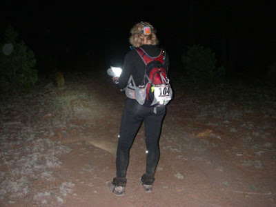
But that's not how it went. We'd estimated that complete darkness would fall at the bottom of Chevalon Canyon on our return crossing. We got to the bottom of the canyon using a fishing trail, then we skirted the southwest shore of the lake just using our night vision before pulling out headlamps. No problem - now we just needed to find the nearby Weimer Ridge Trail. But Richard and I couldn't agree on the point where the narrow lake turned into a wide creek (the lake is dammed at the other end), so our attackpoint was flimsy. The course setter had said that the trail wasn't super-obvious, but from the map, I hadn't anticipated problems identifying the south tip of the lake.
The mapped trail appeared to weave through the cliffs. We weren't sure if we could get up any other way in this part of the canyon, especially in the dark, so we spent far too long looking for the trail. In a photo taken earlier on the west side, here's a reminder of what the 600' canyon wall looks like. Note the band of cliffs near the top.

Finally we decided to just climb straight up. (Turns out we didn't meet anyone who located the trail, day or night, from the top or from the bottom.) It was a long, tough climb, and we had to scramble up a few small cliffy areas, which felt sketchy and nervewracking. But we made it up, and in a 24-hr event, you can waste an hour and still do OK.
However, the climb had been difficult physically and mentally, and I'd lost my confidence from earlier in the day. We found our next two controls with no problem, then stopped for our "dinner" break - pizza, a change of socks, warmer shirt. I pulled out the map and proceeded to ruin our race...
I decided to make things easier for the night, adjusting our route to attack a series of medium-value controls from obvious points along roads. The controls weren't that different from what we'd planned, but we would be taking longer, "safer" routes with less climbing/descending and less mental focus required. We'd heard that some roads on the map were a little off and that other unmapped roads existed, but up to this point, they had been easy to figure out, so I was lulled into a false sense of security. Oops.
Hard to believe this was my 4th North Am Rogaining Championship already, and my first one racing with my husband and adventure racing teammate Richard. Andrea, Nina and Leanne were excellent partners on female teams in the past 3 championships in British Columbia, New York and Quebec respectively, and we were fortunate to win our category, but I had no illusions that my luck would carry over to the competitive Veteran Coed division.
After my fainting-in-the-woods episode two weeks ago, I was a little uneasy. I'm going to see my doc after passing out during a 30-minute run on a 21C day, but this weekend I planned to be in the woods for 24 hrs at an altitude of 7,500' and 30C for much of the day. Hmm.
We had 2 hours with the map before the race started.
Normally when I get a rogaine map, I'm able to quickly identify a few controls or map areas to ignore because the reward isn't sufficient for the effort. Similarly, there is often a cluster or spine of high-value controls that leap off the page as the best choice to build my route around. Not so this time. John Maier designs great rogaines, and no matter where I moved my distance-measuring string, our points totalled about the same. I ended up wasting too much time looking for the best route when my time would have been better spent fine-tuning any one of the routes I'd considered.
The big decision was whether to cross the 600' deep Chevalon Canyon on the west side of the map. I considered leaving it out entirely, a strategy that worked well for Team Beautiful Hair. On the plus side, that part of the map held 900 of the possible 3440 points, with high-value controls placed a little more densely than in other areas of the map. Controls were all on easy-to-find features with good attackpoints nearby. There were long roads, ridges and valleys to use as handrails with relatively easy walking. (In retrospect, a perfect place to be at night.) We saw two negatives - the 600' climb/descent in each direction on a hot day at altitude, and our estimate that darkness would fall just as we reached the bottom of the canyon on our way back. We decided to go for it - we don't mind climbing, and there was a trail marked at the location where we planned to climb out of the canyon in the dark.
By the time we'd finally settled on the first 75% of our route (leaving the end flexible), there was little time left to document our route choice, set up our map cases properly and so on. We started racing at 11 a.m. in oppressive heat, and I quickly realized that my vision had gone blurry. Eeek! Luckily, this wasn't a southern version of Cathy G's frozen corneas - I'd been so rushed that I'd forgotten to trade my reading glasses for sunglasses. I had the sunglasses with me, so made a quick change.
Much of the terrain looked like this open Ponderosa pine forest - really nice to move through. Some areas were rockier, steeper and/or thicker, but this was common.
We picked up two controls, then descended a steep spur into Chevalon Canyon. There were 3 controls along the river.
We took them from south to north. Along the way, we met a male team who advised us to "watch out for the snakes" if we were "going that way". They were unspecific, and I've since wondered if they were playing mind games, but I started watching more closely for rattlers after that. Apparently some other teams saw and heard them. (Snakes, that is. Not the two guys.)
We climbed up a spur on the west side of the canyon at #86. It was long and steep, but not technical.
We decided to do everything over there except #58. We ran into Eric & Mary Smith a couple of times, and also met Sharon Crawford and her brother. I was glad to see that others were building their first day around this part of the map.
A few of the controls were on spurs on the western rim of the canyon - beautiful views. Note the first photo looking back toward the rugged eastern wall of the canyon. (Foreshadowing!!)
--
--
I don't think I would have changed anything in the first 8 hours of the rogaine. We spiked the controls, I drank way more than I usually do, Richard was strong as always, the scenery was gorgeous, and I survived the heat even if I didn't enjoy it. We had 940 points at sunset, and using Jim Waddington's Rogaining Rule of Thumb #5 (or so), our total score should end up approximately double that amount, i.e. 1880 pts in 24 hrs. We were optimistic, given that we still had 16 hrs of racing left when the sun went down, and our race had been going so smoothly. As the sun set, the air felt deliciously cool, and I looked forward to a productive night.
But that's not how it went. We'd estimated that complete darkness would fall at the bottom of Chevalon Canyon on our return crossing. We got to the bottom of the canyon using a fishing trail, then we skirted the southwest shore of the lake just using our night vision before pulling out headlamps. No problem - now we just needed to find the nearby Weimer Ridge Trail. But Richard and I couldn't agree on the point where the narrow lake turned into a wide creek (the lake is dammed at the other end), so our attackpoint was flimsy. The course setter had said that the trail wasn't super-obvious, but from the map, I hadn't anticipated problems identifying the south tip of the lake.
The mapped trail appeared to weave through the cliffs. We weren't sure if we could get up any other way in this part of the canyon, especially in the dark, so we spent far too long looking for the trail. In a photo taken earlier on the west side, here's a reminder of what the 600' canyon wall looks like. Note the band of cliffs near the top.
Finally we decided to just climb straight up. (Turns out we didn't meet anyone who located the trail, day or night, from the top or from the bottom.) It was a long, tough climb, and we had to scramble up a few small cliffy areas, which felt sketchy and nervewracking. But we made it up, and in a 24-hr event, you can waste an hour and still do OK.
However, the climb had been difficult physically and mentally, and I'd lost my confidence from earlier in the day. We found our next two controls with no problem, then stopped for our "dinner" break - pizza, a change of socks, warmer shirt. I pulled out the map and proceeded to ruin our race...
I decided to make things easier for the night, adjusting our route to attack a series of medium-value controls from obvious points along roads. The controls weren't that different from what we'd planned, but we would be taking longer, "safer" routes with less climbing/descending and less mental focus required. We'd heard that some roads on the map were a little off and that other unmapped roads existed, but up to this point, they had been easy to figure out, so I was lulled into a false sense of security. Oops.
Friday May 15, 2009 #
Trekking 2:00:00 [1]
Richard and I did some hiking today - as if 24 hrs on our feet this weekend isn't going to be enough! Our main hike was a gentle climb along Horton Creek.

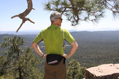
Then we went up to Rim Road and did some walking around Bear Canyon Lake and the edge of the Mogollon Rim - the only time we'll ever out-navigate Peter G, who apparently did not find the Rim on the hike he did with Barb today.

Pete will be glad to see this pic of a loyal Salomon customer.
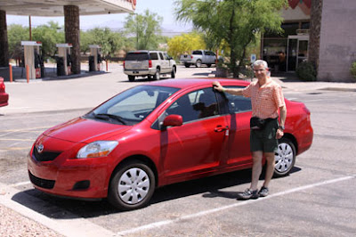
We drove to the rogaine site, including half an hour of slow, bumpy forest roads. We arrived almost an hour after registration was scheduled to open, but the packets hadn't arrived yet, and the promised maps from previous events were not posted. Oh well, we drove back down the bumpy forest roads and headed to our cabin, almost an hour away. Glad the Yaris is easy on gas. We ate a big dinner, finished assembling our packs and got to bed at a reasonable hour. (It doesn't hurt that our bodies still think it's 3 hrs later.)
Then we went up to Rim Road and did some walking around Bear Canyon Lake and the edge of the Mogollon Rim - the only time we'll ever out-navigate Peter G, who apparently did not find the Rim on the hike he did with Barb today.
Pete will be glad to see this pic of a loyal Salomon customer.
We drove to the rogaine site, including half an hour of slow, bumpy forest roads. We arrived almost an hour after registration was scheduled to open, but the packets hadn't arrived yet, and the promised maps from previous events were not posted. Oh well, we drove back down the bumpy forest roads and headed to our cabin, almost an hour away. Glad the Yaris is easy on gas. We ate a big dinner, finished assembling our packs and got to bed at a reasonable hour. (It doesn't hurt that our bodies still think it's 3 hrs later.)
Thursday May 14, 2009 #
Note
Off to the Mogollon Rim Rogaine - the 2009 North American Champs. Keen to maximize our time in Arizona, I'd booked an early flight - totally forgetting that they aren't on Daylight Savings Time. It turned out that Richard and I had to get up at 1:15 a.m. Arizona time to catch our plane. Great preparation for a 24-hr event!
At the Phoenix airport, we were reminded of friends far away.

Other friends weren't far away at all. In fact, on the next escalator over, I thought I recognized the back of Barb's head ("Attackpoint Barb", as we call her to avoid confusion). I tried calling her name, and sure enough, she turned around. Then Peter G materialized a few steps higher. They are racing with Cristina on Team Beautiful Hair - a team with a scary amount of navigation talent and three of the most entertaining logs on Attackpoint - if you like to read well-written slices of life sprinkled with insightful comments, humour, photos, maps, drawings, video and links.

We picked up our cute, gas-sipping Toyota Yaris and headed for Payson, the last large town before the rogaine site (near Forest Lakes).
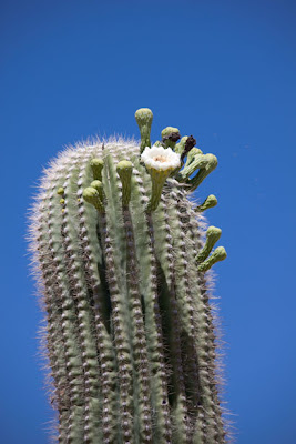
The Sonoran Desert was gorgeous with cacti in bloom. It was really, *really* hot. It turns out that Arizona is having a heat wave. Hmm, I fainted at 21C a couple of weeks ago, and now I'm going to be racing at 30C. Wish me good luck with that!


After a yummy Mexican lunch in Payson, we loaded up on provisions. One of the things I love about the U.S. is the unusual snack foods you can find at convenience stores. Today's discovery was "Pickle in a Pouch" - a big dill pickle in a thick plastic bag, sitting in about 200 ml of brine. It comes in multiple flavours (e.g. "Garlic Gus", "Big Mama") and weighs a ton - it didn't make the cut in my pre-rogaine shopping.
We headed partway up the Mogollon Rim, stopping at Wooden Nickel Cabins in Christopher Creek. This area looks totally different from the earlier part of our drive - almost like Canada.
An exercise physiologist once told me that if you can't acclimatize to altitude for the better part of a week before an event, then you should just sail in and race before your body starts making adaptations. Supposedly, we tend to be at our worst physically around the 3rd day at altitude. So I booked a place within an hour of the rogaine site, but about 350 meters lower. Our 2-storey cabin was beautiful - wood interior, living room, kitchen, back patio with BBQ - and the National Forest was right out the back door. There wasn't much else out there though, which is why we needed to stock up on groceries!
Richard and I went for a short hike to get a feel for the ponderosa pine forests - and of course I had to hug a tree.

We met a friendly fellow on an ATV who told us that he was hosting a youth turkey hunting camp this weekend. Just our luck! We thought we'd left the turkey hunters behind in Palgrave, but now we get to share the forest with kids carrying guns. Yeehaw!
At the Phoenix airport, we were reminded of friends far away.
Other friends weren't far away at all. In fact, on the next escalator over, I thought I recognized the back of Barb's head ("Attackpoint Barb", as we call her to avoid confusion). I tried calling her name, and sure enough, she turned around. Then Peter G materialized a few steps higher. They are racing with Cristina on Team Beautiful Hair - a team with a scary amount of navigation talent and three of the most entertaining logs on Attackpoint - if you like to read well-written slices of life sprinkled with insightful comments, humour, photos, maps, drawings, video and links.
We picked up our cute, gas-sipping Toyota Yaris and headed for Payson, the last large town before the rogaine site (near Forest Lakes).
The Sonoran Desert was gorgeous with cacti in bloom. It was really, *really* hot. It turns out that Arizona is having a heat wave. Hmm, I fainted at 21C a couple of weeks ago, and now I'm going to be racing at 30C. Wish me good luck with that!
After a yummy Mexican lunch in Payson, we loaded up on provisions. One of the things I love about the U.S. is the unusual snack foods you can find at convenience stores. Today's discovery was "Pickle in a Pouch" - a big dill pickle in a thick plastic bag, sitting in about 200 ml of brine. It comes in multiple flavours (e.g. "Garlic Gus", "Big Mama") and weighs a ton - it didn't make the cut in my pre-rogaine shopping.
We headed partway up the Mogollon Rim, stopping at Wooden Nickel Cabins in Christopher Creek. This area looks totally different from the earlier part of our drive - almost like Canada.
An exercise physiologist once told me that if you can't acclimatize to altitude for the better part of a week before an event, then you should just sail in and race before your body starts making adaptations. Supposedly, we tend to be at our worst physically around the 3rd day at altitude. So I booked a place within an hour of the rogaine site, but about 350 meters lower. Our 2-storey cabin was beautiful - wood interior, living room, kitchen, back patio with BBQ - and the National Forest was right out the back door. There wasn't much else out there though, which is why we needed to stock up on groceries!
Richard and I went for a short hike to get a feel for the ponderosa pine forests - and of course I had to hug a tree.
We met a friendly fellow on an ATV who told us that he was hosting a youth turkey hunting camp this weekend. Just our luck! We thought we'd left the turkey hunters behind in Palgrave, but now we get to share the forest with kids carrying guns. Yeehaw!
Trekking 30:00 [1]
Hike in the National Forest near Hunter Creek
Wednesday May 13, 2009 #
Note
Leaving for the North Am Rogaine Champs early tomorrow. Looks like limited Internet access, but I'll post race report and photos next week. Have a great holiday weekend, everyone!
Tuesday May 12, 2009 #
Note
It's going to be fun receiving communications for BAMM, the Swedish mountain marathon we're doing. Here's what we learned today:
"At the finish line the participants will be shouted a hamburger and drink."
Note to 'Bent: It sounds like Swedes may not be into vegetarianism. Carbon, is that true?
"At the finish line the participants will be shouted a hamburger and drink."
Note to 'Bent: It sounds like Swedes may not be into vegetarianism. Carbon, is that true?
Note
Over a 5-minute period this evening, I looked out our window to see:
- 3 wild turkeys
- 2 baby raccoons
- 1 young deer
No partridge, no pear tree. But it's been another one of those Disney movie evenings... (pause to burst into song...)
- 3 wild turkeys
- 2 baby raccoons
- 1 young deer
No partridge, no pear tree. But it's been another one of those Disney movie evenings... (pause to burst into song...)
Monday May 11, 2009 #
Mountain Biking (3 hrs elapsed) 1:45:00 [2]
Rode version 4 of the Mansfield MTB-O course, hanging ribbons and making course revisions as I went along. The other course setter was supposed to be there, but he got called in to work, so I kept my fingers crossed that the dizziness wouldn't return - and it didn't. Good thing too, since the one key item I forgot was my compass, so I needed to stay sharp.
Mansfield has a marvelous trail system for MTB-O, but now that it is closed to the public for mountain biking, some single track is maintained (mostly by Chico Racing) and other minor trails are not. So I really needed to ride it to see what would work - I couldn't just look at the map. I also encountered an unexpected landowner issue in the SE corner of the map, so had to switch some things around. It's been complicated to pull together, but I think it's going to be a fun event. Be there! :-)
http://caledonnavigators.heysport.com/