Training Log Archive: BashIn the 7 days ending May 3, 2009:
| ||||||||||||||||||||||||||||||||||||||||||||||||||||||||||||||||||
| « | » |
| » now | ||||||||||
| Mo | Tu | We | Th | Fr | Sa | Su | |||||||
Sunday May 3, 2009 #
Trekking 20:00 [2]
'Bent and I staffed a remote CP for the high school adventure challenge. All but three of the 60+ teams passed by in 50 busy minutes. Shifty was a roving observer nearby. Gorgeous day, excited kids, beautiful woods and some friendly visitors from the adult race. Great way to spend a sunny day!
Saturday May 2, 2009 #
Adventure Racing race 5:36:00 **
Frontier Adventure Challenge - Deerhurst
First summer adventure race of 2009! Since I'd "trained" by doing completely different things for the past 6 months, I wondered how much my body would rebel. 'Bent and I carpooled with Leanimal, Goose and Shifty. Five bikes, five people, great conversation, and tons of gear in and on the Bullfrog van.

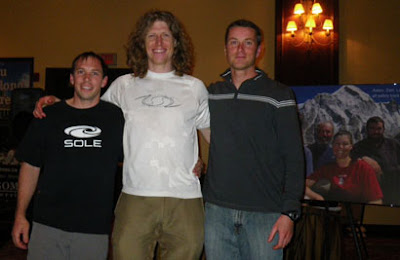
We were excited to drag Shifty (Mike) Schaffel out of retirement to join the Tree Huggers for this event. Shifty and I raced together several years ago with the Terranauts, and I knew he'd be a great fit for our team.

We got the maps at 7 a.m. This was our 4th race around Deerhurst, and we recognized some familiar terrain. No problem - it was a terrific spring day, and we didn't mind seeing a few lakes and trails we'd seen before.
Warning: If you weren't there, you'll probably find this report too long and boring.
I could see that CPs 4 (depending on route choice) and 8 would be a bit of a crapshoot. The best way to avoid this problem is for the race designer to set the course using only map and compass, and choose mapped features as CPs - or unique locations closely related to mapped features. And the control descriptions should be very specific. As a final step, if the course isn't going to be marked on the map (thus avoiding a big, easily avoidable source of error), the CPs can be GPSed and checked against the mapped features to ensure that the UTMs will cause no confusion. The reason I expected people to have problems with these CPs was that they relied on UTMs on unmapped features - although there was a longer, more reliable route to CP4 if teams ignored the race instructions on how to get there. (Which few teams did.)
We started off on our bikes, heading toward the Muskoka River that flows from the southwest corner of Fairy Lake. We had 10K of fun riding - rolling hills on mostly dirt road. Our troubles for the day began when Shifty's bike refused to shift on the uphills - a problem that plagued it for the rest of the race. Then in the middle of one of the biggest, steepest downhills, I hit a huge bump, and my map flew from the bike map holder (which wasn't completely closed) and landed in the middle of the road. As the next two teams whizzed past, I dove into the dirt to rescue the map while apologizing profusely to them at the top of my lungs.
After transitioning to the paddle, we found ourselves sitting surprisingly low in the water, given our team's small stature, and the canoe was very short. We had to be cautious about hitting kayak paddles, whacking people's heads, and - worst of all - tipping into the cold water on a breezy day. In spite of our tenuous balance, our Trayling training kicked in. The three of us had spent many 6 a.m. hydrospinning classes together. We passed 4 teams and caught a few more as we paddled across Fairy Lake and through the canal back to Deerhurst. From there, we ran back to the main transition area to start the trek.
I was surprised we got the infamous "cartoon map" from last year's race - the Deerhurst hiking map with skewed 3D perspective that I had liked, but most people detested. This time it was only provided as extra information to help understand the 1:50,000 topo map, and I think most people would agree that it was useful.
I'd decided to just ignore the trail system and take a bearing toward CP3, which was a pond on a golf fairway. We came out too far east on the fairway and wasted some time checking further east to make sure that the pond downhill to our west was the right one, since I didn't think I could have gone that far off my bearing. Also, we'd been told that the map didn't match the ponds. It wasn't enough to just look for a CP flag, since we'd been warned that the flags for the high school race were already out. It turned out to be the pond we'd first seen to the west, and I beat myself up for falling off my bearing, but the next day Dave Zietsma ran the course and changed the UTM for the high school race. Turns out I'd followed the correct bearing, but the UTM was incorrect - PhattyJR ended up too far east as well.
We crossed Hwy 60 to the airfield and ran along the runway. In retrospect, given the way the race ended for us, all I can say is that we'd better *really* enjoy the fun photos we took along the way! :-)

From here, the instructions directed us to enter a trail network and locate a trail that started roughly at a UTM that wouldn't be easily recognizable in the terrain. As I'd expected, some teams got quite lost in this section. We chose one trail and followed it for a minute before abandoning it because it turned too far west. Shifty is a cameraman for "Mantracker" and had filmed a show in the area. He remembered a north-south trail in the area with a steep hill, and I was looking for one with a "D102" snowmobile trail sign (from the Backroads Map Book). A few minutes further east, we came upon a very steep trail with a D102 sign on it. Yay.
From there, it was about 2 km of following a mucky snowmobile trail through beautiful woods. We encountered some trail junctions, but it was possible to follow the major ups and downs of the terrain on the map and figure out where we were, even though no trails were marked. We ran a little, but Shifty fell back, and we noticed him touching his legs, looking confused. Finally, at the top of a hill, he announced that his feet had gone completely numb. Yikes! Luckily, he guessed the right solution - he removed new bike shorts he was wearing over his tights, and the blood returned to his feet and legs, restoring him to top notch Shifty-shape within a few minutes.

At CP4 ("high point on trail not shown"), we met Leanimal and Goose, who rang cowbells to cheer us on! This earned them the Most Spirited CP Award.

Less than a kilometer later, we popped out onto a road where we picked up our bikes. Apparently we were lucky, since the landowner showed up later and freaked out about all the adventure racers passing through his property. Hopefully, Leanimal will share the story in her log. After a major scene, there was an emergency re-route to a neighbouring property, and some of the later teams just went to CP5 without getting CP4.
[Edit: OK, here's Leanimal's excellent report.
http://www.attackpoint.org/viewlog.jsp/user_2521/p...]
We rode our bikes downhill and along a dirt road to the Dyer Memorial, where I think FB sent us in a Raid The North a few years ago. We dropped our bikes at the parking lot, and Geoff looked happy to see us, since he was expecting more teams by now. I was pretty sure they were still looking for CP4!
We went up to the memorial (CP7), then headed for CP8, a classic bingo control - junction of 3 trails, all unmarked, in a bland area. I decided to go up the ridge to the west of the memorial, gambling on finding a north-south trail that might become one of the three trails I needed. If that failed, the UTM was depicted as being due north of where the ridge dropped down, so I hoped that following the ridge would take me to an east-west trail that would be one of the three trails. If that failed, I had nothing - other than wandering around on trails, which I later heard was a popular way of finding CP8. We did find a trail on the ridge eventually, but there had been some nasty blowdown in the forest, so it wasn't easy getting there. The trail dropped us out on an east-west trail, so everything was going according to my pseudo-plan - except for the lack of a CP flag. We went a short distance west and saw other teams looking for it. After 2 minutes, it felt too far, so we turned back east and found the flag at the next trail junction east of the one where we'd come off the ridge. Phew.
Now it was time for the advanced trekking CP on an island in the Big East River. We mostly bushwhacked on a bearing until we reached the edge of a steep valley where a creek ran into the river. We skidded down the slope clinging to saplings and started to bushwhack along the creek, then quickly abandoned the idea because of the nasty, thick shrubs and deep water. We climbed a short distance back up the ridge and headed south toward the river, which was our real goal. I was thinking that we'd cross the creek closer to the river, but Shifty remembered a road running along the river, and sure enough, we hit it right at the point where it crossed the creek, so we were spared the full immersion that some teams experienced further upstream. Shifty also remembered a trail to the river on the far side of the bridge, and we ran past it Mantracker-style, making tracks on the muddy road for 20 m, then sneaking back along the grass. This was fun. :-)
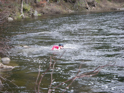
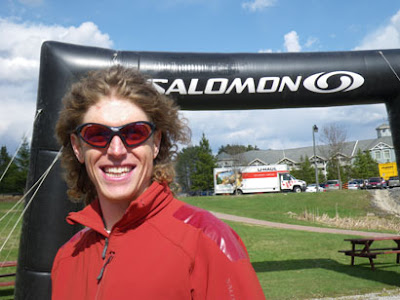
From here, it was a few minutes to the river's edge, and Shifty had bravely volunteered to swim in the cold, rushing current to the island. It was sketchy and would have been worth stationing a volunteer with a throwbag. Kudos to a true sportsman, Tom Martin, for waiting on the island to help Shifty out of the water after his frigid, numbing swim. 'Bent returned the favour when Tom swam back to the mainland. One top racer was almost swept past the island and saved himself by grabbing some vegetation at the downstream end. To our surprise, we saw MBR arriving as we left. Shock - we were leading the coed division!
We ran back to the Dyer Memorial parking lot on dirt roads. Throughout this entire trekking/bushwhacking/running section, I wore my Pearl Izumi cycling shoes with tread, and they rocked. 'Bent was strong, carrying extra weight and towing. Enroute, a small weather system blew through, pelting us with wind and cold rain. Shifty powered on in spite of the chill from his wet clothing. When we got on our bikes, his body finally rebelled from the frigid swim. His legs cramped horribly when he tried to bend them, so it was impossible to even sit on a bike to be towed. For the next 2 km, 'Bent rode his recumbent with one hand and pushed Shifty's bike with the other. Shifty bravely jogged along in cycling shoes on painful legs that wouldn't bend. Eventually, the combination of Tums, E-Caps and warmth kicked in, and his legs started working again. He was able to start riding just before we passed TA3. During this time, MBR passed us. Easy come, easy go.
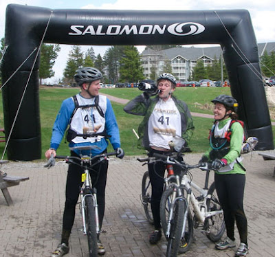
There were three final advanced CPs near Deerhurst that we would reach with a combination of bike and foot. CP11 was on top of a ski hill - great way to warm up. Then CP12 was on a shed that required a little guesswork to locate. We came to it from Hwy 60, and while Shifty was punching, MBR arrived from the golf course side- not sure how we passed them again. Game on! We rode together to the final CP at a bridge, and 'Bent ran up the rocks on Tyson's heels while our teams waited together below. Hmm, a 1.2 km bike sprint finish between Tiny and me. Gee, I wonder how *that's* going to go? ;-)
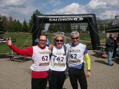
We gave it a good try. It took 'Bent a couple extra seconds to get onto his bike after Tyson had taken off, then he was the only one who had to wait for a car before crossing the main road. We gave it everything we had and crossed the finish line with a big smile about 10 seconds after the very deserving Milton Basement Racers. Given all the challenges we'd faced, we were thrilled to be 2nd Coed and 5th overall of 62 teams, about 50 minutes behind the winners. I also think we were 1st among the teams who stopped to pose for photos along the way, but sadly there wasn't a separate category for that! :-)
MBR got champagne!
Bobkittens were the top female team, as always. Mrs. Gally looked good in leopard skin.

Congrats to PhattyJR, Harper and James for taking the win in a sprint finish. 3rd place male finished just ahead of MBR and us.
Thanks to Hutspot, Goose, Leanimal and all the other hardworking volunteers.

Overall, it was a fun day with two excellent teammates. It was our first time racing all together, but we worked well as a team, with each member making key contributions. I felt reasonably fit, given that I hadn't done much specific training - and our moderate pace kept me feeling fresh. Pre-race, I hadn't thought that my navigation experience would help much in this race, but apparently it did, even though I wouldn't have chosen a couple of the CP locations. At times I felt slightly out of control, relying too much on gut feel because of insufficient information, and I hated that feeling - but it worked out OK in spite of my discomfort. I had some good luck near CP8, and we were also lucky when Shifty recognized a couple of key places from Mantracker. (Although I'm sure he felt unnatural moving through the woods without carrying a 25-lb camera and chasing a horse!) Thanks for a fun day, 'Bent and Shifty!

First summer adventure race of 2009! Since I'd "trained" by doing completely different things for the past 6 months, I wondered how much my body would rebel. 'Bent and I carpooled with Leanimal, Goose and Shifty. Five bikes, five people, great conversation, and tons of gear in and on the Bullfrog van.
We were excited to drag Shifty (Mike) Schaffel out of retirement to join the Tree Huggers for this event. Shifty and I raced together several years ago with the Terranauts, and I knew he'd be a great fit for our team.
We got the maps at 7 a.m. This was our 4th race around Deerhurst, and we recognized some familiar terrain. No problem - it was a terrific spring day, and we didn't mind seeing a few lakes and trails we'd seen before.
Warning: If you weren't there, you'll probably find this report too long and boring.
I could see that CPs 4 (depending on route choice) and 8 would be a bit of a crapshoot. The best way to avoid this problem is for the race designer to set the course using only map and compass, and choose mapped features as CPs - or unique locations closely related to mapped features. And the control descriptions should be very specific. As a final step, if the course isn't going to be marked on the map (thus avoiding a big, easily avoidable source of error), the CPs can be GPSed and checked against the mapped features to ensure that the UTMs will cause no confusion. The reason I expected people to have problems with these CPs was that they relied on UTMs on unmapped features - although there was a longer, more reliable route to CP4 if teams ignored the race instructions on how to get there. (Which few teams did.)
We started off on our bikes, heading toward the Muskoka River that flows from the southwest corner of Fairy Lake. We had 10K of fun riding - rolling hills on mostly dirt road. Our troubles for the day began when Shifty's bike refused to shift on the uphills - a problem that plagued it for the rest of the race. Then in the middle of one of the biggest, steepest downhills, I hit a huge bump, and my map flew from the bike map holder (which wasn't completely closed) and landed in the middle of the road. As the next two teams whizzed past, I dove into the dirt to rescue the map while apologizing profusely to them at the top of my lungs.
After transitioning to the paddle, we found ourselves sitting surprisingly low in the water, given our team's small stature, and the canoe was very short. We had to be cautious about hitting kayak paddles, whacking people's heads, and - worst of all - tipping into the cold water on a breezy day. In spite of our tenuous balance, our Trayling training kicked in. The three of us had spent many 6 a.m. hydrospinning classes together. We passed 4 teams and caught a few more as we paddled across Fairy Lake and through the canal back to Deerhurst. From there, we ran back to the main transition area to start the trek.
I was surprised we got the infamous "cartoon map" from last year's race - the Deerhurst hiking map with skewed 3D perspective that I had liked, but most people detested. This time it was only provided as extra information to help understand the 1:50,000 topo map, and I think most people would agree that it was useful.
I'd decided to just ignore the trail system and take a bearing toward CP3, which was a pond on a golf fairway. We came out too far east on the fairway and wasted some time checking further east to make sure that the pond downhill to our west was the right one, since I didn't think I could have gone that far off my bearing. Also, we'd been told that the map didn't match the ponds. It wasn't enough to just look for a CP flag, since we'd been warned that the flags for the high school race were already out. It turned out to be the pond we'd first seen to the west, and I beat myself up for falling off my bearing, but the next day Dave Zietsma ran the course and changed the UTM for the high school race. Turns out I'd followed the correct bearing, but the UTM was incorrect - PhattyJR ended up too far east as well.
We crossed Hwy 60 to the airfield and ran along the runway. In retrospect, given the way the race ended for us, all I can say is that we'd better *really* enjoy the fun photos we took along the way! :-)
From here, the instructions directed us to enter a trail network and locate a trail that started roughly at a UTM that wouldn't be easily recognizable in the terrain. As I'd expected, some teams got quite lost in this section. We chose one trail and followed it for a minute before abandoning it because it turned too far west. Shifty is a cameraman for "Mantracker" and had filmed a show in the area. He remembered a north-south trail in the area with a steep hill, and I was looking for one with a "D102" snowmobile trail sign (from the Backroads Map Book). A few minutes further east, we came upon a very steep trail with a D102 sign on it. Yay.
From there, it was about 2 km of following a mucky snowmobile trail through beautiful woods. We encountered some trail junctions, but it was possible to follow the major ups and downs of the terrain on the map and figure out where we were, even though no trails were marked. We ran a little, but Shifty fell back, and we noticed him touching his legs, looking confused. Finally, at the top of a hill, he announced that his feet had gone completely numb. Yikes! Luckily, he guessed the right solution - he removed new bike shorts he was wearing over his tights, and the blood returned to his feet and legs, restoring him to top notch Shifty-shape within a few minutes.
At CP4 ("high point on trail not shown"), we met Leanimal and Goose, who rang cowbells to cheer us on! This earned them the Most Spirited CP Award.
Less than a kilometer later, we popped out onto a road where we picked up our bikes. Apparently we were lucky, since the landowner showed up later and freaked out about all the adventure racers passing through his property. Hopefully, Leanimal will share the story in her log. After a major scene, there was an emergency re-route to a neighbouring property, and some of the later teams just went to CP5 without getting CP4.
[Edit: OK, here's Leanimal's excellent report.
http://www.attackpoint.org/viewlog.jsp/user_2521/p...]
We rode our bikes downhill and along a dirt road to the Dyer Memorial, where I think FB sent us in a Raid The North a few years ago. We dropped our bikes at the parking lot, and Geoff looked happy to see us, since he was expecting more teams by now. I was pretty sure they were still looking for CP4!
We went up to the memorial (CP7), then headed for CP8, a classic bingo control - junction of 3 trails, all unmarked, in a bland area. I decided to go up the ridge to the west of the memorial, gambling on finding a north-south trail that might become one of the three trails I needed. If that failed, the UTM was depicted as being due north of where the ridge dropped down, so I hoped that following the ridge would take me to an east-west trail that would be one of the three trails. If that failed, I had nothing - other than wandering around on trails, which I later heard was a popular way of finding CP8. We did find a trail on the ridge eventually, but there had been some nasty blowdown in the forest, so it wasn't easy getting there. The trail dropped us out on an east-west trail, so everything was going according to my pseudo-plan - except for the lack of a CP flag. We went a short distance west and saw other teams looking for it. After 2 minutes, it felt too far, so we turned back east and found the flag at the next trail junction east of the one where we'd come off the ridge. Phew.
Now it was time for the advanced trekking CP on an island in the Big East River. We mostly bushwhacked on a bearing until we reached the edge of a steep valley where a creek ran into the river. We skidded down the slope clinging to saplings and started to bushwhack along the creek, then quickly abandoned the idea because of the nasty, thick shrubs and deep water. We climbed a short distance back up the ridge and headed south toward the river, which was our real goal. I was thinking that we'd cross the creek closer to the river, but Shifty remembered a road running along the river, and sure enough, we hit it right at the point where it crossed the creek, so we were spared the full immersion that some teams experienced further upstream. Shifty also remembered a trail to the river on the far side of the bridge, and we ran past it Mantracker-style, making tracks on the muddy road for 20 m, then sneaking back along the grass. This was fun. :-)
From here, it was a few minutes to the river's edge, and Shifty had bravely volunteered to swim in the cold, rushing current to the island. It was sketchy and would have been worth stationing a volunteer with a throwbag. Kudos to a true sportsman, Tom Martin, for waiting on the island to help Shifty out of the water after his frigid, numbing swim. 'Bent returned the favour when Tom swam back to the mainland. One top racer was almost swept past the island and saved himself by grabbing some vegetation at the downstream end. To our surprise, we saw MBR arriving as we left. Shock - we were leading the coed division!
We ran back to the Dyer Memorial parking lot on dirt roads. Throughout this entire trekking/bushwhacking/running section, I wore my Pearl Izumi cycling shoes with tread, and they rocked. 'Bent was strong, carrying extra weight and towing. Enroute, a small weather system blew through, pelting us with wind and cold rain. Shifty powered on in spite of the chill from his wet clothing. When we got on our bikes, his body finally rebelled from the frigid swim. His legs cramped horribly when he tried to bend them, so it was impossible to even sit on a bike to be towed. For the next 2 km, 'Bent rode his recumbent with one hand and pushed Shifty's bike with the other. Shifty bravely jogged along in cycling shoes on painful legs that wouldn't bend. Eventually, the combination of Tums, E-Caps and warmth kicked in, and his legs started working again. He was able to start riding just before we passed TA3. During this time, MBR passed us. Easy come, easy go.
There were three final advanced CPs near Deerhurst that we would reach with a combination of bike and foot. CP11 was on top of a ski hill - great way to warm up. Then CP12 was on a shed that required a little guesswork to locate. We came to it from Hwy 60, and while Shifty was punching, MBR arrived from the golf course side- not sure how we passed them again. Game on! We rode together to the final CP at a bridge, and 'Bent ran up the rocks on Tyson's heels while our teams waited together below. Hmm, a 1.2 km bike sprint finish between Tiny and me. Gee, I wonder how *that's* going to go? ;-)
We gave it a good try. It took 'Bent a couple extra seconds to get onto his bike after Tyson had taken off, then he was the only one who had to wait for a car before crossing the main road. We gave it everything we had and crossed the finish line with a big smile about 10 seconds after the very deserving Milton Basement Racers. Given all the challenges we'd faced, we were thrilled to be 2nd Coed and 5th overall of 62 teams, about 50 minutes behind the winners. I also think we were 1st among the teams who stopped to pose for photos along the way, but sadly there wasn't a separate category for that! :-)
MBR got champagne!
Bobkittens were the top female team, as always. Mrs. Gally looked good in leopard skin.
Congrats to PhattyJR, Harper and James for taking the win in a sprint finish. 3rd place male finished just ahead of MBR and us.
Thanks to Hutspot, Goose, Leanimal and all the other hardworking volunteers.
Overall, it was a fun day with two excellent teammates. It was our first time racing all together, but we worked well as a team, with each member making key contributions. I felt reasonably fit, given that I hadn't done much specific training - and our moderate pace kept me feeling fresh. Pre-race, I hadn't thought that my navigation experience would help much in this race, but apparently it did, even though I wouldn't have chosen a couple of the CP locations. At times I felt slightly out of control, relying too much on gut feel because of insufficient information, and I hated that feeling - but it worked out OK in spite of my discomfort. I had some good luck near CP8, and we were also lucky when Shifty recognized a couple of key places from Mantracker. (Although I'm sure he felt unnatural moving through the woods without carrying a 25-lb camera and chasing a horse!) Thanks for a fun day, 'Bent and Shifty!
Wednesday Apr 29, 2009 #
Running 15:00 [3]
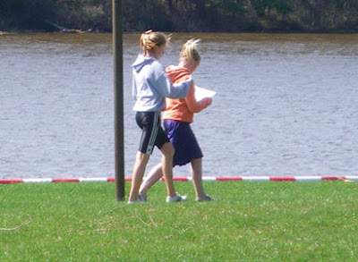
While putting up the final controls for the Hamilton Schools Meet with Laura. This was a terrific day - brilliant sunshine, although with a chilly wind near the lake where I was stationed as a volunteer. I'd been fooled by the 14C forecast and hadn't brought the down jacket that I really needed. Brrr!
As usual, Ray K was the meet organizer extraordinaire. (With wife Terri keeping a close eye on him, undoubtedly for quality control purposes.)

We had almost 800 kids from elementary and high schools racing in teams of two. When they weren't racing, they played soccer, football and frisbee, or they sat on blankets and ate picnics. Some of them were wearing fairly fashionable street clothes to go running. What an awesome school trip!

The kids were excited to check out their results.

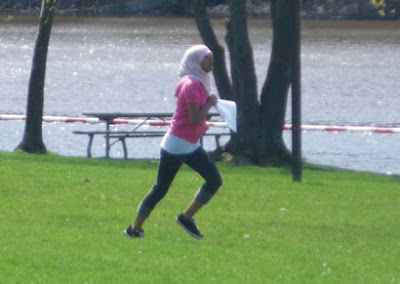
AdventureGirl! and Chloe took the bronze medal in Bantam Girls, which was a HUGE division. Congrats!!

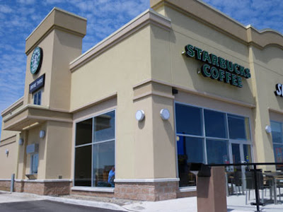
Although it gave me a warm feeling to see the kids enjoying their adventure so much, it wasn't really warm *enough*. I was chilled when I went to my car. I remembered visiting a nearby Dairy Queen after orienteering in the area before, and that didn't sound appealing at all. Imagine my joy (soundtrack: chorus of angels) when I noticed this new business and screeched to a halt. Hot cafe mocha with whipped cream - yesss!!!
As usual, Ray K was the meet organizer extraordinaire. (With wife Terri keeping a close eye on him, undoubtedly for quality control purposes.)
We had almost 800 kids from elementary and high schools racing in teams of two. When they weren't racing, they played soccer, football and frisbee, or they sat on blankets and ate picnics. Some of them were wearing fairly fashionable street clothes to go running. What an awesome school trip!
The kids were excited to check out their results.
AdventureGirl! and Chloe took the bronze medal in Bantam Girls, which was a HUGE division. Congrats!!
Although it gave me a warm feeling to see the kids enjoying their adventure so much, it wasn't really warm *enough*. I was chilled when I went to my car. I remembered visiting a nearby Dairy Queen after orienteering in the area before, and that didn't sound appealing at all. Imagine my joy (soundtrack: chorus of angels) when I noticed this new business and screeched to a halt. Hot cafe mocha with whipped cream - yesss!!!
Tuesday Apr 28, 2009 #
Note
After a seemingly endless tango with Hydro One and OPA since 2005, we have finally been credited $850 for the times our electricity meter has run backwards, feeding power from our solar panels to the grid. Also, we've just received our first cheque under the Standard Offer Contract, paying us for the solar power we have generated since last June. (I signed that contract in Aug. 2007, which gives you some idea of how complex the journey has been.)
Thus we've *finally* got our hydro bill problems sorted out, so yesterday we signed up for Bullfrog Power, the squeaky green electricity that has been powering 'Bent's business for several years. Yahoo - we've been looking forward to this!!!
Hansel, wish you could have been here to join us in the celebration as our house moved a big step closer toward carbon neutrality (solar + geothermal + Bullfrog - yay).
Running (Treadmill) 20:00 [3]
Pathetic, really. Still avoiding the turkey hunters, who were blasting all yesterday morning but kept a low profile today. It appears that none of the nearby neighbours gave permission to hunt on their land, and it's not allowed on conservation land, so we have illegal hunters running around. Joy.
Monday Apr 27, 2009 #
Note
Started the day at 7:30 a.m. with a loud explosion/gunshot sound that seemed to come from right outside the house. I've heard guns go off before, but never as loud as that. I believe the shooter was on our property. I ran outside, freaking out that 'Bent had been shot in the driveway as he prepared to bike to work, but he was as wide-eyed as I was. An hour later, there were a couple of gunshots further away, sounding like they came from the direction of Palgrave West.
Stoopid first day of turkey hunting season... Yes, most hunters are responsible, but based on the number of alcoholic beverage containers left behind at some hunting locations, some of them aren't. And for me, that's a good enough argument to ban hunting with guns in populated areas like this.
Stoopid first day of turkey hunting season... Yes, most hunters are responsible, but based on the number of alcoholic beverage containers left behind at some hunting locations, some of them aren't. And for me, that's a good enough argument to ban hunting with guns in populated areas like this.