Training Log Archive: mgbIn the 7 days ending Jul 31, 2011:
| |||||||||||||||||||||||||||||||||||||||||||||||||||||
| « | » |
| » now | ||||||||||
| Mo | Tu | We | Th | Fr | Sa | Su | |||||||
Sunday Jul 31, 2011 #
10 AM
Running 58:27 [3] 6.51 mi (8:59 / mi) +146m 8:24 / mi
With all the hiking, I chose not to do a long run. Felt pretty good at the end, and could probably have kept going, but didn't want to push it. Wore the anke brace again.
Running warm up/down 8:24 [2] 0.57 mi (14:45 / mi) +36m 12:19 / mi
Saturday Jul 30, 2011 #
10 AM
Running 37:37 [3] 4.13 mi (9:07 / mi) +91m 8:32 / mi
Taking it easy after the grueling days of hiking. I also wore an ankle brace, but the ankle feels relatively good after the run, though tender. I ordered an Active Ankle T2 last night, trying to find a good way to stop turning the ankle ever again but still being physically active.
Thursday Jul 28, 2011 #
8 AM
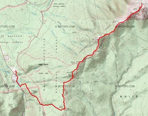
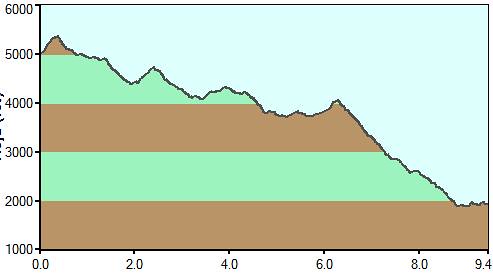
Walking 10:58:34 [2] 9.4 mi (1:10:04 / mi)
We finished the hike with a stellar day. A few puffy clouds and 100+ miles of visability (as reported by the Mt Washington station). We leisurely climbed 4 4000 footers and enjoyed the fantastic view. Still a very long day.
The current list:
Washington 6288 7/27/2011
Adams 5774 7/27/2011
Monroe 5384 7/28/2011
Madison 5367 7/26/2010
Lafayette 5260 9/4/2010
Lincoln 5089 9/4/2010
Moosilauke 4802 7/3/2010
Eisenhower 4780 7/28/2011
Osceola 4338 7/3/2011
Pierce 4310 7/28/2011
East Osceola 4156 7/3/2011
Jackson 4052 7/28/2011
Tecumseh 4003 5/29/2011
Wednesday Jul 27, 2011 #
8 AM
Walking 11:08:06 [2] 7.3 mi (1:31:31 / mi)
I thankfully had tape with me, so after some taping, I could continue on with the hiking. In the future, I have to tape as a precautionary measure, so I never have to repeat the ankle turning.
We had the goal of hiking up three 4000 footers today, but with the amount of rocks, it took a lot longer than we thought. So we ran out of time and had to skip Jefferson. Even with that, we didn't come to the hut until after 8, with just minutes of daylight left. Not that you could see the sun anyway, there was really only about 30 feet of visíbility with rain filled clouds and 50+ mph winds at the summits. So it was all the ingrediants you needed for a stellar day :)
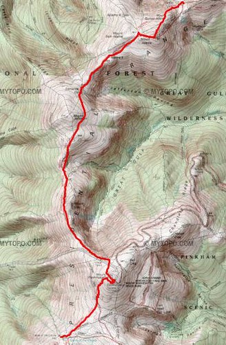
We had the goal of hiking up three 4000 footers today, but with the amount of rocks, it took a lot longer than we thought. So we ran out of time and had to skip Jefferson. Even with that, we didn't come to the hut until after 8, with just minutes of daylight left. Not that you could see the sun anyway, there was really only about 30 feet of visíbility with rain filled clouds and 50+ mph winds at the summits. So it was all the ingrediants you needed for a stellar day :)
Tuesday Jul 26, 2011 #
10 PM
Walking 8:55:50 [2] 7.3 mi (1:13:24 / mi)
Starting out on our hiking across the presendetials. Starting out at Pinkham Notch and going south on the AT (which is actually north at this stretch). We are slow hikers but things started out well, but I unfortunately turned my foot again, so the hike turned in to a very slow walk.
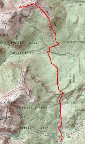
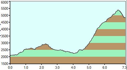
The weather was fine until we reached the top of Madison and a rain storm came in over us. After coming down from the summit, we were thoroughly drenched arriving at Madison Hut.
The weather was fine until we reached the top of Madison and a rain storm came in over us. After coming down from the summit, we were thoroughly drenched arriving at Madison Hut.