Training Log Archive: marieIn the 7 days ending Jun 12, 2010:
| ||||||||||||||||||||||||||||||||||||||||||||||||||||||||||||||||||||||||||||||||||||||||||||||||||||||||||||||||||||||
| « | » |
| » now | ||||||||||||||||
| Su | Mo | Tu | We | Th | Fr | Sa | |||||||||||||
Saturday Jun 12, 2010 #
run 5:00 [1]
warm up together with Mike
orienteering 23:02 [4] *** 2.4 km (9:36 / km) +100m 7:57 / km
spiked:9/11c
Perfect conditions, probably my favorite: wet woods, lots of oxygen in the air. Fun and tricky course set by Charlie. In most places you had to be right by the control to see it. Got stuck in the mountain laurel a few times. Exited 9 in the wrong direction, attacked 10 from the hill which probably wasn't the best option.
FR 3.171 km
FR 3.171 km
orienteering 13:07 [4] *** 1.7 km (7:43 / km) +80m 6:15 / km
spiked:10/12c
The second sprint, also very fun and with less mountain laurel. Went in a bit early to 1, exited 10 in the wrong direction.
FR 2.073 km
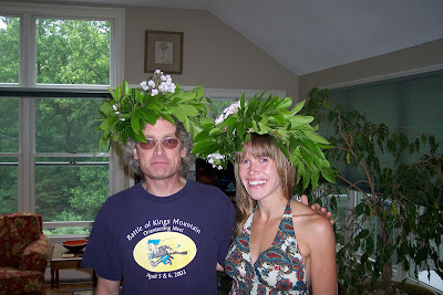
Got crowned as the Laurel Queen, together with the Laurel King JJ
Charlie's picture
Another wonderful event hosted by Charlie & Rhonda. Delicious food. Great to see everyone. Timoti, who came with us, really enjoyed it.
FR 2.073 km
Got crowned as the Laurel Queen, together with the Laurel King JJ
Charlie's picture
Another wonderful event hosted by Charlie & Rhonda. Delicious food. Great to see everyone. Timoti, who came with us, really enjoyed it.
Note
wow, Mike won the leg and beat me with 32s from 8 to 9 on Sprint 1! Better watch out! I did have some trouble getting out of 8, ended up using the upper trail, then just some hesitation entering the woods by 9.
Friday Jun 11, 2010 #
trail run 1:04:35 [2] 11.26 km (5:44 / km) +73m 5:33 / km
At West Rock with Mattias who's back from his hip-injury. Fun!
C • Cool 1
Thursday Jun 10, 2010 #
bike 10:00 [1]
bike to & from the gym
oo tough to get out of bed this morning while we stayed out late last night..
vroom vroom vespa tour
so happy that Vic Ruggiero joined the show =)
oo tough to get out of bed this morning while we stayed out late last night..
vroom vroom vespa tour
so happy that Vic Ruggiero joined the show =)
pilates 50:00 [2]
walk (hike) 54:40 [1] 3.74 km (14:37 / km) +136m 12:22 / km
Mike & I went to Sleeping Giant. Haven't been there in a while. Maybe not the best time to go hiking right after a downpour. Roots & rocks were a little slippery. We went up the head (where you pretty much use all four), down to the big trail, parking lot and a lap around the nice pine tree area.
Tuesday Jun 8, 2010 #
bike 10:00 [1]
to & from the gym
pilates 50:00 [2]
My pilates teacher is great! She's been having this IT-band problem for a while, yesterday she got a cortizone shot and so now she's not allowed to exercise for a week.. but she still came in and gave class, sitting, just giving verbal instructions.
Monday Jun 7, 2010 #
bike 10:00 [1]
to & from the gym
zumba 1:00:00 [3]
Wow, starting to get too crowded for class to be enjoyable. Would work if the girls would have a better sense of staying in their lines, now after a few songs it's just a mess..
Sunday Jun 6, 2010 #
Event: Gay City State Park
run 5:00 [1]
warm up
orienteering 1:06:15 [3] *** 7.21 km (9:11 / km) +107m 8:33 / km
spiked:7/14c
It is a very nice drive from Old Saybrook to this park. Today I saw a turtle crossing the road at one place, we turned around, stopped and carried it across.
Warm and humid, was getting a bit windier due to the storm building up. We're spoiled with always having SI running WCOC events, today was old school punches, kept my card in the map case so at every control: fold up/fold together, sigh. At the start with about 30s to go I got to answer an unknown man about our planned move to Sweden(?)
1 Ran down towards the bridge, didn't expect it to be so steep. Trail uphill. Cut off, crossed the other trail, rounded the hill to the right. Crossed marsh but still wasn't close enough to see the big cliff. Up the hill and read on some of the boulders. Thought I would see the spur before the control but I didn't, took a lap around the area before I saw the control further down.
2 Compass. Ended up slightly left down by the reentrant, turned around and ran up.
3 Way off to the right. Got it to correspond to the map as I finally got to the trail (which was the wrong one, the yellow), crossed it, read on some boulder and green. Was looking for the control up there for a while. Remember thinking that it wasn't very well mapped (no wonder!). Figured it out, ran downhill, crossed an awful swamp, got on the right trail, went into the woods when I saw the boulder.
4 Pretty much straight on
5 To the right of the line, crossed the trail & the stone wall. Went too much left to the boulders in the green. Corrected. Saw an unhappy George, even though I thought he was running Red and that he had caught me..
6 To the left of the line, went uphill on the trail, compass
7 Compass + reading contours and some features. Glad I was told about the unmapped mtb-trails in this area.
8 Downhill, hit the trail, cut off where the line crosses the trail, through the marsh
9 Compass + reading the stonewalls
10 To the left of the line
11 Compass, crossed the trail, tired, crossed the stonewall, went too much right, crossed that stonewall and then stood still for a while figuring out where I was
12 Followed the stonewall north, took way too long time trying to find that little trail when I saw the road(!) finally just cut through, crossed the road, cut through to the trail, read on the contours
13 Cut through to the trail, ran on it for a while, went off left, downhill, crossed the green marsh (didn't plan to), trail for a bit, ran along the hill
Oh man! Just found an obvious trail from 12-13 looking at PG's gps-route.
14 Cut through to the trail. Jumped out of some bushes onto the trail and scared a family out hiking.
FR 8.758km
Had an annoying stomach cramp for the whole run and a weird tense/pain in my right shoulder. Still felt good being out there, there are areas with really nice terrain & it was a fun course.
I was wondering what the brown triangles on the map were symbolizing, I got it explained to me that they are charcoal platforms. I am used to them mapped as black rings.
Hung out for a while afterwards and heard some great stories about encountering beavers in this park and about running around with blue beer cups on the head :-)
trail run 10:00 [1]
Jog around some trails, went by the massive boulder close to the parking lot - cool!
On our way back we stopped to check out Devil's Hopyard SP, it looks beautiful! Did a mini hike up to the waterfall. Will definitely go back here soon to check out the trails.
On our way back we stopped to check out Devil's Hopyard SP, it looks beautiful! Did a mini hike up to the waterfall. Will definitely go back here soon to check out the trails.