Training Log Archive: PGIn the 7 days ending Dec 3, 2011:
| |||||||||||||||||||||||||||||||||||||||||||||||||||||||||||||||||||||||||||||||||||||||||||||||||||||||||
| « | » |
| » now | ||||||||||
| Su | Mo | Tu | We | Th | Fr | Sa | |||||||
Saturday Dec 3, 2011 #
orienteering 28:40 2.24 mi (12:48 / mi) +377ft 11:02 / mi
ahr:156 max:164 shoes: x-talon 212 #2
Really nice job by Phil, plus some help from the NEOC bosses with registration and the e-punch operation, all went very smoothly. I particularly like how Phil placed the controls. Always seemed to be just the right amount of visibility.
Crisp, clear day. Perfect. Lots of good orienteers on hand.
The course.
.jpg)
orienteering 20:41 1.54 mi (13:26 / mi) +217ft 11:51 / mi
ahr:158 max:168 shoes: x-talon 212 #2
.jpg)
orienteering 27:16 2.39 mi (11:25 / mi) +233ft 10:27 / mi
ahr:164 max:171 shoes: x-talon 212 #2
The course.
.jpg)
orienteering 35:05 1.36 mi (25:48 / mi) +184ft 22:52 / mi
ahr:124 max:142 shoes: x-talon 212 #2
Friday Dec 2, 2011 #
mapping 1:07:47 [1] 1.1 mi (1:01:50 / mi) +174ft 53:46 / mi
Most of what I did today won't be used because the woods suck, lots of thorns. So lots gets mapped at dark green and just left at that. If there's a boulder in there someplace, I'm not going looking for it.
Started and finished at Dave's house. Saw him afterwards, he knows the Earl who made the bike trails and after whom the area is named, and some point in the next couple of weeks he'll take me to meet him and hopefully learn some of the history.
Now to give all my scribbling to JJ and see if he can make some sense of it.
Note -- forgot to start the 305 until I'd been out 5 or 10 minutes.
Thursday Dec 1, 2011 #
mapping 57:45 [1] 1.36 mi (42:36 / mi) +200ft 37:22 / mi
Just one more corner to do. And then turn it all over to JJ to do his magic.
And then figure out what to do with it.... :-)
Wednesday Nov 30, 2011 #
road running 28:01 [3] 3.17 mi (8:50 / mi) +394ft 7:55 / mi
On the other hand, I think there have been many times in the past after a training break when the first X (where X could easily be 10 or 20 or more) runs felt like shit, but then things eventually felt a lot better. So it makes sense to feel like shit now. Just hope the reward is out there at some point too.
Tuesday Nov 29, 2011 #
Note
treadmill 25:46 [3] 3.0 mi (8:35 / mi)
shoes: pegasus #2
Still not completely well, head cold is mostly gone, but the sore throat just lingers. Stopped by the doc's this morning just to see if anything more serious was going on. He didn't think so.
Monday Nov 28, 2011 #
Note
During 61 hours of mapping, number of ticks seen -- 0. :-)
road running 21:33 [3] 2.55 mi (8:27 / mi) +85ft 8:11 / mi
weight:140.5lbs shoes: pegasus #2
Did it unaccompanied. Not sure if that was foolish or not, but what the hell, got to take some risks.
Sunday Nov 27, 2011 #
mapping 3:41:41 [1] 3.71 mi (59:45 / mi) +751ft 50:08 / mi
mapping 1:48:23 [1] 2.44 mi (44:25 / mi) +197ft 41:16 / mi
Ran into an older couple out walking. What was I doing? Making an orienteering map. Oh, great, we need a good map.
And then as I was leaving they ambled out to where I was parked. Showed them what I was doing. The guy wanted to know how they could get a copy. So I got his e-mail address. And in the course of the conversation, he said if I needed any help with town officials at any time, just get in touch with him, he knew them all and would be glad to help.
Put a smile on my face as I drove off.
Still to do (northeast) --
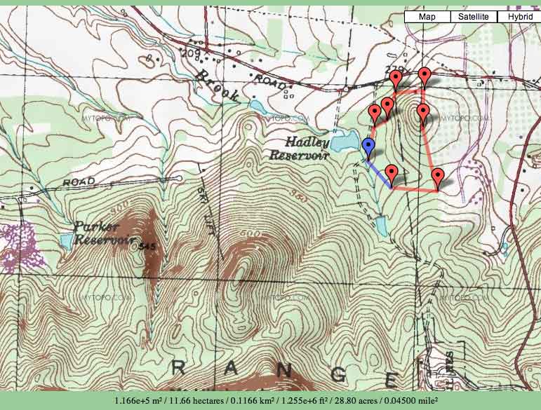
Still to do (northwest) --

And done so far --
