Training Log Archive: JanetTIn the 7 days ending Aug 10, 2021:
| |||||||||||||||||||||||||||||||||||||||||||||||||||||||||||||||||||||||||||||||
| « | » |
| » now | ||||||||||
| We | Th | Fr | Sa | Su | Mo | Tu | |||||||
Tuesday Aug 10, 2021 #
Note
Monday Aug 9, 2021 #
Note
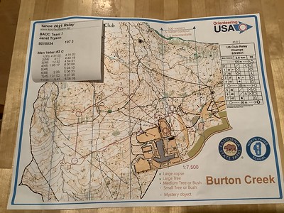
Orienteering race (Club Relay) 53:29 *** 3.42 km (15:38 / km) +28m 15:01 / km
ahr:117 max:138 spiked:5/7c (injured) shoes: 2019 VJ Falcon 6.5 scot
Club Relay at Burton Creek near Lake Tahoe, starting from the fields behind the high school. Mid 80s by the time I went out a bit after 1:00. I had the 2.6 km C course (the other men's veteran team courses due to forkings were 2.5 and 2.7); 35m climb on all three; 1:7500 map.
Start was delayed from 10AM to shortly before noon due to ... who knows? Short staff? Someone taking on too much work? The results crew in charge of printing the maps?? I'm not sure this bodes well for NAOC in two years with this crew unless they solve the glitches. At least the volunteers were cheerful.
We also had to move our cars from the HS parking lot because "they were going to re-stripe it today" after it had been recently repaved (but they didn't so it while we were there); Glen moved it down the road a bit and we got a lift on the way back by someone headed that way who had a lot of room in his vehicle.
I was leg 3 on a DVOA men's veteran's (MV) team because it really didn't matter; and in fact my leg 1 and 2 runners had to leave for the airport and never downloaded (because download wasn't ready until just before I finished, and a bit after 2PM...). We likely weren't going to be earning many points for DVOA, with better runners registered (DVOA had four teams, and top 5 in their categories earned points).
Rob Wilkison ran first, but had trouble with number 1 and took just under an hour; Jim Eagleton ran second and finished the spectator loop quicker than I expected, such that he passed the finish punch before I got to the tagging area (but I *was* on my way there, so just picked up my map and started).
Because Jim was catching a plane in Reno and Rob was taking him there, they were gone before I finished and before download was ready to go. So we'll be listed as DSQ.
I had a bit of trouble on #1 (~2:30) and #5 (~5:00), both times being off to the left but stopping at about the right distance and relocating. I saw control 31 (not mine, but on a boulder) near the ride junctions and thought I identified it correctly on the map, but then got off line to my boulder cluster, and corrected when the land was starting to drop off some (there was a reentrant/dry stream beyond it) and then stumbled into it.
To #2 I wanted to go straight north but the downed logs kept pushing me to the left into clearer woods (it was too slow for me to have to swing my bad leg over them all and chance falling), but I had no trouble once I reached the road. To #3 I should have swung wide right back to the road and attacked from the group of large boulders to the SE, which--while more distance--would have saved me from drifting offline until I realized the broad spur was sloping the wrong way since I was too far north. Along the beeline, in what was mapped as rough open and white woods, in reality there were dozens and dozens of dead log "haystacks" reducing visibility. I missed it by just a few meters while relocating to the road and coming back to it from the large boulders to the SE.
The spectator control (#4 and 7) was just outside the field where we were assembled, and we were to run diagonally across it and do a few more close-in controls before returning to that control and finishing. There were still teams finishing after me, but I couldn't download right away because the first leg runners were lined up and went first.... and the splits printout was wonky with no total time and a missing split. Anyone surprised?
Fun to chat with other orienteers and catch up with their goings-on as we cheered on our teams. And it was nice to be able to go orienteering again despite my physical challenges of the moment.
Sunday Aug 8, 2021 #
Note
And I think I saw a female western bluebird on the walk back to parking after today's race, checking for insects only a few feet away in the woods. I might have seen a similar bird while on my course yesterday.
Walking 34:09 2.42 km (14:05 / km) +60m 12:32 / km
ahr:105 max:123 shoes: 2019 VJ Falcon 6.5 scot
We worked the first hour and a half shift at Start again. The start lanes were set up in the woods along uneven areas, some more so than others. We groomed the lanes as much as possible, moving sticks and large pine cones that could trip someone (like me) out of the way, and also made the executive decision to move the clear box closer to where competitors first entered the T-8 warmup area (I worked at the T-4 minutes call up line and checked off names of the Men coming through my line; the clear boxes had been at T-4 yesterday).
The time went quickly, mostly, except during the odd minutes when no one was called up.
Orienteering race (Long Champs) 1:24:54 *** 4.93 km (17:14 / km) +149m 14:58 / km
ahr:120 max:166 spiked:8/8c (injured) shoes: 2019 VJ Falcon 6.5 scot
Mostly clean inside the circles; I did hook around some other thickets on the way into my first control, partly due to rocky ground...I was trying to find a way up the little hill it was in without falling. Also hooked into #6 and took a slightly circuitous route on the way from 5-6...could have been relatively faster if I'd found the ride that led to the start triangle; instead I worked my way down to the road junction and took the road toward the triangle and angled off just past the green blob S of the line.
Otherwise I has very happy with the execution of the legs if not my speed in the fairly open terrain, where I had to slow down to safely swing my right leg over logs and other tripping hazards. As it was there were either some wires or strong vines near ground level that almost tripped me a few times...glad I had my pole! The almost-1km leg from 1-2 scared me at first until I decided to ignore the multiple indistinct rides I couldn't really see in the terrain, and just use the contours until I got close enough to figure out the clearings near the control.
To #3 I saw a boulder near a trail and knew I hadn't gone far enough and that it wasn't mine but went back a few steps to check the number (109) anyway. Saw Dave Tallent there (who was on the other "Brown" course) and a young girl who asked if I was looking for 118 or 108. I replied no because my next control was 156. I'd just been to 118, though.... He ended up taking over 3 hours on his course. Attacked #3 from near the trail/"stream" jct and from a good distance away saw Ed Gookin and his red O suit at the control. Thanks, Ed!
To #4 (close to 600m, uphill) I went through a lovely open field (the only one I see on the map) with low vegetation. A woman on my course (and in my class) was traversing it in the opposite direction, which I thought an odd and very out of-the-way route choice if she was headed to #2. When I hit the trail before the climb to the control I tried to identify the "green blob in a clearing"near the trail, but didn't find it; still I was fairly sure I was close to it so headed uphill looking for the semi-open area with boulders at the edge to attack from, and came upon the one SSW of the flag...score.
In 2nd place when I finished but unsure about Janet P's time (she worked at the start 2nd shift and ran after); she finally came in and I could see she took 2+ hours. So 2nd it is. :-) A young fellow with a bag of medals from the Sprint and Middle found Glen and me and gave us ours (Glen got a Gold in Sprint and I got bronze/Sprint and silver/Middle) and also the ones to give to Peggy & Nadim who we could see across the road. I knew coming into this weekend that Debbie would most likely get gold every day and it would be between Janet P and me who took the next two places, so I'm happy with my placing on the more technical days, given my self-inflicted physical limitations.
Map for course 3: F-Brown, all F 65+ and M 75+
Walking 32:04 1.94 km (16:32 / km)
ahr:109 max:153 shoes: 2019 VJ Falcon 6.5 scot
Cars passing by and kicking up dust didn't help the breathing any. ;-)
Saturday Aug 7, 2021 #
Note
Hiking (to start) 33:34 2.39 km (14:01 / km) +25m 13:19 / km
ahr:104 max:140 (injured) shoes: 2019 VJ Falcon 6.5 scot
We signed up to work at the start today and tomorrow, so got there before most of the competitors, and learned our assigned tasks. I got to check that all the non-elite men showed up for their start times, and check them off the list. It was advertised as a "silent start" i.e. no talking, but I ignored that and quietly reminded people to clear and check, and when to move ahead. They could have used a complete set of clear/check boxes at each start lane (of four). And they could have used all the minutes to start people, instead of just the even ones. Lots of wasted time standing around, but we didn't get backed up.
This was a practice run for the NAOC here in 2023.... some lessons learned? Maybe.
I'm keeping the "injured" label until I actually feel okay jogging again, not that I do much to begin with.
Orienteering race (Middle Champs) 41:28 *** 2.49 km (16:38 / km) +53m 15:02 / km
ahr:128 max:146 spiked:10/10c shoes: 2019 VJ Falcon 6.5 scot
After my shift at start, I changed my shirt, and got the rest of my stuff ready, then waited until my start time was displayed on the clock. I knew what to do at the first "call-up" line because that's where I had worked; and I'd experienced the other stages at the Sprint start yesterday. Today we were to punch a start box, but I didn't recall details from the meet notes (they were located near the start line) and I don't recall being "told" to punch it, but saw others doing so so I did. Then off down the streamered path to the triangle. I had a hiking pole with me (I'd packed it and planned to use it if we did some more strenuous hikes, but them smashed my knee; it was very useful to help maintain my balance).
First 4 controls were downhill from start, then some climbing was required. The first leg, if you went straight, took you almost through the Go control. As I descended the hill and crossed two roads I noted the activity below but it took me a few seconds to realize what was going on. I passed close to the Go control as Rob Wilkison was headed to the finish chute.
Good to #1, finding the large boulder near the ride before the control.
On way to #2, I needed to go about 300m in the right direction. It was hard to differentiate what trees might have been mapped as distinct so I mostly ignored the, but then I saw Peggy floating by and headed generally in the direction she went. She was long gone as I approached the bag, but it helped a bit to see where she was headed. #3 and #4 were short fun legs that I would have enjoyed more if I could actually jog, but so be it. Then a climb to #5.
I was a bit unsure what rocks I was crossing on the way to 5 (there were more visible than met mapping specs), but a couple other people, including Nadim, were headed to it too, and I spotted the flag.
I should have gone all the way up to the road to #6, visible from the road (and apparently a spectator control as it was near download), but I stayed in the woods and likely lost some time (relatively).
A few more short legs through detailed rock, and then across an open area before the Go control.
Their split analysis indicates "errors" at 5 (uphill), 6 (where I should have climbed to the road), and 9, where I snaked around the mid-way rock pile rather than going through, or around the other way, but I didn't deviate enough to call any non-spikes. I forgot to always hit my watch as I passed controls; I think the SI Air card (where you don't need to stop) messes up my flow/routine.
I'm either 2nd or 3rd (again). Debbie Newell is in good shape and did the course in about 36 minutes today.
Map for course 4: F-18, F55-69, and M65-79
Hiking 52:26 2.66 km (19:43 / km) +40m 18:20 / km
ahr:104 max:134 shoes: 2019 VJ Falcon 6.5 scot
Friday Aug 6, 2021 #
Note
Orienteering race (Sprint Champs) 19:54 *** 1.84 km (10:49 / km) +4m 10:42 / km
ahr:113 max:191 spiked:13/13c (injured) shoes: 2019 Altra LP4.0 9 rspb
A fairly straightforward map and course, with a couple left-right route choices, and a few inside/outside corner placements to pay attention to.
Attackpoint labeled this "walking" (which is what I did, except for a little skip-jog near the end on the downhill ramps)...power-walking as much as I could once I'd made route choices. My knee wasn't going to tolerate jogging, and is aching a bit now, later in the evening.
Don't believe the heart rate spike at the end...finish was uphill but not *that* strenuous. I did wear a chest strap for this course.
Map for course 4: F55 and up, M65 and up, F- and M-Brown
Orienteering (map hike) 44:30 1.71 km (26:04 / km) +57m 22:20 / km
ahr:104 max:139 shoes: 2019 Altra LP4.0 9 rspb
Visited 5 of the 8 controls, partly so I could visualize what's mapped as what and partly to see how slow the going will be for me.
We'd picked up model maps at packet pickup last night, which was good because while all papers had three scales of map (1:7500, 1:10000, and 1:15000), the papers in a box at the model didn't have circles on the 1:7500-scale version of the map, and the coloration on just that one was different.
Thursday Aug 5, 2021 #
Note
(rest day)
It had been getting smokier throughout the afternoon yesterday, and by this morning was cool but a bit smokier. Small bits of white ash were all over the car. We headed south from KlamathFalls and drove through Tule Lake NWR on the auto tour looking for wildlife, mostly birds. The northern lake closest to the visitor's center (closed) had absolutely no water in it; the other one had some. Probably few birds we hadn't seen before elsewhere, though white pelicans in the summer are pretty rare where we live. I might have seen a Clark's grebe in passing but didn't get a photo. :-(
Then it was time to head south to get to and through Susanville, which is located northeast of the growing Dixie fire, and roads were closed a few miles west on Rt 36. At some point we donned our masks *inside* the car because the air (already on recycle/inside air) smelled smoky. It was other-worldly looking when we arrived in Susanville and got sandwiches for late lunch...red dirt and red sky...could have been Mars except for the vegetation. As we drove away with the dark sky in the rearview mirror we breathed easier, and eventually hit clear blue sky and no more smoky smell.
Wednesday Aug 4, 2021 #
Note
Hiking 2:12:06 5.72 km (23:05 / km) +342m 17:46 / km
ahr:83 max:142 (injured) shoes: 2019 Altra LP4.0 9 rspb
Along the way were two tall waterfalls (Lower South Falls at 93' and South Falls at 177') with undercut cliffs, which really messed with the GPS signal, so don't take the climb number too seriously (the distance is probably off by a bit as well). ;-) The brochure claims the hike is 2.6 miles and the climb is 400'.
The falls were ribbon-like and very straight, dropping to large pools. The paths behind the falls were neat, and the rock layers looked pretty solid, except in one place behind South Falls where there was a vein of soft rock, rather chalk-like.
A few neat looking flowers (tiny purple flowers on a nettle and some other unidentified plant), plus salal and ocean spray shrubs, and Oregon grape holly. Several trees looked popular for kids to climb on including western red cedar. The forest smelled wonderful.
I took a hiking pole, and had some trouble with some of the staircases and went slowly on the steeper downhill slopes so as not to slip/fall, but managed well. Keeping my knee straight-ish still puts a crimp in my stride so I'm going to keep the "injured" tag until I feel less restricted. I'm down to just a large bandage covering the knee area, and painkillers when it gets achy due to bruising under the kneecap, but the cuts/stitches themselves are healing fine and I never started the antibiotic prescription I had filled just in case.
We also drove down to the parking area for NorthFalls which has an even deeper overhang behind the falls, but it was after 1pm and we wanted to get headed toward Klamath Falls where we're spending the night.
Once we got into the mountains the smoke layers picked up and we drove through the haze the rest of the way. Apparently the Dixie Fire west of Susanville (that we're passing thru tomorrow) is growing and the smoke is being blown north into those mountains.