Training Log Archive: JanetTIn the 7 days ending Aug 3, 2021:
| |||||||||||||||||||||||||||||||||||||||||||||||||||||||||||||||||||||||||||||||
| « | » |
| » now | ||||||||||
| We | Th | Fr | Sa | Su | Mo | Tu | |||||||
Tuesday Aug 3, 2021 #
2 PM
Hiking 34:49 1.13 km (30:57 / km) +24m 28:00 / km
ahr:86 max:116 (injured) shoes: 2019 Altra LP4.0 9 rspb
Short walk to a cute waterfall (Umbrella Falls) on the side of Mt Hood. I took my hiking pole. Upper 80s but not too humid. Lots of yarrow, goldenrod, fireweed, and some type of aster I think, in the meadows near the ski area and waterfall.
After our hike we drove to another waterfall lower sown, but also on the East Fork Hood River.
Once we got within about 25 or so miles of the mountain we could see it, but farther away it was too hazy.
We could see Mt Jefferson off to the west from Madras; it has the same general shape as Hood, and also with snow on the top. On the drive up we stopped at an overlook of the Crooked River gorge that has three bridges crossing it: a 1880s railroad bridge, the old two-lane highway bridge built in 1926 now closed to traffic but open for pedestrians, and the newer four-lane highway bridge, opened in the 1990s. All have the same general shape/appearance.
I've stopped using the ace bandage, and the swelling has gone down somewhat so my knee isn't as sore. I can bend it a bit more too but am trying to keep it as straight as possible; hard to do in the car. I'm encouraged that with sufficient warm-up I'll be able to orienteer next weekend, though likely not as fast as my typical slow pace.
7 PM
Note
Strolled around the grounds of the OR state capitol in Salem. Interesting specimens of redwoods and sequoias, and a few trees we couldn't find identifying labels for.
I now have fairly recent selfies or other photos of myself in front of 20 state capitols. (I've visited a few others and probably have photos but they're from back in the day and I haven't looked through photo albums since I started "collecting" the selfies a few years ago. I know we've been to the capitols in Santa Fe, Denver, and Salt Lake City). We have the opportunity to visit Carson City, as well, next week on the way back to Reno on our way home.
I now have fairly recent selfies or other photos of myself in front of 20 state capitols. (I've visited a few others and probably have photos but they're from back in the day and I haven't looked through photo albums since I started "collecting" the selfies a few years ago. I know we've been to the capitols in Santa Fe, Denver, and Salt Lake City). We have the opportunity to visit Carson City, as well, next week on the way back to Reno on our way home.
Monday Aug 2, 2021 #
9 AM
Orienteering 1:34:04 *** 4.67 km (20:08 / km) +85m 18:27 / km
ahr:106 max:162 spiked:5/7c (injured) shoes: 2019 VJ Falcon 6.5 scot
No HRM again, so readings might be funky.
Two-hour score-O on a new map near Peterson Ridge south of Sisters, OR. 1:10000/5m. Temp about 76 when we arrived. It got a bit warmer while I was out, then clouded up, thundered, and showered for a bit after I was back, changed, and waiting for Glen to change too. Cooled down a little bit not much.
Rather than sitting home again, I decided to go out, see how slow I needed to go, and be very careful where my right foot went so it didn't catch on anything. I also took and used a hiking pole to help maintain my balance.
My first thought was to head east out the road and get a high point control and pick up a few others on the way back, but it took three minutes to go the 150+ m from start to the road, and then I noted the road heading downhill, meaning an uphill slog at the end, so I changed my mind and headed the opposite way. Slow and steady to the first control, off a trail off the road. Careful climbing over the downfall on the trail, and getting to the flag, then getting back to the trail.
I misread the map next and went wandering up the hill in crappy vegetation and manzanita before realizing the little rocks I saw were *not* the mapped double boulders I wanted to use as an attackpoint. Back down the hill, then up through the nice white woods to a bigger boulder. The rest of the 7 controls I visited went well, and I even bushwhacked from #61-58 because the woods looked fine, rather than going down to a trail and having to climb back up. By the time I left #58 to head back towards finish I was feeling tired and ready to finish.
My knee bothered me for the first 1/2 hour or so but then endorphins kicked in and I was moving a little bit faster, though nowhere near how fast I want to go.
Finally have a chance to put it up and ice it, after we stopped in Sisters for lunch, in Bend to do laundry, stop at a store, and have dinner.
Sequence: 51-55-53-56-61-58-66
30+40+30+40+50+40+60=290 points
Sunday Aug 1, 2021 #
Note
(injured) (rest day)
FWIW, I wore a HR strap yesterday but not Friday. Unsure how different the sensing is between wrist and strap, but conditions Friday were hot and hilly, while yesterday was cooler and overcast, with much less climb on the course.
I always take the readings with skepticism anyway.
Keeping my knee iced and elevated today; hopefully it won't be too stiff and swollen in a few days, and maybe slightly bendable by next weekend?
I always take the readings with skepticism anyway.
Keeping my knee iced and elevated today; hopefully it won't be too stiff and swollen in a few days, and maybe slightly bendable by next weekend?
Saturday Jul 31, 2021 #
9 AM
Orienteering 1:46:04 *** 6.36 km (16:41 / km) +44m 16:08 / km
ahr:114 max:145 spiked:11/12c shoes: 2019 VJ Falcon 6.5 scot
Green course by Ali C, 5.5km, not much climb, at Arnold Ice Caves 20 minutes or so south of Bend. 1:10,000/3m scale. It was overcast today so the temp stayed in the mid 70s, I think. Some sprinkles occurred as were getting changed afterwards, and off and on the rest of the afternoon; hope it doesn't shower when we're supposed to have a barbecue tonight or it will be grab 'n' go and not a social event.
The terrain had as much sage as yesterday but more volcanic rock outcrops (the choppy/blocky rough kind), some cliffs, and a number of mapped distinct trees, some of which were useful. :-) The general color scheme was rough open, rough open w/scattered trees, some white blotches where the trees were closer together, and a few patches of vertical green lines to designate where there was deadfall. Much of the rough open had loose sandy type soil, so it felt physically like the effort to move through low blueberry bushes...tired legs later!
Started ahead of Glen (also doing Green) because he wanted more time to get warmed up. Pretty straight to 1 and 2, which were in detailed areas. #3 was about 600m across a relatively flat area, so good bearing following was called for. Rick Breseman passed me shortly after I crossed the road; I kept him in sight for a little while bit navigated into it on my own. #4 was described as a hill; I could see a very large rock in the direction I wanted and headed for it, but the description was hill, and it was a smaller mapped hill in front of the large rock, with other people headed for it too. There was an area of tight vertical green between 4 and 5, so I hooked a bit to the right of it and came in from the north. Glen arrived and punched after me and then took off. About halfway to 6 I could the large spur with cliffs I was headed towards, and eventually Glen turning away from it, confirming where I was headed.
#7 followed, another long leg (close to a km) with a distinctive rocky hill and spur about halfway so I made sure to go by there on my way. Debbie Newell passed on the 2-contour uphill a short time after leaving 6 and was moving considerably faster through the terrain than I, although still at a walk. Still, it was open enough that I had her in sight most of the way to 7, though she took a line a bit to the left of where I was headed. A couple more people passed in the last few hundred meters and there was a >90 degree right turn for the next leg so I could see about where people turned.
Okay through the water control, #9, but on the approach to 10 after the road crossing I misread the rockiness I saw as the hill pointing to the distinct tree; I think I was actually on a parallel line 70-80m S of where I should have been, and then nothing made sense. Headed back towards the road but then saw the bag from a distance.
South over a small spur and into more rockiness to another cliff at the edge of forest. The flag was tucked in an area surrounded with tall dried shrubs that I wanted to get out of so I stepped on a rock but it rolled under my foot and I went down hard on my right knee (I treat it SO poorly!) and scraped it up good. I didn't like the looks of it but the hole in my pants wasn't too big so once I got up (thanks, Kseniya's friend/husband? Choon!) I decided to finish the course...only one more control, between two boulders and then a trail to finish, though I could have saved a couple hundred meters skipping the last one and heading straight in.
After getting my shoes (filled with about 1/4-1/3 cup of sand each) and pants off, I washed my knee as much as I could and decided I wanted it looked at and a possible tetanus shot. Put two big bandaids on the area to contain the bleeding, and we stopped at an urgent care center on the way back to Bend, where the doctor* looking at it put three stitches each in two small cuts which run vertically on my knee. I'm to keep it relatively straight and ice/elevate it (because of bruising) for the next few days. Stitches don't come out until we're home.
No more orienteering for me here in the Bend area. I'm hoping to be able to get out on maps in CA (and I do have a hiking pole to take along for extra stability...), but it will likely be slow going.
*in talking about why we were in Bend, I mentioned orienteering, and she mentioned she'd gone to school with someone who'd been on the national team a while ago...Karen Williams!
Friday Jul 30, 2021 #
Event: Deschutes Daze 2021
9 AM
Orienteering 1:19:03 *** 5.43 km (14:33 / km) +134m 12:58 / km
ahr:137 max:174 spiked:8/10c shoes: 2019 VJ Falcon 6.5 scot
Brown course at Crooked River Nat'l Grassland near Madras, OR; 4.5km, 100m climb claimed. 1:10000/5m map. Broad hillsides and reentrants with rough open (plenty of sage and other undergrowth) and woods; relatively trivial navigation; a lot of slogging.
Mostly sunny and upper 70s when we started, mid 80s when we finished, before noon, thankfully. It's getting even warmer this afternoon, but it wasn't too bad, considering.
Start was uphill from a road/trail junction where we actually received our maps. I'm happy the hill climb wasn't on the course.
I was a little off to the right going into #1, and a bit farther off to the right to #7, but otherwise followed my plans and found controls where I expected them.
The leg from #1-2 was an uphill slog through scattered vegetation most of the way, then a descent to a stream bed (no water) looking for a bunch of rock on the hillside including a 4m high boulder. I came upon three, no four, other orienteers first, all looking for the same control and wondering why they hadn't found it yet. Control #3 and a barbed wire fence were beyond #2 so we just kept going upstream until we finally saw a large chunk of rock. From there, #3 was a piece of cake.
To #4 I hope to hit the road near the bend, and did, going along it until the bend left/south before entering the woods and crossing the rocky ground. I saw the water bottles for the water stop before spotting the bag.
#5-6 had an out-of bounds mining area to skirt; I considered going below it before noticing that even the road leading up to it was marked out of bounds too.
From 6-7 I went NW from the road bend but never saw the road/trail I expected, or the fence next to it (probably should have headed due west) I must have been a bit farther to the right than planned, and I didn't correct until I got to the open/scattered trees and figured the road was uphill from me, so I corrected. #7 was visible from and just off a bend in the trail; in fact I'd say 5-7 of the 10 controls were yellow technical level....
By #8 Ali C had caught up to Sue K and me, and was in sight to 9, which was a bit tricky since there were several unmapped distinct trees in addition to the one near the control, but we just going to the more distant one until we saw Ali turn and head towards finish.
I think Sue K started ahead of me; I punched #2 and 3 just behind her, was ahead at 4 and 5, saw her in what I think was the oob mining area to 6, and the she caught up when I missed to 7. We punched 8 at virtually the same time. She was a bit faster after that (with Ali to key off).
Fun to see familiar faces at parking and finish. Steve and Betsy Tarry drove in around noon; Glen talked to Betsy (I sat in the car keeping out of the sun) and learned they'd had an extended traffic delay on the drive down from Portland.
Note
Walk to Event Center and Start, about 12 minutes. Walk back to car from finish (at Event Center), about 5 minutes.
4 PM
Walking 21:50 1.55 km (14:06 / km) +7m 13:46 / km
ahr:106 max:132 shoes: Saucony Ech7 8.5w-2
To Deschutes Brewery for dinner.
6 PM
Walking 34:00 1.75 km (19:26 / km)
ahr:91 max:133 shoes: Saucony Ech7 8.5w-2
And back to where we're staying.
Thursday Jul 29, 2021 #
Note
Today's activity was driving about 400mi from Reno to Bend. A few pits stops and a picnic stop in Modoc National Forest. Lots of wildflowers in bloom (sunflowers and buckwheat, among others) along the highways, surprisingly, but not much wildlife to look at until we got to Klamath Lake near the CA/OR border, where there were egrets and gulls and ducks, etc.
Got to try out a flight of Monkless Belgian Ales (they also had some food) for dinner. I'd noted their existence before but this was our first visit. Lots of tasty beers for me; a hoppier version for Glen to try but nothing really excited him. There are plenty other breweries in town, though.
To the grasslands near Madras tomorrow....
Wednesday Jul 28, 2021 #
Note
Travel day to NV en route to Deschutes Daze this weekend and Nationals in CA next weekend.
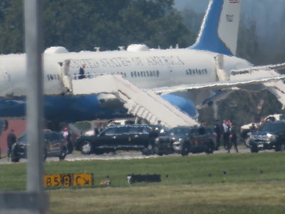
Entertainment at Allentown airport was watching Air Force One touch down and taxi to waiting moveable stairs. We even saw when the prez exited the plane. He was in the area visiting a Mack Truck plant.
At the ATL airport between flights we walked from terminal D to terminal A to get a bit of exercise. To bed early last night; up at 5am...