Training Log Archive: JanetTIn the 7 days ending May 3, 2014:
| |||||||||||||||||||||||||||||||||||||||||||||||||||||||||||||||||||||||||||||||||||||||||||||||||||||||||
| « | » |
| » now | |||||||||||
| Su | Mo | Tu | We | Th | Fr | Sa | ||||||||
Saturday May 3, 2014 #
Orienteering race (Brown) 1:22:28 [4] **** 6.24 km (13:13 / km) +250m 11:01 / km
shoes: Inov8 ORoc280-A 2013-08
63 degrees at start and mostly sunny so a gorgeous day to be in the woods. Only a few blackflies buzzing around, most annoying on the hill climb to 4 but otherwise not biting so barely noticeable.
My route:
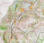 |
| From Track jpg files |
Through an administrative glitch I had the wrong control descriptions, so when I arrived at #1 on my map and found a charcoal platform #50 instead of a stone wall end #49, I was confused, as were Geof C. and Marilyn F. who had the same descriptions. Relocated off the E-W trail to the north and came back to the same place (as circled on the map), and figured out the control descriptions were bogus, and decided to continue on the course without them. (Got there in 13 minutes the first time but puttered around figuring things out, so 75 minutes would have been a good time for me.) No problem finding the controls as they were accurately hung, with the flag in the pit visible from a distance. :-) One dogleg, from 8-9 [perhaps an intentional Saeger-loop], but at least we didn't have to go on the steep/rocky west side of that hill like the Green course did.
On the way to 1, Geof picked up a stray brown lab who stayed with either him or me all the way through the course. No collar, but very well behaved and he obviously does this all the time (trail running, at least). Half the time he located the controls before I did (following previous runners' scents no doubt). :-) I lost him on the way to the finish as he crossed the road to visit the stream for a drink, but he picked up Geof and finished with him a few minutes later. Seems like the owners were parked in the next lot south of where we were.
Thanks, Lyn and George, for all your work, including last minute course design changes! The micro-sprint was fun and not too taxing.
Orienteering (micro-sprint A) 1:12 [5] ** 0.13 km (9:18 / km) +1m 8:57 / km
shoes: Inov8 ORoc280-A 2013-08
Slowed down by old (5-digit ID!) e-punch and changes of direction.
Orienteering (micro-sprint B) 1:05 [5] ** 0.12 km (9:06 / km) +1m 8:44 / km
shoes: Inov8 ORoc280-A 2013-08
Orienteering (micro-sprint C) 1:20 [5] ** 0.17 km (8:02 / km) +1m 7:48 / km
shoes: Inov8 ORoc280-A 2013-08
Orienteering (micro-sprint B) 1:01 [5] ** 0.14 km (7:32 / km) +1m 7:16 / km
shoes: Inov8 ORoc280-A 2013-08
Friday May 2, 2014 #
Note
slept:7.5 (rest day)
Worked on getting the Junior Team's bios posted. Meet the 2014 U.S. JWOC team!
Also, printed EMPO spring schedule brochures, and membership list for Sunday's meet.
Thursday May 1, 2014 #
Note
Pilates class 55:00 [2]
slept:7.0
Followed with adductors and pulldowns; plan to walk or jog (or both! if I find a decent dirt road) later.
Walk/Jog 40:52 2.65 mi (15:25 / mi) +76m 14:10 / mi
shoes: Sauc.Shad.6000#7-2012H
A contrast to yesterday's cold and rainy weather, this afternoon it was 72 and partly sunny - nice May Day.
Wednesday Apr 30, 2014 #
Exerc. Class 50:00 [1]
She has music pre recorded and manages to make the class almost the same length each time anyway, and we're all aware of her lateness tendencies. Mostly she's there "on time" and just starts the class a few minutes late. Good thing she has given certain people keys, who can arrive early and open the building for her (including steadfast 83-year-old Ruth).
Tuesday Apr 29, 2014 #
Note
Note
Pilates class 55:00 [2]
slept:7.0
Fitness equipment (elliptical) 27:00
shoes: Sauc.Shad-6000#8-2014H
Pulldowns and stretching after.
Sunday Apr 27, 2014 #
Note
Walk/Jog warm up/down (to start) 20:51 [3] 2.22 km (9:24 / km) +19m 9:00 / km
slept:7.0 shoes: Inov8 ORoc280-A 2013-08
:-)
Orienteering race (advanced) 1:26:09 [4] *** 6.28 km (13:44 / km) +47m 13:14 / km
spiked:8/11c shoes: Inov8 ORoc280-A 2013-08
Temp started in upper 40s with partly cloudy skies and a breeze, about 50 or so when I finished. Wore gloves on the jog to start (into the breeze that I had originally thought was blowing the other way) but I tucked them into my waistband as I waited to start.
8 good controls...that's why we do this, right? In the first part of the course (controls 1-7) in the Barrens area I mostly ignored the contours where there were only 1 contour hills because they were confusing. The open areas, marshes, and ponds were more distinct.
Navigated the first five perfectly, and even got ahead of a few folks on the 4th and 5th legs, but the flag at 5 wasn't on the east foot of the cliff as described! Looked around the cliff a bit, then checked out the next hill south until others came to the same cliff and found the flag tucked behind an unmapped boulder next to the cliff (I knew I should have looked there too). Grrrr! Lost a good 2 minutes.
Off to 6 which I did fine on, but then I tried to take a slight different route to 7 to not be part of the crowd, and I messed it up, ending up farther west and having to hook into it from beyond the point. Another 2-3 minutes.
Fine to 8, taking the shorter route around a marsh to the south (and crossing the outlet on a beaver dam) vs the north. Then headed out to the road rather than straight through the woods for 9, which was a good choice for me though it seemed to take forever to get to the trail which was a muddy morass anyway (ran alongside before deciding to cut the corner). Found 10 okay too, but then messed up the execution of 11, the last control. In a race situation I likely would have taken the safe trail route with a decent attackpoint, but I was attempting to stay closer to the line. I misidentified which marsh I skirted and wandered way longer than I should have when things didn't line up. My split vs Janet Findlay's was about 8 minutes longer, so a big mistake. I think I forgot by this point that the contours were only 2.5m. Still, time on this map is always useful.
No falls today, but I did poke my upper arm into a tree branch...that's gonna hurt.
With the nicer weather today it was much more pleasant to hang around afterward, though still on the cool side. I'm glad we came to this event. Thanks to OOC for organizing all the fun events (though we didn't take advantage of the other map training that was offered).