Training Log Archive: vmeyerIn the 12 days ending Jan 14, 2013:
| |||||||||||||||||||||||||||||||||||||||||||||||||||||||||||||||||||||||||||||||
| « | » |
| » now | |||||||||||||||||
| Th | Fr | Sa | Su | Mo | Tu | We | Th | Fr | Sa | Su | Mo | |||||||||
Monday Jan 14, 2013 #
Note
Rest day in Hastings.
Note
Tim and Phillip reduced the monitor stand by 2/3, and the monitors (TVs) went from six to two.
Later on, Jane and I went into Haverlock North to pick up my race packet and Callum, who had been off doing course setting for the day.
In the early evening, I set up a string course with controls for Callum to do punching practice on.

While my leg speed was slow, I have good punching technique, and I was pretty much staying ahead of the 10 second head start that Callum was spotting me.
Then, we switched it up, and I harassed Callum from behind, laughing all the way. Catherine joined us for several rounds as well. She also altered my USA top to give it a more flattering shape.
Sunday Jan 13, 2013 #
Orienteering race 49:24 [3] 2.27 mi (21:46 / mi) +119m 18:43 / mi
shoes: Another pair of new shoes!!


Finishing the Prologue: Will Critchley (Canada),

Carol Ross (Canada),

and Matt Scott (USA, currently living in New Zealand).

When it was clear that it was going to be such a hot day (around 80), and with the absence of any natural shade in the arena, Jane put a call out for club members to bring extra tents (gazebos), and bring them they did.

Terrain description: Mainly pasture with fences and farmtracks. Open gully and spur with areas of complex topography. Some steep faces.
Numerous small lakes. Some areas of plantation forest with good runnability.

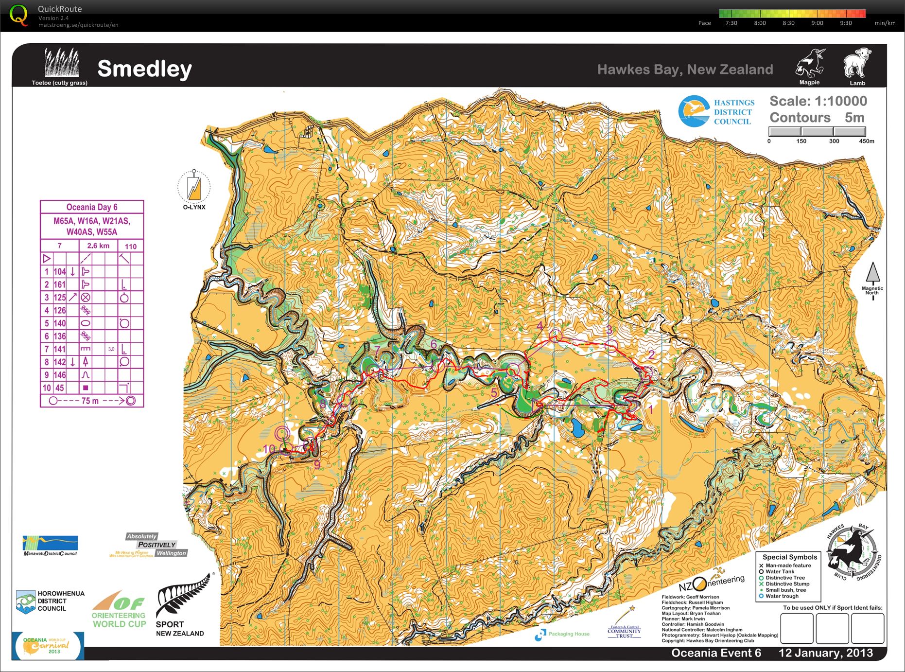
Mass start race. Tim and I were encouraged to make out mass start times, and so we concentrated on that, and Tim went out at 12:10, and I went out at 12:20. I was hurried, but I didn't feel rushed. Thankfully, I was reminded to take water, and I was grateful for that.
Had said all week that I wouldn't mind missing the mass start, since they make me nervous, and I was out of shape. However, I am so glad I joined the fun. Of course, finishing 9/26 in W55, and 43/86 on the course had a lot to do with it.
Pretty much ran my own race, staying in contact with the map the whole time. But, damn, it was hot! If the lake by #3 had been more inviting looking at the shore, I would have jumped it. I was so relieved to hit the woods for 6 and 7. That cooled me off some, but not enough, and not for long.
I really struggled from 8-9, especially on the road. When I got back onto the track, I considered sitting under a tree and phoning it in, but the quitter in me was missing, so I sucked it up and trudged on. I was clearer then lots of others to 10, and then found a good line to 11 where the fence was broken. After that I kicked it in to the Finish, even passing the guy who would finish one place behind me. Sometime earlier in the day, I declared that I would win a W55 Finish split either today, or during the six sprint events. Today I was 3rd with 36 seconds, 4 seconds behind the Finish split winner.
Was thrilled to find out that I had finished so well. I was sure that I was in my usual position of ~20th.

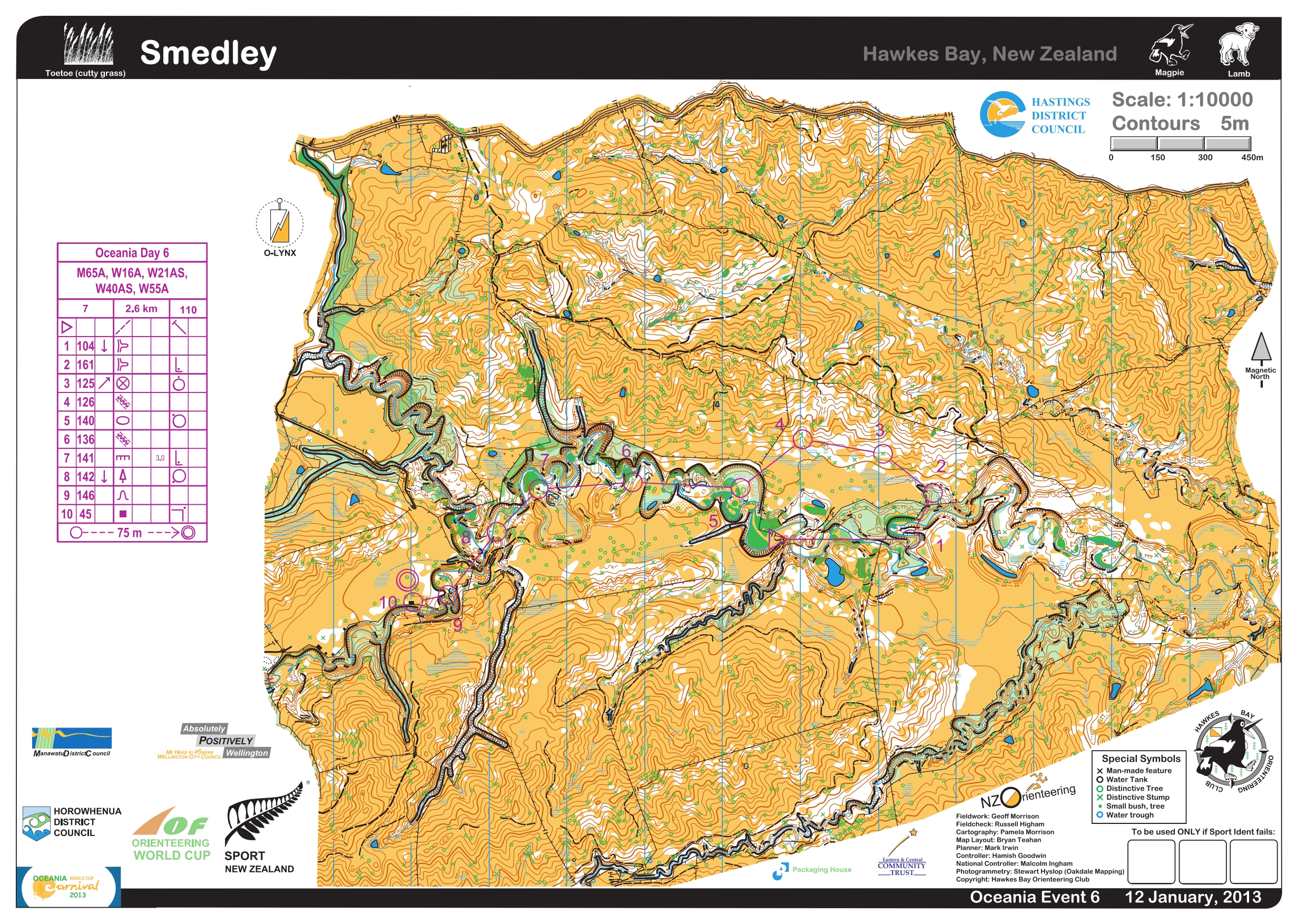
Race stats: 2.6 km, 145 m climb, 11 controls
Garmin distance: 2.27 miles with 119 m climb
Place: 9/26
Time: 49:25
Time lost: 1:56 minutes
Time per km: 19:14
Place on course: 43/86
Finish split: 3rd - 36 seconds, with 1st at 32 seconds.
The World Cup Chase started at 3 PM, and while it had clouded over for a bit, it was a scorcher.
Lots of people climbed to the hilltop across from the arena to watch the action.


A train of men.

Approaching the control from both sides of the fence.

Later on, I climbed back up the hill where the spectators were to retrieve two repeaters and to rescue J, a young man who had been winding up the tape used for marking the path up to the hilltop. The wind conditions were such that he had it wrapped all around him.
A couple of observations:
1) There was lots of poo (manure) at the event sites, since, well, this was either sheep and/or cattle country. I never quite got used to setting up next to cow pies. :)
2) I found it remarkable that there were no major course issues or injuries during the last 10 days. What an excellent way to end this portion of the trip!
After loading up, it was back to the Herries' place, where I was able to finally talk to Roger around 10 PM, just after Jane, Phillip, and I had finished a late tea.
Saturday Jan 12, 2013 #
Orienteering race 1:25:23 [3] 3.14 mi (27:12 / mi) +104m 24:39 / mi
shoes: Another pair of new shoes!!
Another day with temps near 80, and it was apparent that lots of thought had been given to the event center layout for the day, since the setup was done in a way that allowed the small bits of forest to be easily accessible for maximum shade cover for the participants.


Since I was going to take another late start, I indulged in a couple of sausage sandwiches for a mid-morning meal. I surprised then when I asked at 9 AM if the sausage were ready. They weren't, but I was set up soon after. These concession stands were interesting in that they were all parent run, with the profits going to their children's travel fund.

Linda Kohn, Rick Worner, and me - Team USA.

USA - Wild Country.

The Finish.

Callum, finishing strong.


Catherine worked in the download tent all day. Callum downloading.

Terrain description: Gully spur farmland with scattered totara, denser around some of the gullies and streambed surrounded by some impassable cliffs and native trees of variable runnability.
I loved this map and course! I just wish I had done it more justice. I totally butchered the first control, getting disoriented when I came through the light green. I made matters worse when I didn't recognize the fence junction where I was, and there was only the one in the whole area on the map.
As usual, I settled in a bit after that with only a little hiccup to 2, and the benefit of some elephant tracks from 2-3-4. I almost did something crazy from 4-5 when I ventured partway down the uncrossable cliff to see if it really was uncrossable. It was, and it was a bit scary getting myself back to safe ground. I kept telling myself that Jane and Phillip didn't deserve having to deal with me getting injured by doing something as stupid as trying to go down a cliff.
Used the creek as much as possible to finish up the course, especially after visiting the swamp near 7.
Race stats: 2.6 km, 110 m climb, 10 controls
Garmin distance: 3.14 miles with 104 m climb
Place: 19/27
Time: 1:25:18
Time lost: 10:45 minutes
Time per km: 32:43
Waited around for controls after everything was loaded up. Took the time to explore the HBOC caravan more closely - I want one!

And, the totara near the finish.

Friday Jan 11, 2013 #
O Training 1:20:00 [2] 4.0 mi (20:00 / mi) +50m 19:15 / mi
shoes: Another pair of new shoes!!

Terrain description: Generally rolling open farmland with isolated trees and good visibility, interspersed with hills, marsh, streams, gullies, scrub, native bush, pine forest, rock and taipos (rocky spires).
The repeater above 109.

The superfluous repeater between 109 (the control had been on the antler like wood pile) and the repeater above. One bar is all that is needed! Get over it!

The view towards the 87 hill.

Some sheep for Lailah. There were lots of sheep.


The repeater above 87. Retrieving this one later on was a little scary because the wind was blowing pretty hard.

The event center in the distance from the 87 hill.

Exited the hill from the back way.

After packing up, it was back up the highway to Hastings to stay for the duration.
Thursday Jan 10, 2013 #
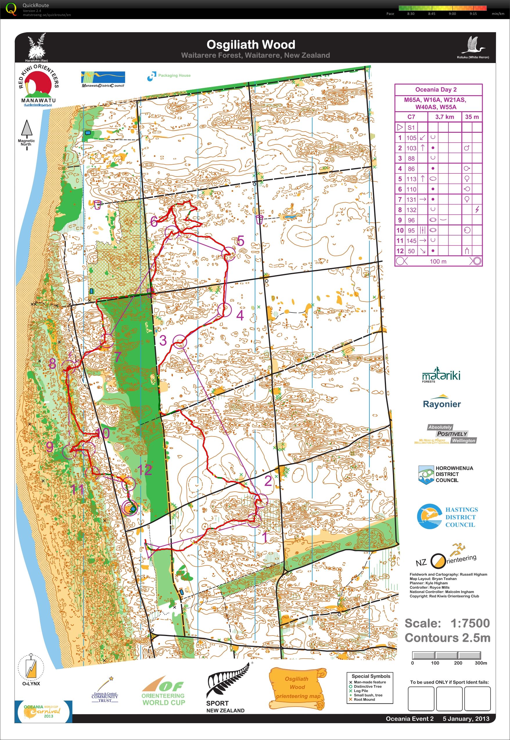
Orienteering race 1:58:34 [3] 4.73 mi (25:04 / mi) +275m 21:14 / mi
shoes: Another pair of new shoes!!
 (Courtesy of P. Herries.)
The wind from yesterday had died down, but the sun was pretty hot. The same routine as the other days - set up, hang out, go out on a course.
Terrain description: Generally fast open mature pine forest, with some patches of native Manuka trees. Several extremely step and gnarly gorges are crossing the area.
Today, I got a bit confused on what my start time was, missing it by 10 minutes, even after getting a ride from Jane to close to the start. Embarrassed myself by thinking I was just a minute late, even running up to the next line. Oops! It took them another two minutes to realize what had happened, and so I was pulled out, in the nicest possible way, and assigned the last start of the day.
Turned out to be a good mistake, because I got to chat with some other W55s, including Bronwyn for the first time. Just before Bronwyn's start, she discovered that the sole of her shoe was partway off. So, another woman offered up her wrist band, and I pulled off the headband, and we tied her shoe together and off she went. Headband to the rescue again!
Then it was my turn. This terrain felt familiar, so I was a bit ticked off at myself when I messed up the first control. Settled in after that, but took the really long way to #3 and a bit of an adventure in the scruffy part to #7. Had not had enough to eat that day, and I bonked and stumbled my way around to the finish.
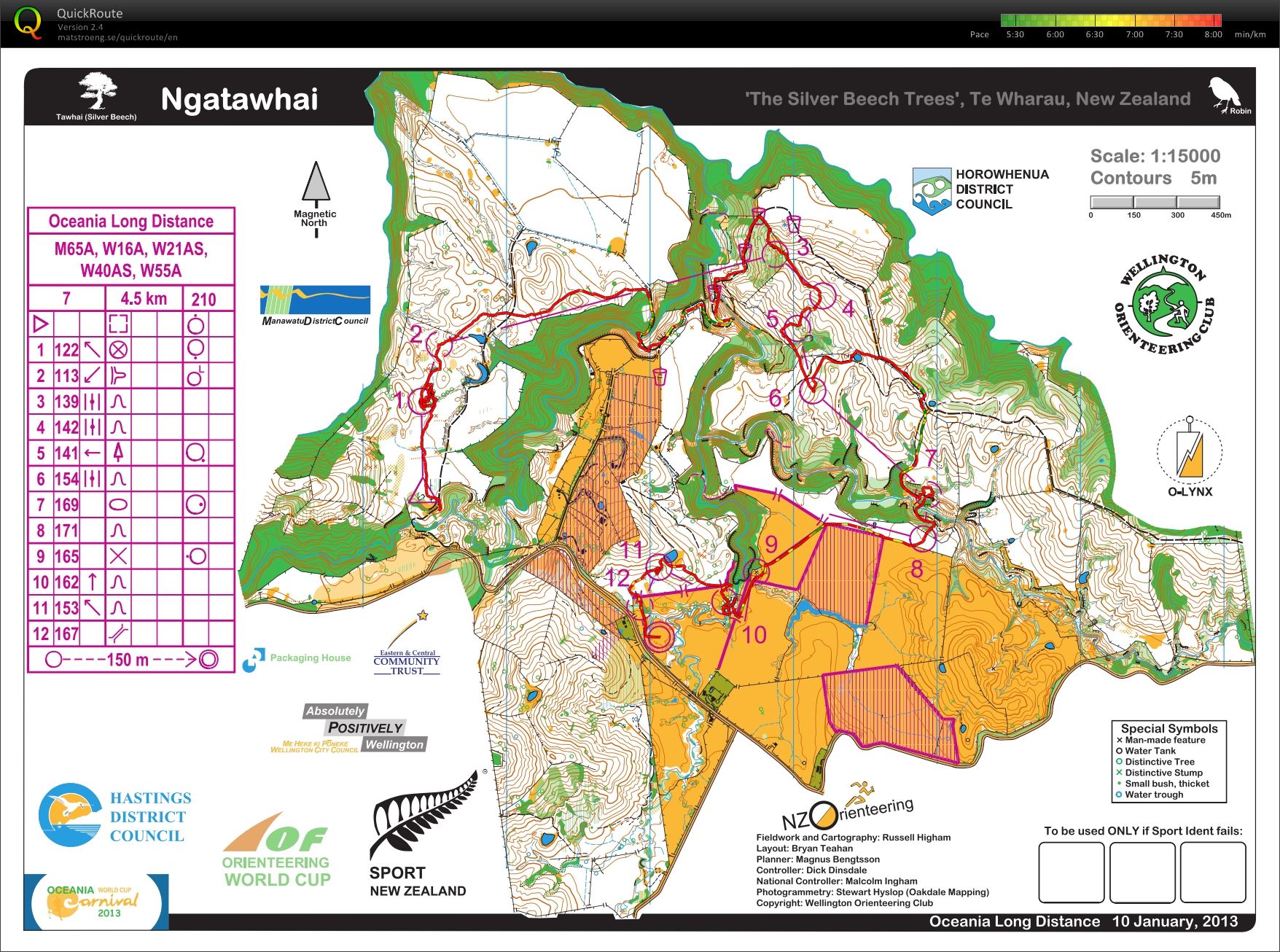
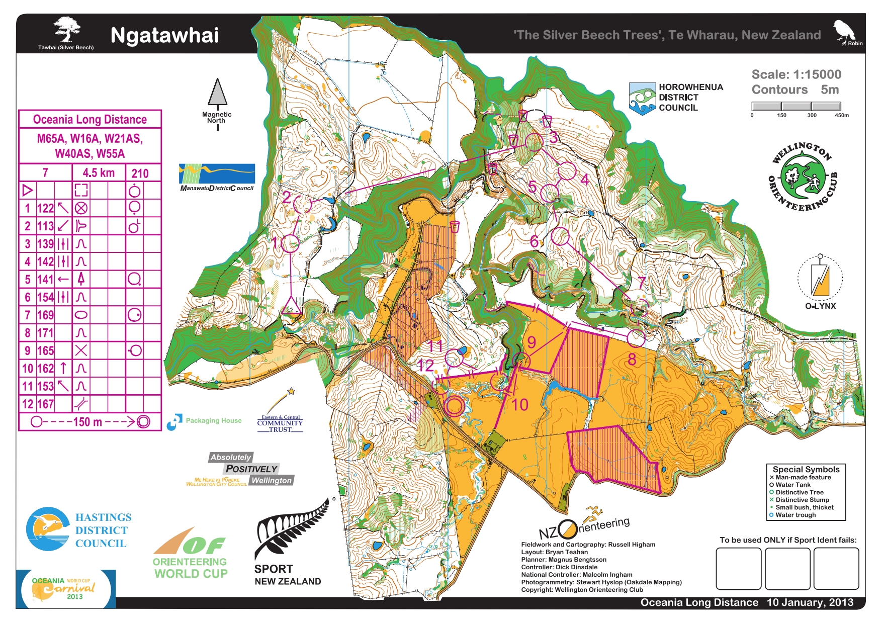
Race stats: 4.5 km, 210 m climb, 12 controls
Garmin distance: 4.73 miles with 275 m climb
Place: 22/27
Time: 1:58:36
Time lost: 14:19 minutes
Time per km: 26:00
Jumped into the pool at the motel when I got back. Refreshing!
Wednesday Jan 9, 2013 #
Note
http://www.flickr.com/photos/vmeyer/sets/721576324...
Eddie, we taped this just for you. Pretty cool, eh?!
http://www.flickr.com/photos/vmeyer/8361295168/in/...
Ah, a rest day! Feeling a bit worn out with the early mornings and late nights, coupled with more physical activity than I have done in a long time, so this rest day was well timed. I wasn't able to sleep in, so I sat under the trees and enjoyed the sunrise (and some free internet access).

Fish and chips for four. The fish was a bit tough, and Jane promised me the real thing once we were back in Hastings.

The leftovers before Callum arrived back from his run.

In the afternoon, we drove out to tomorrow's event site to setup. The heavy winds, promised for yesterday, were in full force today, so we dumped off the trailer but that was all.
Callum enjoying some down time.

A baby hedgehog. I was advised that they were disease carriers, otherwise I would have picked it up for closer inspection.

Tuesday Jan 8, 2013 #
Note
1. -Oceania Sprint race, suburban Wellington
2. -Oceania Multi-day Series Event 4
3. -World Cup Sprint Finals, Government House, Wellington
Masterton, Acorn Estate Motel
Note
http://www.flickr.com/photos/vmeyer/sets/721576324...
I like the last two of the girls finishing.
And maps with tracks:
http://www.flickr.com/photos/vmeyer/sets/721576325...
Can you figure out why I decided to go for a swim?
Orienteering race (Middle Earth - Sprint) 29:26 [3] *** 1.71 mi (17:13 / mi)
shoes: Black Brooks
A great atmosphere with the spectators sitting on the built in bleachers facing the cricket pitch.
A hot day, and with a 4 pm start, I was suffering a bit in the heat. Thank goodness Jane was able to drive me to the start, otherwise, I would have been done before I got there. It was a long, uphill slog on pavement in direct sun. This wasn't the last time that Jane drove me to the start during the events, and it was much appreciated each and every time.
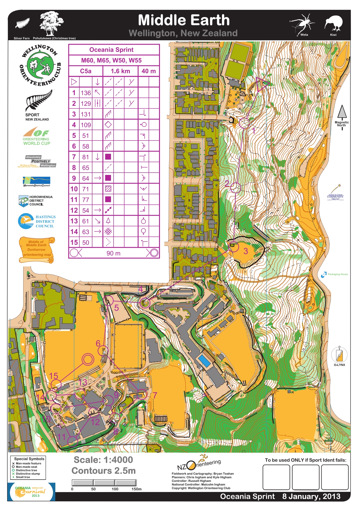
Terrain description: Parkland, playing fields and detailed school buildings.
First three controls in the woods, and then the rest were around the buildings. Lost a couple of minutes to 1, and then poor route choice/error to 4 and 10. Otherwise, I enjoyed running around the buildings and wished I were in better shape.
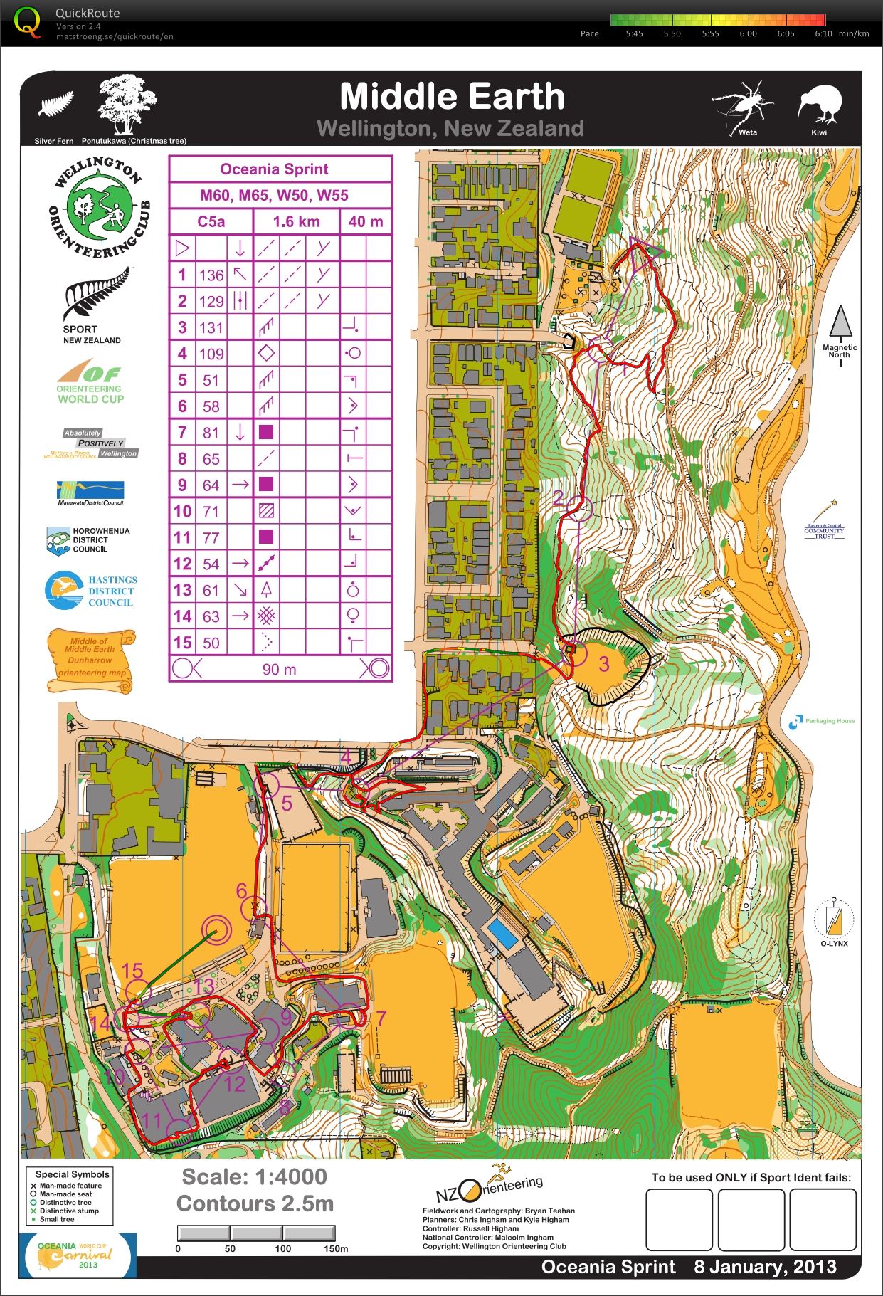
Race stats: 1.6 km, 40 m climb, 15 controls
Garmin distance: 1.71 miles with ? m climb
Place: 21/27
Time: 29:25
Time lost: 3:38 minutes
Time per km: 17:54
After packing up, Jane drove me to Mount Victoria for a panoramic view of the city.


Then it was off to the Acorn Estate Motel in Masterton.
Monday Jan 7, 2013 #
Note
1. -World Cup Sprint Qualification Race at Parliament, Wellington
2. -Oceania rest day Overnight: Johnsonville
We pulled into a new motel last night in Johnsonville, just outside of Wellington, the capital of New Zealand.
It took about an hour to get all of the sand out of my clothes. The antenna pole made for a fine drying rack.

No races for me today, though you wouldn't exactly call it a rest day. This morning, it was off to the Parliament grounds for the WC Sprint Qualifying races.

We set up in the pedestrian underpass but saw little action for the results screens,

since the real action was outside. It was good practice for tomorrow though.

 (Courtesy of P. Herries.)

Here is the map from the second part of the women's qualifier.
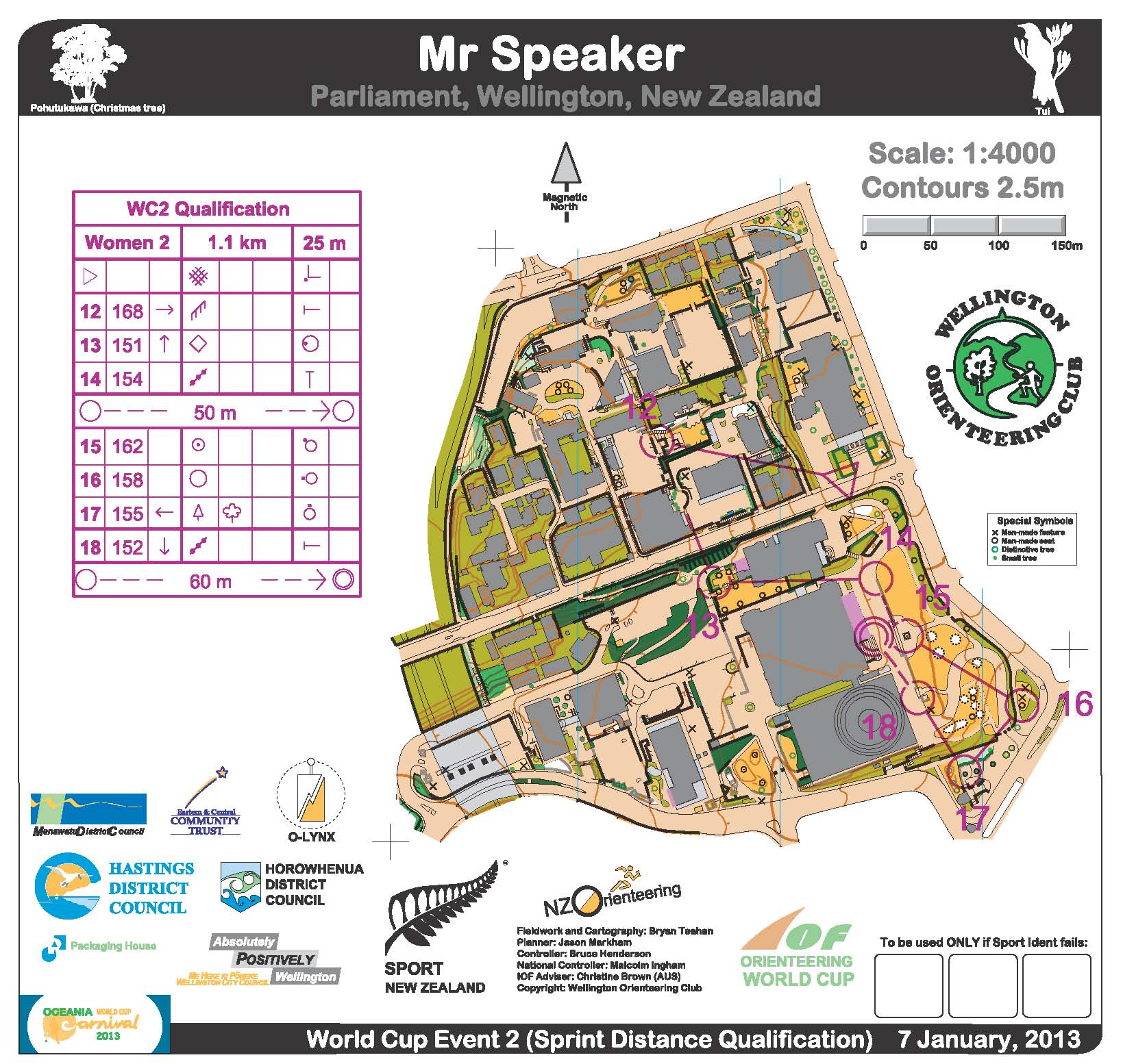
Besides unloading, setting up, and loading up again, I took a few trips down the hill to the facilities, so I'll call that my hill workout for the day.
Sunday Jan 6, 2013 #
Orienteering race (Middle) 1:20:53 [3] *** 2.95 mi (27:25 / mi) +5m 27:16 / mi
shoes: Another pair of new shoes!!


Monitors set up..

and tweaking things on the computer.

Magnus and Rob setting up the finish.

The country flags.

The SportIdent team, led by Rolf.

The large screen, part of the audio/visual package provided by (another) Phil. He had never been to an orienteering event, but he caught on quickly.

There was a great spectator area, though it was too bad that the spectator control wasn't actually out in the open.


Canadian, Carol Ross finishing the middle distance.

USA's Matt Scott running towards the finish.

The WC arena was wonderful with lots of open, flat area for the set up and spectating. Rick W. (USA) watching the action in the foreground.


Unfortunately, the start and finish area for the open races later on were across the river, so the action was more spread out. This allowed for some quiet time to refuel, and figure out was was wrong with the keyboard.

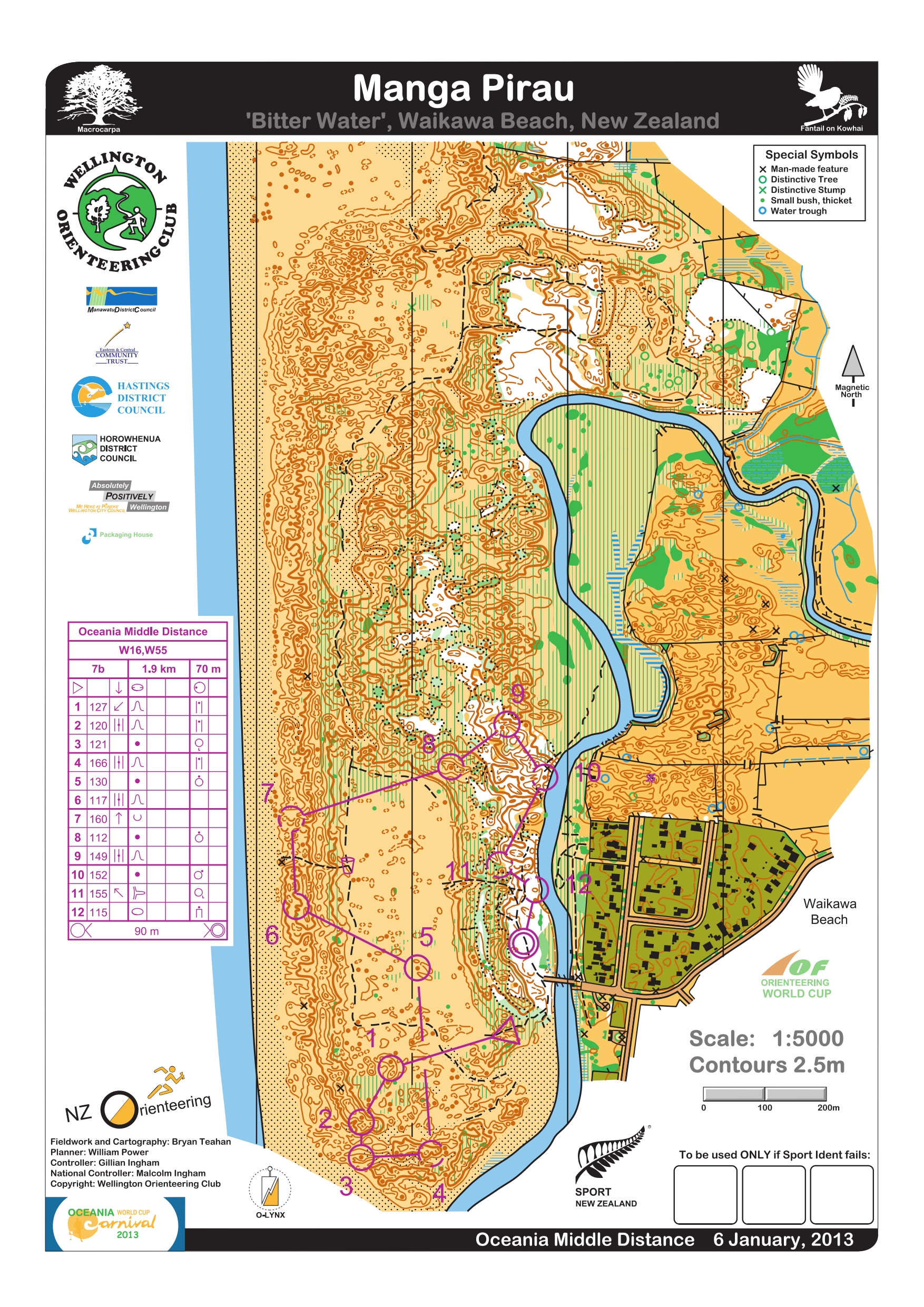
Terrain description: Complex Sand Dune terrain, including open dunes, both sandy and covered in marram grass and/or lupin, macrocarpa and radiata pine forest. Some areas of very intricate contour detail.
I missed my start and ended up going out near the end of the start window at 16:50.

Just a handful of W18 left besides me.

The start triangle


The first seven controls were in the sand dunes, and while I found #1 easily enough, I totally hosed #2, including having to make a steep ascent back up a dune to make matters worse. I pretty much was covered with sand by this time.

A torturous climb

Settled down for a few controls, and then had a mini adventure finding #7. At that point, I decided that I had sand everywhere already, so why not take a dip into the sea, and so I did.


Not wanting the news reports to talk about how I drowned while on an orienteering course, I only went in up to my hips and then let the waves splash up on me.
Post swim

Feeling refreshed, I headed off to complete the rest of the course. Unfortunately, I could not find #9, even though I tried to relocate from #10. Since it was getting close to the course closing time, I headed back in. I considered swimming across the river north of #12, but I sunk up to my knees in mud, so I abandoned that plan.
Failed to find all of the controls, but I gave myself a passing grade on the having fun part, finishing with a big smile on my face.

I have to admit that I was a bit smug when I saw the course distances for the events. I was relieved they were so short and with minimal climb, and I figured that I could finish that distance each day, even if I wasn't in top shape. Little did I know how the terrain would kick my butt each day!
Race stats: 1.9 km, 70 m climb, 12 controls
Garmin distance: 2.95 miles with 5 m climb
Place: MP
Time: 1:20:53 including walk to download
Time lost: 5 minutes to take a dip in the Tasman Sea, ~10 more at controls 1 & 7.
Time per km: n/a
I believe this is my favorite sequence of pictures - Jane, enjoying a hop and a skip.


Saturday Jan 5, 2013 #
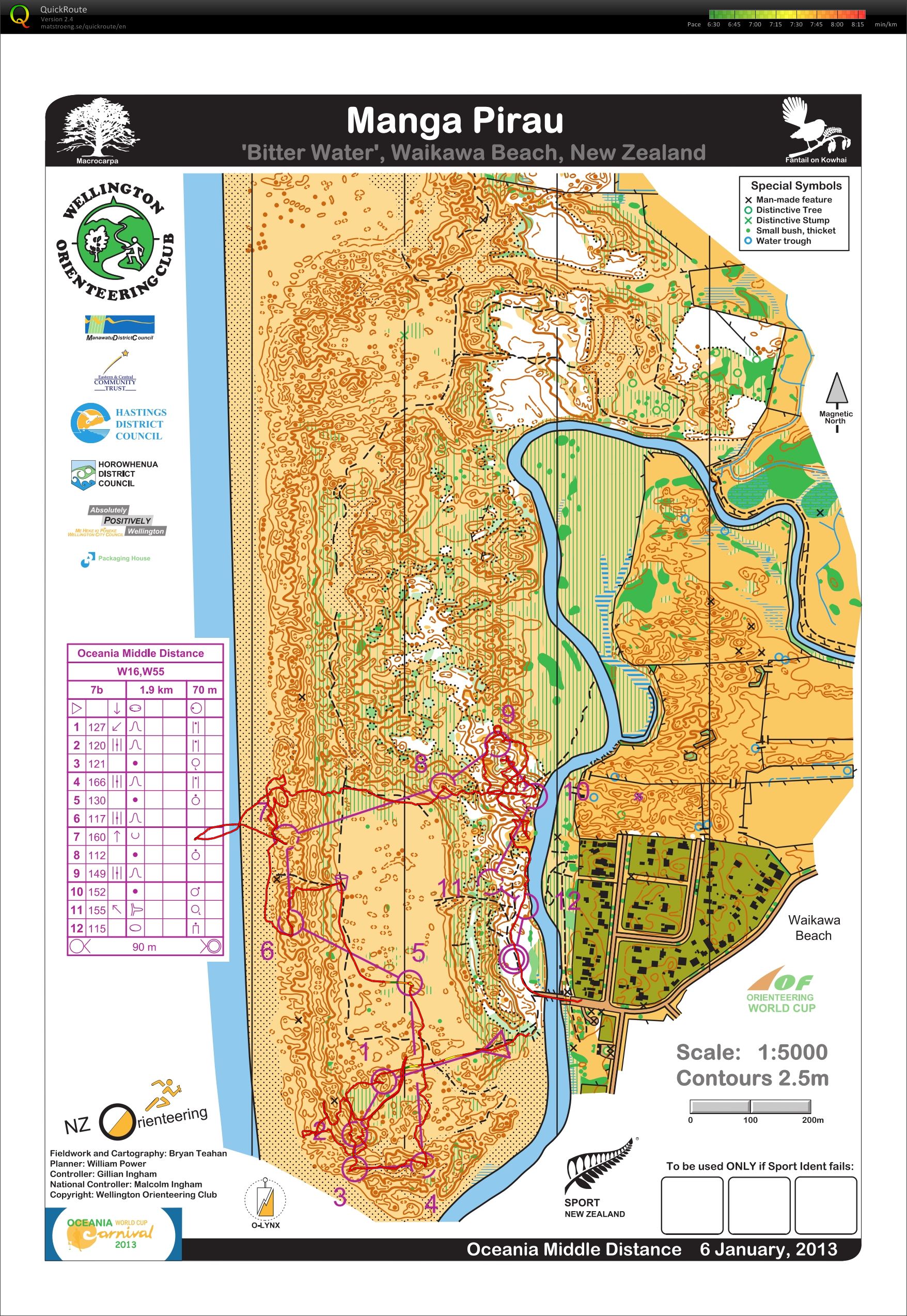
Orienteering race (Oceania Day 2) 1:15:06 [3] *** 3.57 mi (21:02 / mi) +3m 20:59 / mi
shoes: Another pair of new shoes!!

The tent setup.

The frog pond at the Finish.

Me, showing the run in to the Finish, and practicing not falling in when I finish later for real. There was speculation on whether someone (me) would end up in the pond.

Tim, whom I traveled with as well, getting the video camera set up.

The event director, burying cable.

Phillip and Tim consulting.

Tim's daughter, Sarah, who was there for the weekend events, but had to work the week in between. She was missed when she wasn't there, and not just for the fact that she was another set of hands.

Two Junior Girls finishing strong - note the extra arm on the right.

And, the two girls separated.

The Live Results - looking great!


Terrain description: Generally fast open mature pine forest on flat to rolling sand dunes. There is a coastal strip of macrocarpa trees (low visibility), and coastal dunes with mixed vegetation and variable runability, but good visibility. Parts of the forest were used for filming Ogiliath Wood scenes for the ‘Lord of the Rings: The Return of the King’ (2003).
Traded in the Moscow compass from yesterday for a Silva. I am used to the angle of the Silva. Didn't drift to the right as much today, and the error to 6 was because I went into the area with no real plan - well, I had a plan - just not a good one since the plan was that I would surely find the control someway, somehow. I knew that 8-11 would be tough, and I didn't give it enough respect and paid the price from 9-10 - I had no real plan which = Bad plan!! I eventually found a control, which was not mine and was additionally on the ground about 2 feet away from the control stand. Since I was not in the money, I stopped and removed my headband and secured the control to the stand. I found my control soon after, in much denser woods then I expected it to be, and finished strong after that. Tore around the finish on the inside lane, passing at least one, an maybe two other ladies, and I didn't even come close to falling into the water! Later on, I retrieved my headband from the control collectors, and it would be used for good on another day...
Race stats: 3.7 km, 35 m climb, 12 controls
Garmin distance: 3.57 miles with 3 m climb
Place: 25/28
Time: 1:15:01
Time lost: 14:24 minutes
Time per km: 20:22
At the end of the day, we showed that the monitor stand could be dismantled in about 90 seconds. Very cool!
Friday Jan 4, 2013 #
Orienteering race (Fusilier) 1:15:43 [3] *** 4.9 km (15:27 / km) +45m 14:46 / km
shoes: Another pair of new shoes!!
Once on site each day, the trailer was unloaded, the master radio was set up and Phillip would go put the radio controls out, while the rest of us would get the computers and monitors set up. Then the tweaking would begin.
Not many pictures from the first day. The 1st and 4th are courtesy of P. Herries.


Terrain description: generally fast open mature pine forest on flat to rolling sand dunes. There are some large open clearings plus some areas of marshes which can vary in runnability.
I started out poorly, not in tune with the map scale, and drifting to the right. Found 2 before 1, then navigated well from 2 to 1 and back to 2 again. Drifted to the right going to 4, so purposely adjusted when going from 9-10. Happy to quickly recognize where I was on the trail between 9 and 10, and was fairly clean the rest of the way. Really pleased with this effort, considering the few advanced events I have done in the last year. Also glad that I went with W55 and not W50.
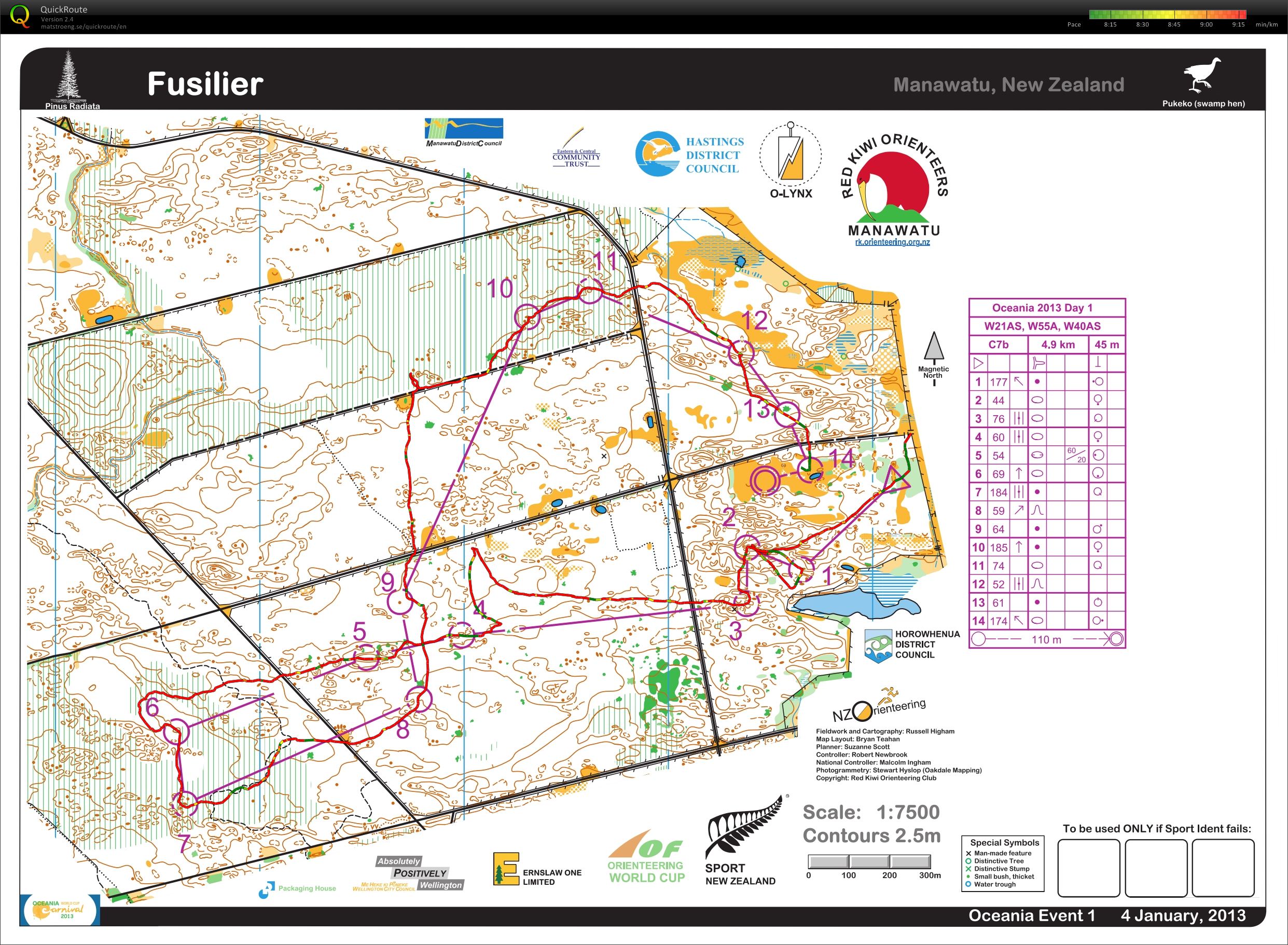
Race stats: 4.9 km, 45 m climb, 14 controls
Garmin distance: 3.91 miles with 11 m climb
Place 21/27
Time 1:15:43
Time lost: 6:42 minutes
Time per km: 15:27
A long day after breaking down the live results setup and moving it to the site for the next day. However, so happy to be traveling with such a fine group of people.
From here, we drove to the Welcome Inn Motel in Levin.
Thursday Jan 3, 2013 #
Running/Walking 1:00:00 [0] 4.21 mi (14:15 / mi) +6m 14:11 / mi
Today, the run/walk started from the motel in the opposite direction from yesterday, sometime after 6 AM. I didn't sleep as well last night as I had the night before, so an earlier start was no problem. Seriously, I just looked at the map of my route. I really need to be a little more aware of where I am! I had no idea that I was so close to the Napier Airport until I viewed the route later.

Struggled a bit more today. Had to change the walk to longer. Moving time was 60 minutes, 4.2 miles, with lots of time for picture breaks.
Because, today, I remembered my camera. However, it would not power on...a bit into the "run" I decided to check it again and discovered that the battery wasn't locked in, so I fixed that, and I was in business.
Some pictures of the bigger water (Hawke's Bay/Port of Napier?), as well as some of the pretty little gardens along the way, which were mostly made from materials reclaimed from the beach.


And, then a twofer - a New Zealand Christmas Bush and a bathroom (those who know me well, know why this has been noted here).


And, the bathroom building from the front:

And, a final look at the fine view...

Jane picked me up a bit before 9, and we headed back to load up the trailer and head off to the first event.
Tim resting with a "V" - a horrible tasting equivalent of Red Bull. The monitor stand is on the right side of the trailer, the main piece behind the white tables, and the legs sticking out next to the table. Would fit in the O'Mobile easy.

Callum, Tim and Phillip:

Phillip: pleased that it is all coming together after many months/years of hard work?

After the trailer was loaded, we all hit the road. The estimated time of departure was 11 AM, and I would not have been shocked if we had departed a couple of hours later then that, based on how long it takes me to load up. Glad I didn't place a bet...we were on the road just a minute or two after 11. First we drove into Hastings proper to purchase a color printer to replace the dead one on hand. After what seemed like forever, in this small business about the quarter of the smallest Best Buy, the employee found the requested item, and then Phillip and I were back on the road.
Route 2 South to Woodville, then over to Palmeston North, and then Fielding where the event center was. Hit the Subway on the way. Sorry, Roger. Picked up my packet and a southern hemisphere compass for NZ$95.
Then it was off to the meet site to set up for tomorrow. Setup included putting up the monitor stand and the antenna.


Off to the hotel in Fielding for one night after that.