Training Log Archive: NadimIn the 7 days ending May 23, 2022:
| |||||||||||||||||||||||||||||||||||||||||||||||||||||||||||||||||||||||||||||||
| « | » |
| » now | |||||||||||
| Tu | We | Th | Fr | Sa | Su | Mo | ||||||||
Monday May 23, 2022 #
Hiking (Street & Trail) 45:40 [2] 3.08 mi (14:50 / mi) +55m 14:03 / mi
slept:4.5 weight:205.7lbs (injured)
Bicycling (Commute) 11:09 [3] 2.56 mi (4:21 / mi) +30m 4:12 / mi
(injured)
Sunday May 22, 2022 #
Orienteering (Foot) 2:14:26 [3] 6.9 km (19:29 / km) +2144m 7:38 / km
(injured)
S-1 - I started going up the trail on the right, instead of the parallel trail on the left. I knew this immediately but rather than cut back, I look for an opening in the vegetation. That got me further past the control than expected, based on the vegetation mapping. I headed to some boulders but couldn't make sense of them--they were the wrong set of boulders. I cut back and found more and the control.
1-2 - I took trails to the field, then ran to a break in the thicker vegetation on the left. That got me to the road and to another trail. From a trail bend near a wall intersection, I attacked and got to the control. Another guy who had been running red and had started with me punched after me. I'd seen him leave the area of my #1 before I had, so I knew I'd gained time on him.
2-3 - I took trails to another bend and spiked it.
3-4 - Straight and I spiked it. The other guy whom I'd started (running Red) with got there after me.
4-5 - I started going straight, but I did drop below the wall east of the control when things didn't look as I'd expected. I cut back up quickly so I didn't lose much time.
5-6 - To the trail and taking that most of the way to the road, I got on the road. I was soon passed by the Red runner whom I'd started with. I was slow on the road and there was no water in the single gallon jug at the water stop. There originally wasn't going to be a water stop but with the day expected to be in the 90s F, the organizers did put some out. I went on and attacked the control from a bend to spike it.
6-7 - Back to the road, then in, going on the trail.
7-8 - Back to the road, then in at the first trail intersection. I hit this pretty well.
8-9 - I'd gotten confused by control #23 being along the way to #9. The leg line on the map leaving #8 was very stubby, before being broken. I found #23 without realizing it because I was looking for code 140 on #9. After circling, I realized I needed to go on and did. I got right to the boulder and spur below #9 but I incorrectly thought the boulder was the dot knoll for #9. I've seen other older maps with boulders mapped as dot knolls. Since I thought I was at the spur, I went north concluding that I must have been wrong. I got to the mapped cairn and it had a control on it. I looped back up to the trail, attacked again, and came to the same boulder below the spur. This time I went up the spur and found the control I had expected the mapped dot knoll to be more of a pile of dirt rather to go with the use of the point feature symbol. I would have tried to map that rise as a formline.
8-9 - I was having trouble reading the detail in the map, and the forest leaving #9 was thick. I got to the stream and concluded that I wouldn't cross where the footing was bad, the water flowing too much, and it being thorny. I didn't see the trail crossing the stream, thinking this was a series of cliffs. I went SW on the trail before crossing onto the island using small stones. I got back on trail leaving the island and getting to the bridge north of #10. With the leg line not being broken, I didn't see that there were 2 trail intersections. I took the second and looked in the wrong area. Quickly figuring out what I'd done, I corrected and found #10.
10-11 - I drifted a bit to the left but was close enough to see the control.
11-12 - I drifted a bit to the left but was close enough to see the control.
12-13 - Straight and I spiked it.
13-14 - I used the trail to the right and attacked from the bend to spike it.
14-15 - Back up the hill the way I'd come, I went straight and spiked it. The contour there seemed exaggerated. The reentrant was really shallow.
15 - 16 - Straight and I spiked it.
16 - 17 - I too the trail over the stream. I did get to have a cup of water at the bridge. I paused at the field where an old guy was keeled over. He'd started before me and told me he needed to take it easy because of his heart condition. He said he was okay so I went on. Trying to save distance, I came off the trail too soon when I saw some rocks. I'd gotten confused and hit the trail north of the control. It was hilly coming back.
17 - 18 - I used trails initially, but I did cut across the open broad reentrant later. I walked my way in from the pipeline ride
18 - 19 - I used the trail and left from a bend in the left fork to spike it.
19 - 20 - I was basically going straight.
20 - 21 - Straight.
21-22 - Straight mostly, but I did contour to the left occasionally.
22 - 23 - I went fairly straight, and having been there before I didn't lose much time.
23-F - I got to the road and came north after the out of bound's. I passed the fire circle, not being clear on where the finish was, so I came to the finish from the NE.
This was 9.2K for a 6.9K course.
Saturday May 21, 2022 #
Bicycling (Street & Trail) 2:34:04 [3] 27.5 mi (5:36 / mi) +152m 5:30 / mi
(injured)
We first biked over to Tony's Market where we got lunch sandwiches and drinks. We took those with us and went back to about where the ferry dropped us off. We rode Seaview Ave. going past marathon runners who were on the hiker/biker trail. We ate lunch at the Jaws Bridge.

Scenes from the movie Jaws were filmed in Oak Bluffs and around the island. We reached Beach Rd. and Upper Main St. in Edgartown. There we stopped to walk out to the Edgartown Harbor Lighthouse.

A couple were getting there wedding pictrues taken in the areas. Returning to the saddle, we went out Water St. and Katama Rd. to Mattakeset Herrring Creek and the fast eroding Katama South Beach.
We looped Atlantic Dr., to Herring Creek Rd., and Katama Rd. again. Turning left on Cleveland Town Rd., we Meshaket Rd., we passed many rural homes. We got onto a trail again at Edgartown - West Tisbury Rd., heading west. This got us to Manuel F. Correllus State Forest. That wasn't very interesting and the trail had regular bumps. The e-bikes had fat seats that were cutting into my hamstring while I pedaled. it got pretty uncomfortable at times. Eventually we got on Barnes Rd., and actually rode a few hills along Lagoon Pond. We got to an old part of Oak Bluffs on School St. at Pacific Ave. We wrapped up the ride through town on Dukes County Ave., Siloam Ave., and Lake Ave.
The ride and scenery were nice. It was good to see the runners. We walked some more to have some ice cream in town on Circuit Ave. before taking the ferry back. Martha's Vineyard was nice but it did seem overrated for the cost of things.
Friday May 20, 2022 #
Hiking 37:51 [3] 1.08 mi (35:03 / mi) +70m 29:12 / mi
(injured)
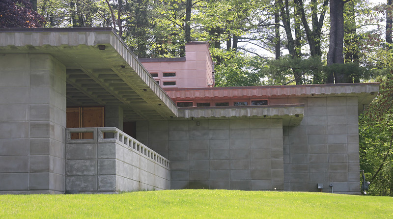
After flying-into Manchaster, NH in the early hours, Peggy and I saw the Currier Museum of Art (lots of nice stuff there)

and two Frank Lloyd Wright houses. We wanted to tour the houses but they were only giving private tours that day.
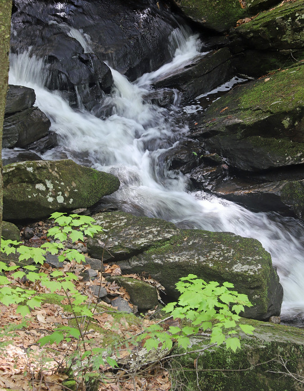
We were heading to Brattleboro, VT when we saw a little wayside stop. On a folly, we hiked the Chesterfield Gorge there--It was a nice set of waterfalls and cascading water. The trail was not very difficult and we took it at an easy pace.

Hiking (Trail) 32:09 [3] 1.0 mi (32:09 / mi) +64m 26:49 / mi
(injured)

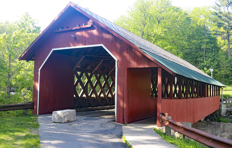
Later we saw the Creamery Covered Bridge. Peggy realized that we'd stopped very nearby just about by chance not long back, to get lunch. We'd been on the way by car to an orienteering further north back then. The bridge was okay.
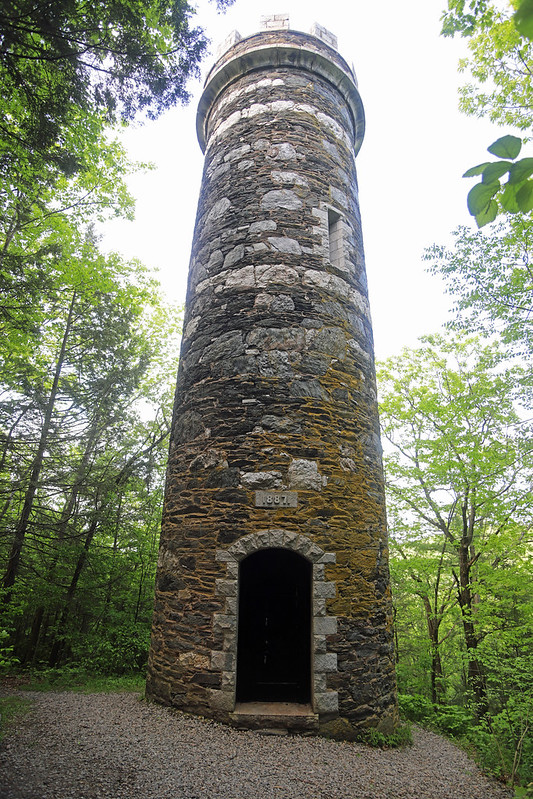
After this, we went to the Harris Hill Ski Jump/Retreat Farm Hike trailhead parking area. We didn't have a map with us and as the Internet comments had indicated, the trails were poorly signed and confusing. We eventually got to the top and the old Retreat Tower. Medieval looking, the tower was built in the 1880's. The tower also looks like a rook chess piece. We made our way back to the parking lot a different way and speculated about orienteering on this ridge.
We were fortunate to have enough time to eat back in Brattleboro at a bar overlooking the Connecticut River, just off of Rt. 119. The bar straddled the Vermont and New Hampshire border. It had a line painted on the floor to indicate where the border was. My shrimp tacos were were good!

From there we rushed to Putney VT and got to see Cheryl Wheeler in concert with Kenny White. Both were good. The crowd, as usual, was pretty old We'd tried to see Cheryl Wheeler back in December but that concert had been cancelled. To finish-up the night, we drove about 2 hours and into a thunderstorm, into Chelmsford, MA where we were finally able to rest. It was a full and wonderful day!
Thursday May 19, 2022 #
Hiking (Street & Trail) 48:53 [2] 3.3 mi (14:49 / mi) +42m 14:15 / mi
slept:5.5 weight:206.1lbs (injured)
Wednesday May 18, 2022 #
Hiking (Street & Trail) 50:00 [2] 3.43 mi (14:35 / mi) +60m 13:49 / mi
(injured)
Tuesday May 17, 2022 #
Hiking (Street & Trail) 49:58 [2] 3.34 mi (14:58 / mi) +42m 14:24 / mi
(injured)