Training Log Archive: NadimIn the 7 days ending Sep 25, 2021:
| ||||||||||||||||||||||||||||||||||||||||||||||||||||||||||||||||||
| « | » |
| » now | ||||||||||
| Su | Mo | Tu | We | Th | Fr | Sa | |||||||
Friday Sep 24, 2021 #
2 PM
Orienteering (Field Checking) 3:18:10 [1] 4.65 mi (42:37 / mi) +49m 41:16 / mi
slept:5.0 weight:197.3lbs (injured)
Hoyles Mill Conservation Park, MD. Starting at the Soccerplex, I walked out with Sam Listwak to some locations on the map needing updating. I'd missed a few features and added them. A few things were changed. Sam is setting the QOC NRE here scheduled for early December. I was going to do some more, but one section was too far off, and the other I wanted to get to wasn't on the page I'd printed. There was stilt grass everywhere we went. It should be gone by the time of the event.
Sunday Sep 19, 2021 #
Event: QOC Lake Accotink
12 PM
Orienteering (Foot) 59:07 [3] 3.4 km (17:23 / km) +165m 14:00 / km
slept:7.5 weight:196.5lbs (injured)
QOC: Lake Accotink Regional Park, Springfield, VA. I walked the Brown course since I'm not supposed to run for now. I didn't lose much time but I wasn't really clean with navigating either. I'd forgotten how general the contours were there. Full leaf vegetation and it being greener than mapped didn't help, though I 'd expected and had been warned about that. Brown had a 1:5,000 scale map which made the small misalignments seem to be more. Though there are lots of trails in this park, I didn't use them a lot.
S-1 - I didn't really like the contours for this area. I'd come through the forest rather than back-door it off of the trails on the other side. I came up the wrong spur. I probably lost a minute or more.
1-2 - I went right to it while staying in the woods the whole way. It was hard to read the trails with the green on the map being much darker than current ISOM 2017 standard.
2-3 - I used the main trail for this one and went right to it. Max was just getting there ahead of me, on the green course.
3-4 - I again stayed off the main trail for this one but once back in the woods, and back to the smaller trails, they didn't make a lot of sense to me. When I realized that a smaller trail was not going where I wanted to, I got off and took a bearing to get to the right trail. The second time this happened, I followed the wrong trail again. Eventually I got too high and paused. From a higher vantage point over a reentrant, I could see a control. I think that one worked. I probably lost 2 minutes on this.
4-5 - Straight, but I found myself a bit to the left side of the knoll. I adjusted and spiked it. Max was leaving the area as were others.
5-6 - I went basically straight--I crossed the stream in just the right place to spike it.
6-7 - Straight but I used the trail initially. I got there ahead of a guy who'd been standing on a fallen tree and looking ahead. The reentrant feature and control was right in front of him.
7-8 - I lost track of the trails and just where I was on this leg very quickly. All was well as I moved in the general direction. I popped out on a hilltop just above the main trail. Using the main trail, I went south and cut left with 1/4th of the way to go. That trail petered out or became overgrown so I went straight again. I went right to the sewer that I thought the control was on. Not seeing it, I looked ahead and saw another sewer with a control on it. I went there across some damp ground and punched. It was 102 when I was looking for 120. I wondered about it being the wrong number. Looking back, at the first sewer, I "knew" it should be on that sewer so I went back again to be sure. Coming from this direction, I saw the control on a nearby ditch that matched the control description--my bad! I probably lost 2 minutes.
8-9 - I went straight to keep the distance short. This got me to the trail better than I thought it might, because of the dark green mapped vegetation. Using the trail bends to pick where to leave the trail. I cut right before the bench, and spiked the control.
9-10 - The woods were just slow enough, and the control low enough that I thought it'd be faster using the main trail and coming up to the rootstock.
10-F - Down the trail to the finish.
Overall, I didn't feel that great about this effort. The fastest finish time was 38 minutes--a junior who usually runs Green and Red. I got 7th, which for just walking isn't that bad. I just would have liked to have been more accurate, and been better able to read the trails on the map. A map update would help. I covered 4.474K on the 3.4K course. My climb was 130m for it while it was rated at 165m.
Bicycling (Mountain) 45:00 [3] 4.0 mi (11:15 / mi)
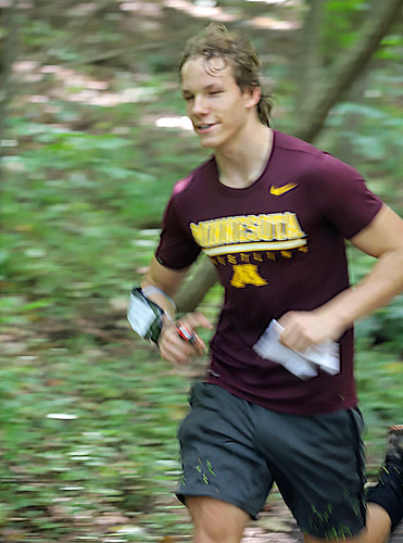
Lake Accotink, VA. From the McLaren-Sargent Pavilion, I rode around taking pictures of orienteers. Most had finished so I didn't get as many pictures as I would have like to. It was nice to have my bike to do this though it was a little awkward at time with my camera and a long lens hanging on my neck. I stayed on the main trail mostly, but I did get to one side trail before turning back where a tree blocked the trail.

Orienteering (Control Pickup) 25:00 [2] ** 1.4 mi (17:51 / mi)
spiked:5/5c (injured)
Lake Accotink, Springfield, VA. From the McLaren-Sargent Pavilion I picked-up 4 controls and the finish control stand. Riding the bike got me close enough to walk-in. I usually stashed the bike on a side trail or in the woods. I didn't have any control bags or a backpack. I tied together the strings for the controls, and held onto the bags in my hands. I had one control stand and for the finish horse, I folded it, hung it on the handlebars of my bike and held a sign that went with it. It was awkward, but it worked. I even made it up the semi-steep hills on either side of the dam.