Register | Login
Attackpoint - performance and training tools for orienteering athletes

Training Log Archive: Nadim

In the 7 days ending Aug 29, 2020:

activity # timemileskm+m
  Hiking8 15:56:42 27.15(35:14) 43.7(21:54) 1521
  Running1 23:32 2.31(10:11) 3.72(6:20) 51
  Total9 16:20:14 29.46(33:16) 47.41(20:40) 1572
averages - sleep:6.3

«»
4:49
0:00
» now
SuMoTuWeThFrSa

Saturday Aug 29, 2020 #

Note
(rest day)

Travel Day. We got home at around 8:30pm. I felt it best to just rest. Our cats were happy to see us.

Friday Aug 28, 2020 #

9 AM

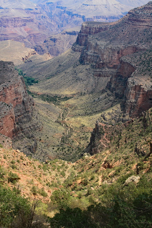
Hiking (Trail) 3:56:50 [3] 7.67 mi (30:53 / mi) +592m 24:54 / mi
slept:6.5

Grand Canyon National Park. From Rte. 64, Max and I hiked to the trailhead for the South Kaibob Trail and found several Rocky Mountain Elk there. A rangers explain that they’d been introduced and were considered invasive. They also were not fully adapted to the drier climate of the Grand Canyon. The elk looked to get access to water from tourists like us. I felt a little bad for them but proceeded down the canyon to Skeleton Point. We ate lunch there while watching the Colorado River another 2,400 ft. below. Skeleton Point was 2,,040 ft. below the rim at the trailhead. Much of the trail involved stepping over wooden erosion prevention logs or on what amounted to cobblestones. A raven joined us while we ate. The trail going down was nice but starting at almost 10:00am it had already started warming up. We quickly warmed more as we climbed on the return. The views were better than on the part of the Bright Angel Trail that we’d done the day before, because much of the hike was on a ridge. As we climbed clouds moved in helping to cool us off. I was finding that my pulse was about 150 bpm on the steepest trail segments. The clouds keeping it cooler helped me a lot from Cedar Ridge to the top. After reaching the rim again we hiked the rim trail towards Rte. 64. We’d had spotty cellular service in the canyon but none at the top. Peggy knew about the lack of cellular service so she’d hiked out with Samantha to meet us. We all finished together.
IMG_9233_GCanyonSKaibobTrSkeletonPoint_AdjCrop
Max and I enjoyed our little adventure. It was a fitting activity for our last full day of vacation. Though my left knee aches a little now as I write this, we both felt that had we had more time we could have made it down to the river and back up the Bright Angel Trail. Max is young enough that he might do it in the future. It’s less likely for me. After all, it took me 58 years to get here for the first time. However, I’ll enjoy the memory of this hike, and my time with Max.

Thursday Aug 27, 2020 #

11 AM

Hiking (Trail) 2:23:32 [3] 3.9 mi (36:48 / mi) +344m 28:53 / mi
slept:6.0

Grand Canyon National Park. From the Thunderbird Lodge, to the Bright Angel Trail, to the 1.5 Mile point, and back. Peggy, Max, and I did this hike, starting later than intended. Max and I had planned to go down the South Kaibob Trail a ways but decided against that with the late start and expected heat. Samantha did a rim hike. The trail was not bad at first; not too steep. It got steeper past the first major reentrent and kept the same slope. We dropped 1,200 feet, only 1/3 of the drop to the river. This was also about 1/3 of the way there. There was unexpected water at our turnaround point—a pipe with a valve. On advice of a ranger we’d met on the way down we got our clothes wet to cool us for the hike back. It worked for a while. Max took off climbing fast. Peggy an I took our time and rested along the way. We were still going up with 15-20 minutes more to go when Max texted us letting us know he was already in the hotel room. He’d run part of the way up. I got some good pictures. It was scenic all the way but the hiking was nicer and more varied in Bryce. We had lunch along the rim afterwards and later a rain storm came creating great views with rainbows into the canyon.
IMG_8950_GrandCanyonBrightAngelTr_Adj

Wednesday Aug 26, 2020 #

10 AM

Hiking (Trail) 13:43 [1] 0.59 mi (23:14 / mi)

From the Horseshoe Bend parking lot to Horseshoe Bend. The hike was hot but shorter than expected. This was a pay area--the lot was smaller than lot in the local parks in Montgomery County MD. and there was a toll-like entry taking in up to 3 cars at a time. I was a little soured by the $10 entry fee for what seemed like a small service (satellite imagery suggests that the changes were recent) but not by the views of the gorge. Though the area seemed to be run by the National Park Service, Peggy's National Park pass did not gain us free entry. They more than made up for the entry fee. The stark contrast of the green-blue water 1,000 ft. below, against the red cliffs was awesome! On top there were Navajo Sandstone formations. I spent more time photographing the sandstone than I did for the gorge. The sandstone was sharper here than in most of the parks we'd seen earlier (except the upper parts of Zion) and had similarities to the pictures I'd seen of the crazy cool sandstone of Vermilion Cliffs National Monument. Though we'd tried, we'd planned our trip too late to even get into the lottery for Vermilion Cliffs National Monument, so seeing sandstone that was similar really made this a great find for me. The light was in a pretty good position for photos too.
IMG_8748_HorseshoeBend_AdjCrop

Hiking (Trail) 25:00 [1] 0.7 mi (35:42 / mi) +26m 32:04 / mi

From Horseshoe Bend to the Horseshoe Bend parking lot. After a great time on the rocks and enjoying the views I walked back. Samantha was dragging her feet and even said she couldn't make it. Though it was getting warm, it was not that hot. I waited but eventually I got her moving.
IMG_8800_HorseshoeBend_Adj
3 PM

Hiking (Trail) 34:38 [1] 0.7 mi (49:27 / mi) +22m 45:05 / mi

Wupatki National Monument, AZ. With our plans a little disrupted by closed roads on the short route to the Grand Canyon, I'd found that we were passing this cool area. The ruins had similarities to cliff dwellings that I'd seen only these were on a very small ridge almost on a plain. There was also a ball playing area that a sign said reflected a Mexican influence. However, one of the coolest things was a blow hole. It was hot out and similar to our Paris experience last year, cold air was being forced up from the ground. The difference was that this cold refreshing air was coming out naturally. A sign explained that pressure changes in an underground cavern was making it happen. The air came out steady and as hard as it had in Paris. The sign also indicated that there were other blowholes in the area.
IMG_8815_Wupatki_Adj

Hiking (Trail) 16:28 [1] 0.34 mi (48:27 / mi) +6m 45:53 / mi

A short drive away in from the Visitor Center for the Wupakti National Monument was another Pueblo ruin. This one was called Wukoki Pueblo. The trail led right into the structure. There were some doorways that even Samantha had to duck down to get under. There are supposed to be many other similar structures in this national monument. We didn't have time to see them however, we did drive forward on the road toward Flagstaff, and passed the Sunset Crater--old volcanic activity but clearly recognizable with lots of cinder and rough lava. Flagstaff was quite unexpectedly forested--wierd after crossing hot plains for hours while heading south. In the town an on the way to the Grand Canyon through the National Forests we saw open pine forest terrain that reminded us of Colorado. It looked great for orienteering!
IMG_8858_Wupatki_AdjCrop
11 PM

Running (Trail) 23:32 [3] 2.31 mi (10:11 / mi) +51m 9:32 / mi

Grand Canyon National Park, AZ. After traveling most of the day, Max and I got out for a nighttime run. We left from the Thunderbird Lodge on the south rim of the Grand Canyon. The rim trail was paved here, and for about 18 miles in total. As soon as we'd stepped outside, we saw elk about 10 ft. away. They seemed to be enjoying the greener grasses around the lodge, or perhaps safety from predators. Max and I went around them and used headlamps for a while. A better than quarter moon was shining so we turned-off the lights after a while. We were starting under 6,900 ft. elevation and going east, the trail climbed almost the whole way. I felt it but Max was cruising along. He wanted to go longer but with a big hike planned, I thought it best to not push it. Using the moonlight we could see out into the canyon. It was much. With the temperatures in the upper 60s F and a breeze it was some of the best weather we'd had. Coming back was easier but I wasn't much faster.

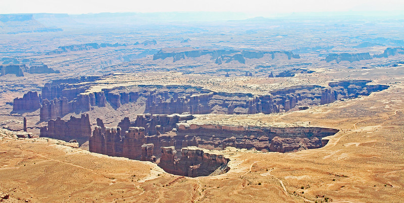
Tuesday Aug 25, 2020 #

Note

Today was mostly a travel day driving from Moab, UT to Page, AZ. Along the way we stopped at several places including Newspaper Rock (petroglyphs), Sand Island Park (petroglyphs), the town of Bluff, UT, Valley of the Gods, Moki Dugway, Muley Point, and Monument Valley. We drove past while seeing the famed Mexican Hat balanced rock. We took pictures just about everywhere and did what we could to re-enact the running scene from Forest Gump (the road was not totally quiet, the sun was low in the direction of the mesas and on our backs, and there was still a haze in the air from the far, far off California wildfires. This was beautiful country. The Navajo Nation showed signs of poverty but the people we met were nice. Between Kayenta and Page we saw some awesome terrain for orienteering where there was scattered Navajo Sandstone—very picturesque. We also saw a mountain goats in that area.

Newspaper Rock
NewspaperRock_Panorama1

Sand Island Petroglyph Panel
IMG_8591_SandIslandPetroglyph_Adj

Valley of the Gods
IMG_8600_ValleyoftheGods_AdjCrop

Monument Valley
IMG_8669_MonumentValley_Adj

Monday Aug 24, 2020 #

8 AM

Hiking (Trail) 47:55 [2] 0.92 mi (52:04 / mi) +28m 47:32 / mi

Canyonlands National Park, UT. Mesa Arch Trail. We got up to the park from Moab early enough to reach the arch while it was relatively cool and there was still an orange glow of the rising sun on the ceiling of the arch. I had my full compliment of camera and video gear so I was feeling the brief rise from the parking lot as my legs warmed up. What was worse was waiting for people to clear away from the arch. It seems to be a cultural thing for ladies and young women to do a model shoot. A young blonde woman in hot pink tights got there seconds ahead of us and posed away. When she was done other people came and were under the arch for a more normal time. A young family from Oregon with a young woman in a dress came next. It was hard to work around the stream of people while the light was changing quickly but I think I got both good images and video. It really was a great arch, smaller than I’d imagined at only a 9-10 ft. ceiling but more personable. The incredible canyon below with spires was an incredible backdrop. It instantly became one of our favorite sites of our vacation.
IMG_8399_MesaArch-AdjCrop

Hiking (Trail) 1:08:00 [3] 1.8 mi (37:47 / mi) +84m 32:58 / mi

Canyonlands National Park, UT. A short way away from the Mesa Arch hike was the Aztec Butte Trail. While Peggy and Samantha headed on the left fork to the historic granary ruins, Max and I went further up the Aztec Butte. This was a bit of s rock scramble though most of the climb was on steep but smooth white Navajo sandstone. It was a little trickier to climb with my camera mounted on my monopod in one hand. The top of the butte was classic flat and open terrain. Max and I saw a deep canyon below that we hadn’t even realized would be there. Going down on the same trail that we’d come up was trickier and required me to use the classic but slides-butt technique at the crux.

Max and I’d decided to climb up the smaller hill to see the old granary. It was tucked into a natural overhang with the walls made of stone bricks.
IMG_8478_AztecButte_Adj

2020_Canyonlands_HD1080_H.264
12 PM

Hiking (Trail) 1:20:55 [2] 2.11 mi (38:21 / mi) +45m 35:58 / mi

Canyonlands National Park, UT. After visiting parking and overlook ares for Upheavals Dome and the Green River, and we hit the Grand View Overlook trail. This gave excellent views of both the Colorado and Green River canyons , complete with white rim of sandstone and lots of towers. It was 94 F but felt hotter. It later hit 106 F in Moab. We took our time for the most part.
IMG_8514_GrandView_AdjCrop

Sunday Aug 23, 2020 #

8 AM

Hiking (Trail) 1:55:31 [2] 3.51 mi (32:55 / mi) +128m 29:33 / mi

Arches National Park. The family started our day with a hike to the Landscape Arch view point (World’s longest natural arch at 306 ft.). We went a little beyond that to a primitive trail rock scramble up a rock fin that gave us an elevated view of the same arch. This was a part of the longer Devil’s Garden Trail hike. On the way back we saw Pine Tree Arch and one more.
IMG_8184_DevilsGardenTrail_LandscapeArch_Adj

Hiking (Trail) 44:05 [1] 1.04 mi (42:23 / mi) +45m 37:25 / mi

Arches National Park. We walked from the parking area to Turret Arch, then to the South Window Arch. It was hot out but we took it easy and took lots of pictures.
IMG_8289_TurretArch_Adj

Hiking (Trail) 10:21 [3] 0.34 mi (30:27 / mi) +7m 28:36 / mi

Arches National Park. This was little more than stretching our legs away from the car. We got a closer look at the famed Balanced Rock.
IMG_8306_BalancedRock_Adj
6 PM

Hiking (Trail) 1:59:44 [3] 3.53 mi (33:55 / mi) +194m 28:58 / mi

Arches National Park. We ended our day with a hike to the Delicate Arch. Our timing was good to get us there for the sunset but with California wildfire smoke in the air and some clouds, the effect was muted. We did see a bunch of other people hanging out on the slickrock. There was a line for people who wanted to get an excel picture under the arch. One lad came in a red dress and was jumping into the air for her photographer. We saw and watched with the crowd as another photographer dropped his camera. It went sliding and bouncing it’s way to the bottom for what seemed like 10 seconds. The guy and his buddy retrieved the main body only after a difficult to watch and daring scramble down a steep portion of After sunset we made our way down with lights. Others were heading up in the dark.

2020_ArchesNationalPark_HD1080_H.264

« Earlier | Later »