Training Log Archive: NadimIn the 7 days ending May 25, 2013:
| ||||||||||||||||||||||||||||||||||||||||||||||||||||||||||||||||||||||||||||||||||||||||||||
| « | » |
| » now | ||||||||||
| Su | Mo | Tu | We | Th | Fr | Sa | |||||||
Saturday May 25, 2013 #
2 PM
Hiking (Backpacking) 1:52:57 4.2 mi (26:54 / mi) +233m 22:56 / mi
slept:4.9 weight:181lbs
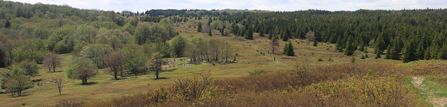
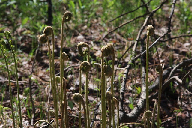
Dolly Sods Wilderness, WV. From Forest Rd. 75, Bear Rocks Trail (TR 522), to the Raven Ridge Trail, (TR 521), to the Bear View Trail (TR 523), then off-trail to the Dobbin Grade Trail (TR 526) near the west fork of Red Creek.
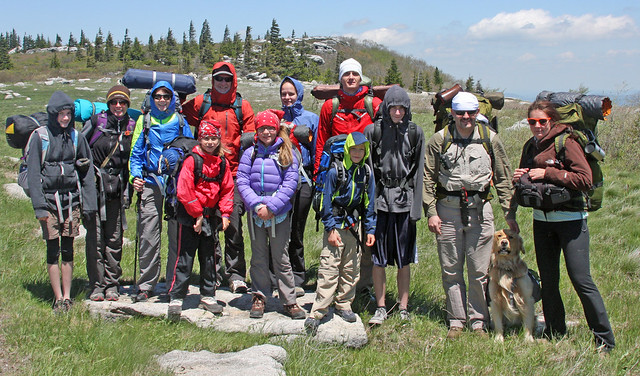
A whole cast of characters went including: Peggy, Max, Kathleen L., Greg L., Max L., Nicole L., Johan Astrom, Kattis Astrom, Jan M., Dasa M., Alexis M. Benny M., and Kate (a friend of Alexis). It was cold and windy for late May. The temperatures were probably around the upper 40s F starting out and the winds were gusting to around 25mph.

We moved along well, passing a couple of other groups despite moving at the kid's speed. None of the trees were in flower yet but there were occasional ground flowers.
With the wind, staying up high was not a good option. We went off of the Bear View Trail at the spur and made our way down toward the marsh, trying to follow an intermittent trail that had really disappeared.
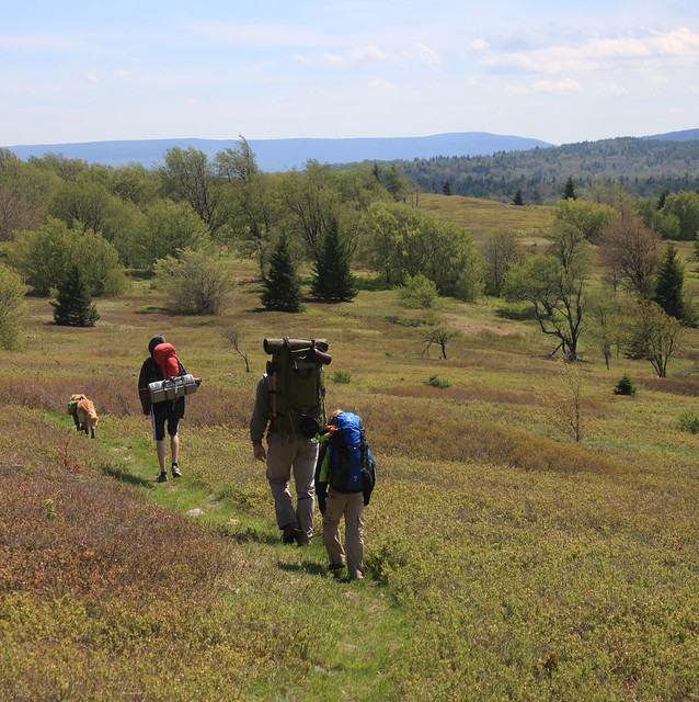
The prime campsites had been taken when we got to the Dobbin Grade Trail. My GPS track at the end shows my wanderings in trying to locate a better place but we settled on one in the trees. Dinner was good as it always must be when backpacking. We huddled around a fire burning big. The winds died down a bit but wispy clouds and a just past full moon kept us from seeing a lot of stars. The temperatures were supposed to drop down to 31 F. Some were less prepared for this but Peggy, Max, and I were cozy in our bags. Max would sometimes break the silence as he screamed out excitedly in his sleep.
A whole cast of characters went including: Peggy, Max, Kathleen L., Greg L., Max L., Nicole L., Johan Astrom, Kattis Astrom, Jan M., Dasa M., Alexis M. Benny M., and Kate (a friend of Alexis). It was cold and windy for late May. The temperatures were probably around the upper 40s F starting out and the winds were gusting to around 25mph.
We moved along well, passing a couple of other groups despite moving at the kid's speed. None of the trees were in flower yet but there were occasional ground flowers.
With the wind, staying up high was not a good option. We went off of the Bear View Trail at the spur and made our way down toward the marsh, trying to follow an intermittent trail that had really disappeared.
The prime campsites had been taken when we got to the Dobbin Grade Trail. My GPS track at the end shows my wanderings in trying to locate a better place but we settled on one in the trees. Dinner was good as it always must be when backpacking. We huddled around a fire burning big. The winds died down a bit but wispy clouds and a just past full moon kept us from seeing a lot of stars. The temperatures were supposed to drop down to 31 F. Some were less prepared for this but Peggy, Max, and I were cozy in our bags. Max would sometimes break the silence as he screamed out excitedly in his sleep.
Wednesday May 22, 2013 #
8 AM
Bicycling (Commute) 38:48 12.0 mi (3:14 / mi)
slept:5.75 weight:179.5lbs
From Northfield Rd., Bethesda, MD, then to 12th and C St. SW, Washington, D.C. Having dropped-off Max earlier than usual, I was able to go directly to work without having to slow down to go his pace. I moved well but slowed down for other things. I'd been busy Monday and didn't get a chance to run then. I picked-up my bicycle from the repair shop yesterday evening and so I lost time for that. The repairs involved replacing by brakes/shifter with a new but inferior product. It took some getting used to and some shifting adjustment is needed--at least I have a functional road bike again. I caught up to a rider at the traffic light at Bradley Rd. and that got me moving quicker than I had planned. He stayed with me, drafting, until perhaps somewhere before Georgetown. There were headwinds but it was warm and I went faster than I have in a long time. After Georgetown, the headwinds slowed me more.
5 PM
Bicycling (Commute) 43:52 12.3 mi (3:34 / mi)
From C St., SW, Washington, D.C. to Beach Dr., to Beach Dr. just before East-West Hwy. in MD. I rode up to see the end of Max's soccer practice. I left amid traffic but followed a bus around the Tidal Basin before passing it. At times I was doing 28mph in its draft but other times, I had to wait as it shimmied it's way through narrow spots and through intersections. This was a pattern to be repeated as I headed up Rock Creek. The tailwind would sometimes be lined-up with the valley enough to push me along. The draft of cars also helped. However, I also got stuck behind long lines of cars before the zoo and elsewhere. Each time I was able to accelerate going up the valley to high speeds, I was not sure if it was being rested, having a new drive train on my bike, or the wind. Part of it could have been the difference in expectation of effort, in comparison with the mountain bike I rode last week. It was like interval training. I still wished the bike would shift better. It was like a summer day--a nice cooler one that was humid. Dinner with Peggy and Max afterward was nice too--Peggy treated!
Sunday May 19, 2013 #
Event: QOC Mason Neck
12 PM
Running warm up/down 5:48 [2] 0.58 mi (9:55 / mi)
slept:8.75 weight:180lbs
QOC: Mason Neck, VA. Warm-up around the field at the start.
Orienteering race (Foot) 1:14:57 [4] **** 9.3 km (8:04 / km) +210m 7:14 / km
spiked:12/15c
QOC: Mason Neck, VA. This was a somewhat satisfying day. I didn't start off that well. I took a risk going a straighter path to #1, and missed to the left. It was easily corrected but not without having lost 30 seconds. The miss made me be more careful but staying off the trail also helped me have longer to adjust to the flatness of the map before some of the longer legs. I thought to aim-off for #2 but perhaps I did so too much. I also lingered when I should have been running faster along the reentrant to the control--I had just enough doubt that I wanted to make sure I didn't miss it.
Going to #3, I did a version of what just about everyone else I'd talked to did. I ran up the dirt road, but then I got onto the paved road. I cut over after a few telephone poles, the angled up for the white wooded gap near #7. I didn't bother trying to find #7 but it did worry me some that I didn't see it. I had missed it to the right but thought I was missing it to the left. I found another portion of marsh that could have served as the control location. Moving on, I found more open woods and followed the reentrant down as best as I could. After passing someone, I thought I'd reached the bottom and was on a bigger reentrant. A check of my bearing, and looking around told me to go on some more. I did and soon came to the distinctive spur 300m before the control. I went across the side reentrants confirming my position, rather than aim for the bigger, flatter, and wider reentrant. I spiked the control and told Gary Smith that I had been happy not to have messed-up that leg. I rushed off after that toward #4, and bounced off the marsh to the north along the way.
For #5, all went well up to the road crossing and even the marsh after that. I was a little to the right of the straight route the whole way. I even saw the first reentrant to the east of #5 before hitting the marsh. My adjustment to go to toward the marsh wasn't corrected afterward, and I missed the control, being to the left. I had wanted to stay out of the mapped low vegetation and I think that extended farther to the west than had been mapped. Eddie Bergeron said he saw me near #5 but I passed it and hit the reentrant near the river shore. Cutting right, I followed that back to the point, surprised at how far away the reentrant point had been. Attacking from there, I finally hit the control. I probably lost around 90 seconds.
Going to #6, I was a bit wishy-washy. I went straight but should have either crossed the reentrant earlier, or run through the bottom to the trail. I did get to the trail eventually but did some S-curving that was not necessary. I jumped off the trail at what was the correct spot but as soon as I did, I noticed a ditch in the terrain. I wasn't reading the map very well (more focused on running and dodging things) so I hadn't noticed there were 2 controls. This became evident to me when the ditch had more kinks in it than expected. I adjusted, attacking to the other dot knoll along a ditch, from the first dot knoll on the first ditch. I aimed-off doing this, again kinking my route but it all worked.
For #7, I cut to the left early to get around some green but I got caught-up in more of it right along the road. Hitting the trail to the right of the bridge, I left from the trail bend and slowed my approach. Not seeing #7 earlier when on my way to #3, I needed to be careful with my bearing. I spiked the control happily. For #8, I passed someone and cut right once to get around some vegetation. I paused on the ridge; I expected a more definable edge to it. Looking ahead, I could see the reentrant and a few steps later, I saw the marsh. The control was easy to see from there.
For #9, I started-off well. I read the contour features right up to the last reentrant or so. Oddly, at one point I saw something ahead moving across my path ahead at high speed, and it sounded like a car. I stopped to check and see if I'd done a 180 or something worse. Seeing nothing, I concluded it must have been a large bird and I went on. I had largely gone straight but did make adjustments that amounted to some zig-zag running. I remembered missing this control feature in the past and knew to look for a spur. Up and down started not making sense, nor did contours like-up as expected. I paused long enough to figure it out by better reading and observation. I had hit the spur lower than expected but happily found the pit after that.
I paused at #9 a bit before starting off. I ran straight and hit #10 well, crossing a bit of the marsh at the end. I never did see any of the pipeline features when going to or leaving from #9 and #10 but others told me they had.
For #11, I knew it was the last difficult leg. In retrospect, taking the trail would have made a good option. I ran straight as I could, making adjustments based on what I saw. At one point, I had a hard time relating the terrain to the map so I started to bail over to the marsh, past midway. I never really saw it but saw stuff that looked like it could have been the marsh. Crossing the last reentrant, I thought I'd done something wrong. It seemed that the reentrant was flowing north to south instead of south to north as mapped. Eddie pointed out to me later that the marsh to the north may have actually been a low spot. There could have been a miniscule saddle that was never mapped. After crossing the reentrant, I was really confused but I did come right up to the mapped ditch east of the control. I attacked off of it, spiking the control (if I don't count my temporary losses of map contact).
For #12, I ran to the paved road, then attacked aiming off from a telephone pole a few poles before the paved road bend. The mapped green must have been extended and hid one pole because I was much too close to the road bend when I attacked, and instead of following the reentrant to the control, I hit the reentrant being right at the control. I crossed the reentrant early when going to #13. I passed one guy on the trail, cutting corners, and didn't pause following the edge of the reentrant to the control. I went straight at #14. The woods were rather open so I could both read the map well enough to see both reentrants, and open enough for me to keep my bearing on target. I was surprised at the end to see Vido walking (he'd taken a bad fall earlier on the way to #6) and landed on a tree trunk that knocked the wind out of him). Going to #15, I ran back up to the trail, and then over. I was a little hesitant at the end, because I was looking at the buildings thinking it might be near one.
I had a decent run in but didn't get moving fast initially. It was nowhere close to Ryan S.'s that was 7 seconds faster--it'd be nice to run like that again myself. I'd seen Dan Quinn's run in--his was only a second slower (injured) but it didn't look that fast. During the overall run today I was tired much of the time. I walked over some logs because of it--it might have been the warmth and humidity, my weight, or lack of sleep and training. I was happy that I'd been careful in the race and was able to mostly hold the run together by reading the terrain well.