Training Log Archive: NadimIn the 7 days ending Oct 2, 2010:
| ||||||||||||||||||||||||||||||||||||||||||||||||||||||||||||||||||
| « | » |
| » now | ||||||||||
| Su | Mo | Tu | We | Th | Fr | Sa | |||||||
Tuesday Sep 28, 2010 #
11 PM
Running (Street & Trail) 24:53 [3] 3.22 mi (7:44 / mi)
slept:6.25 weight:176.5lbs
From Northfield Rd., Greenwich Park, to Old Georgetown Rd. to Beech Dr. N. Bethesda Middle School to Bradmore Dr. to McKinley St. to Garfield St., to Roosevelt St., to the trail at Jefferson St. to Northfield Rd. I got out kind of late but it's better than nothing. With it around 70 F with a nice light breeze, I was tempted to go all the way to Bulls Run Pkwy. but I thought it better to end the night as soon as possible. About 3/4 mile later, my left calf was tightening so it was probably a good decision to keep it shorter. At least my back was pretty good.
Sunday Sep 26, 2010 #
10 AM
Hiking (Backpacking) 1:46:18 [2] 3.89 mi (27:20 / mi) +137m 24:38 / mi
slept:9.5
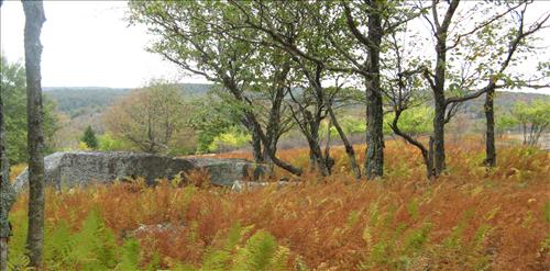
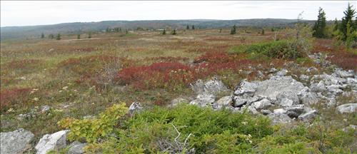
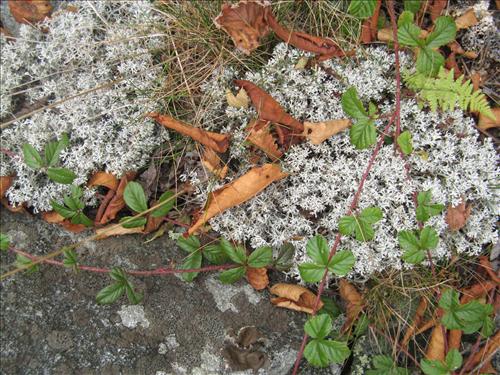
Dolly Sods, WV. After a decent sleep at camp we shaked-off some sore muscles and warmed-up on a short climb back up to TR-523. From there it was down, down, down the very long gentle slope on TR-526 into a wide and open valley. With all the adults being orienteers we could see the navigation potentials of everything we'd been through so far and this open valley continued that. Even though visibililty was very good, clumps of blueberrys, a few areas of fight, and some small contour features would be just enough to obscure some controls at boulders and rock fields. There were lots of single trees too so all of it could be challenging. We talked about having a training camp week sometime. The area would have made great rogain terrain too. Though we'd stayed on the flat lands, there were serious slopes down from the high plains--what we saw of them were really nice open woods too.
The landscape continued to be painterly. Ferns patches were either fiery orange or lime green. A sort of blueberry like low vegetation was usually red. It was usually set off against tan or white grasses. The rocks were white too and the sky this day was gray. I wished that I'd brought my better, heavier camera and had the time to play photographer like I used to do.
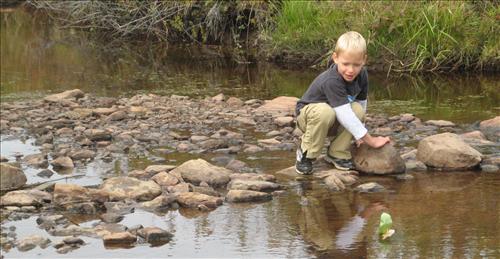
We'd made wooden boats earlier while eating breakfast. In his unfiltered self, Max voiced his concerned that my knife was't as big as Jan's. When we got to a crossing of Red Creek, he and Alexis sailed them and had fun. We had to keep making repairs. A longish walk up the valley along Red Creek on an old railroad grade brought us to TR-520. Near there was evidence of an old dam to the side of the creek.
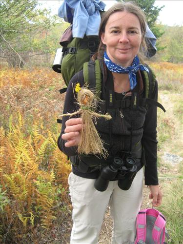
Our biggest climb of the trip was only 150ft. up to FR75. We took a break at some cool boulders. Dasa showed us what she'd been doing for much of the walk--she'd made some very nice boy and girl dolls out of grasses. The moms of the little girls from the little houses on the praries over a century ago couldn't have done better. We finished our hike walking on FR75 to get back to the TR-522 trail head and our cars. The temperature had remained in the 50's F.
It was a really nice trip and my back felt better right after the hike than it had starting out. I stiffened-up in the car again and in the evening, some sorenees in my back returned but I felt in pretty decent health.
The landscape continued to be painterly. Ferns patches were either fiery orange or lime green. A sort of blueberry like low vegetation was usually red. It was usually set off against tan or white grasses. The rocks were white too and the sky this day was gray. I wished that I'd brought my better, heavier camera and had the time to play photographer like I used to do.
We'd made wooden boats earlier while eating breakfast. In his unfiltered self, Max voiced his concerned that my knife was't as big as Jan's. When we got to a crossing of Red Creek, he and Alexis sailed them and had fun. We had to keep making repairs. A longish walk up the valley along Red Creek on an old railroad grade brought us to TR-520. Near there was evidence of an old dam to the side of the creek.
Our biggest climb of the trip was only 150ft. up to FR75. We took a break at some cool boulders. Dasa showed us what she'd been doing for much of the walk--she'd made some very nice boy and girl dolls out of grasses. The moms of the little girls from the little houses on the praries over a century ago couldn't have done better. We finished our hike walking on FR75 to get back to the TR-522 trail head and our cars. The temperature had remained in the 50's F.
It was a really nice trip and my back felt better right after the hike than it had starting out. I stiffened-up in the car again and in the evening, some sorenees in my back returned but I felt in pretty decent health.