Training Log Archive: NadimIn the 30 days ending Nov 30, 2013:
| |||||||||||||||||||||||||||||||||||||||||||||||||||||||||||||||||||||||||||||||
| « | » |
| » now | |||||||||||||||||||||||||||||||||||||||||||||||||||
| Fr | Sa | Su | Mo | Tu | We | Th | Fr | Sa | Su | Mo | Tu | We | Th | Fr | Sa | Su | Mo | Tu | We | Th | Fr | Sa | Su | Mo | Tu | We | Th | Fr | Sa | |||||||||||||||||||||||||
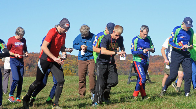
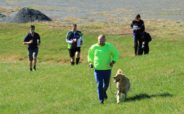
Saturday Nov 30, 2013 #
Orienteering (Foot) 2:02:33 [4] *** 8.62 mi (14:13 / mi) +475m 12:08 / mi
spiked:11/15c slept:6.0 weight:183lbs
I was somewhat confident going into this that I had a good chance to clear the course. However, it wasn't to be. I had a hard time getting into the map early-on, as well as a few times later into the 2 hours. It was in the upper 30s starting out. Initially, I had trouble getting used to distance and small variations in the terrain and the map. I lost a minute or 2 on the first control. The area was steep so even though I navigated pretty well to the second control, I felt slow and still not confident. I was feeling slowness in my legs when climbing which was probably left over from the Turkey Chase on Thursday. Looking back, the area that I started out with (#131, #132, #133, and #134) seemed the hardest with some of the more subtle contours. I felt slow enough after #2, that I headed to the road instead of a more efficient and straighter route to #3. I even had trouble reading the road when I got onto it (when returning on the same road, I didn't have trouble so it was probably just me getting confused by the map not showing the smaller bends). I had trouble estimating distance. Leaving the road, I hesitated a lot, not feeling confident of where I was but I finally did get there without much error. Going to my 4th control, I made a silly error confusing the wrong spur for the right one.
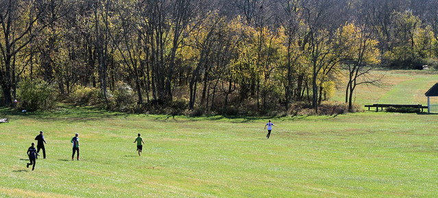
I got more on-track after this, hitting the next 8 controls (#135, #136, #137, #139, #138, #140, #142, #141) without incident. The most satisfying of these was going from #137 to #139 via the mostly frozen marsh and avoid a lot of climb. The contours on what looked to be flat land was misleading as it was much higher above the water than one might guess. After #141, I made a wishy-washy choice to go further away from the finish--I was already 70 minutes into the 2 hours when I was at a water stop. I figured I had time to get there if I didn't go for all of the controls on the south side. Thinking I was using the main road, I got confused again as far as knowing my exact location. My GPS track shows that I was really not on the main road but on a similar side road. I jumped off of the side road, hit another, and ended-up at a peninsula 500m away. I corrected this but the whole route from #141 to #143 would have been faster if had I just gone straight.
I had a half hour left when I turned back. With my map folded, it didn't dawn on me that it was at least 3k of road running with a good bit of climbing to get to the finish. I still wanted to get 4-5 off-trail controls in hilly areas too. I at first gave-up on trying to get #147 but when I ran down steep reentrants to a junction for #146, I didn't see it. I found out later that the control description for #146 was a spur and that I ran under it. Having picked-up this control after the event, I think it was hung too high up the spur from where the map showed it. The control was hung on the flat part of the spur but the center of the circle is a contour below that. While running up and down the large reentrant valleys wondering what I did, I figured that I was close to #147 so I went to it. Knowing my location, I came back for another try at #146 but still didn't see it because I hadn't read the control description.
Having lost so much time, with only 1 control to show for it, I made my way up to the road and planned to head in without attempting #148 or #149. I saw Greg Lennon and then Peggy on the road racing to get back too. I got tempted to get #149 again when I realized how close it was to the road. After passing Peggy, I ran in and spiked it, then lumbered the climbed back out almost the same way that I came in. I gained speed on the road, passing Greg and then Peggy again but I knew I was late at least 400m out. I ran pretty hard finishing up. I was glad that I only lost 2 points (1 point per control) for each 2 minutes late--I was 2:33 minutes late.
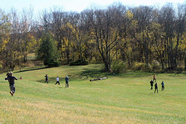
This area is pretty nice. The ground was soft. Most of the woods were white. There were some sticks on the ground but not a lot. It's definitely physical to get around in. The navigation wasn't that difficult and would get easier after being field checked. There were lots of unmapped rides on the ridges and sometimes on the sides of hills. The bottoms of reentrants were sometimes wet but often one could run up or down them. It was pretty along the water and more fun to navigate in the flatter areas.
Orienteering (Control Pickup) 32:42 [3] *** 1.59 mi (20:34 / mi) +147m 15:59 / mi
spiked:4/4c
Orienteering (Control Pickup) 14:00 [2] 0.53 mi (26:25 / mi) +34m 22:01 / mi
spiked:1/1c
Thursday Nov 28, 2013 #
Running warm up/down (Street & Trail) 13:00 [2] 1.38 mi (9:25 / mi)
slept:6.0 weight:182.5lbs
Running race (Street & Trail) 44:26 [5] 10.0 km (4:27 / km) +64m 4:18 / km
As has become habit now, Quantico Orienteering Club members came out and enjoyed camaraderie. We're all getting older and falling apart in various ways at different times. I'd had some close races with David Onkst here the last few years. I was sure he'd beat me this year but he was sidelined after a fall a couple of weeks ago and was only ready to walk/jog the course with Heidi Onkst and Darcy Good. Peggy was sidelined with aching feet--wear and tear from the Mid-Atlantic orienteering event. Kathleen Lennon and Peggy ran the 2-mile gently together. Greg Lennon came later. The Merka family ran comfortably; Jan did the 10K while Dasa and Alexis ran the 2-mile. Max and Nicole Lennon ran a different wave of the 2 mile together. I went to the starting line and quite by chance lined-up right behind Ted Good. I knew he was going to run but I hadn't seen him until I was cheering about something the announcer was saying; Ted heard my voice and turned around surprising me. A guy dressed in a banana costume suit was also standing near us.
I didn't have any expectations for the race since again I hadn't trained for it. I had been thinking over the last couple of days that I might just run it at a training pace or slowly since my back was hurting a little on the lower right side since Monday. Ted probably had a similar lack of expectations. When I asked about running it together, he indicated that it basically depended on what happened during the race with our mutual paces. That meant to me that he would be running it fairly hard. My warm-up jog to the YMCA got me brave enough to run in just shorts, a long-sleeve Quantico orienteering top, a thermal under layer top, and gloves. I figured I would try to run and see what I could do too but I really hadn't made the decision until I was in the excitement of the crowd.
The first half-mile, Ted and I paced together. We'd started at the back of the first wave where pre-race time dividers called for 7:30 minute/mile pace runners. That meant we were moving up through the crowd (~5,000 registered runners but fewer in the first wave of the starts) on the gentle uphill grade. At the first turn we headed downward. Ted opened-up and pulled ahead perhaps 20m or so. When we turned left again and headed uphill, I carried my momentum and made-up most of the distance (I think Ted's record of the mile split was between 6:36 and 6:47 and I didn't see the marker when I passed it). I didn't catch him and pass him until another half mile on another uphill grade. This seesaw sort of continued. I took it easier going down to mile 2 to conserve energy and Ted closed a gap. I saw my 2 mile split to be 13:36. Going up the long hills on Rockville Pike, other runners were either passing me or I was staying even with them. I was still looking to conserve energy and my legs were feeling the pace.
I kept expecting Ted to catch and pass me. He told me later that he almost did at the 3 mile point (I missed the split) at the top of the second largest hill on the course. However, he got a side cramp and walked a little. Ted stiffened up in the cold quickly so that even after he got going again, it was difficult for him to race. Seeing none of this, I kept going as before but slowing evermore. At 4 miles, I was 7:28, an even 7:07 pace. This was however after the main hills of the course were done and near the psychological milestone which is the point where the course turns toward the finish. One person on the sidelined called it the homestretch but in my fitness level where I'm averaging about 2 miles total a day, I couldn't call 2 miles to the finish a home stretch. My legs were getting heavy and my stride was more audible. I pushed at times as I ran on Old Georgetown Rd., but still found myself conserving energy. This was so that I could keep a steady pace to the finish and not crash. At 5 miles, I was about 35:52 and I was still saving some energy. People kept passing me, but not quickly-I kept moving close to their speed. I started feeling light-headed going into the wind, in the cold. Though I wasn't seeing with a true tunnel vision, my visual and mental focus was like that ignoring the cold running through me, the pain, the heavy breathing, and mechanically striding-on. With less half a mile left at the crest of the last uphill grade, I picked-up speed and people no longer passed me. A few of us were moving to the finish together. I accelerated more, the closer that I got to the balloon arch marking the end. At the end, I outstepped someone to the right and caught/passed the guy dressed in the banana suit that I'd seen at the start. It was a good thing that I didn't slip.
Known splits:
Mile 1 6:36 6:36
Mile 2 13:47 7:11
Mile 3 ? ?
Mile 4 28:28 14:41 (2 miles)
Mile 5 35:52 7:22
Mile 6 ? ?
10K 44:26 8:34 (greater than a mile)
I finished in 174th place overall (159th last year). I was 12/199 in my age group (last year I was 7/203 and my time from last year would have put me 6th in my age group this year). This was about 2 minutes slower than last year. My gut hurt on the right side but my back didn't bother me any more.
After the race, the QOC runners went to eat bagels together again before breaking-up for Thanksgiving festivities all around. With some of my family missing for the holiday this year, there was a sense of the loss but it was not altogether solemn.
Tuesday Nov 26, 2013 #
Bicycling (Commute) 16:00 [3] 2.8 mi (5:43 / mi)
Monday Nov 25, 2013 #
Bicycling (Commute) 16:30 2.8 mi (5:54 / mi)
slept:5.0 weight:179lbs
Bicycling (Commute) 6:15 [3] 1.41 mi (4:26 / mi)
Sunday Nov 24, 2013 #
Running warm up/down 18:10 [2] 1.69 mi (10:45 / mi) +2m 10:43 / mi
slept:7.0 weight:179.5lbs
Orienteering (Foot) 1:16:59 [4] *** 9.4 km (8:11 / km) +350m 6:54 / km
spiked:20/24c
I got off to a good start on a leg that I'd set when I last set the courses here. I learned after finishing that most people were using the left trail to climb up into the park. I used the right one, and followed a reentrant most of the way to the control. I was glad that running a little bit and sleeping better the last 2 nights helped to energize me.
I was a little sloppy going to #2. I came out a little to the left so after crossing the trail, I was on the left side of the long knoll in the middle of #1 and #2. I corrected but probably lost a little time before spiking the rest of the leg to the control.
Going to #3, I was again sloppy with my bearing. I either was having trouble getting used to wearing gloves and a headband or just running too fast. I ran straight at the control but weaved a little to find better running. Crossing the trail, I was not sure exactly where I was but I kept going anyway. The contours in the area ahead are very subtle and often confusing. I thought that I ducked under the control (to the right) a little bit before coming back higher than the control. I missed again, hitting the trail below #6. In actuality, I had missed to the left, above the control before cutting left to the trail. I turned around and finally found it. This was about a 3:30 minute error.
Going to #4 I thought to contour to save climb. This took me left more than expected. I kept in pretty good contact with the map but I lost time climbing more than needed and having to cut back to the right. Dan Do and a few others had just been to the control.
I left #4 going fairly straight and catching other runners. A 100m out, I saw the control. I briefly lost it again but basically spiked #5.
I stayed high along the ridge, rather than trying to attack straight at #6. Cutting left I closed-in on another orienteer who punched just before I did.
I headed back down toward the trail. Somehow, I got it in my head that I was heading toward #10 instead of #7. I turned right at a trail intersection and was due south of #10 before realizing what I was doing. I cut left to attack #7 from just north of due east about 400m from #7. I read my way across. Having updated the map around the area and set the control location in a past year, I navigated well and didn't lose much time--perhaps about 40 seconds.
I angled down to the trail to get to #8. At a trail bend it was hard to see the intermittent trail intersection. A guy ahead of me had passed it but when I ran up it rustling leaves, he turned to follow me. Crossing the last reentrant, I angled up the hill to the control.
I ran straight toward #9 and thought I was doing well. At one point, I thought I'd come across a point feature and adjusted my attack. I ended up left and low in the wrong set of depressions. I corrected, leading at least 2 others to the control. I probably lost about 25 seconds.
For #10, I ran up the hill but angled a bit to save climb. Ken Walker Jr. passed me going a straighter and higher way. I walked up the steep part of the hill to the knoll after crossing the reentrant but because I had a pretty good line, I wasn't far behind Ken when he got to the control.
For #11, I ran to the trail intersection as Ken was pulling away. Ken didn't use the trail much. I kept on it until near the bend where I'd jumped off when correcting my error on the way to #7. Several people were punching and I could see Ken do so before I finally got there.
Going to #12, I ran loosely. Climbing through the light green 200m before the control, I stumbled and fell. I did this a few times today but didn't get hurt (unlike poor Jon Torrance who broke his wrist somewhere on the course). Another guy was closing in on the control as I was too but he was closer and got there first.
I rushed out of #12, leaving the other guy. I ran (and walked when it got steep) left of straight, first to the set of rocks across the trail. Staying high from there, I kept a fairly straight route to #13; it was just a bit left and I ran through the only bit of green. I adjusted as I was crossing the flatish spur and past a new unmapped fallen tree/rootstock. I spiked control #13 just before I saw Ryan Stasiowski coming over from the SW, probably having used the trail.
Going to #14, I ran a bit to the left. I crossed the stream and followed a ditch over the next hill. Ryan passed me as I slowed to a walk on the climb. I went left enough to just touch the trail before contouring over the last part to the next trail. Ryan attacked ahead but I confirmed the reentrant before going in myself.
When I headed to #15, I contoured over somewhat. I could see Ryan below going a longer distance before correcting back toward #15. He still got to #15 before I did but I closed on him a bit.
Going to #16, I slowed down a bit. The cumulative climb was taking it out of me. I kept a good bearing and after crossing the trail, and when I paused, I saw that Ryan was on a bad bearing into the wrong reentrant. I also saw the control not exactly on my bearing but I went toward it anyway. Seconds later, I heard rustling leaves behind me. I got to the control just before Eddie Bergeron did.
I was a little slow eating a Gu before heading out for #17. Eddie zoomed ahead and I saw Ryan on the trail trying to figure out his position. It helped a little that Eddie was ahead to give away the control.
I took off straight and lost sight of Eddie for a while when going to #18. My bearing was true and I punched.
Some others were headed toward #19. Eddie was long gone. I noted my position when crossing the trail, and I kept a shallow reentrant to my left. From the top, I saw the shape of the hill below sticking out to the left so I used that to help spike the control.
Going to #20, I saw the spur across the reentrant. I misread the map, and expected the control to be at the end of the spur. I contoured a bit to the right to save climb but pretty soon, Eddie was coming up behind me to my left. I cut left expecting the control to be there but when neither Eddie nor I saw it, we climbed to the right contour. I probably lost about 15 seconds.
Leaving #20 to get to #21, I chased Eddie going straight and across atrail. With it mostly downhill, Eddie easily pulled ahead and was soon out of sight. I rounded a hill and dropped to the trail to use it for a while. I cut up at a bend and after cresting, I cut right more to the control.
For #22, I was a bit disappointed to be climbing again with the course nearly over, but it was a nice and tricky leg. Again, my familiarity with the park and course features helped. I got there not long after another guy had.
For #23, I contoured, going straight. I passed an older orienteer. After crossing the trail, I passed another and spiked the control.
For #24, I ran straight. Half-way there, I paused to verify the distance I'd traveled. I spiked the control, not seeing it until I rounded the rootstock.
For the finish, I ran almost straight but I did get on the trail. I was expecting the finish to be at the bottom as in years passed but hadn't read the map closely enough. I passed a small family group before bounding down. Because I wasn't expecting the finish until the bottom, I ran right past the finish. I circled back up, losing about 5-8 seconds.
Saturday Nov 23, 2013 #
Running (Trail) 26:48 [3] 3.39 mi (7:54 / mi)
slept:6.5 weight:181.5lbs
Wednesday Nov 20, 2013 #
Bicycling (Commute) 5:45 [3] 1.41 mi (4:05 / mi)
slept:4.0 weight:181.5lbs
Bicycling (Commute) 5:45 [3] 1.41 mi (4:05 / mi)
Running (Street & Trail) 12:47 [3] 1.68 mi (7:36 / mi)
Running (Street & Trail) 12:40 [3] 1.68 mi (7:32 / mi)
Tuesday Nov 19, 2013 #
Bicycling (Commute) 5:45 [3] 1.41 mi (4:05 / mi)
slept:5.0 weight:182lbs
Bicycling (Commute) 5:45 [3] 1.41 mi (4:05 / mi)
Monday Nov 18, 2013 #
Running (Street & Trail Commute) 41:50 [3] 5.28 mi (7:55 / mi)
slept:6.1 weight:183lbs
Sunday Nov 17, 2013 #
Running (Trail) 5:00 [2] 0.5 mi (10:00 / mi)
Orienteering (Foot) 1:23:59 [4] 7.4 km (11:21 / km) +230m 9:49 / km
slept:7.0
I started well. Ali Crocker was running Blue and we both ran up the same trails toward different controls in the same area. I felt much better running than I had yesterday. I spiked the control.
Going to #2 I forewent the trail route to the left over the hill that offered easier navigation. Risking going through some green terrain when I'd seen some bad woods near the start, I was happy that I could run through the green by zig-zagging only a little bit. I came upon a hunter stand but wasn't sure it was mapped. I'd been climbing or contouring most of the way so I thought I might be left of the straight route. I let myself go downhill to the right a bit and soon saw Ali Crocker again just before I got to the first trail. I paused knowing that I should know pretty well where I popped out onto the trail before leaving it, however I made a hasty decision to go on. Something in the contours was telling me that I was okay. I might not have let the compass needle settle enough. I crossed the second thinking that I had to cross a reentrant to find the control on the other side, but still much lower. At the bottom of the reentrant, I realized that I was too low. I climbed out on the other side and ran up strongly to another control. It wasn't mine. I paused a longer while and hesitantly went off to my next guess. Fortunately, that one was correct. However, I lost 2:30 minutes and used a good bit of energy. It was a good recovery for as big an error as it was. I would have liked to go back and see why I made my error.
For #3, I aimed off to the right to get to the trail, bore left, and went in from a trail bend. I was a little slow finding the control but had no real time lost.
For #4, I ran the trail and left it to climb the knoll. I was planning to go around the knoll but it seemed to have white woods that looked better than the green rocky terrain to the left. I missed seeing the trail option further down the hill on a side trail. As I went down the ridge, I though I'd counted flat spurs pretty well but I pulled-up short anyway. I even backed up a little to check out some rocks that I don't think were mapped. Eventually I went on and found it. Another guy had been leaving before I got there but I wasn't sure which rock it was.
Leaving #4, I made the mistake of not going straight down to the right. I had planned to go straight down the ridge but that was getting green. I cut left instead to use what were relatively white woods. I hit the trail at good speed but had incurred extra distance. At the stream crossing, I thought about using the lower and flat trail but I was worried that I might miss the control. The high route offered a better attack. This was however, overkill for such an easy control. The extra climb was more than I thought it'd be too. I passed a young guy whom I'd seen at #4 and punched.
I hesitated leaving #5, almost going up at first. After that I ran the trail quickly trying to put some distance on the guy whom I'd just passed. The control was easy but I guess it was just to ensure we used the bridge.
As I crossed the bridge going toward #7, I didn't look at the water level. I also started veering to the right before going back to the road. I stayed ahead of the other guy whom I'd passed earlier but got passed by another faster runner. Going uphill, I kept moving but slowed enough to get passed again. It was an easy attack to the rock but a few others were also walking up to the control.
For #8, I planned to contour across but ended up climbing a bit. The terrain was pretty rocky and made slower by not so nice vegetation. Two guys followed me for a little while. I popped out on a major trail but I wasn't sure which one. Fortunately I could see an intersection below me and that let me know I was too high. I corrected angling down to the trail that led right to #8. The guy I'd seen since #4 was just ahead of me.
For #9, I ran straight. The younger guy was ahead of me doing the same for a while but he eventually dropped low. I thought I could get ahead of him. I saw some prominent boulders so I thought I was doing okay. I crossed a leaf covered ditch and wondered why it wasn't mapped--later I figured out that this was mapped as a trail. Soon I noticed that I was too high. Just afterward, I heard noise and looked back to see Ted Good closing in on me. Bummer. I'd had about a 12 minute head start. I dropped lower then hesitated at a reentrant that looked pretty boxy above me. I concluded where I was and angled a bit upward to the next reentrant. In the process I must have gone just over the control. I went on across several reentrants but they seemed more widely spaced than I expected. That was a sign that I was too high. I crossed an intermittent trail without knowing it. Ted turned around there. I did soon after and went to the control. That was a 6 minute error. The low route was easier and I should have taken it.
For #10, I went low along the lake and ran hard up the white reentrant. A fast runner was near and I had picked up the pace. I spiked the control but it wasn't hard.
For #11, I went low again, using the first trail I hit. I followed the trail below the dam and across the stream, still ahead of the other fast runner I'd seen at #10. I crossed the creek well and spiked the control.
For #12, I crossed the creek back to the road. The faster runner had decided on this route as I was guessing at which option was better, so I followed his lead. He pulled ahead on the road. I thought he was going too low and would have a steeper climb at the end. I left the road, crossed the creek and angled up the steep slope. It wasn't bad but not real fast either. The other guy might have come around the steep slope from past the control but if that was him, he didn't gain anything on my route.
For #13, I headed to the bridge. I feared a difficult and slow creek crossing. I used trails to the east of #13, and angled up too. It was a slow slog but others were doing it too. I probably lost 30 seconds by using the bridge.
For #14, I headed to the trail bend and crossed the intersection (going over the log). The climb after leaving the trail was slow. A younger guy was on my right but I kept my own bearing and passed him. Ahead, I could see that I was closing-in on Ted Good again (he happened to be very near cramping). Ted walked slower than I did but still got to the control before I did.
For #15, I ran trying to contour over to the trail but it was taking long. I eventually cut more to the right and uphill a little. Apparently this lost me some time. Once on the trail, I eventually saw Ted Good again but knew there was no way to catch him.
For the run-in, I gave it a good push.
Overall, this was a disappointing day for me. It started when I cracked the glass of my IPad when trying to put on my spiked o-shoes. I was doing this in the car on the way to the meet on a rolling road and the IPad fell over getting under my foot. The disappointing second leg took the wind out of me and I never really recovered. I need more steady training and I hope I can start doing that now.
Saturday Nov 16, 2013 #
Running (Street & Trail) 5:00 [3] 0.5 mi (10:00 / mi)
slept:5.0 weight:181lbs
Orienteering (Foot) 1:18:15 [3] *** 7.5 km (10:26 / km) +225m 9:04 / km
spiked:11/15c
I did lose concentration twice during the race. The first was after I ran up the trail to #1, and punched it. I'd felt like I was just starting out when I headed into the woods for #2--after getting to #2, I thought the code was wrong despite the features matching. I had been looking for #101 which was the code for control #1.
Going to #3, I was lazy. Instead of going up toward the trail, I ran straight to save climb and distance. I navigated well but the forest was slower than using the trail.
I spiked #4 by trying to keep level &straight and attacking from the boulders.
I wanted to run through the valley toward #5 but I felt it'd be too green. I was worried about not having an attack point if I ran along the edge of the reentrant. I decided to compromise but I drifted down into the reentrant anyway as I was climbing it. I did a sort of S-pattern going out again and not seeing the control until I was on it due to some unmapped vegetation around it.
I ran straight at #6 and was pleased a third of the way there to come across a charcoal terrace that I hadn't seen earlier (all the map symbols were smaller than they should have been). The charcoal terrace was right on the straight path. Another third of the way there, I saw some mountain laurel which I interpreted as the mapped light green splotches that were also on the straight path. I saw the control soon after.
I debated going straight to #7 and started to do it but later reasoned that I could run the trail to the right better. The trail however, was slow with leaves hiding rocks. I left at a bend, crossing to another and turning left. I didn't see the ditch that I was looking for, to lead me in but saw some weird contours in about the right place. Going down, I soon saw the ditch, saw the stream reentrant, and spiked the control. The trail route however, was a bit on the slow side.
I took off trying to run the flat going straight to #8, and to leave a guy who'd started out of #7 about when I had. A guy was ahead of me too but I couldn't see him ahead. I spiked the control.
For #9, I ran around to the left past some vegetation that was on the straight route.
For #10, I ruled out going low for the trail route because of the green terrain I'd have to cross to get to a trail. I climbed to a higher trail, then cut across to another. I was only on that for a short while before I headed on bearing again. I tracked my progress fairly well until near the end. I got more left than I thought was correct as this took me to a control. It didn't look exactly correct but I went to it anyway because of the location of it relative to a stream. When I found out it wasn't mine, I stopped to tie my left shoe. I was a bit worried because I couldn't see another stream. When I finished with my shoe and looked up, I saw the correct control not far away, across a sort of deep and narrow reentrant.
For #11, I just kept plugging away at a steady pace to get to the top of the hill. From there it was easy to attack off of the ridge.
For #12, I started out well, going on bearing, and staying off of the ridge to my left. Before I'd gotten to #11, I'd seen Jeff Seeger seemingly closing in. I didn't know what course he was on but I thought he might be running Red. As I headed to #12 and looked to my left, I could see Jeff moving off fast. At the same time, I checked my compass bearing and it was wrong--I incorrectly concluded that I was following a wrong bearing and I turned left to follow a correct bearing that also happened to be somewhat in the direction that Jeff had run. At some low vegetation areas I couldn't tell for sure if it was the clearings marked on the map. I couldn't see any rootstocks which were mapped into the clearings so I went on. Very soon, I hit a trail. After 40 seconds or so, I relocated at a trail bend. Correcting, I went past the clearings, and then paused again because I hadn't seen the control. I soon saw the control but I'd lost about 3 minutes--worst of the day.
Going to #13, I ran straight initially. I should have cut left and used the trail that I'd relocated on earlier. I was getting confused because I was going uphill when I thought I should be going downhill--this was due to the way I'd folded my map. I hit another trail, went left to an intersection, then turned right until I saw a charcoal platform on my left. I then went on bearing but not seeing the control until I was right about on it. I was slow to read the control description (rootstock); it would have made me a few seconds quicker by letting me know that I should have run toward the green.
For #14, I was getting tired and running through the rocks made me feel it more. I knew not to go to the control to the right on the depression and soon found the boulders. I was expecting 3 but it seemed that there was only one of mappable size for this map.
For #15, I took off on a poor bearing but corrected before getting to the road. I adjusted my route to use the more open gaps that connected the different campground loops and got to the control pretty well.
Being out of shape, I didn't think running in hard would benefit me the next day so I ran an almost regular pace. I was surprised when I looked at my watch, realizing that I didn't break 10 minutes per K. Oh well.
Friday Nov 15, 2013 #
Note
slept:1.0 weight:181lbs
Wednesday Nov 13, 2013 #
Running (Street & Trail) 33:18 [3] 3.45 mi (9:39 / mi)
slept:4.0 weight:181.5lbs
Wednesday Nov 6, 2013 #
Bicycling (Commute) 5:45 [3] 1.41 mi (4:05 / mi)
slept:5.5 weight:179lbs
Bicycling (Commute) 5:45 [3] 1.41 mi (4:05 / mi)
Running (Street & Trail) 16:32 [3] 2.14 mi (7:44 / mi)
Tuesday Nov 5, 2013 #
Bicycling (Commute) 6:00 [3] 1.41 mi (4:15 / mi)
slept:4.5 weight:179lbs
Bicycling (Commute) 6:00 [3] 1.41 mi (4:15 / mi)
Monday Nov 4, 2013 #
Bicycling (Commute) 6:00 [3] 1.41 mi (4:15 / mi)
slept:5.0 weight:180lbs
Running (Street & Trail Commute) 36:35 [3] 4.4 mi (8:19 / mi)
Bicycling (Commute) 6:15 [3] 1.41 mi (4:26 / mi)
Sunday Nov 3, 2013 #
Running (Street & Trail) 3:00 [2] 0.3 mi (10:00 / mi)
slept:8.0 weight:179lbs
Orienteering race (Foot) 52:33 [4] ** 8.8 km (5:58 / km) +155m 5:29 / km
spiked:26/28c
I navigated though the first 4 loops spiking all but one control. It was virtually all in mowed fields--the one control that I hadnt spiked I'd gone to a horse jump instead of a nearby tree that seemed to have something black in it (on the map). Mentally, going into the last loop, I was just expecting it to be 2.5k. It was 4.5k so I started thinking about pacing. I didn't see anyone nearby when I was going to #1 and I relaxed a bit without thinking I was slowing much. Leaving #2, I started hearing footsteps. Howie Weinstein seemed to be catching up but I held him off, climbing to #6 before he disappeared behind me. I'd gone around a short way to use a road and just before reaching #6, Dave Pruden came through the woods a few steps behind me. I guess the pace and the added worry of Dave coming suddenly out of nowhere had shook me at the wrong time. I left #6 with a bad bearing and I was partly confused by some thin buildings that on the map looked like a trail intersection. I noticed Dave peel off to the right but figured I'd be okay going my way getting to the road instead of using the shorter but potentially slower field. When I dropped over to the road however, I still wasn't watching my compass as I'd done all the way up to this point. I hit the road at an intersection and turned down the wrong direction. It also happened to be an out of bounds area so with it obscured by striping on the map, it took me a few seconds more to figure out what I'd done. I backed out and got back on course but the damage was done. Dave was well ahead, I glimpsed him a few more times but I didn't seem to make up much ground. Other than the mistake at #6, I was happy that I ran pretty well and pushed throughout the race. It was similar to a cross country race.


Saturday Nov 2, 2013 #
Running (Street & Trail) 1:05:17 7.06 mi (9:15 / mi) +112m 8:49 / mi
slept:7.5 weight:182lbs
Orienteering (Field Checking) 1:40:00 [1] 1.5 mi (1:06:40 / mi)