Training Log Archive: nmulderIn the 7 days ending Jul 8, 2012:
| ||||||||||||||||||||||||||||||||||||||||
| « | » |
| » now | ||||||||||
| Mo | Tu | We | Th | Fr | Sa | Su | |||||||
Sunday Jul 8, 2012 #
Note
JWOC Sprint Final took place today in Kosice. Best runs were from Brad and Steph. Brad produced a new PB for South Africa, placing 74th. At one stage he was 52nd. He came awfully close to a top 60, just 5 secs short!
Steph came just short of a new SA personal best, finishing 73rd. Likewise, she was running in 29th spot as late as 2/3rd of the way through the course before making a 30s mistake.
Good and fair results all-round though. Courses were easy, which didn't exactly suite our runners.
Steph came just short of a new SA personal best, finishing 73rd. Likewise, she was running in 29th spot as late as 2/3rd of the way through the course before making a 30s mistake.
Good and fair results all-round though. Courses were easy, which didn't exactly suite our runners.
Saturday Jul 7, 2012 #
Event: JWOC 2012 Kosice SLOVAKIA
9 AM
Note
Walked around the model areas for the Long Distance (Soroska) and the Sprint (Park Angelinum).
 |
| From Orienteering Maps |
 |
| From Orienteering Maps |
Friday Jul 6, 2012 #
11 AM
Orienteering (Zeleny Dvor) 34:30 [2] 2.5 km (13:48 / km)
shoes: Inov-8 Oroc 280 #2
Last training session. Middle distance terrain / control picking.
And an area we didn't use for training...
 |
| From Orienteering Maps |
And an area we didn't use for training...
 |
| From Orienteering Maps |
Thursday Jul 5, 2012 #
11 AM
Orienteering (Baziny) 50:00 [2] 4.5 km (11:07 / km)
shoes: Inov-8 Oroc 280 #2

Wednesday Jul 4, 2012 #
10 AM
Orienteering (Dievcenska skala) 1:29:06 [2] 6.0 km (14:51 / km)
shoes: Inov-8 Oroc 280 #2
Back to long distance terrain. Very nice map again, by Robert Micek, even though it's a few years old. Looking forward to seeing his JWOC maps.
Shadowed Ant for most of the way. Mix of forest and open bush terrain.
Temperatures abated a little bit today. Only just touched the 30's by 10am. Went for a drive afterwards and got caught in a spectacular hailstorm.
Shadowed Ant for most of the way. Mix of forest and open bush terrain.
Temperatures abated a little bit today. Only just touched the 30's by 10am. Went for a drive afterwards and got caught in a spectacular hailstorm.
 |
| From Orienteering Maps |
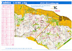
Tuesday Jul 3, 2012 #
9 AM
Orienteering (Zeleny Dvor) 1:24:00 [3] 4.0 km (21:00 / km)
shoes: Inov-8 Oroc 280 #2
Middle distance map. A really beautiful area that has been very well mapped by the same mapper who's produced a lot of the JWOC maps. Everyone thoroughly enjoyed this training, which went through complex contour terrain in very white forest.
 |
| From Orienteering Maps |
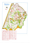
3 PM
Orienteering (Bankov) 1:04:11 [3] 4.3 km (14:56 / km)
shoes: Inov-8 Oroc 280 #2
Another relay training, but only for the late arrivals, as we'd been on this map before. Shadowed Jess the whole way.
 |
| From Orienteering Maps |
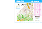
Monday Jul 2, 2012 #
10 AM
Orienteering (Torzo) 1:30:00 [2] 6.0 km (15:00 / km)
shoes: Inov-8 Oroc 280 #2
First run in Long distance terrain, typical Hungarian-type Karst with lots of large sink-holes, but otherwise nice white forest.
 |
| From Orienteering Maps |
3 PM
Orienteering (Jastericie jazero) 1:30:00 [2] 6.0 km (15:00 / km)
shoes: Inov-8 Oroc 280 #2
Long distance training that focused on route choices in the open, scattered bush terrain that will form part of the Long map. Fun area, but incredibly hot. Thermometers indicated 35.5'C on the way home at 5pm!
 |
| From Orienteering Maps |