Training Log Archive: TheInvisibleLogIn the 7 days ending Jun 4, 2023:
| |||||||||||||||||||||||||||||||||||||||||||||||||||||
| « | » |
| » now | ||||||||||
| Mo | Tu | We | Th | Fr | Sa | Su | |||||||
Sunday Jun 4, 2023 #
Running 37:57 [3] 5.32 km (7:08 / km) +45m 6:51 / km
shoes: Speedcross 16th pair
Saturday Jun 3, 2023 #
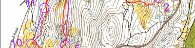
Running 1:11:26 [3] 5.19 km (13:46 / km) +280m 10:50 / km
shoes: Speedcross 16th pair
Close to mistake free run*. Slightly low on 6. Winsplits claims I also made an error on 2, but this was just me be highly cautious on the slippery bare rock which lay between 1 and 2.
* In 2023 the word "run" does not imply running at all times. It may not imply running at all.
* In 2023 the word "run" does not imply running at all times. It may not imply running at all.
Walking 30:00 [2] 1.5 km (20:00 / km) +70m 16:13 / km
shoes: Speedcross 16th pair
Control collection
Friday Jun 2, 2023 #
Walking 2:30:00 [1] 10.0 km (15:00 / km)
Thursday Jun 1, 2023 #
Walking 1:50:00 [3] 3.0 km (36:40 / km) +83m 32:13 / km
The search for new terrain isn't all beer and skittles. The plan today was to check out a potential short bushwalk up one of the unfrequented peaks around Inglewood, and to scope out the adjoining forest - Kingower Ridge between Kingower and Inglewood. From the south on the road to Kooyoora the peak looks open and prone to lovely views. But some research revealed the approach from that side is through private land. So we decided to approach from the north, walk to the east end of the ridge and then along the ridge to its highest point. The expectation was that it might be a bit thick on the uphill, but the ridge top would be fine. Well, it wasn't. The first kilometre toook 40 minutes with no breaks. By then we were on top of the ridge. We traversed two subsidiary high points expecting the green to clear any moment. But on the descent into the saddle before the next high point the scrub became almost impenetrable. I think we were much slower than 1 hour per kilometre. Garmin Connect doesn't recognise progress that slow. So the decision was made to bail out. We used the Google Maps satellite image to find the best route down the mountain, but getting to the top of that exit route entailed more scrub bashing. We were glad to escape. Will try and find another way up. For now let's just say we ascended Kingower Ridge East Peak. Oh, and the photos are in the "open" areas.
After a recuperating lunch at the Inglewood bakery, we drove up to the top of the Bald Hills and sat in chairs to admire the view gained without a moment of scrub.
Early on the climb, full of hope.

Still hopeful, but less so.

Get me out of here. This is one of the open leads we found to get off the hill.
That is Korong on the horizon.

After a recuperating lunch at the Inglewood bakery, we drove up to the top of the Bald Hills and sat in chairs to admire the view gained without a moment of scrub.
Early on the climb, full of hope.
Still hopeful, but less so.
Get me out of here. This is one of the open leads we found to get off the hill.
That is Korong on the horizon.
Tuesday May 30, 2023 #
Walking 2:00:00 [1] 8.0 km (15:00 / km)
Really ruined a walk. Really really ruined.
Monday May 29, 2023 #
Walking 2:30:00 [1] 10.0 km (15:00 / km) +200m 13:38 / km
shoes: Speedcross 16th pair
Checking out and then discounting a potential terrain for Easter 2025. If it was near Bendigo it would be fine to map for a local series. But being 1hr NW of Bendigo, and being just average quality, its not a good investment of either time or money.