Discussion: Daze 4
in: Laramie Daze (Aug 1–6, 2014 - Laramie, WY, US)
Jun 20, 2014 6:24 PM
#
Laramie Daze 4 will take place at the never before used Brown's Landing area using a brand new map completed this spring. It will feature big views and an area with a very different sort of "feel" from the other areas used this year. Some of the controls will demand more careful map reading than is usual for Daze. There is one man-made control feature which was constructed especially for this event. Unusually for Laramie Daze, there will be a walk to the start--up, up, up, and up! Not unusually for Laramie Daze, the race will use a proper mass start. The longer course is 5.9 km with a shorter 4.7 km version available. There may be moose (there was one yesterday), there may be cows, and there will definitely be thin air, as this is one of the very highest O' venues in the US!
The guy at the bike shop the other day told me to: "Ride hard and take chances!" I will not advise anyone to take chances at Daze 4, but running hard is always a good idea. ; )
More details are at the website
The guy at the bike shop the other day told me to: "Ride hard and take chances!" I will not advise anyone to take chances at Daze 4, but running hard is always a good idea. ; )
More details are at the website
Jun 21, 2014 4:34 AM
#
Here is a picture of a man-made object.
Though it's not one I made.
Actually, it's not even on the map, but it is nearby.
I believe it is a container of super explosive fuel for ICBM missiles, though it's hard to be sure.
Though it's not one I made.
Actually, it's not even on the map, but it is nearby.
I believe it is a container of super explosive fuel for ICBM missiles, though it's hard to be sure.
 |
| From publiken |
Jun 21, 2014 8:33 PM
#
Here is another picture of a man-made object.
But once again, it's not one I made.
However, this man made object *is* on the map, though it's not marked on the map. Is it what I think it is, or it--a--just--a--confusion?
But once again, it's not one I made.
However, this man made object *is* on the map, though it's not marked on the map. Is it what I think it is, or it--a--just--a--confusion?
 |
| From publiken |
Jun 23, 2014 5:40 AM
#
It's pretty well known that ISOM are in the process of being updated right now. It's less well known that an effort is also underway to revise ISCD (International Specification for Control Descriptions) in large part because the existing specification is almost entirely inadequate in terms of being able to meet the exacting demands of modern Trail Orienteering (which its adherents more popularly refer to as "the sport that doesn't use whistles.")
So, we have set aside Daze 4 this year as the race where some of the new proposed symbols and modifiers will greet the light of day, with hopes of soliciting useful comment and feedback from the competitors. The following should give you some taste of what will be coming. Some of the views you are about to see are actual views runners may experience during the Daze 4 race, and you should not attempt to adjust your web browser (unless it is Windows Explorer.)
Many people will react to the picture below by exclaiming: "Ah, a root stock control, excellent!" Actually, there is nothing excellent about root stock controls. At least 98% of them (at least on US maps) are sheer rubbish and should never have been mapped in the first place. And this isn't a root stock control anyway. The chances of a root stock control ever being used at Laramie Daze are exactly zero.
So what it this, if not a root stock control? This control shows the use of the new "bag in the forest" symbol, which is represented by a control icon in column 4 of control descriptions, and is the result of fierce lobbying of the IOF for same by JJ Cote', whose personal motto is: "When you see a culvert, crawl through it, rapidly."
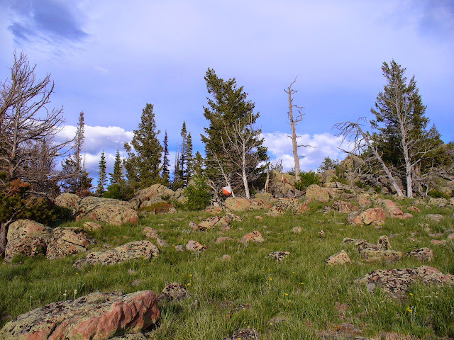
Some people are also probably wondering if that's what all the forest looks like at Brown's Landing. No. That's just what beetle killed parts of the forest look like after being shaken and stirred by those friendly Wyoming breezes.
*****
Many people will now think they are ready to grasp that the next control is also "bag in the forest":
Unfortunately, they are wrong. The control feature here is "distinct tree" and since it is so tiny, it gets the column 5 modifier "soooo tiny" written in 1 point type. The new ISCD will add a column 9 for additional useful information, and this control is a prime example of how the new column will come into play. In this case, the letter "Y" will be shown in column 9, indicating "area of yellow flowers." See how much better that is? You just run around, look for yellow flowers, and then identify the distinct tree. Couldn't be easier!
*****
This next shot gives a good idea of what much of the tougher footing portions of the interior of Brown's Landing look like.
Control #1 should be in plain sight, but for the life of me I can't see it, even though I know where to look. So I doubt you can see it either:
Once some years ago I was running down the trail in the photo; dusk was not far off but the day remained still warm with late afternoon sun, and right where the trail goes into the trees, I was surprised to come across a couple in the act of disrobing. I couldn't be sure what was going on, but the girl was singing: "Why Don't We Do it in the Road?"
About the last thing in the world I was expecting to experience while running through Brown's Landing that day was someone singing a 12 bar blues song by the Beatles. True story.
*****
This next shot shows the control "the boulder". But it's hard to tell on the map just which boulder.
And that's why in column 3 the new "one of many" modifier is used--a bunch of random lines with a black dot on one of them. Additionally, the "thumbs down" icon will appear in column 5, which means the feature in question should never have been mapped in the first place.
*****
This next control may look like "the cliff", but actually it's "the snowfield, top of" The snowfield is shown by a snowflake icon in column 4, and "top of" is shown in the usual way. But here column 9 comes into play again, with a "skull and crossbones" icon appearing, showing this is a very bad place to slip and fall down the perilous snow field.
*****
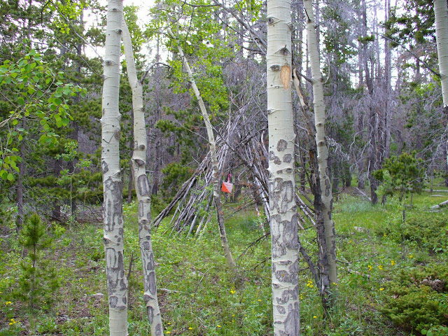
Whoa! What's this! It's an actual man-made object that I made and which is also on the map! And it's not just any old man-made object--it's a tipi. Tipis may not be very common in Venice, but out here in the Rocky Mountains, they're everywhere.
Admittedly, this isn't one of the better tipis you'll ever see, and in fact it may be one of the worst. But it has a control inside it, and that's what makes it magical. And that's also why runners will be looking very intently for this particular tipi during Daze 4. Give it an "X" in column 4 to show it's a man-made feature, the word "tipi" in one point type in column 5, and the new modifier to show "inside" is portrayed by a box with a dot inside it, in column 7.
*****
This is one of 12 knolls used for the Daze 4 course. Knolls are easy to pick out on the map at Brown's Landing because of their size, and that made them good control features, too. Hard to accidentally hang a control on a boulder or a diffuse pit when what you had really intended to do is to put it at the top of one of the giant knolls.
This is one of the smaller knolls at Brown's Landing, and that's why this control feature got the "low" appearance modifier in column 5.
There is a control up there, by the way. Look hard. You'll find it.
Some people think that skymning only happens in Sweden, but this photo is proof that skymning also occurs in the Laramie Range. At least it does in sommartid.
If you don't know Swedish but can correctly pronounce "skymning" anyway, then give yourself a gold star!
*****
This next photo is also the last photo (sorry, Brooke, but all good things must end eventually), and shows "the nose". However, since the control is placed in a very ambiguous location somewhere on the nose, the "ambiguous" modifier--a question mark, in column 7--is deployed. And to add an extra degree of emphasis that the course setter has absolutely no idea where on the nose the control is, or even if it's a "nose" at all, the "ambiguous" modifier is also inserted into column 9.
This photo also makes clear that despite the fact you, the racer, have come so far to reach this point, you still have to somehow get down the hill, and you don't have all day to do it, because the effin (that's technical language we won't get into here) course closes at effin (again, not the time or place) 12:00!!! Run to the control, punch and move on, or stop and smell the sage and take in the view--choices, choices...well, we all have to make our own choices, don't we?
The craggy peaks at right background are Vedauwoo, which is where climbers go to defoliate their hands, and where orienteers go to camp when they don't know they should go to Yellow Pine instead.
So, we have set aside Daze 4 this year as the race where some of the new proposed symbols and modifiers will greet the light of day, with hopes of soliciting useful comment and feedback from the competitors. The following should give you some taste of what will be coming. Some of the views you are about to see are actual views runners may experience during the Daze 4 race, and you should not attempt to adjust your web browser (unless it is Windows Explorer.)
Many people will react to the picture below by exclaiming: "Ah, a root stock control, excellent!" Actually, there is nothing excellent about root stock controls. At least 98% of them (at least on US maps) are sheer rubbish and should never have been mapped in the first place. And this isn't a root stock control anyway. The chances of a root stock control ever being used at Laramie Daze are exactly zero.
So what it this, if not a root stock control? This control shows the use of the new "bag in the forest" symbol, which is represented by a control icon in column 4 of control descriptions, and is the result of fierce lobbying of the IOF for same by JJ Cote', whose personal motto is: "When you see a culvert, crawl through it, rapidly."
 |
| From publiken |
Some people are also probably wondering if that's what all the forest looks like at Brown's Landing. No. That's just what beetle killed parts of the forest look like after being shaken and stirred by those friendly Wyoming breezes.
*****
Many people will now think they are ready to grasp that the next control is also "bag in the forest":
 |
| From publiken |
Unfortunately, they are wrong. The control feature here is "distinct tree" and since it is so tiny, it gets the column 5 modifier "soooo tiny" written in 1 point type. The new ISCD will add a column 9 for additional useful information, and this control is a prime example of how the new column will come into play. In this case, the letter "Y" will be shown in column 9, indicating "area of yellow flowers." See how much better that is? You just run around, look for yellow flowers, and then identify the distinct tree. Couldn't be easier!
*****
This next shot gives a good idea of what much of the tougher footing portions of the interior of Brown's Landing look like.
Control #1 should be in plain sight, but for the life of me I can't see it, even though I know where to look. So I doubt you can see it either:
 |
| From publiken |
Once some years ago I was running down the trail in the photo; dusk was not far off but the day remained still warm with late afternoon sun, and right where the trail goes into the trees, I was surprised to come across a couple in the act of disrobing. I couldn't be sure what was going on, but the girl was singing: "Why Don't We Do it in the Road?"
About the last thing in the world I was expecting to experience while running through Brown's Landing that day was someone singing a 12 bar blues song by the Beatles. True story.
*****
This next shot shows the control "the boulder". But it's hard to tell on the map just which boulder.
 |
| From publiken |
And that's why in column 3 the new "one of many" modifier is used--a bunch of random lines with a black dot on one of them. Additionally, the "thumbs down" icon will appear in column 5, which means the feature in question should never have been mapped in the first place.
*****
This next control may look like "the cliff", but actually it's "the snowfield, top of" The snowfield is shown by a snowflake icon in column 4, and "top of" is shown in the usual way. But here column 9 comes into play again, with a "skull and crossbones" icon appearing, showing this is a very bad place to slip and fall down the perilous snow field.
 |
| From publiken |
*****
Whoa! What's this! It's an actual man-made object that I made and which is also on the map! And it's not just any old man-made object--it's a tipi. Tipis may not be very common in Venice, but out here in the Rocky Mountains, they're everywhere.
 |
| From publiken |
Admittedly, this isn't one of the better tipis you'll ever see, and in fact it may be one of the worst. But it has a control inside it, and that's what makes it magical. And that's also why runners will be looking very intently for this particular tipi during Daze 4. Give it an "X" in column 4 to show it's a man-made feature, the word "tipi" in one point type in column 5, and the new modifier to show "inside" is portrayed by a box with a dot inside it, in column 7.
*****
This is one of 12 knolls used for the Daze 4 course. Knolls are easy to pick out on the map at Brown's Landing because of their size, and that made them good control features, too. Hard to accidentally hang a control on a boulder or a diffuse pit when what you had really intended to do is to put it at the top of one of the giant knolls.
This is one of the smaller knolls at Brown's Landing, and that's why this control feature got the "low" appearance modifier in column 5.
There is a control up there, by the way. Look hard. You'll find it.
 |
| From publiken |
Some people think that skymning only happens in Sweden, but this photo is proof that skymning also occurs in the Laramie Range. At least it does in sommartid.
If you don't know Swedish but can correctly pronounce "skymning" anyway, then give yourself a gold star!
*****
This next photo is also the last photo (sorry, Brooke, but all good things must end eventually), and shows "the nose". However, since the control is placed in a very ambiguous location somewhere on the nose, the "ambiguous" modifier--a question mark, in column 7--is deployed. And to add an extra degree of emphasis that the course setter has absolutely no idea where on the nose the control is, or even if it's a "nose" at all, the "ambiguous" modifier is also inserted into column 9.
This photo also makes clear that despite the fact you, the racer, have come so far to reach this point, you still have to somehow get down the hill, and you don't have all day to do it, because the effin (that's technical language we won't get into here) course closes at effin (again, not the time or place) 12:00!!! Run to the control, punch and move on, or stop and smell the sage and take in the view--choices, choices...well, we all have to make our own choices, don't we?
 |
| From publiken |
The craggy peaks at right background are Vedauwoo, which is where climbers go to defoliate their hands, and where orienteers go to camp when they don't know they should go to Yellow Pine instead.
Jun 23, 2014 1:12 PM
#
feet:
Awesome. I think these might be the first event announcements to be read so avidly even by those who will be thousands of miles away at event time.
Jul 1, 2014 6:32 PM
#
I have added some additional information about the walk to start (how much time to allow), at the event web site.
Also, inspection of the snowfield at dusk revealed it has all melted away. I am still trying to figure out what to do. White confetti spread on the ground? A sign saying "Snowfield was here, but now it's gone"? Maybe get a volunteer to dress up as a scary snowman who will be instructed to frighten and scare off all racers who attempt to punch at the control at the now non-existent snowfield? The decisions you have to make as a race organizer!
Also, inspection of the snowfield at dusk revealed it has all melted away. I am still trying to figure out what to do. White confetti spread on the ground? A sign saying "Snowfield was here, but now it's gone"? Maybe get a volunteer to dress up as a scary snowman who will be instructed to frighten and scare off all racers who attempt to punch at the control at the now non-existent snowfield? The decisions you have to make as a race organizer!
Jul 17, 2014 11:20 PM
#
Formal test running of the Daze 4 course was completed earlier today. We are pleased to be able to announce that this course has achieved certification as 5 Spurs

by the International Cowboy Orienteering Association (ICOA). This is the highest level of certification that is awarded, and indicates a quality level that many aspire to but few achieve. Happily no rain interposed today and even more happily not a single mosquito was sighted. It was just butterflies, flowers, and pink snitsel from start to finish. Plus maybe a stray piece or two of granite here and there.
Our calculated winning time for the 5.8 km, 17 control course is 44:23, but that time will be dependent on whether or not the best racer on the day pauses to take in the magnificent (truly) view at the #13 control. The course also features several controls that most racers will find to be unlike any they have ever seen before, and is as well the course that has the greatest percentage of time spent in forest running. There is some high altitude, short grass prairie, but it will come and go quickly!
Test running will continue on Saturday with the Daze 5 course, and will conclude on Sunday with testing the One Cowboy Relay.
Aug 4, 2014 10:59 PM
#
Daze 4 began with a mandatory pre-race warm-up. That is, a vigorous walk up one of the more notorious Happy Jack trails--the Headquarters Trail. The race used the eastern approach, as one more suited to this particular event as the walk up would be illuminated by the early rising sun. Once the hordes were assembled at the Start, it was time for the traditional race briefing, but, alas, all came to a crashing halt when the briefer was forced to admit that he had forgotten where the secret cut-off for the short course would be. And it wasn't printed on the map. Not good.
So the briefer did what he could, which was to attempt to bluff his way through it, and do his best to authoritatively assert where the secret cut-off would (incorrectly) occur. Fortunately, an attentive and better briefed racer was able to speak up, and mildly suggest what the actual (correct) secret cut-off would be, and from there the briefing was able to move forward again towards the desired end result: the start signal!
A reminder of how we are all at best merely mortal, and that many of us (briefers) are besides that, flawed.
Results, Daze 4: Conditions lightly overcast, pleasant temps, no mosquitoes, no cattle, usual Brown's Landing amounts of ground juniper and broken granite residues.
Short
Sam Kelsch 57.23 S
Ioana Lindsey 58.04 S
AJ Riley 64.22 S
Peter Zakrevski 64.23 S
Paul Clatterbuck 64.24 S
Alex Yancey 68.51 S
Brennan Hertel 68.55 S
Brooke Mann 69.23 S
Bob Ellis 76.47 S
Sam Bali 78.01 S
Jamie Reeder 78.45 S
Hayden Morse 83.01
Valentina 84.01 S
George Walker 90.01 S
Nicole Lennon 91.49 S
Oriana Riley 91.51 S
Mike Shifman 99.41 S
Sheryl Lehman 115.01 S
Steve Levin 115.01 S
Shelagh Pepper 116.01 S
Anndy Wiselogle 117.01 S
George Wood 119.01 S
Shirley Donald 139.01 S
Carl Moore 146.01 S
Linda Moore 146.01 S
Long
Wyatt Riley 50.34
Ondrej Jezek 52.18
JP Lande 53.58
Mikhail Martemyanov 54.15
Troy Bozarth 54.41
Theodore Good 67.07
Charlie Shahbazian 68.41
Tom Svobodny 69.24
Steve Gregg 69.58
Clinton Morse 70.05
Ron Birks 70.21
Nadim Ahmed 71.41
Angelica Riley 72.01
Bill Langton 73.41
Peter Golde 74.42
Robert Minto 74.57
Ben Langton 75.01
Rich Kelly 75.05
Peggy Dickison 75.14
Leonid Shatskin 75.17
Greg Lennon 76.41
Sam Listwak 77.31
Michael Minium 78.37
Craig Weber 78.43
Kris Beecroft 79.01
Stina Bridgeman 80.07
Eric Rosenzweig 80.11
Quincy Rosenzweig 80.11
Sue Kuestner 80.54
Gavin Wyatt-Mair 80.54
Steve Houghton 83.01
Brendan White 83.01
Mark Parsons 84.41
Thomas Laraia 88.54
Ken Lotze 89.47
Steve Dornseif 90.01
Carol Johnson 90.33
Kathleen Lennon 91.51
Peter Goodwin 93.01
Lyn Walker 98.01
Guy Olsen 98.13
Donna Fluegel 136.01

This discussion thread is closed.