Discussion: Alternative to StringO!?
in: Orienteering; General
Sep 5, 2013 2:47 PM
#
On August 20, 1920, the United States opened its first coast-to-coast airmail delivery route, just 60 years after the Pony Express closed up shop.
There were no good aviation charts in those days, so pilots had to eyeball their way across the country using landmarks. This meant that flying in bad weather was difficult, and night flying was just about impossible.
The Postal Service solved the problem with the world’s first ground-based civilian navigation system: a series of lit beacons that would extend from New York to San Francisco. Every ten miles, pilots would pass a bright yellow concrete arrow. Each arrow would be surmounted by a 51-foot steel tower and lit by a million-candlepower rotating beacon. A generator shed at the tail of each arrow powered the beacon.
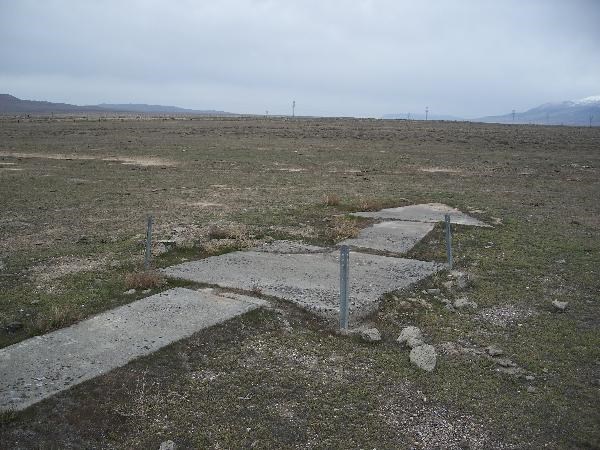
More pictures: The yellow arrow road
There were no good aviation charts in those days, so pilots had to eyeball their way across the country using landmarks. This meant that flying in bad weather was difficult, and night flying was just about impossible.
The Postal Service solved the problem with the world’s first ground-based civilian navigation system: a series of lit beacons that would extend from New York to San Francisco. Every ten miles, pilots would pass a bright yellow concrete arrow. Each arrow would be surmounted by a 51-foot steel tower and lit by a million-candlepower rotating beacon. A generator shed at the tail of each arrow powered the beacon.
More pictures: The yellow arrow road
Sep 5, 2013 3:10 PM
#
Heh, who knew? Not heard of this before.
I wonder how many of the arrows are left?
So...we produce of map of where the arrows are/were across the country, print a bunch of maps, hand them out at midnight in NewYork city, first one to SF (On foot of course) with all the controls is the winner.
The ultimate TRAVERSE!
I wonder how many of the arrows are left?
So...we produce of map of where the arrows are/were across the country, print a bunch of maps, hand them out at midnight in NewYork city, first one to SF (On foot of course) with all the controls is the winner.
The ultimate TRAVERSE!
Sep 5, 2013 3:25 PM
#
In the town where I grew up there was a hill called "Beacon Hill" and the story was there was a beacon up there that planes would use for navigation---though it would not have been on the optimal route from NYC to SF
Sep 6, 2013 12:50 PM
#
These were at the time leading edge crumbs; so post H&G.
But seriously, wouldn't directional arrows be a learning experience for kids. A blinking LED on the arrow would add coolness. Setting-up/retrieving would be faster but more of a challenge.
But seriously, wouldn't directional arrows be a learning experience for kids. A blinking LED on the arrow would add coolness. Setting-up/retrieving would be faster but more of a challenge.
Sep 6, 2013 1:16 PM
#
They use sad faces on the kids courses in Sweden to show when one has gone down the wrong way. Allows a harder course design while still providing a close perimeter so no one goes badly off course.
Sep 7, 2013 1:34 AM
#
Sounds good. Do they use super-white courses (trails only) with wrong turn trails marked with the sad faces?
Sep 8, 2013 5:23 AM
#
bubo:
The easiest kids course (Inskolning) is super-white - trails only most of the time. Happy faces spread out along the correct route, sad faces a little ways into a wrong choice. No signs AT the intersections, but reassuring later if the choice was right and correcting if someone has made a wrong turn.
This discussion thread is closed.