Discussion: the best North American urban city orienteering venue
in: Orienteering; General
Aug 8, 2013 3:29 PM
#
Not where I live. Although the bunker hill area of Downtown LA has some promise, it's still far from best in NA I would think.
Aug 8, 2013 4:01 PM
#
North End, Boston https://maps.google.com/maps?q=north+end+boston+ma...
But the map isn't done, and actually getting permission to ever run a real meet on it would be difficult. Lots of cars and people, but also lots of little alleys and small parks.
But the map isn't done, and actually getting permission to ever run a real meet on it would be difficult. Lots of cars and people, but also lots of little alleys and small parks.
Aug 8, 2013 4:09 PM
#
Are there any places with no cars?
There are probably some college campuses that are car-free.
When I was scouting the downtown area of Wichita last week, I felt that it had some pretty good sprint potential. The sidewalks and bridges along/over the rivers aren't constrained by vehicular traffic and they make for good route choice problems, and there are some detailed pockets of 1960's and 70's-era concrete plazas and fountains and such, and several wooded parks. I'm not nominating Wichita as tops in North America, but it's surprising where you can find some nice sprint terrain. It's up there for the best sprint terrain in Kansas.
Seattle may have some potential for some really cool stuff, say in 2017. There's going to be the big waterfront park development which may connect a whole bunch of stuff, and they keep talking about updating Seattle Center.
Aug 8, 2013 4:14 PM
#
Seems like Vancouver and Ottawa would be the frontrunners right now, in terms what is already mapped. Some of Vancouver's map usage is pretty ingenious. A detailed downtown map where there are cars? Let's set up interval training where you zoom around some fun, detailed stuff, and then end at a crosswalk. Cross the street and repeat.
Aug 8, 2013 4:34 PM
#
We do have some good universities for sprints, such as UBC, SFU and Carleton. Also, to answer the original question, the first place to come to mind is Whistler.
Aug 8, 2013 5:14 PM
#
I bet Quebec City would be pretty interesting in the "old city" section.
Aug 8, 2013 6:23 PM
#
AZ:
Seems to me there is no issue here at all. The answer is Whistler Village.
No cars. Lots of twisty streets. Lots of "secret" passage ways. Nice difference in levels. Glorious scenery and start/finish in Olympic Plaza. Seriously, nothing comes close in my experience.
Here's the Route Gadget from 2010 Western Canadian champs.
And - in exactly one year from last weekend you can check it out for yourself. 2014 Canadian Champs in Whistler, including (probably a WRE) sprint in the Village.
Aug 8, 2013 6:24 PM
#
AZ:
@blegg - not really a degree granting college, more a college of life-style experiences ;-) Closest college is Quest in Squamish, or UBC in Vancouver.
Aug 8, 2013 6:45 PM
#
Mt Tremblant, Quebec?
Hudson, Quebec?
Epcot Center?
Queen's University, Kingston ON
Hudson, Quebec?
Epcot Center?
Queen's University, Kingston ON
Aug 8, 2013 8:01 PM
#
Ahh, thanks for the clarification, AZ ;-) Hopefully the younger folks will take advantage. I'm afraid I wasn't such a good student back in the day. I did go to the local institution, but thanks to a broken leg, I never really finished my (mount) Bachelor degree. I keep meaning to continue my studies at Tahoe... but life gets in the way.
Aug 8, 2013 8:39 PM
#
Oh, was that a serious question, blegg? Maybe my reaction shouldn't have been so snarky...
Aug 8, 2013 10:17 PM
#
I still think that a sprint race in Vail would look mighty good here. Unfortunately, Glen pitched orienteering to the event organizers but they weren't interested in adding us.
Aug 8, 2013 11:19 PM
#
Not really a serious question Carol. After 13 years of higher education, I'm ready to be done. But I have to admit, when AZ mentioned that there was a university in Squamish, I did check to see if they had any job openings.... (I've already got TMCC listed on my job-search agent)
Aug 8, 2013 11:58 PM
#
Aug 9, 2013 12:13 AM
#
I was thinking about what US cities would have lots of twisty streets. Aside from planned subdivisions in hilly areas, I would think they would mostly be the oldest cities established. Boston, as mentioned previously. A lot of others I looked at were laid out in grids. Then I put aside my Anglo-centrism and thought of Santa Fe, NM. I've never been there, though, so I don't know about traffic or other considerations.
Going back even further, how about San Juan, Puerto Rico? That counts as North America.
Going back even further, how about San Juan, Puerto Rico? That counts as North America.
Aug 9, 2013 3:31 AM
#
Yes, you should move here! And my sister went to Quest, just in case a job opening appears and you want some insider information.
Aug 9, 2013 4:29 AM
#
Some more city ideas:
1. I looked at New Orleans... blockier than I thought it would be!
2. Portland, Maine?
3. Charleston, South Carolina?
4. Pittsburgh... you can cross 3 rivers.
Pittsburgh is the only one I've been to. What about the others?
1. I looked at New Orleans... blockier than I thought it would be!
2. Portland, Maine?
3. Charleston, South Carolina?
4. Pittsburgh... you can cross 3 rivers.
Pittsburgh is the only one I've been to. What about the others?
Aug 9, 2013 3:10 PM
#
There is a sprint event happening on the University of Ottawa's campus in September. I've only seen a small part of it so far so I don't know how good an area it'll be.
Aug 9, 2013 5:25 PM
#
Hey Becky. I am indeed, just got here last week after spending a few years back home.
Aug 9, 2013 8:27 PM
#
Ernie, Ottawa U is an excellent sprint campus. Perhaps not world class but easily A-Meet quality.
The rest of downtown though... I think Becks can vouch that map ;)
The rest of downtown though... I think Becks can vouch that map ;)
Aug 9, 2013 10:15 PM
#
"The Forks" of the Assiniboine and Red Rivers in Winnipeg was pretty cool, but it is only a small area. Good for a sprint but not a longer city race.
What about the river walk area of San Antonio? Is there enough there to be interesting?
As residential areas go, some of the planned communities in the southwest with winding streets and open commons in between (such as Green Valley, AZ) might be interesting.
As far as past experience, one of my favorite memories is a short race on the National Mall in Washington DC many years ago. The standard tourist map just happened to be 1:10,000 so they didn't even need to make a special map.
Aug 10, 2013 2:53 PM
#
Back to Provincetown. We once used up a timeshare week there. Yes, Provincetown would be a fine sprint venue and combined with the terrain around North Truro to Provincetown you have a great area to hold a World Masters or US Orienteering event IF you could schedule the event before the Memorial Day weekend or after mid September. As it is a coastal US area a LiDAR base map surely already exists.
Aug 10, 2013 3:51 PM
#
Provincetown also has fabulous sand dune terrain, though I don't if it would be possible to get permission to use it (National Seashore). As for the urban part, it doesn't seem that interesting to me, but I could be wrong.
Aug 10, 2013 6:57 PM
#
okay, so let's imagine we have a series, there seems to be consensus on Boston. What other cities could qualify? Let's see if we can fill out a top 8.
1. Boston
2.
3.
4.
5.
6.
7.
8.
1. Boston
2.
3.
4.
5.
6.
7.
8.
Aug 10, 2013 8:12 PM
#
W:
I know of a place that has a 7,400 hectare continuous park that runs right through the middle of the city, and is the largest expanse of urban parkland in North America.
Just sayin'.
Just sayin'.
Aug 10, 2013 9:17 PM
#
Could you compare that city to London, in terms of street randomness and alleys?
Aug 10, 2013 9:28 PM
#
AZ:
Banff Centre also has a great sprint map, with fine mix of forest and campus on a hill-side - so lots of variation in technique, tempo, and terrain for the course planner to use to create fun, challenging courses. The current staff are quite something though, and have reneged on permissions in the past with very short notice.
Aug 10, 2013 9:56 PM
#
I know. And I was expecting a symphony in the background too!
Aug 10, 2013 10:04 PM
#
W:
Ummm.... yes, in the sense that you may randomly run into a homeless person in one of the alleys.
Aug 11, 2013 6:06 AM
#
maybe street O doesn't count, but road topology like this https://maps.google.com/maps?hl=en&ll=42.516714,-8...
is something our winter street O runners here can only dream. And it continues to E/NE further I dares to pan.
is something our winter street O runners here can only dream. And it continues to E/NE further I dares to pan.
Aug 11, 2013 10:47 AM
#
Interesting by bicycle, but that kind of stuff is too big for sprint terrain on foot.
Aug 11, 2013 1:48 PM
#
Jagge, that was the first time in My AP history that I clicked I a link and thought I somehow toggled onto my own recent map history, which was looking at directions to one of our newest o maps a few miles SW of there. How did you find out about that area?
Aug 11, 2013 1:55 PM
#
Agreed, too big for sprint, but good for longer forms of street-O. Looks very typical of 1970s-1980s North American or Australian suburbia (Canberra and Calgary have some particularly good examples, as do some of the outer northern and eastern suburbs of Melbourne).
Aug 11, 2013 4:36 PM
#
I opened maps, zoomed in and there it was. Must be typical, it seems to be quite similar no matter where I zoom in
https://maps.google.com/?ll=34.879735,-82.306995&s...
https://maps.google.com/?ll=34.879735,-82.306995&s...
Aug 11, 2013 8:25 PM
#
Those type of subdivision are a dime a dozen in Florida where I've thought of developing some street O. The problem is that it the States these communities don't tend to have pedestrian/ cyclist links between the crescents and from the crescents to the public space nearby such as they do here.
Aug 12, 2013 1:28 AM
#
Not the best orienteering but something to consider for some areas are technology parks. Some of them have lots of buildings and there are no cars on the weekends. I would say some of them are better than universities.
Aug 12, 2013 1:55 AM
#
Great idea tdgood. The main issue is probably overcoming their fears about security and liability.
Aug 12, 2013 2:30 AM
#
Oleg:
Mackinaw City, MI. No cars at all. I think must be great map 1:5000 of southern part Mackinac Island.
See page two:
http://www.mackinacisland.org/newmackinac/wp-conte...
See page two:
http://www.mackinacisland.org/newmackinac/wp-conte...
Aug 12, 2013 2:44 AM
#
Pittsburgh.
The terrain and topography is amazing. Two rivers come together, bounded by hills, all covered in thick residential neighborhoods, connected by a rich tapestry of pedestrian architectural features such as public steps, built in the 1930s and 40s, for the workers to reach the steel mills on the flats down by the river. A book has been written on these steps.
Every year an event called StepTrek takes place on the South Side Slopes, in which such public steps are abundant and are celebrated. An orienteering map is on the works to enrich that event.
Aug 12, 2013 1:26 PM
#
how bout berkeley hills? streets are spaghetti interconnected by pedestrian prosciutto...somebody who knows them better than I do?
Aug 12, 2013 1:34 PM
#
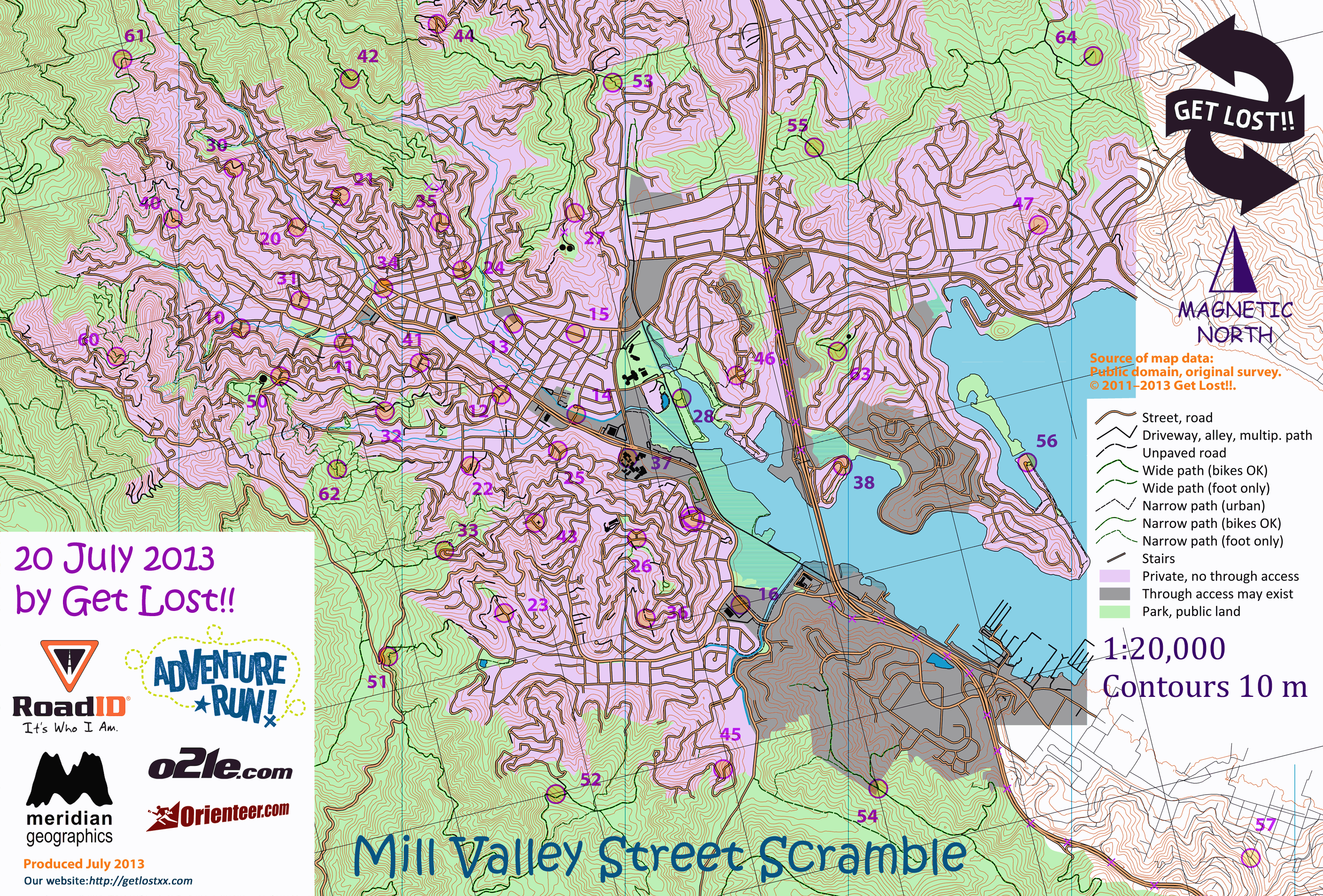
Street Scramble is in Berkeley, as well as all corners of San Francisco, Mill Valley, San Carlos, Los Gatos, Santa Cruz, and Monterey. And, of course, in most of Seattle and some of its suburbs.
Mill Valley in particular is a stellar bike venue. You can set an A-level MtbO point-to-point course there, not just a rogaine. Why don't we? there's a hunch that fewer people would turn out than for a rogaine, and these things take a lot of hours to organize.
As to having an actual Sprint in an actual city, parts of the Twin Peaks neighborhoods of San Francisco are certainly usable. Little traffic on a Sunday morning. They are on our list, a few years down the road once we've used the already mapped areas and ones with easier access to secure.
Aug 12, 2013 3:02 PM
#
Think Whistler Village would be great for sprint but maybe bit small for full urban? We can't do traffic free for london but do try time it to lessen traffic (early Sat/Sum am). Hardest thing is probably getting permissions from various borough councils/landowners, but it's getting easier. Look forward to see what you come up with!
Aug 12, 2013 3:23 PM
#
AZ:
Whistler Village itself would be too small for anything longer than a Sprint. On the other hand, it is adjacent to a ton of other maps / terrain / interesting urban settings. Now you mention it we could have a spectacular O-marathon, that would mix all kinds of great orienteering
(PS: For those that care, the Canadian Ironman is moving this year from Penticton to Whistler, and the run starts in the Village map, goes onto the Lost Lake map, then skirts the edge of the brand new world-class One Duck Lake map that will be used for the 2014 Canadian Champs middle distance)
(PS: For those that care, the Canadian Ironman is moving this year from Penticton to Whistler, and the run starts in the Village map, goes onto the Lost Lake map, then skirts the edge of the brand new world-class One Duck Lake map that will be used for the 2014 Canadian Champs middle distance)
Aug 12, 2013 3:27 PM
#
How about Avalon on Catalina Island off the coast of Los Angeles? Virtually no cars. It's a small town, though. I haven't been there.
Aug 12, 2013 4:15 PM
#
Avalon is pretty grid like, not very technically exciting. Then it's surrounding by steep hills with a few winding roads or trails on them.
Aug 12, 2013 4:23 PM
#
Oooh I like sprints that dip into other terrain, brain always goes as soon as I'm in a wood on a 1:5000 - classic for over running.
Aug 13, 2013 3:01 PM
#
If you're willing to go outside the US and Canada (but stay in N America), you could always use somewhere like this: https://maps.google.com/maps?hl=en&ll=17.986836,-9...
Aug 13, 2013 6:15 PM
#
Not incredibly technical, and not city, but decent, no cars, and possibility of sponsors: http://goo.gl/maps/CGKk7
Plus it's in Harriman :)
Plus it's in Harriman :)
Aug 14, 2013 4:58 AM
#
GuyO:
Sorry ndobbs, the Harriman Relays & Club Fest organizers beat you to it...
Unfortunately the Friday afternoon timing might not be too agreeable to management...
Unfortunately the Friday afternoon timing might not be too agreeable to management...
Aug 14, 2013 4:51 PM
#
Underground permissions can be tricky. For the A-Meet in Kansas City this past spring, there were original plans to have an underground sprint, but the access didn't work out.
Aug 15, 2013 1:15 AM
#
Yes Subtropolis denied permission. Another underground complex initially granted permission but then pulled it.
Aug 15, 2013 5:20 PM
#
Many years ago there was an orienteering event at Chislehurst Caves in SE London.
http://www.maprunner.co.uk/index.php?option=com_co...
http://www.maprunner.co.uk/index.php?option=com_co...
Aug 15, 2013 5:38 PM
#
John your link took me to something titled Levitra Viagra. Did they sponsor the event? Interesting, competing brands...
Aug 15, 2013 6:06 PM
#
Nothing like that when I click on my link (it should go to an orienteering archive page).
Aug 15, 2013 6:10 PM
#
Actually, if I click on the name of the event on the page that comes up, I do get the page you refer to. Weird.
Hopefully this link goes to the map of the event (and nothing else strange): http://www.maprunner.co.uk/maprunner/chislehurstco...
Hopefully this link goes to the map of the event (and nothing else strange): http://www.maprunner.co.uk/maprunner/chislehurstco...
Aug 15, 2013 6:58 PM
#
Safari on MacOS 10.6...
reset the browser, still happens...
also happened on Firefox and Chrome
sure it's not the site
http://www.maprunner.co.uk/
?
Rex
reset the browser, still happens...
also happened on Firefox and Chrome
sure it's not the site
http://www.maprunner.co.uk/
?
Rex
Aug 15, 2013 7:24 PM
#
I think the site is infected. it seems to happen every time a page has link to itself.
Aug 15, 2013 8:01 PM
#
8.8.8.8 is googles dns server, I was suggesting to try that to make sure you didn't have a malicious dns server that was redirecting you. But it does seem to be the site. On a page that links to itself, when you click the link it gives you the viagra ad.
Aug 16, 2013 5:39 AM
#
The trick with underground events is to not ask for permission. Just make sure the door is open and then start the race. I remember a really succesful parking garage event once... Also thinking of letting some anonymous club organise an event here: http://www.antus.org/bunker/Tyfors.htm
Aug 16, 2013 6:32 AM
#
I vote Jukola TC. Rapid mapping with those TC/tent area maps as base
http://cdn.jukola.com/wp-content/blogs.dir/5/files...
http://cdn.jukola.com/wp-content/blogs.dir/5/files...
One could use a bit more imagination in advance while planing those tent areas.
http://cdn.jukola.com/wp-content/blogs.dir/5/files...
http://cdn.jukola.com/wp-content/blogs.dir/5/files...
One could use a bit more imagination in advance while planing those tent areas.
Aug 16, 2013 7:58 AM
#
Or cars. First create map of random dots. Then label them in the carpark paddock with eg bamboo stakes. Marshalls direct all cars to park on the dots.
This discussion thread is closed.