Discussion: San Francisco ISOM map debuts July 14
in: Golden Gate Escape II (Jul 14, 2012 - San Francisco, CA, US)
Jul 2, 2012 8:25 PM
#
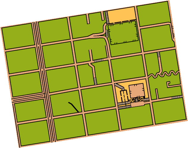
At 1:15000. Not shown yet: the contours, based on 5 ft. data from SF GIS. Putting San Francisco on the international circuit of "city-o-races" a la London and Venice...
Jul 3, 2012 12:11 AM
#
That is indeed the famous stretch of Lombard St. There is another switchback street in SF, which runs N-S. Anyone know where it its?
Jul 3, 2012 3:33 PM
#
Wow Rex. This is quite a project if you are mapping the entire city this way. Can't wait to walk it.
Jul 3, 2012 5:11 PM
#
What's with all the extra lines on the 1st street from the left edge?
If you look it up on Google Maps, it looks like medians and multiple lanes. In other words, a road that you can't just jaywalk across safely.
If you look it up on Google Maps, it looks like medians and multiple lanes. In other words, a road that you can't just jaywalk across safely.
Jul 3, 2012 9:57 PM
#
GuyO:
So, each of those lines represents a physical separation (eg, median)? If so the breaks are not accurately depicted as the middle line breaks through intersections but the next lines out are continuous.
Does ISSOM require/suggest/... that additional lanes, not separated by a median, be depicted with a line? For consistency, I would hope they would be depicted with just a wider paved area.
Does ISSOM require/suggest/... that additional lanes, not separated by a median, be depicted with a line? For consistency, I would hope they would be depicted with just a wider paved area.
Jul 3, 2012 10:43 PM
#
Your average pedestrian O-er will not worry too much about what the medians are. This is a 1:15000 map. What they worry about is lots of traffic. And 4 lanes on this map clearly indicates that.
Jul 3, 2012 11:13 PM
#
Yeah, at 1:15000, there's no way to perfectly map the streets.
Question: are you conforming to a map standard? 1:15000 would say ISOM, not ISSOM.
Speaking of roads and urban maps, I've got the Whistler Village map in front of me. It's 1:4000, and I noticed something ingenious about it. It shows two different, but legal, colors for pavement (symbol 529). The lighter color is pavement for pedestrians only, the darker color for vehicular traffic.
Jul 3, 2012 11:47 PM
#
I do that on all my sprint maps, Mr Socks, I think Simmo gave me the idea originally. It's debatable whether it's legal under a strict interpretation of ISSOM, but the improvement in legibility is so huge I don't really care.
Jul 4, 2012 12:05 AM
#
It's debatable whether it's legal under a strict interpretation of ISSOM
It seems like if you keep the brown to 30% for the darker shade, and, say, 10% for the lighter shade, you'd be fine, per ISSOM. It says that 0-30% is the range for urban areas, and 20-50% for non-urban. It doesn't say anything about mixing darkness within an urban area.
---
Heh, I know a Paul Dowling in Australia. He was an aussie flatmate of mine when I studied at Uni Newcastle in 2001.
Jul 4, 2012 12:46 AM
#
I always read those ranges as being "pick one value within this range to improve readability in your particular terrain", not "feel free to use everything from 0-30% on the one map." :)
---
Sadly I've never lived with anyone called Mr Socks (except in one particularly strange dream a few years ago), so it must have been someone else.
---
Sadly I've never lived with anyone called Mr Socks (except in one particularly strange dream a few years ago), so it must have been someone else.
Jul 4, 2012 4:12 AM
#
I used 3 shades in the range for a recent informal map - for public road vs. parking lot, vs. no-car-paved - looks nice/helpful. Though agreed this might not quite be what was intended by the range given in ISSOM.
Why are we talking about ISSOM on this thread anyway - the title is an ISOM map...
Why are we talking about ISSOM on this thread anyway - the title is an ISOM map...
Jul 4, 2012 4:41 AM
#
The map shown is definitely ISOM... that stretch of Lombard Street, for example, has parallel stairs that would have to be mapped on an ISSOM 1:4,000 map, but it's OK to generalize them out at 1:15,000.
Jul 4, 2012 5:00 AM
#
Why are we talking about ISSOM on this thread anyway - the title is an ISOM map...
Oh come on, that's nothing. We're still talking about orienteering 18 posts into a thread, surely that's some kind of record.
Jul 4, 2012 8:14 PM
#
In the parth of San Francisco shown, nearly all the olive would be solid buildings, from the street, anyway. Any thing else would probably be categorized as "Yards and Gardens", out-of-bounds by OUSA rule B.38.2(a).
Oh, and jj and bgallop are correct. The other crooked street is Vermont between 20th and 22nd.
Oh, and jj and bgallop are correct. The other crooked street is Vermont between 20th and 22nd.
Jul 5, 2012 5:29 PM
#
I thought the settlement symbol was out of bounds. (The olive green.)
This discussion thread is closed.