Discussion: anthills in eastern US
in: Orienteering; General
Feb 6, 2010 1:16 PM
#
Finding lots of mounds made by Allegheny Mound Ant in eastern US, was wondering if any O club has used it as a control location, after noticing it is in the IOF symbol list under "Land Form" (my guess it is for australian clubs...)
Feb 6, 2010 1:56 PM
#
feet:
jjcote used an ant hill (with a small jj-made mound and a few plastic ants) at the then-world-record 203-control course at Pawtuckaway some years back. But I don't think that's what you were asking for ;)
Feb 6, 2010 3:00 PM
#
wow, an O course with 203 controls ? tell me more, is there a map and/or clue sheet posted somewhere ?
Feb 6, 2010 3:11 PM
#
ok, I found it in clue sheet control # 194 at http://www.petergagarin.org/team/cluescroll.gif
Feb 6, 2010 6:14 PM
#
Don't have a map, but I can tell you it was at Pawtuckaway in New Hampshire (USA) and the controls were spaced < 200m apart, IIRC.
Feb 6, 2010 6:29 PM
#
Yeah, that one wasn't a real anthill, but it wasn't me who made it, it was Tony Federer (I picked the location on the end of the beach and supplied him with the plastic ants (from the Milton Bradley "Ants in the Pants" game). Controls were on average less than 100 m apart, by the way, and that record for number of controls has been boken several times since.
Back to the original question, Great Falls in Maryland has mapped anthills, and although I've never had a control on one, I remember running by one at the 1988 US Champs that did have a control (probably on the Orange course).
Back to the original question, Great Falls in Maryland has mapped anthills, and although I've never had a control on one, I remember running by one at the 1988 US Champs that did have a control (probably on the Orange course).
Feb 7, 2010 12:14 AM
#
they've been mapped and used in Finland... emit emits a nice crunchy sound when punching.
Feb 7, 2010 12:45 AM
#
Your guess that it's an Australian feature is correct; most often here they're around 1 metre high, but up in the Northern Territory they can get up to 3-5 metres.
Feb 7, 2010 1:19 AM
#
I believe that the original Pine Grove Furnace map in PA (used for an Intercollegiate championship in the late 90's) had an anthill on the map. It was usuable as a control feature, but was not used at that event. I don't know if a local meet has used that particular site.
Feb 7, 2010 6:47 AM
#
here are some pictures of the 100 or so anthills I found in a stretch of 400 meters in length, and 10 meters wide, on what was probably a logging road 50 years ago, but now covered with underbrush and grasses. They seem partial to rough clearings, and my guess it is because they need grass. RJM of NEOOC gave me some biology lesson by email today, saying "they farm other insects as livestock, carrying certain butterfly caterpillars up into trees during the day to feed, and then back down into the nest at night, when the ants ‘milk’ the caterpillars for honeydew"
http://picasaweb.google.com/sherpes4/Anthills#
http://picasaweb.google.com/sherpes4/Anthills#
Feb 7, 2010 10:33 AM
#
http://www.e-village.jp/earth-c/html/9909sep/gif/a...
This is a termite mound and may explain why we map them.
This is a termite mound and may explain why we map them.
Feb 7, 2010 12:06 PM
#
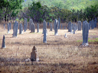
OK, it has started. Reminds me of a scene from the first Crocodile Dundee movie. "Call that a termie?".
These are about 2 metres high, oriented nth-sth blades.
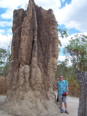
These are a bit higher.
In fairness, both these photos are taken at sites on the standard Northern Territory tourist routes. I have never seen anything near this on an orienteering map. Maybe our NT orienteering correspondents can give us the real deal.
These are about 2 metres high, oriented nth-sth blades.
 |
| From Termies |
These are a bit higher.
 |
| From Termies |
In fairness, both these photos are taken at sites on the standard Northern Territory tourist routes. I have never seen anything near this on an orienteering map. Maybe our NT orienteering correspondents can give us the real deal.
Feb 8, 2010 2:06 AM
#
There was a 3.5 metre termite mound used as a control site at the 2005 NT Championships.
This discussion thread is closed.