Discussion: ISOM Interpretation: 418 Prom tree vs 410 Veg, fight
in: Orienteering; General
May 20, 2021 1:36 PM
#
Hello -
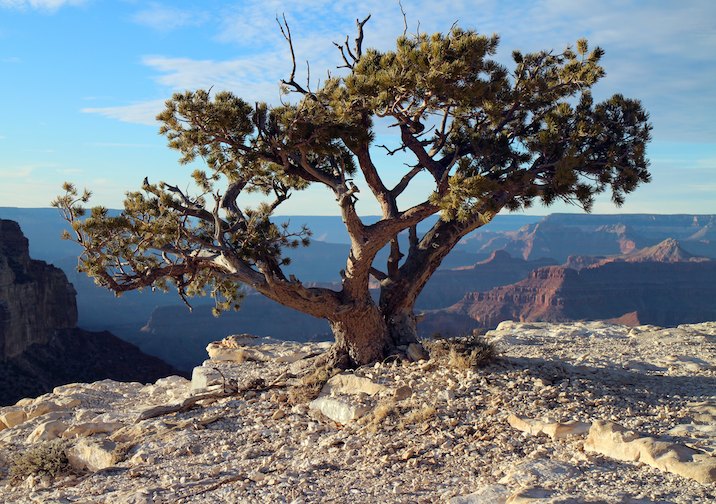
I'm mapping an area where a lot of relatively uncommon and very distinctly sized and shaped Colorado Pinon trees (418) occur next to or within blobs of scrub oak (410).
A conservative (and I think correct) interpretation of ISOM's gap rules would reject mapping the 418 inside or in close contact with 410. The area occupied by each of these trees is as un-runnable as is the scrub oak, further supporting the inclusion of them in the blob of 410.
On the other hand, not mapping them gives up a great deal of extremely helpful navigational information.
I think not mapping them unless they are free-standing is the way to go, but I'm curious as to what others' opinions are.
On a similar vein, I have some cases of 418's in rough open close together but too small to map as 405 - cheat on the min area of 405, overlap the 418's (gap violation), or write it off as rough open scattered trees?
Thank you.
May 20, 2021 2:23 PM
#
@CompassCoyote, do you have photos in terrain that shows what an orienteer see?
May 20, 2021 5:41 PM
#
I'm sorry, I do not. I have yet to see this map in full leaf, at which point the trees that I find so prominent now may be less so.
May 20, 2021 7:38 PM
#
Hi Gord -
Not quite the runner's view, but please see if this helps: https://1drv.ms/u/s!AmMT5E-2wBxLhyPNfKpmFumfwwYF?e...
A: two (otherwise prominent pinons glommed into a blob of scrub oak
B: four very prominent pinons too close together to faithfully show as 4x 418 and too small to map as 405 Forest
C: one standalone pinon.
From Google Earth.
Thank you.
May 20, 2021 8:18 PM
#
This is an ISOM map, not an ISSOM map? I'd be inclined to map the whole area as rough open with scattered trees and be done with it. Maybe with some blobs of fight for the scrub oak, but it's hard to know without seeing it in person whether you'd go nuts trying to decide which ones belong on the map. I mean, it looks like you can get through the area in any direction you like without being significantly slowed down. That's the main original purpose of showing vegetation on a map. Navigating by counting bushes? Better to use other stuff like contours. You don't want to make the map so busy that it becomes hard to use, that defeats the purpose.
May 20, 2021 9:26 PM
#
Good point, JJ, thank you. It's an ISOM map. I'll walk a version of the map as such and see what it feels like. My base/starting point for the 410 Veg, fight symbolization is a vectorized product of analysis of the CHM in R, and I can easily set that to only draw larger massive scrub oak obstructions where they exist.
May 20, 2021 10:09 PM
#
What a nice problem to have. At a brief glance it looks like a nice area to go orienteering.
I did not know until today what a Colorado pinon tree looked like. In shape they are much like Florida live oaks growing in the open where they get to spread and the deer tend to eat all the seedlings around them. There, they are definitely prominent tree material. However in the middle of an oak hammock (forest) they are rarely so prominent as they tend to grow taller and straighter.
You know for no particular reason other than the available base material is so good I was recently playing with mapping similar terrain in Texas hill country. Of course I can only look at the terrain and trees from satellite images so just as with your terrain I was reduced to guesses. It was frustrating trying to distinguish small blocks of forest vs scrub vs mapping the rough open and rough open/ trees. Good thing I was only play mapping.
I agree with JJ. To me from the top those pinons do not look so prominent. Better to capture and map the thick vegetation. However one exception: that larger area to the north and a bit east of A I think is large enough to be mapped rough open only.
May 20, 2021 10:47 PM
#
C'mon out - subject to permitting, our meet is scheduled for Sat 11th Sept.
Just for kicks, I'd be happy to to point my R script at a tile of the LiDAR for your Texas terrain and see to what extent I can tease out the different veg. My script has no real intelligence, machine learning, or botanical expertise, but it leverages some clever functions that let me filter based on height and (to an extent) density of height cells in a CHM raster. I.e., it only works when the heights of different classes of veg natively correspond to ISOM symbology. Looking at the Infrared or NDVI versions of the imagery might help segregate veg type, too.
Yep, there's lot of area similar to that the the NE of A in that image on the southeastern part of the map; those bushes are mostly >1m high, but they offer little or no real impediment to running. Use of 404/green dots would be informative and not inaccurate, but I think not worth the cost of a blotchier map.
May 20, 2021 11:24 PM
#
What's an ISSOM?
I've seen single trees mapped as 405 (rather than 418) in open or rough open terrain. Not sure if it breached minimum area rules but it seemed to be useful on a farmland map.
In your example though I'd focus on the runnability in areas where the trees are within thick bush (so ignore mapping the trees and map the bush density instead) and map the others as 404 or 405 if they're too numerous to map or not helpful to navigation. Even in your example C the tree looks to be too close to the bushes/trees to the SW to be useful to map on its own, especially at 1:10,000.
May 20, 2021 11:31 PM
#
Galen : I'll e-mail you. But forget the 404.001 and go 404.000 (IMHO)
May 20, 2021 11:56 PM
#
ISSOM = Sprint Map standards, i.e., comparatively fine detail on maps at 1:4,000 scale
A number of our maps in CO/WY use small round white dots for individual trees. Mikell Platt has used that on maps in WY that are rife with boulders to great effect - blobs of rock amongst 417/418 dots for trees (as the alternative to dots of 405) would be unreadable.
I'll try to get some good eye-level pics in 2-3 weeks' time (when the scrub oak will be somewhat in leaf) to give a better idea of the situation.
May 21, 2021 12:32 AM
#
I had a very similar situation with spruce trees in Manitoba sand hills. When you first start mapping the feeling is they should be mapped as prominent trees but that idea quickly proved impractical as they were often in larger areas of dense vegetation like your piñons . Mapping the prominent tree in small patch of green was a mess and obscured the (far more important) boundaries of the green. But once you decide to not map those as prominent trees then you can't map any prominent trees as from a distance you cannot see if there thick low vegetation below or not. So I decided to map all trees (single or in groups) as just patches of vegetation: a blob of white or green in the yellow.
I googled images of piñon pines :
it seems a lot of them have canopy right to the ground so can quite easily be mapped as just small thickets (blob of green) The ones that have higher canopies are more difficult to map. Here's a few examples of how I might approach it
A https://www.coniferousforest.com/wp-content/upload...
B https://www.inaturalist.org/guide_taxa/635573
C https://www.alamy.com/stock-photo-two-needle-pinyo...
D https://www.waterwiseplants.org/find-a-plant/pinyo...

it is not a perfect solution (eg: a white blob in 50% yellow is not very distinct on the map while the tree it is representing is often very distinct ) but mostly it worked OK.
I googled images of piñon pines :
it seems a lot of them have canopy right to the ground so can quite easily be mapped as just small thickets (blob of green) The ones that have higher canopies are more difficult to map. Here's a few examples of how I might approach it
A https://www.coniferousforest.com/wp-content/upload...
B https://www.inaturalist.org/guide_taxa/635573
C https://www.alamy.com/stock-photo-two-needle-pinyo...
D https://www.waterwiseplants.org/find-a-plant/pinyo...
it is not a perfect solution (eg: a white blob in 50% yellow is not very distinct on the map while the tree it is representing is often very distinct ) but mostly it worked OK.
May 21, 2021 1:18 AM
#
Correct - from a run-ability perspective, those Colorado Pinons are 410 Veg, fight. Trouble is, they're prominent, and especially so when free-standing. I'm still inclined to map very free standing such trees with a high hurdle, say no scrub oak or other trees within 20m, or something like that.
May 21, 2021 1:21 AM
#
ISSOM = Sprint Map standards
I was referencing the fact it's been superseded by ISSprOM as of last year.
I was referencing the fact it's been superseded by ISSprOM as of last year.
May 21, 2021 3:01 AM
#
I'm still inclined to map very free standing such trees with a high hurdle, say no scrub oak or other trees within 20m, or something like that.
I came to a very similar conclusion at first but soon abandoned that idea. The trouble is that unless you are close enough to a tree to see what is under it a 20m tall tree with oak scrub under it looks the same as a 20m tree without - but only the latter will be mapped as prominent, which is confusing.
I came to a very similar conclusion at first but soon abandoned that idea. The trouble is that unless you are close enough to a tree to see what is under it a 20m tall tree with oak scrub under it looks the same as a 20m tree without - but only the latter will be mapped as prominent, which is confusing.
May 21, 2021 7:04 AM
#
There may be an increasing tendency to ask, how can we fit more detail into the map? Another way to approach mapping is to ask, what can we leave OFF the map? After all there ARE areas with uniform trees (or non-trees) that we are quite happy to show as a large area of colour. If there are random tree-trunks or blobs of thick vegetation on the ground we just run round them.
May 21, 2021 2:31 PM
#
I'd be wary of mapping individual trees. The symbol is 'Prominent large tree'. If all the trees in the area are the same species, how is any one of them 'prominent'? Also, they don't seem particularly large (10-20m as described in C above).
Re-read ISOM 2017, especially 2.2 in the preamble: 'The map shall only contain features which are obvious on the ground to a competitor at speed.'
Mapping trees as individual features also invites course planners to put controls there. Maybe ok for Sprint, but in forest comprising a single species of tree definitely not ok.
Presumably there are other features around - looks like there are larger rocks, and hopefully the contours will be interesting - so as gruver says, people will just run around the trees and green to navigate to the other features. It also looks very stony so peoples' eyes will most likely be directed at the ground and they won't be looking up at trees.
May 21, 2021 3:51 PM
#
Simmo, I'm guessing you have never been orienteering in central or south Florida because there you will find forests that are largely but not exclusively one species of tree and the oddballs are very distinctive even if not larger. than the majority. There you will not find rocks, rock faces or even interesting contours. It rains a lot but the rain does not form in streams; it just seeps into the sandy soil. There are no gullies, no spurs. In central and south Florida there are generally three types of features we can use for control points: trail junctions, bends etc, distinct trees, root stocks, thickets and marshes. Sometimes a man-made feature sneaks in, too.
But the debate on distinctive trees is endless. Last year I was making a map in the Ottawa, Canada area. I came across a shag bark hemlock of a pretty fair size. Man, that's distinctive I thought and I put it on the map. It really stood out in that bit of the forest.
However another guy took over the map and I guess didn't think the tree distinctive as when the map finally came out in a competition that tree was missing from the map. If I ever got the map back the tree would be back. And on it goes.
May 21, 2021 6:45 PM
#
Botanists are the worst. Rare species stand out in they eyes, for rest of us those are just regular bush."but that's Picea abies f. virgata, not a regular Picea abies".
May 22, 2021 1:05 AM
#
gordhun, one of our West Aus maps had a very distinctive white gum on it. The mapper at the time put it on the map as a distinctive tree as there were no other white gums in the whole area and it was *very* useful for navigation. Problem was the whole map had been drawn by three different people so suffered from inconsistencies and in an effort to standardise we brought in a professional mapper from the east and what did he do? Got rid of the distinctive tree.
May 22, 2021 2:48 AM
#
Really Ricky - how hard is it to just add that one tree back onto the map ?
May 29, 2021 1:24 PM
#
I have to keep telling myself, "this is orienteering, not landscape architecture." :-) I'm planning to be back on the map Friday the 4th, and will take and post some pictures of the 418 'Prominent' (to my eye...) trees.
Jun 6, 2021 11:29 PM
#
Follow-up: I was on-site on Friday, took a bunch of pictures, but the difficulty I had with trying to get good pics confirms the sentiment of those who pitched in; what I'd been seeing as 'prominent' really are not so prominent as to be worth mapping, and run-ability (none) is better indicated by including the area occupied by such trees as 418 Veg, fight.
The trouble with the pics was that I took them close enough so as to be able to ID the A, B, and C trees/groups, but in doing so lost all sense of surrounding veg, and therefore the ability to share something by which prominence could be assessed.
I've gone ahead and have deleted a large number of not really prominent trees, and am working up a much more restrictive application of 'prominent' for this map.
My thanks to all for your input.
Jun 7, 2021 12:08 AM
#
Deleted as in cut down? That's pretty serious work to make mapping easier.
Having said that, someone was recently telling me about the native cherry trees that used to get mapped on some Vic and NSW maps back in the days of mass printed maps with hand drawn courses. On one iteration the course planner or organiser discovered an unmapped cherry tree. With so many maps having already been printed what was the solution? Cut down the tree.
Having said that, someone was recently telling me about the native cherry trees that used to get mapped on some Vic and NSW maps back in the days of mass printed maps with hand drawn courses. On one iteration the course planner or organiser discovered an unmapped cherry tree. With so many maps having already been printed what was the solution? Cut down the tree.
Jun 7, 2021 1:09 AM
#
There's a famous story about that happening many years ago in Scandinavia (I think it was Sweden), but it wasn't a tree, it was a small unmapped cliff. They called the military, who send out some guys with explosives. Boom. Problem solved.
Jun 7, 2021 3:27 AM
#
In the BO* days when cartographers used stencils a stray boulder came off the stencil onto the black overlay and ended up being printed. We used to print several years' supply of maps in those days (no digital printing!), so a team was sent out to build a rock cairn at the non-existent boulder's location.
*Before OCAD (or maybe bad old)
*Before OCAD (or maybe bad old)
Jun 7, 2021 7:02 PM
#
I've heard that the latest ISOT (Int' Specification for Orienteering Terrain) requires that the terrain be a readable and suitable generalization of the map... :-)
This discussion thread is closed.