Discussion: Desert Mapping
in: Orienteering; General
Apr 30, 2021 11:54 PM
#
I'm working on a map of a site that is pretty open desert terrain - similar to Anza-Borrego. We are hoping to use this site for a US Champs bid for the Long courses. What is people's opinion of the mapping of open desert terrain using white instead of yellow? Would you rather have the white base even though it's not to spec?
May 1, 2021 12:05 AM
#
We justify using white for our desert terrain because it is "[t]ypical open forest for the particular type of terrain." Of course, we do have abundant saguaros and small trees, so it really is more of a forest than some scattered bushes and pebbles on sand. There's just not really a canopy.
I wouldn't have an issue with white being used if there's no forest anywhere on the map but I am probably not the kind of person you'd need to worry about.
I wouldn't have an issue with white being used if there's no forest anywhere on the map but I am probably not the kind of person you'd need to worry about.
May 1, 2021 12:20 AM
#
I think Cristina nailed it -- if there is no regular forest on the map, I think mapping it as white would be fine (obviously, let people know). If there IS forest that would normally be mapped as white, that would create a bit of a problem, in terms of how to distinguish.
May 1, 2021 12:33 AM
#
I don't think you could argue that point well enough to label the map as ISOM compliant.
I also don't really see the downside to a predominately yellow map vs a white map. It's not like the printers are charging us by ink usage, so print the whole thing yellow with brown contours and black rock features if that is what it really is.
I also don't really see the downside to a predominately yellow map vs a white map. It's not like the printers are charging us by ink usage, so print the whole thing yellow with brown contours and black rock features if that is what it really is.
May 1, 2021 3:28 AM
#
Full ink coverage maps often have a tendency to crinkle and flake when folded. Plus the whole color overprinting thing gets more complicated and harder to get right. I'm with Cristina and Dick.
May 1, 2021 7:35 AM
#
Is desert "rough open"? If so it would be 50% yellow. And since IOF lets you reduce full yellow if there's a lot of it, reduce the 50% to 35%. (I think there's an oversight in the ISOM here, and 35% would be compliant. Well compliant with me anyway.)
May 1, 2021 12:12 PM
#
That would be reasonable if you could print the yellow as a dot screen.
May 1, 2021 3:08 PM
#
Just wanted to say that I'm very excited about the possibility of a US Champs long in that terrain.
May 1, 2021 3:08 PM
#
Just wanted to say that I'm very excited about the possibility of a US Champs long in that terrain.
May 1, 2021 3:51 PM
#
This issue sounded familiar to me. I thought I'd seen it before. Then I remembered. Back in 1990 I competed in an area in South Wales UK called Pwll Du, Blaenafon. It was a former coal mine area, almost entirely grassed over but entirely treeless. There were a few patches of Open Land with the usual yellow. The rest was classed Rough Open with the yellow reduced so it looked like a very pale beige. It may not have been kosher by whatever was the equivalent of ISOM in those days but it was very effective. It was easy on the eye and it made the contour detail - the important detail- pop out.
May 1, 2021 4:03 PM
#
There's also the joke suggestion that has been made from time to time, that it's vaguely possible could work: print the maps on yellow paper.
May 1, 2021 5:03 PM
#
Maps on yellow paper? Already been done. I recently was at a school in Florida that has their map printed in black and white on yellow paper. Very cost effective.
May 2, 2021 1:58 AM
#
@smittyo: Since the rules state that maps *shall be* (my emphasis) prepared to ISOM, and since there's nothing in the rules that allows for wiggle room in waiving certain rules or rule provisions as long as there is popular opinion for doing so, it's hard to see the relevance of a straw poll at Attackpoint.
You're the mapper and the only one on the ground, so what is more interesting--at least to me--is what is your opinion on the matter, and what is the compelling argument for entirely omitting a color which could be expected to cover more or less the entire map? That would be a very significant departure from ISOM, and if there is no compelling argument to be made to omit yellow, then why even raise the question?
You're the mapper and the only one on the ground, so what is more interesting--at least to me--is what is your opinion on the matter, and what is the compelling argument for entirely omitting a color which could be expected to cover more or less the entire map? That would be a very significant departure from ISOM, and if there is no compelling argument to be made to omit yellow, then why even raise the question?
May 2, 2021 3:51 AM
#
Omitting the yellow would be a dangerous move. You only need one small patch of "forest" in the terrain and you need that yellow. But the danger is, if you have made the decision to not use yellow you then find yourself coming up with weird ways of showing that one forest patch and still not use yellow.
May 2, 2021 4:21 AM
#
Take the no regrets option. Map the yellow and then if you don't like it just turn off the symbol. If you need to be compliant for a WRE etc, than turn it back on.
May 2, 2021 5:35 AM
#
Or use OCAD's new mode to automatically fill empty areas. They have lots of customers with deserts.
May 2, 2021 1:39 PM
#
If it's Tillamook Old Fashioned Vanilla Ice Cream, I'd go with white. If it's Tillamook Vanilla Bean Ice Cream, then I'd go with white with the occasional bit of stony ground. But if it's Tillamook French Vanilla Ice Cream, then I'd go with yellow.
May 2, 2021 5:34 PM
#
Dangerous? There's no danger if you reserve the option to print the yellow until printing time. When mapping, there's nothing to note for the bulk of the area. If you happen to find a patch of forest, you make note of it. I mean, how is this going to be drafted anyway? One big chunk of rough open that covers the whole map. Which you don't need to even put in until the map is done. If you need to cut a hole in it, you do that. If you decide not to print the yellow, you just hide the symbol. It's not as if the maps are being printed bit by bit as you do the fieldwork. And it's not as if, when you find the patch of forest, you have to go back and look at the rest of the open desert again to make sure no trees have sprouted.
I think I've been on a map like this, Dead Indian Canyon near Palm Desert. I need to dig out that map to see what was done there. I don't remember a lot of yellow, but I haven't looked at the map in a long time.
I think I've been on a map like this, Dead Indian Canyon near Palm Desert. I need to dig out that map to see what was done there. I don't remember a lot of yellow, but I haven't looked at the map in a long time.
May 2, 2021 5:42 PM
#
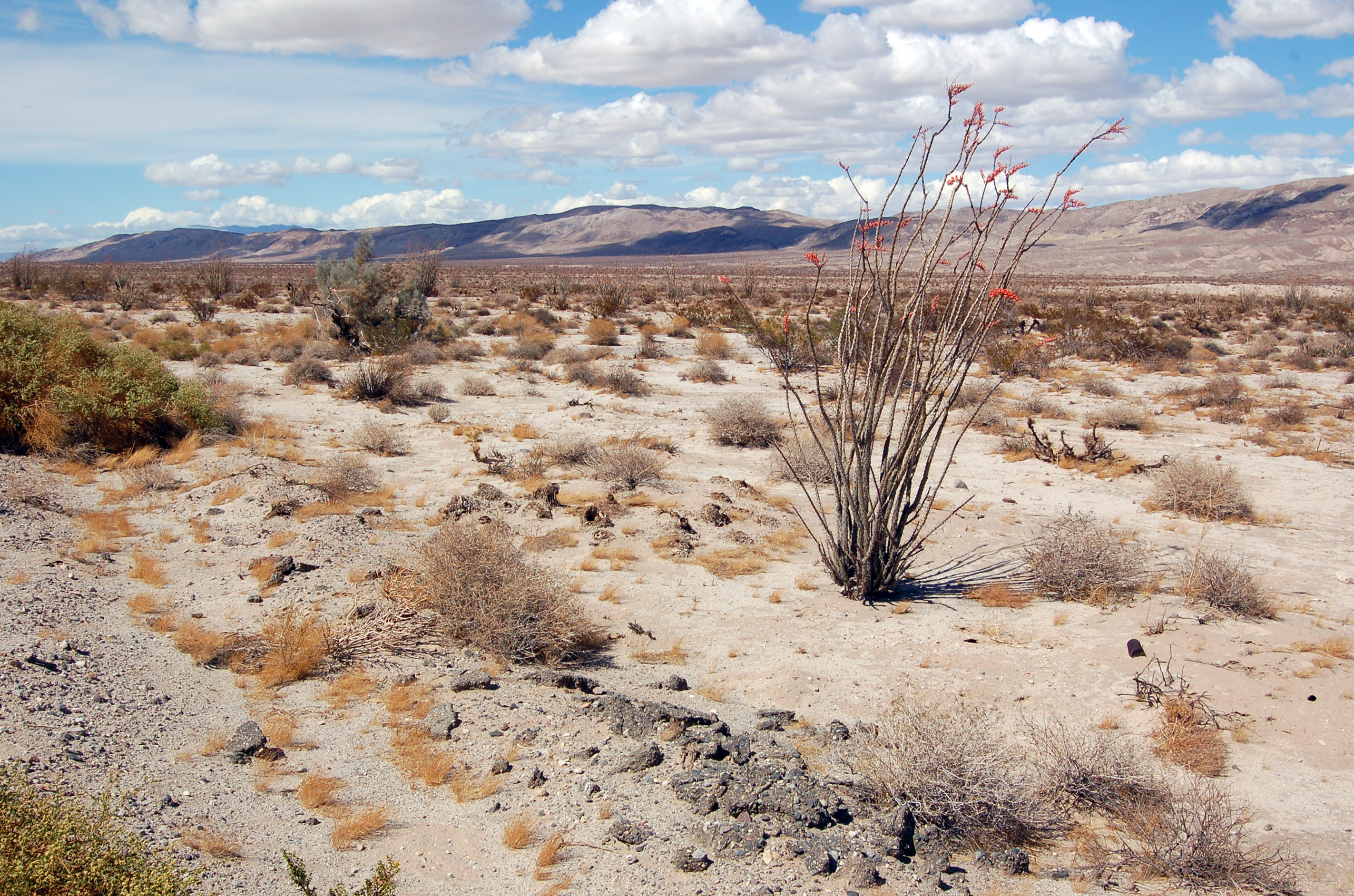
Pink Socks, our desert looks like this 
does Tillamook make a chocolate chip cookie dough flavor? Or maybe it's something else?
does Tillamook make a chocolate chip cookie dough flavor? Or maybe it's something else?
May 2, 2021 7:44 PM
#
In an area like the one in South Australia used for the National League last weekend, the shrubland area in the foreground of Cristina's picture would be mapped as white.
May 2, 2021 8:14 PM
#
We may be talking about terrain that looks like this:

No "forest", not much chance of finding any.
Oh, wait, here's some forest!
No "forest", not much chance of finding any.
Oh, wait, here's some forest!
May 2, 2021 8:19 PM
#
Yeah, there's just a wee bit of diversity in what "desert" can mean. Harder to argue that the terrain in your picture (Anza-Borrego?) *should* be white, though I don't know that it would much matter to a runner.
May 2, 2021 10:48 PM
#
Time to go find a new printer if your full colour maps 'crinkle and flake when folded'.
May 3, 2021 2:56 AM
#
@Swampfox. The sanctioning committee has the power to waive rules. When I sent a similar message to the sanctioning chair it was suggested that I post here to see what the people who would actually run on the map might think.
Thanks for all the discussion.
Here's picture of the terrain showing what might qualify as white forest.

Thanks for all the discussion.
Here's picture of the terrain showing what might qualify as white forest.
May 3, 2021 3:04 AM
#
I took a look at the Dead Indian Canyon map, and it was not what I remembered. Much of the area was in fact mapped as light yellow. However, the higher elevations were mapped with a weird light gray that was described in the legend as "broken rock, difficult to walk", or something like that. I wasn't a fan, particularly because the print quality wasn't the best, very speckled, which made it harder to read the contours (this was relatively early in the days of laser/inkjet printing). It was also very difficult orienteering in those upper sections.
May 3, 2021 2:47 PM
#
Presumably even the Sanctioning Committee would want to see the reasoning behind a request for a rules waiver, and would not grant it in the absence of same.
May 3, 2021 3:00 PM
#
I think it would be ok with a white base (assuming no actual open forest in area). It makes it easier to read the contours, which I guess will be quite detailed.
It would be easy to just toggle yellow on/off as needed.
It would be easy to just toggle yellow on/off as needed.
May 3, 2021 5:41 PM
#
In Greenland all the maps are white. Would be a completely waste of yellow ink otherwise. But I don't think they care about ISOM too much.
May 3, 2021 6:21 PM
#
After years of running on the Anza Borrego map I realized that reading complex contours is easier on a white background than a yellow background. This is better for the competitors. Who are we trying to please anyway? The purists who probably won’t attend the event or the orienteers who will be out there navigating.
May 3, 2021 10:45 PM
#
As an orienteer who is out there navigating, seeing a white map would lead me to believe the area was forested. My brain has kind of attuned itself to map colours over the years.
May 4, 2021 7:09 AM
#
I guess I would make a white forest symbol that knocks out yellow. So one large yellow object at background, no need to cut any holes holes, just draw white on it. I'd set that yellow symbol "protected" so it would be visible but not selectable so it would not disturb me when I am drawing and selecting other symbols.
May 4, 2021 11:32 AM
#
One argument would be that in the future you (or someone else) might map other nearby areas, and eventually there would be a map that would consist of this open desert, but that would also contain some legit forest. It would seem that that would have to exist somewhere, as you move toward the real forests of the world. And there would be value to having the mapping be consistent across the maps. But that still leaves the question of whether you'd print the yellow on any given printing of the map.
May 4, 2021 5:34 PM
#
Jagge, that symbol already exists in OCAD ISOM 2017 symbol set (405.000 Forest) and AFAIR was also in earlier symbol sets. No need to reinvent the wheel.
May 4, 2021 6:02 PM
#
I have drafted maps that are mostly yellow, with white patches, back in the early days of 0CAD, maybe it was before you could even cut holes in things. That was a hassle!
May 5, 2021 2:18 AM
#
Just to be clear, while it does make a slightly easier drafting job to leave it white, that wasn't the motivation behind the question. It really is about what @Geoman said. I have also run many times at Anza-Borrego and I personally prefer the legibility of the white map. But I also know that it's not to spec. Other than general legibility of detail on top of yellow vs white, my other concern is that it can be more difficult to distinguish blue from green when on yellow vs white. I'm not sure there are features on this map where it makes a difference, though.
May 5, 2021 2:29 AM
#
I often can't tell light green from light yellow, so that's a good reason for this handicapped guy. If there are patches of light green on the map, then if the whole thing is light yellow, I may not see them. (This is a problem I sometimes have to live with, I've headed for things that I expected to be fields only to discoved when I got there that they were thickets.)
May 5, 2021 5:49 AM
#
Last time I tried that default 405 symbol I could not draw green bushes on it. I haven't tried lately, but I suspect that wheel may still be rectangular. But that was in OOM, I think I have never tried that in Ocad, maybe it had got it better?
May 5, 2021 5:53 AM
#
Depending on the complexity of the map, you could cut holes in the white and filll them with green.
May 5, 2021 5:55 AM
#
The OCAD symbol and colour sets are changing all the time. Problems come, problems go. As of now 405 is on top of 401 and 403. But I dont like to depend on colour order, I cut holes.
May 5, 2021 7:31 AM
#
I change the colour order based on what I want to see on top. For some reason in some templates I get area green higher up the order than point green, which leads to distinct trees not appearing in paved areas so I just recolour them (i.e. use area green for trees). Talk about breaking specs!
May 5, 2021 9:24 AM
#
I have to say, https://lh5.googleusercontent.com/AOjMi51midmR63Ye...
worked fine, rough-open yellow = farmland, white = bog (where heather is the tallest vegetation). There are a couple of palm trees on the island.
worked fine, rough-open yellow = farmland, white = bog (where heather is the tallest vegetation). There are a couple of palm trees on the island.
May 5, 2021 1:36 PM
#
Google needs to get its act together, 403 is Rough open land, not 403 Error (forbidden)
May 6, 2021 6:05 PM
#
Found this sample from an open land in Ireland
http://doma.leberkaesbriegel.de/show_map.php?user=...
They used very light yellow. Next day was on this map were they used normal rought open land.
http://doma.leberkaesbriegel.de/show_map.php?user=...
Both worked fine for me but I think a complete white map would have confused me.
http://doma.leberkaesbriegel.de/show_map.php?user=...
They used very light yellow. Next day was on this map were they used normal rought open land.
http://doma.leberkaesbriegel.de/show_map.php?user=...
Both worked fine for me but I think a complete white map would have confused me.
May 6, 2021 6:09 PM
#
If the map is basically all white or all yellow or all pink or whatever, I feel like my brain just ignores that background color and reads everything else.
May 7, 2021 2:33 AM
#
Print it white, offer yellow glasses to anyone who thinks they'll need them to avoid confusion.
May 7, 2021 8:50 AM
#
Steffen's 2nd map is typical of the light yellow used for majority of farmland maps in NZ. Maybe it's what I'm used to but works well in most cases with all over detail clearly legible, only would be problematic where there were large blocks of both heavily grazed ('open') and ungrazed ('rough open') that needed to be distinguished.
I definitely want to know more about what's going on in that first map though!
I definitely want to know more about what's going on in that first map though!
May 7, 2021 8:56 AM
#
Steffen are you saying these two maps were used one after the other, using different mapping approaches? Nice idea for the knockout sprint, give runners a 20sec look at maps using different symbols and they have to choose one.
May 7, 2021 11:04 AM
#
Turf cutting. That area / activity was my family (Grandad) business in the 1940s/1950s.
May 7, 2021 11:20 AM
#
Translating for those who are not from Ireland, I believe "turf cutting" means harvesting peat for burning. (To American ears, it sounds like a synonym for "mowing the lawn".)
May 7, 2021 1:07 PM
#
@gruvever
This was one weekend. First map was Saturday in a turf cutting area. Second map was Sunday on a kind of Fjell. Was orienteering in NI the week before andthe maps there were like the second map. So I was already used to that kind of mapping.
This was one weekend. First map was Saturday in a turf cutting area. Second map was Sunday on a kind of Fjell. Was orienteering in NI the week before andthe maps there were like the second map. So I was already used to that kind of mapping.
May 7, 2021 2:21 PM
#
A couple of examples from the UK where white has been used for the open fell.
https://www.mdoc.routegadget.co.uk/rg2/#289
https://www.sroc.routegadget.co.uk/rg2/#364
it seems to be a Lake District thing. It's not really a problem. You can see when you're up there that it isn't a forest.
https://www.mdoc.routegadget.co.uk/rg2/#289
https://www.sroc.routegadget.co.uk/rg2/#364
it seems to be a Lake District thing. It's not really a problem. You can see when you're up there that it isn't a forest.
May 7, 2021 2:25 PM
#
From the event details for the first of those two maps
"Maps are drawn to ISOM 2017."
and
"On the ‘mountain days’, day 1 at Silver How, Day 2 at Angle Tarn Pikes and day 4 at Askham Fell, the maps will NOT have the ‘rough open screen’ even though the entire areas are ‘rough open’. The maps will have a ‘white, open forest’ colour to improve clarity and save ink!"
This discussion thread is closed.