Discussion: Straight-line in the US
in: Orienteering; News
Apr 18, 2020 7:10 PM
#
For every US orienteering nerd, where in the US could we find a straight line longer than 35.2k on terrain that is open and useful for orienteering?
It's helpful if there are currently maps in existence of all or parts of the area. Ruggedness of said terrain is not an issue.
It's helpful if there are currently maps in existence of all or parts of the area. Ruggedness of said terrain is not an issue.
Apr 18, 2020 7:28 PM
#
I bet you could find that with at least some percentage mapped in Laramie, Bend, and the eastern WA scablands (Fishtrap et al).
Apr 18, 2020 7:31 PM
#
I suppose I should add that the higher the percentage of the area currently mapped, the better. Is there anywhere I can see all the maps in Eastern WA, LargeBillFashion?
Apr 18, 2020 7:39 PM
#
From the southern tip of Harriman down by Suffern to the north edge of Black Rock Forest looks like just about that distance, using the longest line that misses the artillery range, and almost entirely mapped. Is that what you're trying to outdo?
The longest line in the Medicine Bow (Laramie) is 22.8 km.
The longest line in the Medicine Bow (Laramie) is 22.8 km.
Apr 18, 2020 7:44 PM
#
Yeah, if we can get the logistics worked out, why not go after a world record?
Apr 18, 2020 7:51 PM
#
Too bad Laramie doesn’t have the length - would be a bit faster running that a Harriman line.
Apr 18, 2020 8:22 PM
#
@1000Scandi other than Fishtrap itself I think Eric has mapped a bunch of the area to the SW, dunno how much or to what quality though. Pink Socks likely knows more about it.
I should add that if pre-existing O-quality maps is a high priority, this probably isn't the best bet. The terrain is there though.
I should add that if pre-existing O-quality maps is a high priority, this probably isn't the best bet. The terrain is there though.
Apr 18, 2020 10:51 PM
#
Of the scablands that might get used for the rogaine this fall, the longest straight line there is ~29.4 km.
That's a combination of federal BLM, Washington DNR, and two private landowners. One of whom owns huge chunks of area, including the Fishtrap Lake orienteering map, and always grants us permission. The other landowner has a smaller area that we don't have an agreement with yet, and this area is smack in the middle of the straight line, so if we don't get that specific access, the longest is ~15km.
The orienteering map actually doesn't cover that much of the 29.4 km. There's some LIDAR for the rest, but some doesn't have LIDAR yet.
I should also mention that the 29.4km straight line crossed an uncrossable lake (Fishtrap Lake). I'm not sure exactly what you're going for here.
Also also, the scablands keep going beyond this line, but are either owned by private landowners that have never been contacted for orienteering permission, or are things like wildlife refuges that don't allow off-trail access.
Apr 18, 2020 11:45 PM
#
I'm guessing you looking for a location to beat this
https://www.livelox.com/Viewer/Langfredagslangstra...
35.2 km straight line orienteering with a map corridor of 200m width.
https://www.livelox.com/Viewer/Langfredagslangstra...
35.2 km straight line orienteering with a map corridor of 200m width.
Apr 19, 2020 12:25 AM
#
Yep!
Thanks for the info, LargeBillFashion and Pink Socks. Eastern WA is still a possibility and certainly a lot faster than many other places I'm looking at.
Thanks for the info, LargeBillFashion and Pink Socks. Eastern WA is still a possibility and certainly a lot faster than many other places I'm looking at.
Apr 19, 2020 12:30 AM
#
North of Rte. 24 in Colorado, in the vicinity of Lake George, there might be a path that crosses Saylor Park, Lake Manitou, Crystal something, Lake George, and Round Mountain that could be as long as 64 km. I haven't checked in detail to see if it's all accessible.
Apr 19, 2020 1:14 AM
#
I recall some years ago a rogaine at Alleghany SP in western NY/PA and iirc it was a pretty massive map, much of which was unused for the event I was there for. Not sure if its quite up to the distance you are looking for though. But between that and Alleghany SF in PA - and assuming lidar coverage, you could probably generate an accessible corridor.
Apr 19, 2020 1:17 AM
#
And to be fair, that Livelox link does include a number of suburban Street-O type areas. So 'accessible' doesn't necessarily mean uninhabited woodlands...
Apr 19, 2020 2:05 AM
#
The 33km Norwegian One Leg Wonder looks a lot more rugged than the follow-up in Sweden.
Apr 19, 2020 2:09 AM
#
Ecmo:
The course setter on that Swedish event did a pretty poor job. 35k and only one viable route choice.
There's probably a 50k road option if you are willing to run off the map. Would be a pretty boring route though for anyone except Matthias Kyburz.
There's probably a 50k road option if you are willing to run off the map. Would be a pretty boring route though for anyone except Matthias Kyburz.
Apr 19, 2020 2:43 AM
#
The Alleghany map that cmorse mentioned is the largest map I've been on, longest straight line on the map is a bit shy of 30 km. The 2014 WRC map is a little under 23 km.
Philmont Scout Ranch in New Mexico has a few (very dated and probably crude) orienteering maps, and Wikipedia says it's 48 km north to south.
Philmont Scout Ranch in New Mexico has a few (very dated and probably crude) orienteering maps, and Wikipedia says it's 48 km north to south.
Apr 19, 2020 2:55 AM
#
So, after thinking it over and discussing with others, I'm fine with doing this fully or partially on lidar-generated base maps.
The rules so far seem to be 1) has to be a straight line, 2) must be a 200m corridor, and 3) at all times ISOM maps.
I think it's a fine goal to only use fieldchecked ISOM maps, and it's certainly a testament to the amazing orienteering culture in those countries, but I refuse to be taken out of the game simply because we don't have the same resources available to us here.
I don't care if it's not counted as a world record under their criteria. We should have in on the fun too, fieldchecked map or not.
Sounds like the Allegheny map might be worthwhile looking into. Does anyone know who I should contact?
Apr 19, 2020 4:32 AM
#
Question - what were the rules? In that Livelox, at km 33, it appears that all of the runners briefly went outside the 200 m corridor. But, there also appears to be a glitch in the GPS / Livelox alignment by the end, so maybe it was just that much off?
Another very geeky question - what map projection defines "straight line"? One very cool experience is standing on the US/Canada border in the International Peace Garden (ND/Manitoba) and looking west along the cut line that deliniates the border. As it crosses each of 3 hills going into the distance, you can appreciate the curvature of the earth as the "straight" line shifts slightly farther to the right as it crosses each hill. (Spruce Woods Provincial Park covers the north side of this border for a long ways, but its a little less than 30km)
In theory, could you make a lidar-generated O map 100 meters each side of a road that goes perfectly straight for 50 or even 100 km and just run the road? There are certainly places in the west where this is possible. Even as close to Gswede as NW Ohio and northern Indiana, we should be able to find a straight road of at least 50 km. That kinda seems like cheating, but...
One note about the All-Agony map (my nickname for Allegheny, although seriously, I really loved my one time running on it) is that while part of the map is a NY State Park, a large portion is Seneca Nation land, and I believe there have been some sticky issues about access to those parts of the map.
Apr 19, 2020 7:52 AM
#
Some notes:
a) Yes, it has to be published/surveyed ISOM maps to count for the record.
b) Both the original Swedish 29.5K and the Norwegian 33+ in mostly wilderness have one or two tiny deviations from the corridor, afair there were 2 in Sweden, then in Norway I tried to get a permit from the railroad authority to cross the line which was at exactly the point (29.51) where they would beat the record. However, after putting the runners in contact with the chief railroad controller they instead decided to deviate 60m outside the corridor to where the tracks use a bridge to cross a creek.
c) The latest Swedish recapture of the record happened on much more marginal "terrain" where they have merged several map databases using street-O data.
Since I have lived in Utah I would be willing to map I80 crossing Bonneville: That is a 50 km straight followed by a really tiny bend and another 30 km straight. Since there are by definition zero contours I could make a perfect 1 km-wide map just using photos to add anything missing in OpenStreetmap.
Apr 19, 2020 9:06 AM
#
Sounds like a record made up by people who know it's going to be hard for anyone else to beat it (particularly in Aus where we don't have a lot of adjoining maps).
I saw a parkrunner make up a challenge at the end of last year that had such arbitrary rules suited to himself that it was unlikely anyone else would be able to replicate it. Of course now that parkrun's fallen in a heap this year, his attempt is pretty well derailled - it involved doing the A-Z of parkruns in order in a calendar year but you couldn't do one that you'd done before, unless it started with a Z since there is only one in Australia, which this guy just happened to have done but he hadn't done many others (the majority of his 100+ were at the same venue whereas many others with that number will have them spread across venues).
I saw a parkrunner make up a challenge at the end of last year that had such arbitrary rules suited to himself that it was unlikely anyone else would be able to replicate it. Of course now that parkrun's fallen in a heap this year, his attempt is pretty well derailled - it involved doing the A-Z of parkruns in order in a calendar year but you couldn't do one that you'd done before, unless it started with a Z since there is only one in Australia, which this guy just happened to have done but he hadn't done many others (the majority of his 100+ were at the same venue whereas many others with that number will have them spread across venues).
Apr 19, 2020 10:27 AM
#
Mike's question about the straight line is actually something that I was wondering. At what distance does the curvature of the earth start to affect to a significant degree our concept of what we call straight?
I did also consider making a map of the Bonneville salt flats or a straight stretch of road in the Midwest. Honestly, I would likely look at the map a grand total of one time. Let's make it somewhere interesting at least. A bit of suspense about whether it's possible adds to the fun.
And tRicky hit on an important point about this. It's spectacular that these athletes can do this challenge solely on surveyed ISOM maps. But that rule means the Nordic countries have won before the starting gun's gone off. American private property culture already makes it difficult enough to do here, requiring all surveyed ISOM maps means it'll likely never be possible.
Of course this opens it up to the possibility of someone printing out a straight line from mapant or similar and going very, very long. I suppose my view on that is, "Shouldn't a world record be determined more by an athlete's capacity than by the resources available to them?"
But again, at the end of it all, I don't care if it counts for the official record, because that official record is impossible for me to achieve anyway. I just want to make some noise and have fun with my community.
Apr 19, 2020 10:51 AM
#
Doesn’t this depend on how far from N/S your corridor deviates? At true N/S, it would never be an issue. At E/W, it becomes exponentially an issue the higher in latitude you go.
Apr 19, 2020 11:52 AM
#
In the spirit of this, the Harriman option is the best. You might be able to get a hair beyond the record by mapping some stuff in the south. None of it would be urban or otherwise bogus terrain.
But as I see it, the thing that makes this interesting is the part that Gswede considers to be a bit of an unfair advantage by the developed O countries. The fact that there are existing ISOM maps covering such a long straight line is impressive. Maybe later today I'll try to measure what we do already have in that regard in Harriman/West Point.
But as I see it, the thing that makes this interesting is the part that Gswede considers to be a bit of an unfair advantage by the developed O countries. The fact that there are existing ISOM maps covering such a long straight line is impressive. Maybe later today I'll try to measure what we do already have in that regard in Harriman/West Point.
Apr 19, 2020 12:59 PM
#
In Eastern Colorado, go to a little town called Hugo (southeast of Limon). From the fairgrounds at the southeast edge of town, there is a county road that goes straight east for over 76 miles, or over 120 km. And unlike I-80, it is legal to run or bike it. I wouldn't be surprised if even that distance can be exceeded.
Apr 19, 2020 1:17 PM
#
I believe Australia holds that record (and yes you can ride on it if you're game).
Apr 19, 2020 1:49 PM
#
Saudi Arabia has the current Guinness record for longest straight road at 149.9 miles. Now running that would be a challenge.
Apr 19, 2020 1:56 PM
#
If you want to do it without roads, the dry salt lake in Bolivia is 129 km, and it's easy to make a perfect ISOM map of it. Challenging to hold the bearing and stay on the 200m corridor, though.
Apr 19, 2020 6:13 PM
#
The water in that lake bed probably never gets deep enough for a canoe, sorry.
Apr 20, 2020 1:56 AM
#
> Doesn’t this depend on how far from N/S your corridor deviates?
> At true N/S, it would never be an issue.
As orienteering maps are meant to be aligned to magnetic north, in some areas of the earth a straight line orienteering map might look like a curved line on a map using a standard projection?
> At true N/S, it would never be an issue.
As orienteering maps are meant to be aligned to magnetic north, in some areas of the earth a straight line orienteering map might look like a curved line on a map using a standard projection?
Apr 20, 2020 2:23 AM
#
The American West (and, I imagine, parts of the East) has many areas of land where this is possible. Who needs ISOM when there's Kartapullautin? You can even download the LIDAR data so that it is 200m across. Open Topography and NOAA have maps of where the LIDAR is, just find where that intersects a large enough area.
This could also be fun as an O race for a group someday, when we can have those again.
This could also be fun as an O race for a group someday, when we can have those again.
Apr 20, 2020 2:37 AM
#
I think what's being discussed at this point is something significantly different than what's been happening in Scandinavia. Not to say that it isn't also potentially interesting, but it's definitely not the same thing.
Apr 20, 2020 4:54 AM
#
@Gswede: Curvature does matter, but less than you might think:
A friend of mine came up with a diagonally slanting 40+ km route from NW to SE, ending where the Nordmarka forests hits Oslo, but a small amount of mapping is needed to fill out some voids between maps in the first part. Since all O maps in Norway use the local UTM grid to flatten them, he wondered how far from straight his line was.
I tested this by reprojecting the endpoints from UTM 32N to 33N, after doing this the mid points differed by about 1.5m. A geodetic/great circle or magnetically straight line would show similar offsets, so not really relevant for a 200m corridor until you get to 100s of kilometers.
Apr 20, 2020 7:22 PM
#
I really enjoyed looking at the livelox and onelegwonder links.
Now I’m wondering about using a corridor on an orienteering map as a training experience, such as making only a corridor visible for a few legs of an orienteering course.
Now I’m wondering about using a corridor on an orienteering map as a training experience, such as making only a corridor visible for a few legs of an orienteering course.
Apr 20, 2020 7:34 PM
#
Very good training. Here is an example from the HVO/WCOC Winter Series at Ward Pound Ridge in NY.
https://www.dropbox.com/sh/zl8gxllfcbnnyqu/AACOKJF...
https://www.hvorienteering.com/2020-hvo-wcoc-winte...
https://www.dropbox.com/sh/zl8gxllfcbnnyqu/AACOKJF...
https://www.hvorienteering.com/2020-hvo-wcoc-winte...
Apr 20, 2020 7:46 PM
#
@graeme, as long as you also have a paddle, you will be fine getting up any creek.
Apr 20, 2020 8:18 PM
#
why not go after a world record?
It's a bit naive....probably possible, considering how huge Montana wilderness is,
but it will take a lot longer (a whole lot in fact) than 35 km.
It's a bit naive....probably possible, considering how huge Montana wilderness is,
but it will take a lot longer (a whole lot in fact) than 35 km.
Apr 20, 2020 11:19 PM
#
Of the scablands that might get used for the rogaine this fall, the longest straight line there is ~29.4 km.
Actually, that's now ~31.4km. There was one private parcel with a public road going through it right along this longer straight line.
The scablands keep going beyond this line, but are... owned by private landowners that have never been contacted for orienteering permission.
I kept going SW along/near the line and I found 3 private landowners that own large chunks of scablands... and all 3 of them have the same last name as the one who already gives us access. So, if the family gets along, we're up to ~52km.
Humorously, this new 52km line only skims about 180m of the Fishtrap Lake orienteering map. Only the NE-most ~18km has LIDAR. All of it has 10-foot USGS contours.
Apr 21, 2020 12:41 AM
#
That could definitely be an option then! Now I've just got to figure out when we can start flying responsibly again.
Apr 21, 2020 12:47 AM
#
Harriman is only 38km, assuming I can go through West Point.
So, if I can do that, another goal down the line could be good.
Maybe I could even have LargeBillFashion or Fuschia Hosiery join me for all or part of it.
So, if I can do that, another goal down the line could be good.
Maybe I could even have LargeBillFashion or Fuschia Hosiery join me for all or part of it.
Apr 21, 2020 12:59 AM
#
Didn't the land between Laramie and the National Forest recently become public? Or soon will be? How long a line could that be?
Apr 21, 2020 1:14 AM
#
Which national forest do you mean? It looks like there's the smaller tract east of Laramie and a much larger tract west.
Apr 21, 2020 1:18 AM
#
Oh, east. Between Laramie and the existing maps - probably not that many kms but Laramie itself could be included.
Apr 21, 2020 1:22 AM
#
Yassss. I will join this heroic attempt. I've been trying to get you to visit WA for years.
Seems like there's plenty of terrain in Laramie if you go north from the NF.
Seems like there's plenty of terrain in Laramie if you go north from the NF.
Apr 21, 2020 1:36 AM
#
That's right. Crap. Now I need to think of an excuse to not go out there. Can't break with tradition now.
Although an Eastern WA training camp attached to this would be pretty cool...
Although an Eastern WA training camp attached to this would be pretty cool...
Apr 21, 2020 1:42 AM
#
If the requirement is merely one of a long area of terrain on public land and it doesn't matter whether or not there are existing maps, presumably it's relevant that the US has 50 states and not 48...
Apr 21, 2020 1:53 AM
#
I'm not ready to fight off grizzlies and/or kodiaks, of the Alaskan or Hawaiian variety.
Apr 21, 2020 2:44 AM
#
Gswede> an Eastern WA training camp attached to this would be pretty cool...
Easy to arrange: a training camp consisting of corridor orienteering.
Easy to arrange: a training camp consisting of corridor orienteering.
Apr 21, 2020 9:47 PM
#
Easy to arrange: a training camp consisting of corridor orienteering.
Especially if it's mostly on long, straight, farm roads. ;-)
There is a plan for statewide LiDAR in Washington State, but tne challenge with mapping or organizing events in the scablands is that they are in the lowest priority tier to get flown. We're lucky to have the data we have near Sprague (and Creston, but that's another story.)
Apr 21, 2020 10:43 PM
#
My first thought was BLM land in remote Nevada, but lidar probably isn't available yet.
I've been occasionally amazed in the American West at the "Roadrunner Cartoon" desert. Sometimes it's just dead flat and boring, and sometimes (less often) it's intense middle terrain with insane complexity for mile after mile.
I've been occasionally amazed in the American West at the "Roadrunner Cartoon" desert. Sometimes it's just dead flat and boring, and sometimes (less often) it's intense middle terrain with insane complexity for mile after mile.
Apr 23, 2020 7:37 PM
#
try this one - you'll find a straight line of up to 6000 km https://o-map.ch/map/#11.55/42.5175/-71.0229
Apr 23, 2020 8:11 PM
#
There is a related question that other people have addressed, as to what the longest straight line (great circle route) you can find on land. I think there are some agreed-upon rules about how much water the line can cross (clearly, for example, it's okay to cross water that you can step over, it's just a question of where you draw the line). I think the best anyone has found runs from western Africa up to somewhere in Siberia. (I'm too lazy to look up a link, but I'm sure someone will post one.)
Apr 24, 2020 6:30 PM
#
@jjcote: Randall Monro (of xkcd webcomic fame) covers this in one of his books - What If or How To. Unfortunately my copies of both are at my office so will be some time before I can check but yes, Africa to Siberia does sound familiar
Apr 24, 2020 7:51 PM
#
@slow-twitch: I also (naturally!) have both of those RM books, I believe the question is shown in What If. I do remember checking up on his solution for the longest great circle sailing route where one end lands on a beach near/in India.
The land problem is basically determined by the land-mass boundary map you select, I suspect most/all such near-maximal lines will cross many too-wide internal rivers or water bodies.
The land problem is basically determined by the land-mass boundary map you select, I suspect most/all such near-maximal lines will cross many too-wide internal rivers or water bodies.
Apr 24, 2020 10:13 PM
#
And in the time-honoured spirit of thread expansion is the point on the earth furthest from the sea. Wasn't there a book "Journey to the Centre of the Earth"? Inhospitable then, doubly so now:-)
Apr 24, 2020 10:40 PM
#
My copies of both books are within arms reach, so first I thumbed quickly through my autographed copy of What If? and didn't find anything, then I went through How To and found a related thing on page 143, but it's not about a straight path. Doesn't mean I didn't miss something, though.
I did find something on the web that claims that an 11241 km route from China to Portugal is the winner.
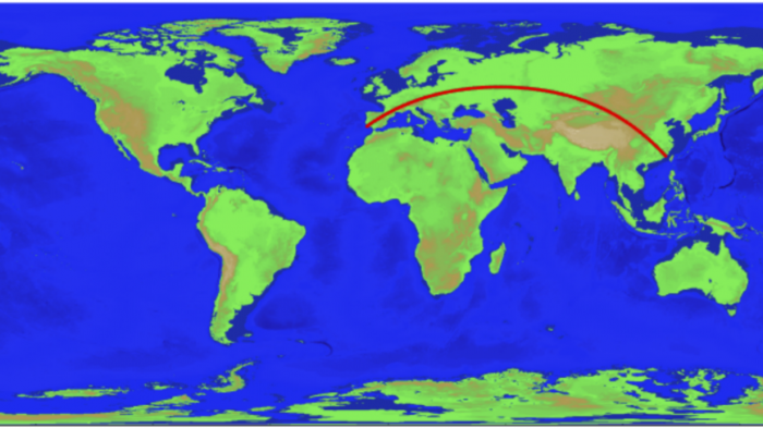
I did find something on the web that claims that an 11241 km route from China to Portugal is the winner.
Apr 24, 2020 10:54 PM
#
But this is a discussion of straight lines on orienteering maps. I doubt the great circle path is appropriate. Is there a global projection that ensures magnetic north is the same as grid north? My guess is it would be a very weird map.
Apr 25, 2020 12:45 AM
#
I was wondering if there was a parallel of latitude which went from the west coast of Africa to the east coast of Asia without crossing ocean, but there isn't quite (the northernmost point of the Persian Gulf is about 0.08 degrees of latitude (or 9km) north of the southernmost point of the Mediterranean along the Libyan coast).
Apr 25, 2020 1:52 AM
#
What about Dakar, Senegal to Da Nang, Vietnam? There are a few lakes that might be a problem, depending on exactly where you put the endpoints, but it seem to miss all the salt water. 13144 km. Likewise Monrovia, Liberia to Fuzhou, China, 13583 km. (Oh, you were looking for constant latutude, not great circle.)
Apr 25, 2020 8:40 PM
#
@TheInvisibleLog: I seem to remember that the English term for a line with a constant compass angle is a "Rhumb Line"?
You could look for such a curve starting in west Africa, crossing the Suez to get into Asia and ending somewhere in Russia or China?
You could look for such a curve starting in west Africa, crossing the Suez to get into Asia and ending somewhere in Russia or China?
Apr 25, 2020 9:00 PM
#
I just realized that a Mercator world map is what we need! (Regular O maps also use Mercator, but flipped, i.e. UTM.)
After locating such a world map it really looks like you can start in Guinea-Bissau, go across Africa and pass just south of Cairo and over the Suez. Next you'll go south of both the Caspian Sea and Lake Baikal before you end up somewhere close to the Bering Sea. Approximating the distance with a few great circle segments gets me to ~9500 km (+/- 500 km?)
After locating such a world map it really looks like you can start in Guinea-Bissau, go across Africa and pass just south of Cairo and over the Suez. Next you'll go south of both the Caspian Sea and Lake Baikal before you end up somewhere close to the Bering Sea. Approximating the distance with a few great circle segments gets me to ~9500 km (+/- 500 km?)
Apr 27, 2020 2:09 AM
#
Just to contribute further to the thread drift here, is anyone keeping records on the longest single leg in a 'typical' orienteering race? Let's say in a WOC long distance/classic just to try and standardise things. The infamous Leg 2 at Stromstad 2016 (M & W) stands out for me in recent years, as featured recently in World of O, but given the way the balance between route choice and detailed navigaton has shifted over the years I suspect there may have been some monster legs in the early days of the World Champs.
Apr 27, 2020 5:57 AM
#
The most famous WOC leg here in Norway is from the first WOC in Czechoslovakia 1972, when Stig Berge was expected to repeat his win from two years before, and he did in fact finish with a clear lead. Åge Hadler however came in and beat him by 5 min, a lot of it gained on a single leg where even in hindsight it was very hard to read the map closely enough to realize that Åge had found a route nobody else had seen, maybe even including the course setters.
I could not find the map with course but here's a sample which might help to show why the then-current mapping standard and analog map drawing conspired to make it hard to read:
http://omaps.worldofo.com/index.php?id=48392
I could not find the map with course but here's a sample which might help to show why the then-current mapping standard and analog map drawing conspired to make it hard to read:
http://omaps.worldofo.com/index.php?id=48392
Apr 27, 2020 10:49 AM
#
The longest leg on the Classic in 1993 was a little over 2 km. We would have liked to have made it longer, but it just wasn't practical. Much longer than than, in that terrain, and the route choices would tend to get too obvious, there would be some "around" route that would dominate. And the rest of the course would have suffered, because of the constraints on where such a long leg could begin and end, along with the logistical constraints of where we could locate the start and finish, the total amount of climb, the total course length, etc. It would have reduced the opportunity to use interesting terrain for the other legs.
Apr 29, 2020 7:18 PM
#
bubo:
Found the map from Czechoslovakia in 1972.
I´m sure I have map with route choice and results somewhere...
I´m sure I have map with route choice and results somewhere...
Apr 30, 2020 2:02 AM
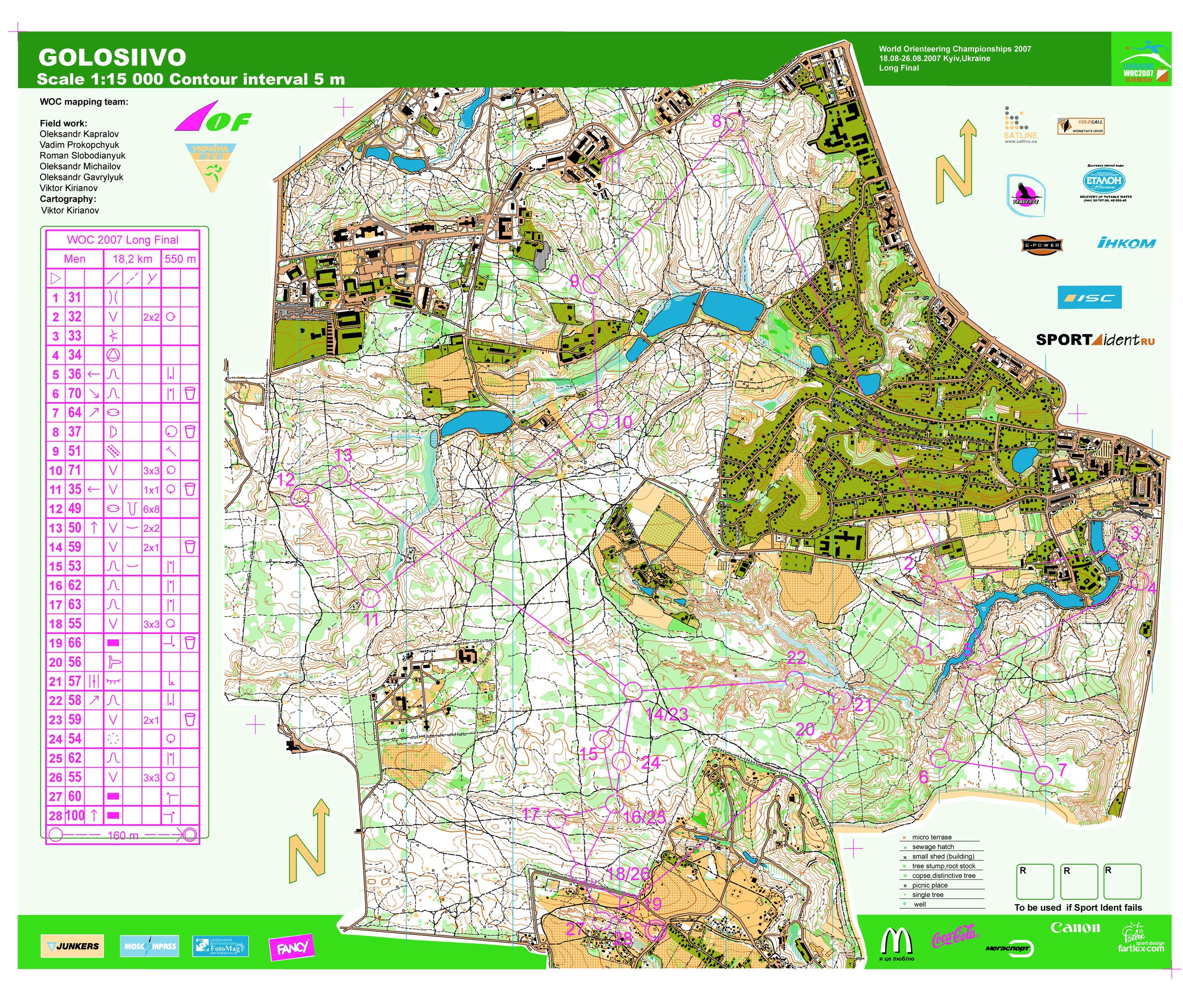
#
Yes, WOC2007 Long Final--where if you were able to finish, you deserved a medal. The locals' efforts to take down the Scandis finally bore fruit, as the amoeba, giardia, and ion-inundated refreshments finally overcame the prima donnas' weak constitutions, leaving the gastrointestinally-galvanized eastern Europeans to stand tall.
Apr 30, 2020 3:22 AM
#
Yes, 100F with humidity that day, and lack of A/C everywhere made it a killing field.
Apr 30, 2020 6:43 AM
#
@jjcote: Looking at the map I'm not sure. I would like to suggest 10-11 with most runners going relatively straight and Åge finding the long right loop which is nearly flat, and very little climb into the control, but that one seems too easy to find?
Apr 30, 2020 8:03 PM
#
bubo:
@jjcote In 1972 the decisive leg was 12-13 where Hadler (8 min) ran straight north from the control and then followed a meandering trail just north of the line. Stig Berge (11 min) ran south of the line - maybe it was hillier, it´s hard to see on the map.
Very few other runners had decent times there. Both Swiss men Dieter Wolf (6th) and Dieter Hulliger (4th) had 17 min being even with Berge before that leg.
Very few other runners had decent times there. Both Swiss men Dieter Wolf (6th) and Dieter Hulliger (4th) had 17 min being even with Berge before that leg.
May 1, 2020 1:47 AM
#
Regarding WOC 1972 @Terje: Age Hadler's route from 10 to 11 was probably found by many, me included, because during a significant part of the route we were going to run on the same trail in the opposite direction from what we did going from 6 to 7.
There were only three of the 18 legs where Hadler's and second place Stig Berg's routes differed significantly 2-3, 7-8 and 12-13.
I have spent 48 years since trying to find terrain as complex as the WOC 72 terrain. I hear WOC 85 in Australia came close.
There were only three of the 18 legs where Hadler's and second place Stig Berg's routes differed significantly 2-3, 7-8 and 12-13.
I have spent 48 years since trying to find terrain as complex as the WOC 72 terrain. I hear WOC 85 in Australia came close.
May 1, 2020 3:21 AM
#
For WOCs, I'd say 1993 and 2011, at least, are in the same ballpark as far as complexity goes.
May 1, 2020 3:10 PM
#
@bubo: Thanks a lot for posting those links, they are extremely typical for Sweden, i.e. showing just the winner and then the best Swede, instead of the top three which we would always do in Norway. :-)
I see that Åge was in the lead all the way, with sole lead from control 6 even though it is harder to determine since the control guards only noted the nearest minute.
I was in the same club as Åge for 26 years (Tyrving), he was extremely fit at least until he turned 60: We had an orienteering cup for 15-20 years, with each club scoring points in multiple courses from 2 to 6 km. One year we had one such event against 2 or 3 other clubs located at the bottom of a slalom hill where the 2km (young beginners) ran a course down on the flat area at the bottom while all other courses would first run up the hillside (in the forest), then have a loop on the very nice terrain on top, before returning to the finish.
Åge won the 3km (absolutely no surprise), but he did it by matching the speed (7 min/km?) of the best runners in the longer courses who didn't just run up and down again.
I found a more recent map of the area, the slalom hill is the obvious yellow patch:
http://tmsw.no/qr/show_map.php?user=terjem&map...
This discussion thread is closed.