Discussion: Dontgetlost Corn Maze 2017 Maps and Results
in: Orienteering; General
Sep 30, 2017 4:26 AM
#
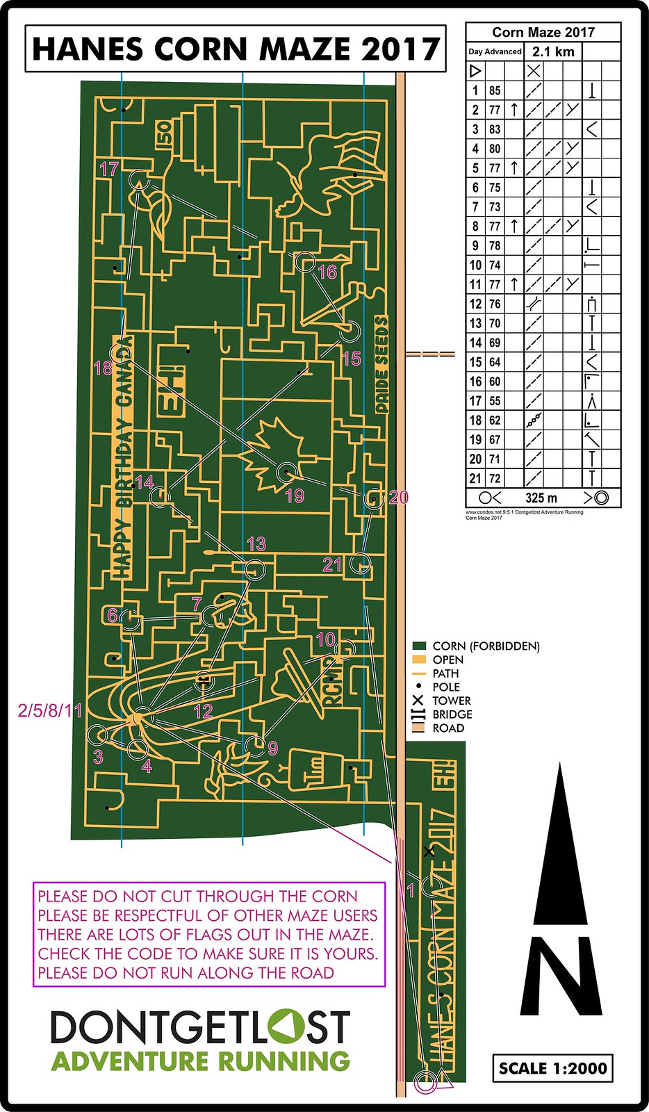
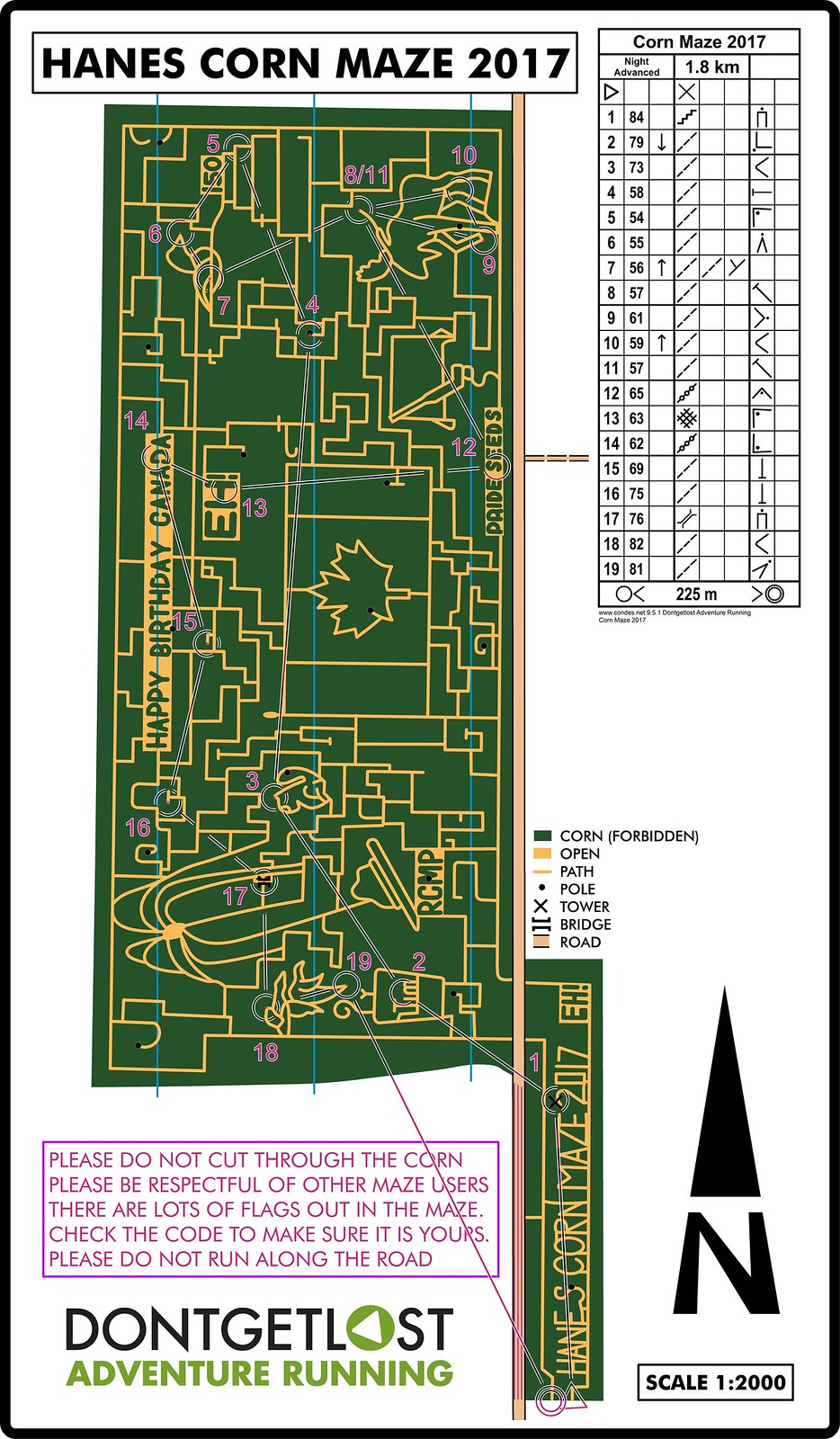
Another great (and an even bigger maze than in previous years) corn maze race at Hanes Corn Maze in Dundas. The maze is in between the middle and long distance areas for this year's Ontario Championships. If you are coming from out of town and would like to try it out let us know and we will get you a map (although the controls are no longer out).
Results

Results
Sep 30, 2017 5:58 AM
#
Your maze looks so much fun! Ours is coming up on Sunday.
It's also fun to see two different, yet valid, interpretations of mapping a corn maze to orienteering standards. You use impassable dark green and open yellow for paths. I use olive green, the path symbol for paths, and yellow for larger open areas (the last few years, there hasn't been any yellow within the maze, just for the group campfire areas cut in the corn surrounding the maze.
Anyway, I like your corn maze mapping style. Good job on the map and courses!
Sep 30, 2017 8:18 AM
#
Thanks Atropos for another amazing corn maze race! The corn was really high this year and the windy conditions made the experience that much more fun. Lots of tough route choices and running through the maple leaf on the flag felt like a slalom race. Great to see so many families out enjoying the corn maze fun.
Canadian flag, Timmies cup (it is Hamilton after all!), moose, canada geese, loon, hockey stick, fireworks, happy birthday eh, RCMP hat, and a beaver. Anything else?
Canadian flag, Timmies cup (it is Hamilton after all!), moose, canada geese, loon, hockey stick, fireworks, happy birthday eh, RCMP hat, and a beaver. Anything else?
Sep 30, 2017 11:56 AM
#
I think that the 150 by the loon is a birthday cake topper.
The mapping is an interesting question. I like the clean look of the yellow in the green but I have had to tweak it over the years. The first time I mapped a corn maze I used the darkest not forbidden green but there wasn't enough contrast and the map could be difficult to read especially during the night race. The darker green makes the maze really pop but can make the course difficult to see. I'm looking forward to seeing your map Pink Socks.
The mapping is an interesting question. I like the clean look of the yellow in the green but I have had to tweak it over the years. The first time I mapped a corn maze I used the darkest not forbidden green but there wasn't enough contrast and the map could be difficult to read especially during the night race. The darker green makes the maze really pop but can make the course difficult to see. I'm looking forward to seeing your map Pink Socks.
Sep 30, 2017 12:35 PM
#
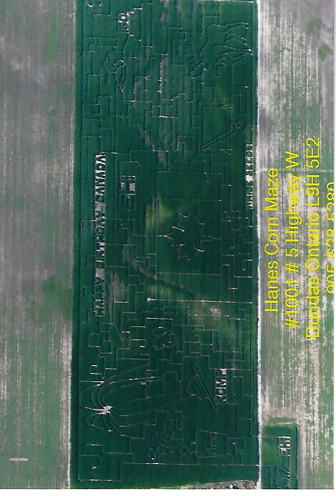
Colours aside. How do you get the details for the maze on to the map? I'm used to using Google Earth or Bing photos for my detail but of course the maze is done and gone before those photos would be uploaded. Do you use a drone to take photos? Does the farmer work from a plan that you can access?
And yes! An awesome maze with fun assured.
Has the farmer considered adding a permanent O to his maze?
And yes! An awesome maze with fun assured.
Has the farmer considered adding a permanent O to his maze?
Sep 30, 2017 1:37 PM
#
rm:
I understand that many mazes are created by a GPS guided harvester following a design made on a computer, often by a company that specializes in this. (Of course, it seems typical nowadays for harvesters to be GPS guided.). So, the farm may have a file containing the design. A farm in Colorado provides a map to all maze visitors, including several controls with ticket punches, which is the map RMOC uses unmodified.
Sep 30, 2017 11:20 PM
#
We are lucky that the farmers actually take an aerial photo of the maze each season and have some photo prints available. It is always interesting to see which parts of the maze which were originally cut didn't end up in the final maze. Specifically, one of the (very fun looking) moose antlers completely disappeared.
This discussion thread is closed.