Discussion: Creating contour maps from Google Earth??
in: Orienteering; General
Sep 27, 2017 9:48 AM
#
Has anyone here ever tried or do you know anything about this method of creating a contour map from information obtained from Google Earth?
Having worked one summer as the rod man on a survey team the method seems familiar and reasonable however the end result in the demo looked suspiciously good and there is an expensive piece of software (ArcGIS or Surfer) required to complete the process.
Thanks for your advice.
Having worked one summer as the rod man on a survey team the method seems familiar and reasonable however the end result in the demo looked suspiciously good and there is an expensive piece of software (ArcGIS or Surfer) required to complete the process.
Thanks for your advice.
Sep 27, 2017 11:14 AM
#
For orienteering purposes, e.g. creating a basemap, I can think of a couple of reasons why that technnique is not going to work out very well.
Sep 27, 2017 11:25 AM
#
jjc. Would you care to share one of two of those reasons?
But to be clear my need is not to create a base map. I can always gt that from Open Street Map and a variety of orthophoto or aerial photo sources. The need is for contour detail.
But to be clear my need is not to create a base map. I can always gt that from Open Street Map and a variety of orthophoto or aerial photo sources. The need is for contour detail.
Sep 27, 2017 1:03 PM
#
Very low resolution, poor detail. What is the source of elevation data? I'll bet the data source is something low res like SRTM. Poor contours could be worse than no contours.
Sep 27, 2017 1:28 PM
#
rm:
Ron Birks of GPHXO has used digital elevation models from government sources to produce 5m contours for orienteering/rogaining events at Petrified Forest National Park. The low resolution of the data made the quality of contours variable, but he produced something that's been used for a few fairly popular events. The usefulness of such an approach may depend on your intent. I think that it'd be worth trying to get the full DEM though, not just a few points here and there as in this method.
Sep 27, 2017 1:55 PM
#
Thanks Jim. I actually plotted with points about 20 m apart which I thought would not be near enough but it was just a trial.
Things went well until I came to using ArcGIS or Surfer to output the final product. I downloaded the demo of Surfer and it only outputted for me a small snip of a map and the contours look too good to have come reliably from the input, way too good. The demo had very smooth contour lines with 2 m interval.
So my question now is does anyone here have ArcGIS or Surfer? If so may I send to you a file with 860 elevation points which you can then put in to contour line form and send back? (No Aussies, in this case Surfer has nothing to do with the ocean.)
Sep 27, 2017 1:57 PM
#
It is actually amazingly good if you live in a country that either gives you no access to any contours whatsoever because of National safety or something (Singapore, may have changed since a non-expat has embraced orienteering and spearheading the efforts), or the place is more rural and does not have the abundance of readily available, often upgraded 2 m contours for the capital or other major city, contours you can trace in by hand (Taiwan, abundant data for the big city areas, accessible at a city government office, available as TIFF files - may have also improved a lot since we lived there; they even had some Lidar data somewhere, at universities, tried very hard to get a hold of some, not successful). And trying to map them manually (had not done that since I was 15 helping our coach, and steep learning curve) was not a good option when the map will ultimately be a network of trails in 408 vegetation if lucky, but usually 410. Also too scared of snakes and huge spiders...
Sep 27, 2017 3:30 PM
#
Gordhun - you can use QGIS to do it.
The way I did mine, but there's probably easier ways:
* Save your data in XYZ format - so [x-coord] [y-coord] [altitude] (space between each element, one row per line)
* QGIS should open that as a raster image
* Raster -> Extraction -> Contour, select interval and output, probably as DXF if you want to drag it into OCAD.
Email in my profile if you get stuck and want to send it across. :)
Sep 30, 2017 3:39 PM
#
For anyone still following this thread, gordhun and I have got a rough process worked out.
- Generate your list of coordinates to get heights for. I used Excel, because the original link's method of using Google Earth is silly, but whatever way you go you want to end up with a list of coordinates, one per line, in the form
[lat],[lon]
[lat],[lon] - Retrieve elevations for the coordinates. I dropped them into this page, entered a Google Maps API key (which I already had, but they're free) and left it overnight because I was doing 160,000 points.
- Saved the result out as a CSV file
- Used QGIS to convert the result into a shapefile (Layer -> Add Layer -> Delimited Text Layer), then save as shapefile
- Used SAGA to do a 'Multilevel B-Spline interpolation’ (no, I don’t know what that means either) to get a smooth-ish surface, and saved as TIFF file
- Back into QGIS and generated contours (Raster -> Extraction -> Contour), although SAGA can probably do this better.
Sep 30, 2017 7:45 PM
#
A coupe of questions for you Juffy,
Your 160,000 points. That's for how large an area? Or really what I'm asking point spacing / density is that?
What is the quality of the final data? I'm guessing this depends on the area you're doing based on the data Google has access to. I know in many cities Google seems to have access to high quality Lidar that they are using to show 3d buildings trees in Google Maps. Perhaps this is a cheap but more intensive way of getting access to that data which can sometimes cost $150 + /sq km...
Oct 1, 2017 7:11 AM
#
Sorry, 16,000 points - 160x100 at 10m spacing, so an area of 1.6x1.0km. At the end of the day the point count is only relevant in how long it takes to retrieve the elevations.
Here's the output:
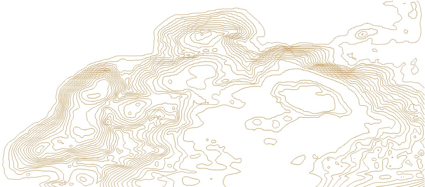
You can see a little bit of jaggedness, which I think is an artifact of the SAGA interpolation step and possibly the gridded nature of the original points - QGIS has similar functions but using worse algorithms, and produced very jagged output. Maybe you'd get better output with a semi-random scatter pattern of points?
Won't really know the accuracy/detail level until someone (presumably gordhun :) ) goes out and compares it to the ground.
Here's the output:
You can see a little bit of jaggedness, which I think is an artifact of the SAGA interpolation step and possibly the gridded nature of the original points - QGIS has similar functions but using worse algorithms, and produced very jagged output. Maybe you'd get better output with a semi-random scatter pattern of points?
Won't really know the accuracy/detail level until someone (presumably gordhun :) ) goes out and compares it to the ground.
Oct 1, 2017 12:20 PM
#
What is the source of the elevation data? Google is not flying is own Lidar missions, so the data must have come from some other source. That other source is most likely in a more accessible form.
Oct 1, 2017 12:54 PM
#
I would say their source of last resort is the ASTER (or whatever) 30/90m satellite datasets, but if google has better data available they'll use it.
Jim - 3m, because apparently Canadians are weird. :)
Jim - 3m, because apparently Canadians are weird. :)
Oct 1, 2017 5:34 PM
#
I'll be taking a look at the area this coming week. I'm in Ottawa Canada and this area is in Thunder Bay. We are in the same province but 2 1/2 flying hours (through Toronto) apart. I only got interested in planting an orienteering seed there because my son and his family now live there.
And the Canadian O-Store was able to direct me to a great contact who had learned his orienteering in Waterloo (Nick Duca) and DGL adventure races (Hammer).
Turns out this XC ski club was just starting a youth adventure / orienteering program similar to ARK and would like a good map to do ski orienteering in the winter. The city has provided good and free LiDAR information for parks within the city but their club grounds are outside the city.
Hence the scramble to find something better than the 10 metre contour interval the province provides.
I'll be interested to see how this base map turns out. It seems to match well with the Google Earth images and the map I started from Open Street Map.
Stay tuned.
Oct 1, 2017 6:38 PM
#
I agree GE likely chooses from whatever is available with or without restrictions. Perhaps a comparison with the contours generated from GE elevations can be made using one of these sources:
1. A commenter in the original video said the GE elevations could be downloaded at http://srtm.csi.cgiar.org/ It's 90m resolution though. Perhaps that would be used when nothing else is available.
2. Canadian elevation data is available from http://ftp.geogratis.gc.ca/pub/nrcan_rncan/elevati... I've used these ocassionaly but they are based on 1:50000 mapsheets so not really of much use for large scale mapping. Perhaps GE would use these for Canada where higher resolution isn't is available?
Ontario's Data https://www.ontario.ca/data/provincial-digital-ele... I didn't see where do download it so am not sure if it's publicly available though it seems it should be. Most Ontario universities seem to have it, but with restrictions https://library.mcmaster.ca/maps/geospatial/provin...
In BC, GE seems to be acessing provincial government photos which aren't publicly available, so they may have access to restricted elevation data as well. In other provinces map data, including some LiDAR is freely available.
Oct 1, 2017 7:22 PM
#
Bryan You can see the area and judge the elevations for yourself by searching Lappe Ski Centre on Google Earth.
One additional observation is that along the W side of the map it seems likely that some contour lines did not carry forward to the final product.
One additional observation is that along the W side of the map it seems likely that some contour lines did not carry forward to the final product.
Oct 1, 2017 8:11 PM
#
Thanks Gord. I'll check and see what I can find for the area when I have a chance. Getting ready to head off and take advantage of some nice October mapping weather heading our way this week.
Oct 2, 2017 4:09 AM
#
I've had really good luck walking into (+ calling + emailing as well) government GIS offices and asking for lidar data. If they want to charge you money, first use the "We're a non-profit" line. If that doesn't work, say that's it's likely to drive some amount of tourism to the park/forest/whatever. If that doesn't work, ask, "Who could approve giving [you] the data for free?" If that doesn't work, ask if there are other organizations that funded the lidar and received it; and how could you contact those other organizations?
This discussion thread is closed.