Discussion: route choice - passing 100% green vs large detour?
in: Orienteering; General
Mar 13, 2017 7:12 AM
#
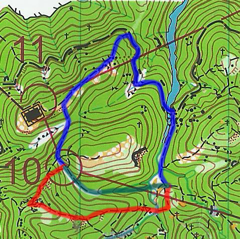
In the process of entering 10 in the following map, would you choose to follow the green forest route rather than going through the alternative routes, with involves considerable amount of extra distance or climb? (the majority of green is 100% green)
Mar 13, 2017 7:47 AM
#
It seems that the green forest route is in reentrant where the green would be almost impenetrable. The red alternative is a trail with more distance and climb. I might try to head for the cliff at the east edge of the light green area, find the scattered trees near the top of the hill, then follow the trail to number 10.
Mar 13, 2017 9:38 AM
#
I think I might try taking left one (red route) and look right when climbing up. When/if I see less bad spot in vegetation about at halfway up I'd turn right and go down those two contours though green to the path at the bottom. If vegetation is genuinely impossible I'd go around - or go home.
Mar 13, 2017 9:57 AM
#
bubo:
Definitely NOT go through any green forest!
The red route seems reasonable and involves only little more climb than the much longer blue route.
Reminds me of my only visit to HongKong many years ago when I tried to make a short-cut through dark green and was left hanging in thorny bushes without feeling the ground with my feet. It´s a funny memory today but not so fun when it happened ;)
Mar 13, 2017 10:31 AM
#
I did something similar in Ballarat blackberry bushes back in 2015. They told us at the start to avoid the dark green but on the third loop of a three loop race, I decided it didn't look too far so attempted it and regretted it immediately.
I can't really tell what's what in the above map. To me it looks like there's a dashed line all the way under the lighter blue route.
I can't really tell what's what in the above map. To me it looks like there's a dashed line all the way under the lighter blue route.
Mar 13, 2017 11:14 AM
#
rm:
Well, according to ISOM, it's worth going at least five times as far around as through. So, if they have trails in them (hard to read), then blue right and red left should beat blue left (if the latter includes running up a stream in dark green a couple hundred meters), even accounting for the extra climb at five meters of running for one meter of climb. Or at least it looks like that without measuring. Dark green is intended to represent pretty awful vegetation.
Mar 13, 2017 11:24 AM
#
rm:
Of course, it's possible that one will find an unmapped gap in the dark green, and save a lot of time that way. A bit of a gamble. I'm curious how they found that gravestone in the midst of the dark green. Last known location of one of the mappers?
Mar 13, 2017 11:42 AM
#
Just the one grave? I count at least eight on that map. I can only imagine it was people looking for different routes through the green.
Mar 13, 2017 11:49 AM
#
I think that since this is control #10 the situation will in fact be quite obvious:
If the green is in fact dark green bordering on impassable, then going left is the only good choice, with Jagge's suggestion to look down & right a good idea.
If the dark green is in fact 20% runnable, then cutting downhill will only be 2-3 times slower than going up the path, so this will be the best route.
Mar 13, 2017 12:34 PM
#
Depends though, I thought the blackberries would be passable until I got stuck in them.
Mar 13, 2017 12:44 PM
#
Every time I've tried to pass through dark green, I've regretted it. Yes, once or twice I even thought "They'll never think to look for my body in here."

Mar 14, 2017 1:28 AM
#
A contingent of HK orienteers came to our Xmas 5 day event just recently. They enjoyed themselves and did extra training as well as the 5 events on offer. Their results showed improvement over the carnival as they came to terms with our terrain. At the end they presented a set of current maps and asked for any mappers. Surprisingly none accepted the generous offer.
Mar 14, 2017 9:18 PM
#
Was all excited to write a "grave sites represent failed routes" quip. Hopes were dashed when I saw no less than four had already beaten me to it.
This discussion thread is closed.