Discussion: Course design - Harvest Coffin Long F21
in: Orienteering; General
Apr 13, 2016 2:15 PM
#
rm:
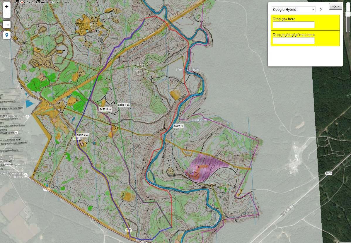
Here is Harvest Coffin's design of a Long F21 course at Otter Creek, for your insights.
Apr 13, 2016 3:46 PM
#
On the whole the course looks good. Despite the fact that there is only one long leg, I really appreciate the effort to make it extra long. Unfortunately, in this case, it doesn't quite work because of the nature of the terrain - by extending the leg over more reentrants and ridges the straighter route no longer makes sense and the route along the river has you swinging back and forth across the line to many times so it becomes too long to be viable. That leaves the basically flat route to the right. There are multiple ways to do this right route but, nonetheless, what seems at first glance to be a great route choice leg is, in fact, a mediocre long navigation leg. You would be better off splitting that leg in two to get better route choice on both.
Going through the rest of the course bit by bit:
Nice first leg. I would move the control down the slope a ways to make the second leg stronger (improve the route choice). This also adds an extra level of complexity to the first leg.
Legs 3 - 7 are very nice but I think you could play with changing the tempo a little bit more. Add a nice short leg into two where you have very technical terrain to make the fast leg to 3 a more dramatic change. Similarly, at 6 I would adjust the control location so there is a sharper change in direction to make the flow through that control harder and force athletes to pay a little more attention as they exit the control.
8-11. Love this loop. Especially after the big long leg. It's a great change in pace and technique in the greener forest. Only thing is putting control 8 right at the top of the hill. If you move it SW (say to the boulder) you remove the climb and immediate descent and add a bit of route choice to 9.
11-end looks fine but nothing special. All the legs are of similar length through similar terrain. Specifically though, I don't like that you cross the road so many times so close together. Everytime you cross the road like that you can just run on an easy bearing out of the control to the road so the leg becomes that much easier (though running blindly to the road is still not the best technique ;) ). Move control 12 to the east side of the road (maybe to the south west end of the ditch south and slightly to the right of 13?).
As I said, on the whole it looks good - just some small adjustments to improve certain sections and rethinking the long leg.
Apr 13, 2016 4:49 PM
#
#1: If the green is visually dense along the road, then it becomes very tempting to run wide right, so for this to be a good leg, mor or less straight has to be significantly faster, right?
#2 is a left bend, the orienteering consists of balancing the amount of climb with the extra distance, then you hit the path.
#3 is mostly transport, going left or right of the fenced area is approximately equal in time and difficulty.
#4 is really transport along the creek which becomes the dry ditch.
#5 is also below championship level difficulty.
I agree with Candian that the long leg to #8 looks great at first glance but the low route doesn't quite work out: By moving #7 a bit lower, maybe near the '7' digit, and then #8 closer to where #10 is, the low and high route becomes visually more equal.
I also agree that the 3 final road crossings should have been avoided.
Apr 14, 2016 12:49 AM
#
AZ:
I kind of think it might be okay. It is actually very difficult to assess the route choices without being able to measure. If I was the course planner for this I would have measured each route and used a handy table I have that compares speed in various types of terrain.
But even if the bottom route turned out to be a viable option I'd still not be happy for a couple of reasons. In one case it seems like a "trick" route - its a bit bizarre to take that route. But mostly because I don't think it is cool that a good route choice involves running on a track for almost 2km (or whatever it is) - that's just not what people are looking for (IMO).
But even if the bottom route turned out to be a viable option I'd still not be happy for a couple of reasons. In one case it seems like a "trick" route - its a bit bizarre to take that route. But mostly because I don't think it is cool that a good route choice involves running on a track for almost 2km (or whatever it is) - that's just not what people are looking for (IMO).
Apr 14, 2016 6:43 AM
#
ndobbs, +1. I was about to ask the same but then remembered I know nothing about this terrain type.
Apr 14, 2016 12:03 PM
#
Re river route: As I wrote above it doesn't look feasible as-is, but since it occurs relatively late in the oure the competitors have enough knowledge about running speed in the various terrain types to be able to evaluate it properly:
If it then turns out to be a win, either in pure time spent and/or in energy saved due to being very flat, then it is an interesting leg indeed. :-)
It reminds me of the huge leg in Blodslitet D21E a couple of years ago, where the first articles claimed that the eventual winner won due to taking a very long detour on roads and paths, but in reality it was equal in speed to a well-executed direct line:
http://www.tulospalvelu.fi/gps/20141018D21siste/?v...
The fun part starts at 12:02:30 when BABN (Betty Ann Bjerkreim Nilsen) visits the first control, followed a few minutes later by KO and then AMNH (Anne Margrethe Nordberg Hausken).
It is also well worth noting that Betty Ann (and her sister) is well known for road/path running strength while Anne Margrethe is better at crossing difficult terrain at speed, so it is likely that they would both have lost time by taking the other's route.
Apr 15, 2016 11:53 AM
#
Thanks Jagge!
The flat river route is exactly 100 m longer than the medium right bend, with the most complicated option a couple of hundred meter shorter, this means that all these route choices are quite valid and it makes it probably the best long leg we've seen on this map. :-)
The flat river route is exactly 100 m longer than the medium right bend, with the most complicated option a couple of hundred meter shorter, this means that all these route choices are quite valid and it makes it probably the best long leg we've seen on this map. :-)
Apr 15, 2016 2:55 PM
#
Well - obviously I'm wrong. Not only is it a feasible route but it's quite possible the best route and I completely dismissed it which makes it a great route choice leg. Well done!
Apr 15, 2016 3:07 PM
#
AZ:
Well, while I think the route choice is interesting I don't think that is enough to make this a "Good Leg" - it takes more than route choice to make a good leg. In this case the best route is probably to run more than 3km along a trail with very basic navigation, so the leg leaves out a crucial part of the nature of the sport. So I give this leg "interesting" status, but wouldn't be happy with it as a controller of a major event since it will eat up a lot of the Recommended winning time (15 - 20 minutes perhaps) with very little navigation.
.
From the IOF Rule book....
Course planner’s golden rules
The course planner must keep the following principles in mind:
• the unique character of foot orienteering as running navigation
• the fairness of the competition
• competitor enjoyment
• the protection of wildlife and the environment
• the needs of the media and spectators
2.3.1 Unique character
Every sport has its own character. The unique character of orienteering is to
find and follow the best route through unknown terrain against the clock.
This demands orienteering skills: accurate map reading, route choice
evaluation, compass handling, concentration under stress, quick decision
making, running in natural terrain, etc.
Apr 15, 2016 5:58 PM
#
rm:
But notice the course design guidelines regarding Long, and its differences from Middle and Sprint:
"The Long distance profile is physical endurance. It [...] aims at testing the athletes’ ability to make efficient route choices, to read and interpret the map and plan the race for endurance during a long and physically demanding exercise. The format
emphasises route choices and navigation in rough, demanding terrain, preferably hilly. The control is the end-point of a long leg with demanding route choice, and is not necessarily in itself difficult to find. The Long distance may in parts include elements characteristic of the Middle distance with the course suddenly breaking the pattern of route choice orienteering to introduce a section with more technically
demanding legs."
A few km of trail running is a lot, but it isn't as far from the character of the race as it would be in Middle. Plus, the first third actually requires a bunch of map reading to be efficient and follow the correct linear feature. The next third has a lot of running along a narrow trail at the base of a steep hillside and just above a river...often those can be physically demanding and also require care not to end up off on a spur amongst the inevitable braiding, and avoiding bits of trail that have washed out and been bypassed. The last bit requires some care to jump between trails at the right places and not do boneheaded things like running parallel to the trail one's seeking, or such. Granted, this is less navigation at a much higher pace, but with some consequence. I generally prefer long legs with more navigation, but for a Long, I think that probably it counts as "good", and it's better to include this leg as a challenge rather than to provide a course that's entirely a lenghty Middle, or even a course with a max leg length of 1.5km. Feel free to disagree with me on this point, but I think that it's key to the character of Long, and in many cases missing.
Apr 16, 2016 1:56 AM
#
AZ:
Jim - you trouble maker ;-) I don't buy your story. This leg has good route choice but misses so many other characteristics of a good orienteering leg that I can't bring myself to give it "good" status. The navigation (on all routes) is almost trivial (at least for a US Champs contender), the demand on concentration and decision making is minimal. A few courses have been accused of being "nice but very long middle distance" - I think this might be an instance of a "nice but extremely long sprint distance course" ;-) - route choice is fabulous, but navigation is simple. Gotta say - I sure miss having you out in Western Canada for more of these debates in person ;-)
Apr 16, 2016 3:01 AM
#
rm:
Yes, those chats were fun.
One takeaway might be how few such truly long legs we have here in North American orienteering. I may have gone entire years, not just entire Long courses, without one. I think it would be good if it became the norm for Longs, at the very least at national and North American championships, to have one, or better yet two. (Is it reasonable to expect an M21 Long to have at least one 4km leg, and an F21 Long to have at least one 3km leg?)
One takeaway might be how few such truly long legs we have here in North American orienteering. I may have gone entire years, not just entire Long courses, without one. I think it would be good if it became the norm for Longs, at the very least at national and North American championships, to have one, or better yet two. (Is it reasonable to expect an M21 Long to have at least one 4km leg, and an F21 Long to have at least one 3km leg?)
Apr 16, 2016 3:55 AM
#
I'll be blunt Jim - no it is not reasonable to expect legs of that length. The longest long leg I can recall seeing on the international scene in recent years is the ~3km leg from the Long Distance at the World Cup in Tasmania in 2015.
I see several downsides to that kind of super long leg:
1. The longer a leg is the more likely you are to find a valid trail or road running solution to it.
2. The longer a leg is the greater a percentage of the course it takes up which leaves less room to do other interesting stuff with the rest of the course.
3. The longer a leg is the more likely it is to be the overwhelming decisive factor in the results of the course. The problem with that is that it disproportionately weights the importance of that single decision point and makes it no fun for competitors that realize part way through they've made a mistake.
On the whole, I'd much rather see three 1-1.5km long legs than a single 4km long leg.
Apr 16, 2016 4:33 AM
#
rm:
I believe that leg is about 4km. It does indeed take up a large fraction of the course, and has an outsize impact on one's result. But, isn't that the point in a Long?
A 1.5km is quite different in character. All viable routes are likely within a couple of soccer fields (football pitches) of the straight line. The difference in routes is seconds to tens of seconds, hardly worth thinking long about. Look at the 4 km leg you linked to. The routes may differ by quite a bit in time, and there are several, of various character. It is a very hard decision, and one must commit. Personally, I think it's a fun challenge (and one that our M21s and F21s will encounter at World Cups, World Champs, even WUOC, as I did).
A 1.5km is quite different in character. All viable routes are likely within a couple of soccer fields (football pitches) of the straight line. The difference in routes is seconds to tens of seconds, hardly worth thinking long about. Look at the 4 km leg you linked to. The routes may differ by quite a bit in time, and there are several, of various character. It is a very hard decision, and one must commit. Personally, I think it's a fun challenge (and one that our M21s and F21s will encounter at World Cups, World Champs, even WUOC, as I did).
Apr 16, 2016 11:57 AM
#
A guideline that I attribute to Dave Linthicum is that no leg should account for more than 1/3 of the total length of a course, so that it doesn't overwhelm the course results..I never saw reference to this anywhere else, but I think this is a good guideline for Long/Classic courses.
Having said that, I think it is worthwhile to encourage the practice of studying a given map long enough to find the longest good leg possible, which often can go across the map. It is usually possible to apply this leg to the Red/F21E and Blue/M21E courses.
Compliments to some of the course setters here that seem to have found that leg, with slight variations, albeit with some reasonable debate about the quality of the leg.
Apr 17, 2016 1:44 PM
#
rm:
As an aside, setting a leg longer than a third of the course would actually be pretty hard to do, at least if the start is at all near the finish. For a Goat comprised of three loops of 5 km each, the best I could do was 1.7 to 1.8km long leg each loop. For a 15km course (a typical Blue near here, given the open terrain), a third would be 5km, rather long to set on nearly any North American ISOM map that I know of. So, I think that course setters are likely free to set the longest interesting leg that they can, with not much worry of exceeding the Linthicum limit. :-)
As a further aside, I wonder whether Long and Classic are the same format, or in fact quite different? Classic seems almost to be a hybrid of Middle and Long, before the two took on distinct identities. Long emphasizes endurance, physical terrain, route choice on long legs interspersed with some short legs, while Classic is more about moderate terrain, legs up to 1.5km, a more even pace. Perhaps some of the submitted courses are more like a Classic course, and others more like a Long? Just a thought I'm throwing out there.
As a further aside, I wonder whether Long and Classic are the same format, or in fact quite different? Classic seems almost to be a hybrid of Middle and Long, before the two took on distinct identities. Long emphasizes endurance, physical terrain, route choice on long legs interspersed with some short legs, while Classic is more about moderate terrain, legs up to 1.5km, a more even pace. Perhaps some of the submitted courses are more like a Classic course, and others more like a Long? Just a thought I'm throwing out there.
Apr 18, 2016 5:59 AM
#
Surely the optimum length of a long leg depends upon the terrain. The WC in Tasmania was a relatively untracked area. What works there would not work on a map covered by tracks. This is the reason I value undisturbed forest and grind my teeth at track making. You can follow the dots on that one.
Apr 18, 2016 12:43 PM
#
rm:
I've seen WOC courses in which the routes on the long legs used tracks a fair bit. It does depend a bit on terrain, but I think that one can set long legs on quite a bit of terrain. One could also possibly think that terrain suitable for Long permits long route choice legs. (But there's some disagreement on the topic, as you've seen. )
Apr 18, 2016 1:18 PM
#
Wasn't there a semi-recent champs where AliC (and another? brain fuzzy....) ran wide left and trailed just about the entire long leg, with a competitive split compared? You can imagine that "trail Ali fast woc" isn't yielding the results I want....
Apr 18, 2016 3:42 PM
#
Thank you, carlch.
Map:
http://www.woc2013.fi/wp-content/uploads/2014/08/L...
Leg is 10-11.
Splits:
https://www.attackpoint.org/racesplits.jsp/race_12...
GPS tracks:
http://www.tulospalvelu.fi/gps/2013WOCLongW/?v=m3
Map:
http://www.woc2013.fi/wp-content/uploads/2014/08/L...
Leg is 10-11.
Splits:
https://www.attackpoint.org/racesplits.jsp/race_12...
GPS tracks:
http://www.tulospalvelu.fi/gps/2013WOCLongW/?v=m3
This discussion thread is closed.