Training Log Archive: dlevineIn the 30 days ending Sep 30, 2019:
| ||||||||||||||||||||||||||||||||||||||||||||||||||||||||||||||||||||||||||||||||||||||||||||||||||||||||||||||||||||||
| « | » |
| » now | ||||||||||||||||||||||||||||||||||||||||||||||||||||
| Su | Mo | Tu | We | Th | Fr | Sa | Su | Mo | Tu | We | Th | Fr | Sa | Su | Mo | Tu | We | Th | Fr | Sa | Su | Mo | Tu | We | Th | Fr | Sa | Su | Mo | ||||||||||||||||||||||||||
Saturday Sep 28, 2019 #
Watching A Play 2:06:14 [1] 2.37 mi (53:16 / mi) +111m 46:30 / mi
ahr:81 max:133
Yup! "Arts in the Open" was putting on a play - I forget the title, but it was a 'paranormal mystery' - at the Chattauqua Institute in Boulder, CO. We got to hike, sit and watch a scene or two, and then repeat the entire endeavor. In the model of a "Choose Your Own Adventure" book, we got to vote on what scenes might or might not come next. I don't think that affected where we hiked, but I have certainly never covered 2+ miles while watching a play before!
Friday Sep 27, 2019 #
Biking 1:03:00 [2] 9.3 mi (6:46 / mi)
Thursday Sep 26, 2019 #
Note

...while this one (Grand Teton, I think) is from further down the highway...

We eventually made it back to Jenny Lake, but couldn't take the time for a hike as we had "miles to go before we [slept]"

Wednesday Sep 25, 2019 #
Walking/Hiking 1:58:06 [1] 2.91 mi (40:35 / mi) +23m 39:37 / mi
ahr:79 max:117
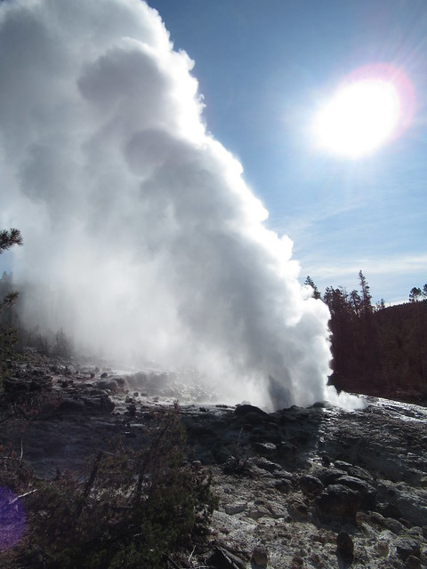
Normally, an after eruption is smaller than this and lasts only about twenty minutes, but this one continued for almost two hours. (We were told that's unheard of.) Word got out and the area was being swarmed with folks - mostly too late - as we were moving to the other basin.
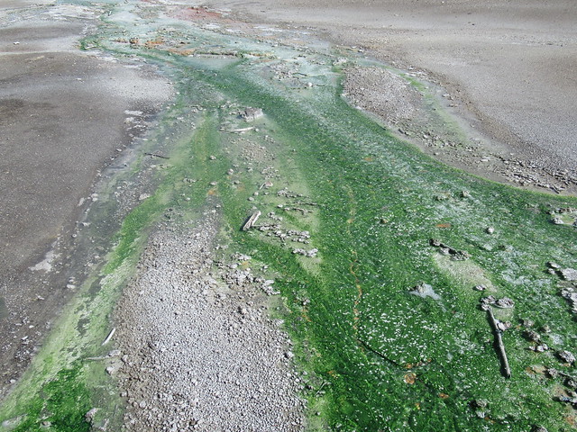
The thermophilic bacteria-filled creeks here were chromatically impressive and we enjoyed them and the general view of Porcelain Basin.

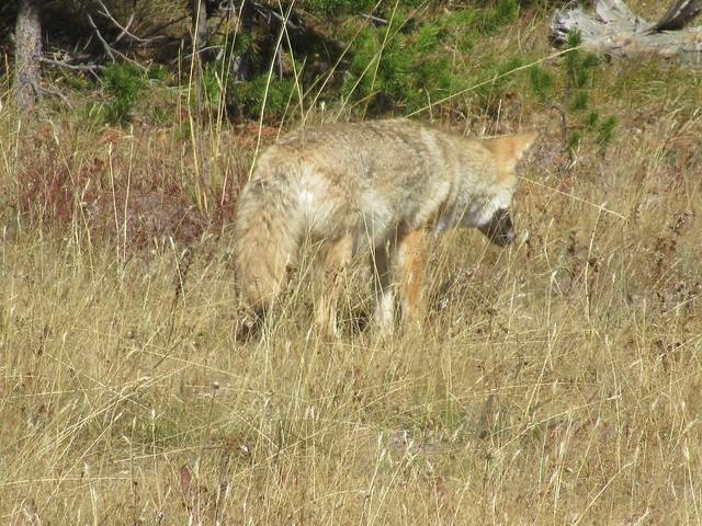
As we drove off, we saw this guy from the road.
We continued off to Yellowstone Canyon to get the photo below from Artists Point so that Theresa would have a match to a quilting pattern she had picked up in town. Very easy hike (150 yarrds) and completely wheelchair accessible. Virtually everyone who goes here gets the same shot, but it is a beautiful one.

Orienteering 40:47 [3] 1.1 mi (36:57 / mi) +31m 34:02 / mi
ahr:87 max:137
Tuesday Sep 24, 2019 #
Walking/Hiking 1:05:00 [3] 1.6 mi (40:37 / mi) +260m 27:00 / mi
Down to the falls and then back up. Also drove along the northern rim and visited about four other lookouts. Great views, but no photos worth sharing...
Walking/Hiking 34:11 [1] 0.84 mi (40:41 / mi) +52m 34:06 / mi
ahr:75 max:138

On the way out, we saw a bunch of photographers and were able to see what they saw, too...

Walking/Hiking 25:25 [1] 0.76 mi (33:27 / mi)
ahr:79 max:103
Monday Sep 23, 2019 #
Walking/Hiking 44:45 [1] 1.71 mi (26:10 / mi) +64m 23:26 / mi
ahr:85 max:118
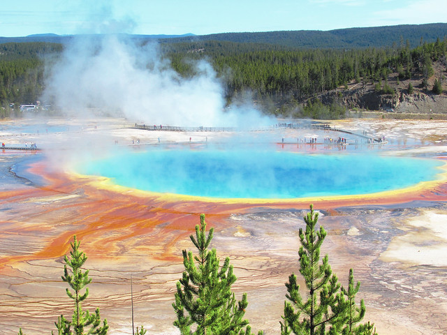
We had driven in to see the Great Prismatic Spring. We had the expected crowds, but hadn't planned on the cold weather causing so much fog that we could barely appreciate the pools. From the side, however, we did see a cluster of folks on an opposing hillside who seemed to have a great view. We went back to the car, drove down the highway and took a very leisurely hike back to the area where a side trail led to a great lookout.
Walking/Hiking 45:56 [1] 2.37 mi (19:23 / mi) +16m 18:59 / mi
ahr:68 max:131

Walking/Hiking 1:00:07 [1] 2.45 mi (24:32 / mi)
ahr:81 max:113
Walking/Hiking 1:03:47 [1] 1.57 mi (40:37 / mi)
ahr:85 max:118

We continued on the boardwalk and were getting ready to head back when we saw a crowd about sixty meters away sitting/staring at a mound of earth. We inquired and found that Grand Geyser was to go off soon. Sure enough, ten minutes later it went off, giving quite a show.

On the day, we saw four geysers go off with a total wait of less than forty minutes. With that kind of luck, we should have been buying lottery tickets...
Sunday Sep 22, 2019 #
Walking/Hiking 3:34:48 [1] 7.31 mi (29:23 / mi) +483m 24:23 / mi
ahr:102 max:142

There was rime ice and lots of cold fog as we climbed. We also saw bear tracks heading down the mountain. (That means the bear is behind us and going in the other direction, right?)

The top of the mountain used to feature a fire lookout, complete with indoor protection. The building is still there even though the functionality is now that of a cell phone tower. After a fogged in stay at the summit, we descended. Views got better on the way down.

...including our first views of Yellowstone Canyon.

We saw only ten folks on the way up, but several dozen were heading up as we headed down. They got better views, but we got a "winter hike" in at the very beginning of fall.
Walking/Hiking 7:01 [1] 0.21 mi (33:25 / mi) +21m 25:28 / mi
ahr:88 max:98

Saturday Sep 21, 2019 #
Walking/Hiking 2:04:12 [1] 2.51 mi (49:29 / mi) +108m 43:40 / mi
ahr:77 max:110
As is often the case in Yellowstone, parking was at a premium. We were lucky enough to get a good spot at the visitor center and decided not to risk the "full parking lots" further up. So, we grabbed our picnic lunches and hiked up to Mammoth Hot Springs. Crowded boardwalks and lots of tough angles from which to view things, but we did get good views of the terraces.

We went all the way to the upper parking lot and worked our way back down, only to find that a group of elk felt that the green in town was the place for an afternoon siesta. (Apparently, this is a common occurrence. The females will come here, but the bulls won't. Draw your own conclusions.)

Afterwards, we drove the upper springs loop and stopped at Orange Spring. Not really a geyser, but it certainly sends its water out in spurts.

(Fifty meter "hike", not tracked or logged.)
Friday Sep 20, 2019 #
Walking/Hiking 1:13:40 [1] 2.15 mi (34:16 / mi) +76m 30:52 / mi
ahr:86 max:127
(Forgot to turn my watch off until after I started driving out... oops)
By the time we were half an hour out of the park, it started snowing...
Thursday Sep 19, 2019 #
Walking/Hiking 7:32:20 [1] 11.65 mi (38:50 / mi) +939m 31:03 / mi
ahr:100 max:140
We hiked past a few lower lakes and then began the climb to the glacier. As we climbed, we got many views of the glacial valley and of Grinnell Lake. The glacier calves into Upper Grinnell Lake which has a ribbon-like outflow that tumbles down to Grinnell Lake.

You can reach Grinnell Lake with very little elevation gain, but you don't get views like the one above. After even more ascent from the photoshoot location, we crested a rise and were treated with awesome views of the glaciers. (Grinnell Glacier and Salamander Glacier were one mass two decades ago, but climate change has melted the snow so that they are now two distinct floes; actually, there is some debate about whether Salamander will soon lose "glacier status" as it may not be moving and may also be shrinking too much.)

About three years ago, Grinnell Glacier lost about 20% of its volume in a single calving (which created local "havoc") but it's dropping smaller formations now. It's pretty rare to see fresh water icebergs, but we treated them like clouds and tried to name what we saw. Here's "Seahorse Iceberg".

As seems typical for this region at this time of year, the weather got better later in the day, but we couldn't stay to enjoy it as our beds were 120 miles from the parking lot over some roads that we would rather traverse in daylight. But, yet another great day for a hike...
Wednesday Sep 18, 2019 #
Walking/Hiking 4:28:42 [1] 6.83 mi (39:20 / mi) +210m 35:54 / mi
ahr:83 max:113

Later on, we came across a swath of downed trees, all pointing uphill. It turns out that they all fell uphill due to the shock wave from an avalanche (on the other side of a steep canyon) in 2013. I was stunned by the formation, but also adjusting clothing and forgot to take a photo.
Avalanche Lake itself was beautiful and we did get to see the views as the clouds were just lifting when we got there.

This is one of the most popular hikes in Glacier, but there was still a good sense of isolation while we were there.
Tuesday Sep 17, 2019 #
Walking/Hiking 1:35:45 [1] 2.32 mi (41:16 / mi) +69m 37:47 / mi
ahr:88 max:130
Walking/Hiking 48:13 [1] 2.01 mi (23:59 / mi) +20m 23:17 / mi
ahr:87 max:122
This is a short, very accessible trail that we recommend to anyone visiting the west side of Glacier. We've never seen such a variety of eco-zones in such a short walk. The only problem is that parking is limited late in the day.

The scale of the old growth forest is amazing.
Monday Sep 16, 2019 #
Walking/Hiking 3:36:58 [1] 5.68 mi (38:12 / mi) +462m 30:29 / mi
ahr:111 max:170

After I took this photo, I turned around and saw a marmot running from some scrub pine. A moment later, a small black shape bounded after it, and a moment later, the marmot's new name was, "Lunch". While the goat was 3-4 meters away from me, this was more like 60 meters away, so there is a good bit of zoom here.

After all of the animal excitement, we hiked down to Hidden Lake. We were the only visitors the entire time we were there, but we did see some folks on the trail both ways.

Couldn't beat the day for hiking, though.
Saturday Sep 14, 2019 #
Walking/Hiking 1:58:00 [1] 2.9 mi (40:41 / mi)

We got many good views, but not surprisingly, the better views were from the trail that wasn't so close to the base of the tower...
Walking/Hiking 55:30 [1] 1.56 mi (35:34 / mi) +73m 31:04 / mi
ahr:105 max:166
Wednesday Sep 11, 2019 #
Watercize 45:00 [1]
Weights 25:00 [3]
Tuesday Sep 10, 2019 #
Cardio (Bike (Video)) 32:38 [3]
Was at first concerned about merely beating the season-low time, but then I noticed that my ghost was suddenly a full second behind me and this only seemed to grow. The legs felt good and at one point, the margin was 49 seconds. I pushed through to the end and beat the ghost by a full 38 seconds (2%)! Top 15% overall; top 10% age group. Third all-time (out of 1205) at the Y. P: 230; C:57. Best ride of the year.
Cardio warm up/down (Bike (Video)) 10:00 [1]
Walking/Hiking warm up/down 16:00 [1] 1.0 mi (16:00 / mi)
Sunday Sep 8, 2019 #
Cardio (Bike (Video)) 34:18 [3]
Legs felt a bit dead at the beginning, perhaps a bit tired from yesterday.
Top 20% overall and age group. Still second all-time at the Y (out of thirteen) but this ride would have been fourth. P:206; C:55.
Cardio warm up/down (Bike (Video)) 10:00 [1]
Walking/Hiking warm up/down 18:00 1.2 mi (15:00 / mi)
Saturday Sep 7, 2019 #
Orienteering 2:09:53 [2] 4.15 mi (31:18 / mi) +166m 27:50 / mi
ahr:102 max:132
We hit 18, 19, 22, 1, 2, 3, and 1 again as we forgot to record it before he had to head back...
Orienteering 1:37:36 [2] 3.54 mi (27:34 / mi) +95m 25:27 / mi
ahr:108 max:141
Started by going to #13 to pick up a credential that I forgot to record, then to #5 as it had been rehung. Spiked #14, but blew #15 when I stopped short and then went right through the area without seeing the marker. (I found it on my 'careful' return.) Spiked #8 and picked up #24 after a small bobble - the marker was MUCH closer to the trail that I anticipated. Grabbed #22 (missed the credential on the previous trip and was much shakier to #17 than the track would imply. All in all, a pretty good day...
Friday Sep 6, 2019 #
Watercize 45:00 [1]
Tuesday Sep 3, 2019 #
Cardio (Bike (Video)) 33:55 [3]
Was trying for the seasonal record - which felt out of reach at first, but there is a long downhill at the end of this ride... Got the seasonal record by 54 seconds which is slightly more than the amount by which I missed my PR. Top 20% overall; top 15% age group. Still second all-time at the Y (out of fifteen) but this ride would only have been good for fourth. P:219; C:58.
Cardio warm up/down (Bike (Video)) 10:00 [1]
Walking/Hiking warm up/down 16:00 [1] 1.0 mi (16:00 / mi)