Training Log Archive: nhIn the 7 days ending Jun 24, 2012:
| |||||||||||||||||||||||||||||||||||||||||||||||||||||||||||||||||||||||||||||||
| « | » |
| » now | ||||||||||
| Mo | Tu | We | Th | Fr | Sa | Su | |||||||
Sunday Jun 24, 2012 #
4 PM
Cycling 49:49 [3] 17.6 km (21.2 kph)
slept:9.0
Cut the ride short as I was quite tired after the weekends races. Nice ride out to Makara, getting pretty cold in the shadows though.
Saturday Jun 23, 2012 #
10 AM
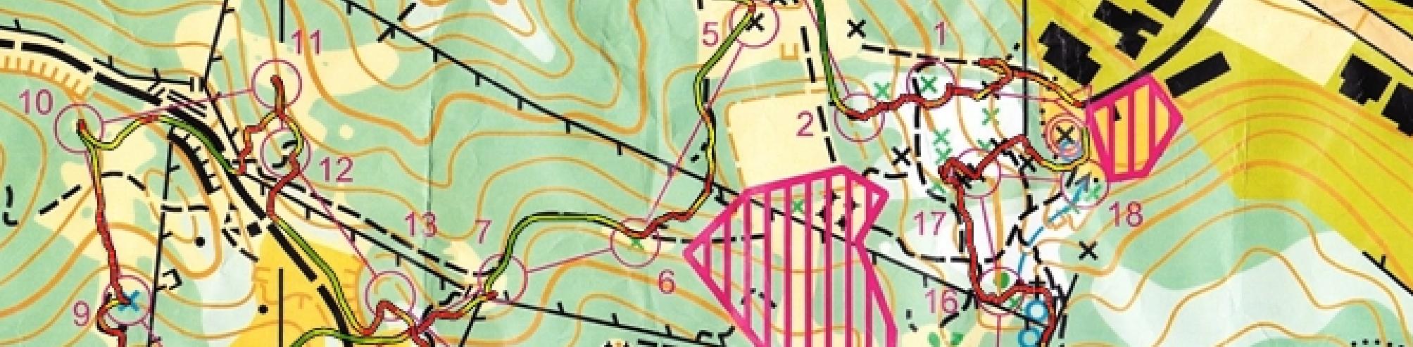
Orienteering race 12:27 [5] 1.4 km (8:54 / km)
shoes: Icebug Spirit2 OLX
Really tight sprint on a 1:2 000 map. Took a while to get into scale and it was really hard to flow because you had to constantly make decisions. 1 Thought I had passed the the track so I turned around and went back, but it was much too early (5 sec). 16 Left was probably fastest, rather than right (20sec).
http://www.numberoneaucklanddoma.com/maps/show_map...
http://www.numberoneaucklanddoma.com/maps/show_map...
Orienteering race 11:44 [5] 1.44 km (8:09 / km)
shoes: Icebug Spirit2 OLX
Another micro sprint at 1:2 000. Was better suited to the scale and won by 4 min this time. Had a clean run and didn't make any mistakes (11 was in the wrong place).
http://www.numberoneaucklanddoma.com/maps/show_map...
http://www.numberoneaucklanddoma.com/maps/show_map...
1 PM
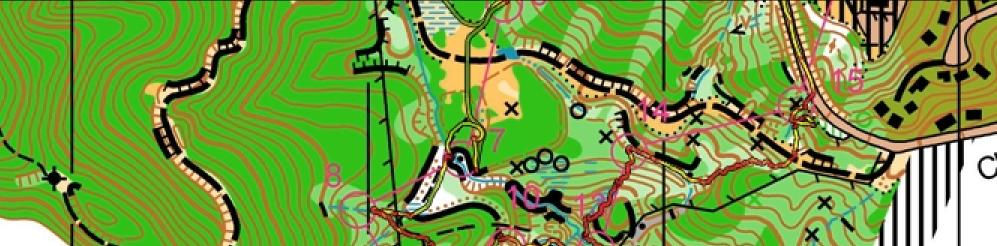
Orienteering race 39:13 [5] 4.5 km (8:43 / km)
rhr:52 slept:10.0 shoes: Icebug Spirit2 OLX
Chasing start middle on Otari. Would have preferred it to be reverse start order, so I was catching everyone. 1 Lost time at the beginning by running to start triangle, then continued ahead on the leg which ended up being the slower route choice. I don't like route choices where the better route is back the way you came from the start triangle, and/or you have practically no time to analyse the options from when you pick up the map until when you have to make a decision (20sec). 2 and 3 The controls were in the wrong place, so I had to search for them, and then run back to the control site to put them in the right place (2 min, 1 min). 4 It looked as though the cliff could be accessed from the top, but there was actually fight (30sec). 9 I missed the track to the right, so I had to cut through the green too low (10 sec). 11 The control was in the wrong place again, so I had to move it back (10sec). Such sick terrain, I love orienteering in this stuff
http://www.numberoneaucklanddoma.com/maps/show_map...
http://www.numberoneaucklanddoma.com/maps/show_map...
Friday Jun 22, 2012 #
7 PM
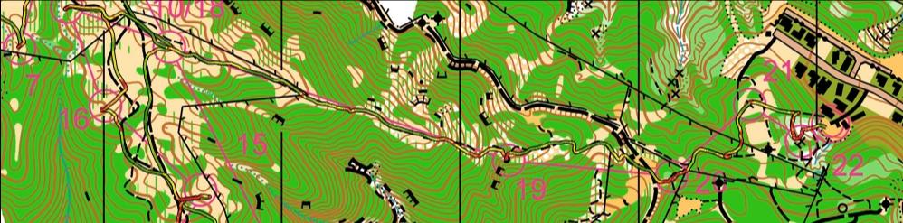
Orienteering race 39:54 [5] 5.5 km (7:15 / km)
rhr:48 shoes: Icebug Spirit2 OLX
Night Race on Otari fundraiser. Had a good run, didn't loose much time at all. 1 Cut in a little early on 1 and had to smash through the fight (20 sec). 9 Little too left (5 sec). 11 Didn't read the description and ran all the way around the cliff until I saw it (20sec). Ran really well since I haven't done much night orienteering at all
http://www.numberoneaucklanddoma.com/maps/show_map...
http://www.numberoneaucklanddoma.com/maps/show_map...
Thursday Jun 21, 2012 #
5 PM
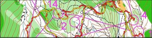
Orienteering 39:02 [5] 5.0 km (7:48 / km)
ahr:172 max:184 slept:7.0 shoes: Icebug Spirit2 OLX
One of the worst maps I have ever run on. Contours are mapped weird, vegetation is not consistent and badly mapped. Really small features mapped which shouldn't be, and all the features are in the wrong places. Whole re-entrant systems are over 100m out, on a 1:5000 map (click on map to see my 'warped' gps route, showning how out everything is). And why the hell is it 5m contours?!?! Also, I am so sick of mappers shrinking symbols so they can fit pointless shit on the map. A 30cm mound of rotten branches is not a knoll! So many shrunken symbols on the map, it is basically impossible to read while running. Single tracks are not 0.1mm thick, man-made objects are not 0.4mm across. And indistinct tracks are not 0.04 mm thick!! That is taking it way too far, 0.7mm black lines are hard enough to see in non-urban areas, viable route choices should not be shown so small that you can only see them on OCAD!
I ran the red long from Sunday's event, but I left it too late until I started so it got pitch black. And it didn't help that my headlamp was practically out of batteries so I had no light. Stumbled the last part down the stream to the finish. But I had no pain from my shins which is so so awesome, I think I can start running again now.
Click on the map to see the un-'warped' gps route and see how out the map is by comparing it to the other route, where I dragged it with about 20 points to make it fit best. But still some sections are way out
http://www.numberoneaucklanddoma.com/maps/show_map...
Wednesday Jun 20, 2012 #
4 PM
Cycling 1:25:01 [3] 19.2 km (13.6 kph)
rhr:51 slept:6.0
Nice cruisy ride on Mount Vic, really muddy so I had to walk most of the up hills, no traction
Tuesday Jun 19, 2012 #
6 PM
Other 40:00 [5]
rhr:54 slept:9.0
Did the hill reps aqua jogging to rest my shins. Did 8, it was pretty tough on the quads. 90 sec efforts with 60 sec recoveries.
Monday Jun 18, 2012 #
12 PM
Cycling 1:04:49 [3] 14.8 km (13.7 kph)
rhr:51 slept:9.0
Picked up questionnaires for geography, so lots of stop start but got 60mins of riding in