Training Log Archive: PGIn the 7 days ending Jun 6, 2010:
| ||||||||||||||||||||||||||||||||||||||||||||||||||||||||||||||||||||||||||||||||||||||||||||
| « | » |
| » now | ||||||||||
| Mo | Tu | We | Th | Fr | Sa | Su | |||||||
Sunday Jun 6, 2010 #
Event: Gay City State Park
Note
Well, it seems I have suddenly become a major film star --
A higher-resolution version is at Barb's log.
The reviews are already coming in. This one is typical --
"A major step forward in the new "rogaine reality" genre. Brilliant. Two thumbs up, way up." -- Roger Ebert
Though there are always the exceptions --
"IMHO, it's pretty lame, FWIW" -- man on the street, possibly known as Randy.
And then from the comments on AP --
"Clearly Academy Award material in several categories, included best director, best cinematography, best actor, best original script, ... best actress ... too."
The sequel has already been shot and should be appearing soon.
11 AM
orienteering 1:13:33 4.95 mi (14:52 / mi) +344ft 13:56 / mi
ahr:149 max:162 rhr:56 slept:9.0 weight:137.5lbs shoes: x-talon 212 #2
NEOC local meet at Gay City, red course, 7.2 km. As usual recently, totally exhausted after about 5 minutes, dragged my ass around the course. No mistakes though. Warm and humid but no rain. Some rain would have been nice.
On the plus side, heels seem to be better. Not sure if good enough that I might actually have to start doing some training, horrible thought that that is....
The map and my route. No problems, except I'm walking (and not very briskly) every time the route isn't full green.
On the plus side, heels seem to be better. Not sure if good enough that I might actually have to start doing some training, horrible thought that that is....
The map and my route. No problems, except I'm walking (and not very briskly) every time the route isn't full green.
QR.jpg)
Saturday Jun 5, 2010 #
11 AM
biking 2:06:44 31.22 mi (4:04 / mi)
ahr:135 max:159 rhr:56 slept:8.0 weight:138lbs
For some reason I got into my mind to go for a "long" ride, for which I am clearly not prepared, even though I was trying to pace myself. Pretty close to a full bonk by the time I finished, very glad it wasn't a couple miles more and/or any more uphills. Took a quick shower when I finished, had a little to drink, sat down on the couch and immediately feel asleep for an hour. And now the legs feel quite trashed.
Hot and humid. I suppose it would have been a good idea to take along something to drink. Weight dropped about 4 pounds.
Hot and humid. I suppose it would have been a good idea to take along something to drink. Weight dropped about 4 pounds.
Friday Jun 4, 2010 #
Note
rhr:55 slept:10.0 weight:139lbs
A little better this morning, pulse not so high, headache mostly gone, rash improving.
Note
In the battle to see who can claim the largest rootstock, the acknowledged lead has been Valerie with this fine specimen from February 2009 in Prince William Forest Park in Virginia --

And also a runner-up --

Well, there is a new entry, this one from Gail, and bearing in mind that perspective is a very tricky thing, it seems quite clear that this one edges out Valerie's for first place.

Or for a larger view.
Note a very important consideration -- we own ours, Valerie just visits hers. :-)
And also a runner-up --
Well, there is a new entry, this one from Gail, and bearing in mind that perspective is a very tricky thing, it seems quite clear that this one edges out Valerie's for first place.
Or for a larger view.
Note a very important consideration -- we own ours, Valerie just visits hers. :-)
11 AM
biking 49:21 13.84 mi (3:34 / mi) +299ft 3:30 / mi
ahr:134 max:161
A little more energetic, meaning that by the end the legs were a little wobbly and I was sweating a lot. Conditioning still sucks.
Plus another morning at the office. What gives? This is supposed to be the off-season. But I got another of my least favorite e-mails, from one of my ladies, saying so-and-so called, they got a letter from the IRS, please give them a call.
They are probably freaking out. And of course all I am thinking is that I hope it's not my fault.... :-)
And fortunately it's almost always not. As was the first case this morning. So then it's just a matter of figuring out what's needed (in this case some of the money the client thought had gone into a traditional IRA had actually been put in a Roth), and knock out a couple of amended returns.
And the second case, friend of a client, didn't file at all, didn't think she had to, but the IRS thinks she should have. Will take care of that one too but have to round up some documents first.
Putting a nice dent in the bill for the rogaine trip.... :-)
Thursday Jun 3, 2010 #
Note
A few post-rogaine reminders for myself:
-- "Heavy cushion" wool socks worked really well. Felt weird when I first put them on, too spongy, but not a single blister.
-- Had too much food again. Took 4 energy bars and 2 baggies full of trail mix. Ate just 2 of the energy bars and less than half the trail mix. It's nice to have a little in reserve but that's a bit much. Both the bars and the mix have quite a lot of protein and fat, so they last longer.
-- Took half a 200mg caffeine pill a couple of times, once quite early in the night, another not long before dawn. Barb, too. I think it helped. Plus another full pill about 30 minutes after we finished to get me wired for the 90-minute drive back to Madras. Had no problem staying awake for that. Barb, on the other hand, self appointed to entertain me to keep me awake, every once in a while things would be quiet for a minute or two, and then she'd make a little start and say she'd just been off to dreamland and back, for all of 30 seconds or so, and had weird dreams to report. Quite an interesting drive!
-- The battery on the Tesla is supposed to last something like 1.5 hours on high beam, or 8 hours on medium beam, or 24 hours on low beam. What it really needs is something that shows how much power is left. In the absence of that, I was of course conservative, most of the time on low beam, maybe 10% of the time at medium and 5% at high. I assume there was plenty of power left. The beam certainly didn't fade at all.
-- It might be a good idea to try using a trekking pole or two. I might fall down less. It might take a little effort, but I should be able to deal with the resulting self-image problem.
-- Maybe the compass around the neck right from the start would be a good idea.
-- Maybe time to investigate a tow rope (and how it works as the towee).
Hopefully there are still a few more rogaines in my future. They are wonderful adventures, even at a slower pace.
5 PM
biking 41:10 11.0 mi (3:45 / mi) +233ft 3:40 / mi
ahr:126 max:147 weight:139lbs
A late afternoon short and not too energetic ride, just because I felt I should do something. Been feeling quite wiped out, plus dealing with caffeine withdrawal headache after bingeing during/after the rogaine. At least I managed a mid-afternoon nap, though I checked my pulse after that, still flat on my back, and it was 65, way too high. So not pushing it on the bike.
I'm assuming at the point the natural fluctuations in life will have me feeling better.
At least I managed to take care of one client this morning, a common situation this time of year, she hadn't filed since 2006. Got all 3 years done, got Mass. DOR to suspend collection efforts for 60 days, and she left quite happy.
And I made a nice dent in my rogaine trip bills. :-)
Wednesday Jun 2, 2010 #
Note
slept:9.0 weight:140.5lbs
Almost forgot, Monday evening at the Portland airport ticket counter, the obligatory post-rogaine weigh-in (much to the amusement of the agent), fully clothed and shod and the wrong time of day so clearly not an official G measurement. And the numbers were: me 144.0, Barb 138.5.
Needless to say, she was delighted. I was stoic.
Needless to say, she was delighted. I was stoic.
Note
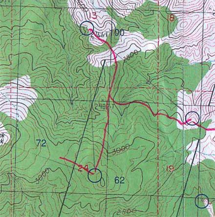
Here's our routes for the rogaine, first the west half of the map, covers where we were for the first 9 hours and a bit at the end (click here for the overall view), plus a few notes....
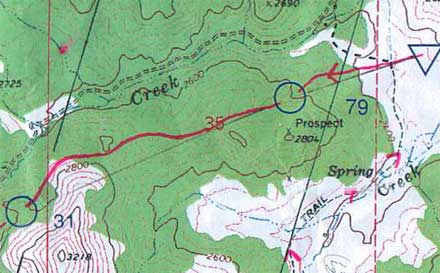
Lots of folks ahead of us going up to 79. And then all by ourselves to 31. Clearly we had a special route. It was also clear pretty quick that the navigation was mostly simple. You could usually see the feature you were heading to from a longs ways away.
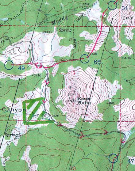
First of many pain-in-the-butt climbs. I already knew they would be a struggle. Dropped our packs for a little bit on the short out-and-back to 49. On the long gradually downhill road to 47 we just walked (no plans for running today).
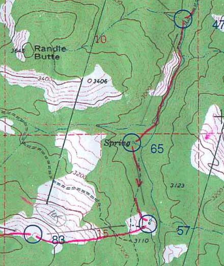
65 was less obvious but not hard, just up the slope a little ways and quite a lot of trees cut the visibility. 57 looked like it might be difficult (the margins between white and green were usually useless), but in the case the open area was very well defined. One of those legs where you pay really close attention and then the point turns out to be obvious. Oh, well, better than the other way around.
83 was just up.
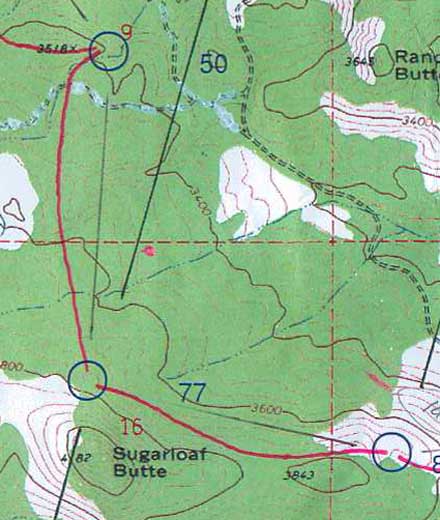
Rough footing on the rocky hillside to 77 but easy navigation.
To 50, I spaced out a little, thought we were going a little straighter and were closer and was getting uncertain, but Barb had things under control. Clue was a rock outcrop, lots of them in the area. Control was on the second one we checked.
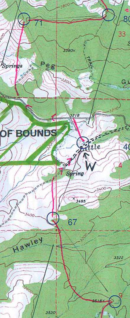
A left swing to 67 to minimizing the steep sidehills, trade them for a steep down and up at the end.
Could see where 71 was going to be from half a mile away, also look across and see where 80 would be.
Nice route to 80. Nothing special, just very much in control, picking up the little subtleties in the contours and came out at exactly the right level. Didn't need to, easy point, but good practice.
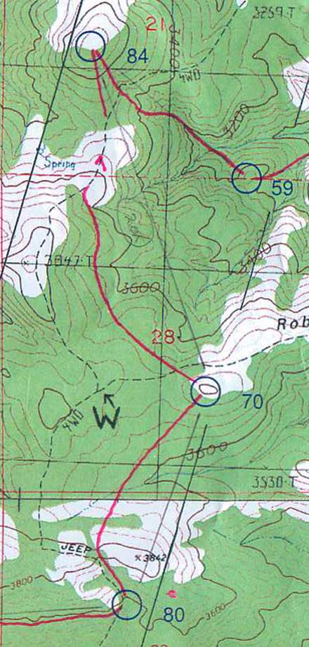
For 70, got over the first ridge, check the compass, yup, there's the hill we're going to.
For 84, check the compass, yup, there's the hill we're going to.
For 59, check the compass, yup, there's the hill we're going to.
60 was a nice leg, almost wish we could have done it at night. Had to pay attention a little. By the way, we were alone almost all the time in the whole section, just a couple of groups going the other way.
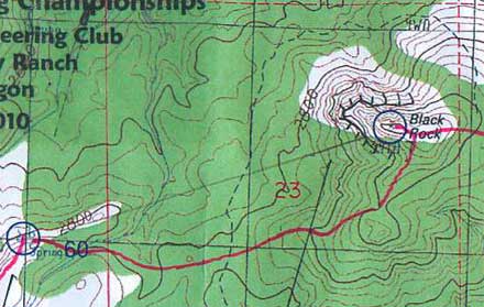
For 72, Black Rock, didn't need to check the compass, it was obvious where we were going. We originally thought we would go up the reentrant SW of it, but it was steep and had lots of outcrops, so we swung a little further right.
Wonderful views in the early evening. Maybe another hour or a little more of daylight. No problems so far.
================================
Continued....
Here's our routes for the eastern half of the rogaine, covers where we were from about an hour before dark to about an hour after daylight (click here for the overall view), plus a few notes....
For 62, once again, check the compass, yup, that's the hill.
To 100, a little more interesting, find the correct spur. The sun was down, plenty of light to get to 100, not sure about enough for 52.
Heard voices approaching 100. It was a team of 5, one or two of them females, fairly young, looked very professional, strong, fast, good material for a photo shoot for sure, an AR team I assume. They were going the other way. Didn't actually seem to be moving very fast nor know quite what they were doing, but they did look great.
To 52, it seemed easier to retrace our steps a ways and then contour across, saved a bunch of descent and climb, also easier to find the control. Last bits of daylight, spiked the control oh so nicely, right in front of us as we crested the spur.
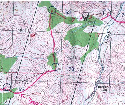
Kept going just a bit more toward 78 to get in the correct reentrant, then couldn't read the map any more and stopped to get out the headlights. I was trying my Tesla for the first time on a rogaine, Barb had something different, also very good. And they worked really nice, as we were dropping down towards 78 you could pick up all the side spurs and reentrants, then the little knoll on the left, plus the profiles of the knolls up on the ridge behind 72 were visible. Hit the last hillside just right of the little spur, slid left and there was the point. Nice.
To 63, looked complicated, what the hell, let's just go straight. Down across the bigger reentrant, then generally climbing but dipping through a couple deep little reentrants, then over the flat spur, then down again, everything still matching up, past a couple of reentrants coming down from the left, over a modest spur, across a little reentrant, up on a very small spur, and boom, we light up the control maybe 20 yards to our left.
Isn't this more fun than daytime?
Beat our way through some junky stuff to get to the trail leading to the water drop, nicely timed, I'd gone dry about 10 minutes earlier. And we were talking about the approach to 73, and how there were no nice obvious features, and I said why not just go down the trail until we could see the road and then back in from there. Which was the plan.
Until we had gone a ways and I looked more at the map and said, there are 3 distinct spurs over there and it's behind the second one, I wonder if we can see anything. And flipped the Tesla to high beam and looked over to the left and there was the first spur and beyond it the second.
So we ditched plan A and went straight at it, and before long the third spur was lit up, and we rounded the corner behind the second and lit up the control maybe 75 meters above us. Sweet.
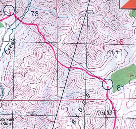
Sweet, yes, except for what came next, worst climb of the whole thing. Crossed Muddy Creek and then up, up, up. Endless. Though of course it did end, and as we popped out on top there to greet us was the just-risen full moon, right in front of us.
In the old days, full moon or not, the old days meaning any previous rogaine I've done, it would now have been a matter of careful compass and pace along the ridge so as to be quite sure to drop off at just the right place to get the control.
The new technique -- go more or less east, yup, can see the bend from a good distance so turn right a little, yup, can see the next bend from a good distance so turn left a little, slowly mosey over to the top of the slope on the right, go a little ways, and bingo, light up the control from about 150 meters away.
It's so cool it just can't be legal, but apparently it is.
Oh, and pace counting, what's that?

53 was also interesting, across the shoulder of the hill to our south, get in the correct reentrant, follow it down the right distance, and then traverse to get the control. Just as we did, very nice.
Except, it being dark and all, and me being several times more spastic in the dark than in the daylight, so on a fairly regular basis I was just going Splat, and on one of those splats going down the reentrant my compass introduced itself to a rock and that was the end of the compass. Fortunately Barb had a spare, it hung around my neck, I looked just like all the clueless beginners do, but that must have been the right place for it as it survived the rest of the journey.
I will point out that 53 was quite well hidden, we only lit it up from about 50 meters away.
Next to the water, down to the main valley. It had been getting colder, and now seemed even more so, put on all our extra clothes, the valley was probably a cold spot, must have been close to freezing.
A short out-and-back to 74, no pacing, no sweat.
And then life started getting miserable, at least for me. To 69, endlessly up a scruffy drainage, struggling to keep up to Barb, annoying vegetation, regular splats. But the control was right where it was supposed to be (as were all the others we went to).
Wrote about 58 a couple of days ago here. A miss but a reasonable recovery.
To 75, first a steep little drop down to cross the drainage. I headed down, she objected, wanted to go around where it was less steep, I persisted, she yelled she didn't want to do it, I persisted, she managed fine but was quite unhappy. I, well, OK, guilty as charged....
Up to the saddle, by now she was once again out front, me trying to keep up. And then down, easy. Saw another team here for just a moment, first folks we'd seen for many hours.
Another miserable uphill. At some point along here Barb told me to give her her fanny pack, which I'd been carrying up to then under the mistaken assumption that I was the stronger of us. Not even a hint of objection from me. Felt nice to be rid of it. Not that I suddenly felt good, just not quite so bad.
The climb finally ended, the order stayed the same, Barb in charge, me hanging on. Over to 45, nice gently rolling terrain, no problem.
To 55, left slope of the big hill, I have a pretty good idea where we went, as I struggled within 50 meters of her out front, cooking away. Was this payback time for the steep slope? :-)
Just slightly too high on the approach, and the reflector was covered by some leaves, had to do a slight turn-back to get it, no big deal.
Off to 85, by now the sky was starting to lighten a little. Went left and up the drainage, miserable again. At some point I asked for a short stop, during which Barb offered to take my pack (so she would be carrying her pack, her fanny pack, and my pack, and I would be carrying nothing). And my male ego just couldn't handle that.
So I refused. And got very slightly pissed. And then it seemed like this perceived insult gave me a burst of adrenaline, because I started moving better. And it was the end of the 50-meters behind, oh I feel awful routine of the previous several hours. So her offer was in fact very useful. The old maxim, what really matters is what goes on between the ears.
Got to 85, climbed out, no need for the headlamps anymore so we turned them off, I put mine away, Barb kept hers on for quite a while. Fashion statement? No, I think it was just her turn to get a little spacy.

Daylight now, perfect timing, got all the harder stuff done at night.
Hmm, 64, a road bend, spiked it!

Hmm, 56, a hilltop, spiked it!

Hmm, 76, hilltop, trail all the way, spiked it, we are good!
A little more interesting to 101, though you could see right where it was going to be. Down to the big saddle, along the slope climbing three or four lines, a nice little saddle.

Down and around to 68, I'm actually leading for once, nicely avoiding the very steep slopes.... :-)
Spiked it, needless to say.
And then 36, an old mine, easy, and 37, a small hill, easy, and we had done our plan and still 80 or 90 minutes to go. Time to pop the question -- do you want to get any more controls?
Sure, she said. Cool. Extra cool. So fine to finish a rogaine in style, getting all you can rather than packing it in early. Not any high-pointers around, it probably would not make any difference in the final standings, but still very cool.
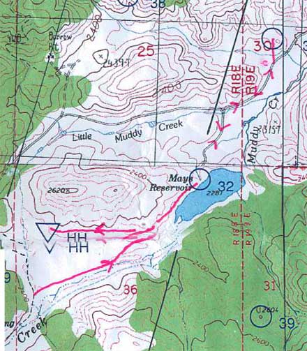
So we bypassed the hash house and headed for 32. The thinking was, if we still had an hour left when we got there, we'd go for 35.
Got there right at 10 am, a hour to go. Started off to 35. A brief conversation, the gist being, is this crazy? We don't want to be late.
Pop the next big question -- do you want to run some?
Sure, she said. Even more super cool. So off we trotted, dropping the packs since we were coming back the same way, ran just about all the way to 35 and it wasn't totally awfully miserable. And we got there so freaking fast, 10:11. A slight sense of how I used to be able to do rogaines.
So plenty of time to get back, ran a bit back to the packs, and then walked the rest of the way, still rather briskly, got in 15 minutes early. As I said, so nice to finish in style.
Such a fine rogaine.
.jpg)
Lots of folks ahead of us going up to 79. And then all by ourselves to 31. Clearly we had a special route. It was also clear pretty quick that the navigation was mostly simple. You could usually see the feature you were heading to from a longs ways away.
First of many pain-in-the-butt climbs. I already knew they would be a struggle. Dropped our packs for a little bit on the short out-and-back to 49. On the long gradually downhill road to 47 we just walked (no plans for running today).
65 was less obvious but not hard, just up the slope a little ways and quite a lot of trees cut the visibility. 57 looked like it might be difficult (the margins between white and green were usually useless), but in the case the open area was very well defined. One of those legs where you pay really close attention and then the point turns out to be obvious. Oh, well, better than the other way around.
83 was just up.
Rough footing on the rocky hillside to 77 but easy navigation.
To 50, I spaced out a little, thought we were going a little straighter and were closer and was getting uncertain, but Barb had things under control. Clue was a rock outcrop, lots of them in the area. Control was on the second one we checked.
A left swing to 67 to minimizing the steep sidehills, trade them for a steep down and up at the end.
Could see where 71 was going to be from half a mile away, also look across and see where 80 would be.
Nice route to 80. Nothing special, just very much in control, picking up the little subtleties in the contours and came out at exactly the right level. Didn't need to, easy point, but good practice.
For 70, got over the first ridge, check the compass, yup, there's the hill we're going to.
For 84, check the compass, yup, there's the hill we're going to.
For 59, check the compass, yup, there's the hill we're going to.
60 was a nice leg, almost wish we could have done it at night. Had to pay attention a little. By the way, we were alone almost all the time in the whole section, just a couple of groups going the other way.
For 72, Black Rock, didn't need to check the compass, it was obvious where we were going. We originally thought we would go up the reentrant SW of it, but it was steep and had lots of outcrops, so we swung a little further right.
Wonderful views in the early evening. Maybe another hour or a little more of daylight. No problems so far.
================================
Continued....
Here's our routes for the eastern half of the rogaine, covers where we were from about an hour before dark to about an hour after daylight (click here for the overall view), plus a few notes....
.jpg)
For 62, once again, check the compass, yup, that's the hill.
To 100, a little more interesting, find the correct spur. The sun was down, plenty of light to get to 100, not sure about enough for 52.
Heard voices approaching 100. It was a team of 5, one or two of them females, fairly young, looked very professional, strong, fast, good material for a photo shoot for sure, an AR team I assume. They were going the other way. Didn't actually seem to be moving very fast nor know quite what they were doing, but they did look great.
To 52, it seemed easier to retrace our steps a ways and then contour across, saved a bunch of descent and climb, also easier to find the control. Last bits of daylight, spiked the control oh so nicely, right in front of us as we crested the spur.
Kept going just a bit more toward 78 to get in the correct reentrant, then couldn't read the map any more and stopped to get out the headlights. I was trying my Tesla for the first time on a rogaine, Barb had something different, also very good. And they worked really nice, as we were dropping down towards 78 you could pick up all the side spurs and reentrants, then the little knoll on the left, plus the profiles of the knolls up on the ridge behind 72 were visible. Hit the last hillside just right of the little spur, slid left and there was the point. Nice.
To 63, looked complicated, what the hell, let's just go straight. Down across the bigger reentrant, then generally climbing but dipping through a couple deep little reentrants, then over the flat spur, then down again, everything still matching up, past a couple of reentrants coming down from the left, over a modest spur, across a little reentrant, up on a very small spur, and boom, we light up the control maybe 20 yards to our left.
Isn't this more fun than daytime?
Beat our way through some junky stuff to get to the trail leading to the water drop, nicely timed, I'd gone dry about 10 minutes earlier. And we were talking about the approach to 73, and how there were no nice obvious features, and I said why not just go down the trail until we could see the road and then back in from there. Which was the plan.
Until we had gone a ways and I looked more at the map and said, there are 3 distinct spurs over there and it's behind the second one, I wonder if we can see anything. And flipped the Tesla to high beam and looked over to the left and there was the first spur and beyond it the second.
So we ditched plan A and went straight at it, and before long the third spur was lit up, and we rounded the corner behind the second and lit up the control maybe 75 meters above us. Sweet.
Sweet, yes, except for what came next, worst climb of the whole thing. Crossed Muddy Creek and then up, up, up. Endless. Though of course it did end, and as we popped out on top there to greet us was the just-risen full moon, right in front of us.
In the old days, full moon or not, the old days meaning any previous rogaine I've done, it would now have been a matter of careful compass and pace along the ridge so as to be quite sure to drop off at just the right place to get the control.
The new technique -- go more or less east, yup, can see the bend from a good distance so turn right a little, yup, can see the next bend from a good distance so turn left a little, slowly mosey over to the top of the slope on the right, go a little ways, and bingo, light up the control from about 150 meters away.
It's so cool it just can't be legal, but apparently it is.
Oh, and pace counting, what's that?
53 was also interesting, across the shoulder of the hill to our south, get in the correct reentrant, follow it down the right distance, and then traverse to get the control. Just as we did, very nice.
Except, it being dark and all, and me being several times more spastic in the dark than in the daylight, so on a fairly regular basis I was just going Splat, and on one of those splats going down the reentrant my compass introduced itself to a rock and that was the end of the compass. Fortunately Barb had a spare, it hung around my neck, I looked just like all the clueless beginners do, but that must have been the right place for it as it survived the rest of the journey.
I will point out that 53 was quite well hidden, we only lit it up from about 50 meters away.
Next to the water, down to the main valley. It had been getting colder, and now seemed even more so, put on all our extra clothes, the valley was probably a cold spot, must have been close to freezing.
A short out-and-back to 74, no pacing, no sweat.
And then life started getting miserable, at least for me. To 69, endlessly up a scruffy drainage, struggling to keep up to Barb, annoying vegetation, regular splats. But the control was right where it was supposed to be (as were all the others we went to).
Wrote about 58 a couple of days ago here. A miss but a reasonable recovery.
To 75, first a steep little drop down to cross the drainage. I headed down, she objected, wanted to go around where it was less steep, I persisted, she yelled she didn't want to do it, I persisted, she managed fine but was quite unhappy. I, well, OK, guilty as charged....
Up to the saddle, by now she was once again out front, me trying to keep up. And then down, easy. Saw another team here for just a moment, first folks we'd seen for many hours.
Another miserable uphill. At some point along here Barb told me to give her her fanny pack, which I'd been carrying up to then under the mistaken assumption that I was the stronger of us. Not even a hint of objection from me. Felt nice to be rid of it. Not that I suddenly felt good, just not quite so bad.
The climb finally ended, the order stayed the same, Barb in charge, me hanging on. Over to 45, nice gently rolling terrain, no problem.
To 55, left slope of the big hill, I have a pretty good idea where we went, as I struggled within 50 meters of her out front, cooking away. Was this payback time for the steep slope? :-)
Just slightly too high on the approach, and the reflector was covered by some leaves, had to do a slight turn-back to get it, no big deal.
Off to 85, by now the sky was starting to lighten a little. Went left and up the drainage, miserable again. At some point I asked for a short stop, during which Barb offered to take my pack (so she would be carrying her pack, her fanny pack, and my pack, and I would be carrying nothing). And my male ego just couldn't handle that.
So I refused. And got very slightly pissed. And then it seemed like this perceived insult gave me a burst of adrenaline, because I started moving better. And it was the end of the 50-meters behind, oh I feel awful routine of the previous several hours. So her offer was in fact very useful. The old maxim, what really matters is what goes on between the ears.
Got to 85, climbed out, no need for the headlamps anymore so we turned them off, I put mine away, Barb kept hers on for quite a while. Fashion statement? No, I think it was just her turn to get a little spacy.
Daylight now, perfect timing, got all the harder stuff done at night.
Hmm, 64, a road bend, spiked it!
Hmm, 56, a hilltop, spiked it!
Hmm, 76, hilltop, trail all the way, spiked it, we are good!
A little more interesting to 101, though you could see right where it was going to be. Down to the big saddle, along the slope climbing three or four lines, a nice little saddle.
Down and around to 68, I'm actually leading for once, nicely avoiding the very steep slopes.... :-)
Spiked it, needless to say.
And then 36, an old mine, easy, and 37, a small hill, easy, and we had done our plan and still 80 or 90 minutes to go. Time to pop the question -- do you want to get any more controls?
Sure, she said. Cool. Extra cool. So fine to finish a rogaine in style, getting all you can rather than packing it in early. Not any high-pointers around, it probably would not make any difference in the final standings, but still very cool.
So we bypassed the hash house and headed for 32. The thinking was, if we still had an hour left when we got there, we'd go for 35.
Got there right at 10 am, a hour to go. Started off to 35. A brief conversation, the gist being, is this crazy? We don't want to be late.
Pop the next big question -- do you want to run some?
Sure, she said. Even more super cool. So off we trotted, dropping the packs since we were coming back the same way, ran just about all the way to 35 and it wasn't totally awfully miserable. And we got there so freaking fast, 10:11. A slight sense of how I used to be able to do rogaines.
So plenty of time to get back, ran a bit back to the packs, and then walked the rest of the way, still rather briskly, got in 15 minutes early. As I said, so nice to finish in style.
Such a fine rogaine.
Tuesday Jun 1, 2010 #
12 PM
Note
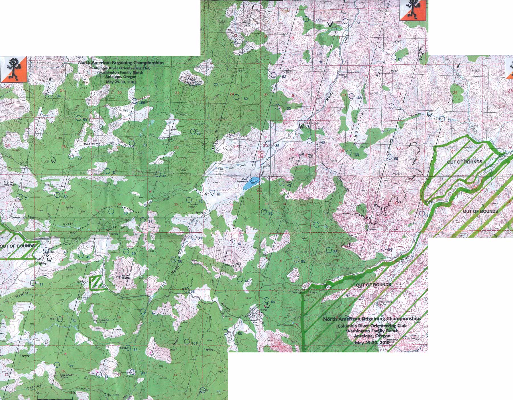
Here a map of the Big Muddy rogaine, with our planned route on it, starting with #79. Actual order of controls was exactly the same except for adding a couple of controls at the end (32 and 35) when we had a little time left over.
For anyone interested in the planning process, and how we managed to pick the dumbest route from a purely strategic/competitive perspective, but also by far the smartest route from a make-the-night-fun perspective, here's a bit of the thinking. If it seems not so well thought out, well, we were quite happy with it.
First, it seemed like a big loop around the outside made sense, getting all the higher point ones, with the exception of 54 and 82 which were too far out of the way for us. We both agreed on that. If by any chance there was time left over, there were more controls available close in.
Second, it seemed like starting in the south/southwest, and finishing in the southeast/south, gave easy access to this outer loop.
Third, we just connected what seemed like a reasonable number of circles.
Fourth, we measured the beeline distance, not quite 60 km, right about what we thought we could do.
And damn, we were basically done in less than 30 minutes of planning (we had about 2 hours), except for ....
Fifth, take a quick look to see that at least a few of the night ones are interesting (i.e. more difficult). And they certainly were. Cool. We were done. Plenty of time to hang out before the start, and no stress.
A cynic might say that we could hardly have made the day any easier, nor the night much harder, a polite way of saying we had the worst possible route. We'll take that as a compliment. :-)
I'll put up our routes and a few comments, but it's won't be until tomorrow. zzzzzzzzzz.....
4 PM
Note
slept:2.0
Sometimes the little things in life are important. Like when I called up my doctor's office when I got back to Boston this morning and asked for an appointment, and rather than saying the first thing available was in a week or two, they said, Can you come in at 3 this afternoon? Maybe it's just one of the benefits of living in a small town.
Skipping the various details (Kissy would certainly nail me for a TMI infraction), I'm now starting on the treatment for Lyme disease, Doxycycline, plus another general antibiotic just for good measure.
I suppose I should check with Clint and Phil as to their experience with this.
Skipping the various details (Kissy would certainly nail me for a TMI infraction), I'm now starting on the treatment for Lyme disease, Doxycycline, plus another general antibiotic just for good measure.
I suppose I should check with Clint and Phil as to their experience with this.
C • Doxy 21
6 PM
Note
Up to Greenfield to get the prescriptions, they're even free, yup, totally free, under some antibiotic special at Stop & Shop.
Get home, ready to get some medicine working, and then to post the rogaine map after dinner, the story already mostly written in my mind, and the phone rings. Nice woman that took care of me at the pharmacy. Seems I left the prescriptions in the shopping cart. So back I have to go, another 20 minutes each way.
Would somebody please just shoot me....
Monday May 31, 2010 #
2 PM
Note
I'll post the map and our route when I get home.
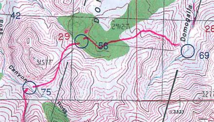
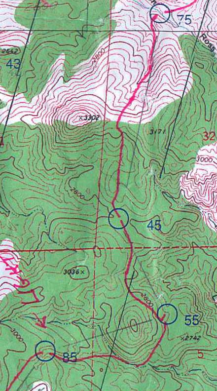
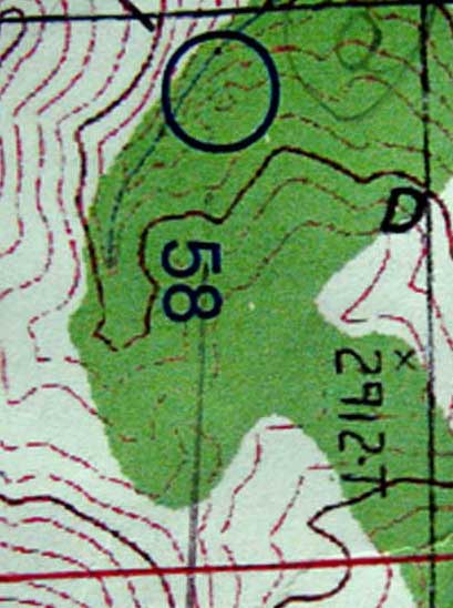
But here's a sample, the one control we had trouble with, going to 58 from 69, sometime around 2 am. One of several night legs that we had planned to test our night O'.
(As I've done more rogaines, the night part has gone from being terrifying, to scary, to anxious, to maybe sort of fun, to more interesting than the day parts, to the best part of the rogaine. We deliberately didn't try to find easier legs, i.e. more road sections or more open country, for the night, in fact we checked our planned route as an afterthought just to make sure there would be some challenging night sections.)
The plan here was a bit of a right swing to avoid going over the top of the ridge, then a challenging diagonal approach (generally harder than "with the grain" or "across the grain" approaches) across some mottled terrain.
The problem was we couldn't read the map in the green section (green was scattered trees, not thick vegetation), the contours were either faint or completely washed out. Plus, of course, with 40-foot contours, there is always more happening than the map shows, more knolls, more reentrants, etc.
Kept going, on a bearing, nothing in the terrain made much sense. Barb spotted a nice knoll off to our left, we checked it out, nothing. In retrospect, I think it was on the spur just south of the "5" in "58."
The problem with veering off to something you think might be the right spot, and then it isn't, is that your sense of where you really are is now quite bad.
So back to a skill I almost never use (because I usually know where I am), back bearings. I could pick out the profile of the hill lying grid south of 58, and that confirmed we were too far east, hadn't gone far enough. So we headed west a bit, checked the horizon again, not quite enough, went further, and then the Tesla lit up the control from about 75 meters away. Very fine.
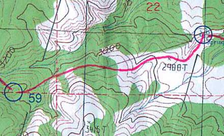
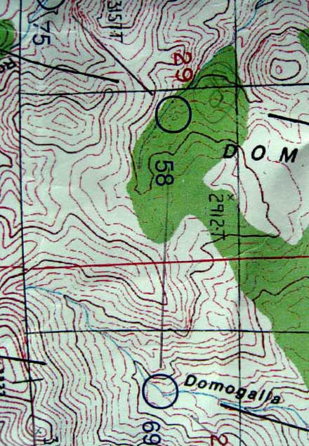
One more thing for Barb's rogaine committee to think about -- map printing. Just because the maps are old school for accuracy doesn't mean they have to be old school for printing. Here's the area around 58 blown up --
But here's a sample, the one control we had trouble with, going to 58 from 69, sometime around 2 am. One of several night legs that we had planned to test our night O'.
(As I've done more rogaines, the night part has gone from being terrifying, to scary, to anxious, to maybe sort of fun, to more interesting than the day parts, to the best part of the rogaine. We deliberately didn't try to find easier legs, i.e. more road sections or more open country, for the night, in fact we checked our planned route as an afterthought just to make sure there would be some challenging night sections.)
The plan here was a bit of a right swing to avoid going over the top of the ridge, then a challenging diagonal approach (generally harder than "with the grain" or "across the grain" approaches) across some mottled terrain.
The problem was we couldn't read the map in the green section (green was scattered trees, not thick vegetation), the contours were either faint or completely washed out. Plus, of course, with 40-foot contours, there is always more happening than the map shows, more knolls, more reentrants, etc.
Kept going, on a bearing, nothing in the terrain made much sense. Barb spotted a nice knoll off to our left, we checked it out, nothing. In retrospect, I think it was on the spur just south of the "5" in "58."
The problem with veering off to something you think might be the right spot, and then it isn't, is that your sense of where you really are is now quite bad.
So back to a skill I almost never use (because I usually know where I am), back bearings. I could pick out the profile of the hill lying grid south of 58, and that confirmed we were too far east, hadn't gone far enough. So we headed west a bit, checked the horizon again, not quite enough, went further, and then the Tesla lit up the control from about 75 meters away. Very fine.
One more thing for Barb's rogaine committee to think about -- map printing. Just because the maps are old school for accuracy doesn't mean they have to be old school for printing. Here's the area around 58 blown up --
3 PM
hike 43:30 [0] 1.39 mi (31:18 / mi) +161ft 28:12 / mi
slept:9.0 shoes: saloman
Post-rogaine recovery hike to Bagby Hot Springs for a soak. A little bit of light rain on and off, also a little bit of sunshine on the way out.
It took a bit to get there as the Google recommended route did not considered road conditions...

... so we made a wise retreat and tried a different approach and got there successfully. Very beautiful country...

Plus a hillside that was just like some northern Scandinavian forests, bare rock and moss and the very occasional tree, except this one needs to be tilted quite severely before anyone but Ross can run up it...

The soak was great, but the legs seem to be getting sorer as the day goes on. But no blisters at least.
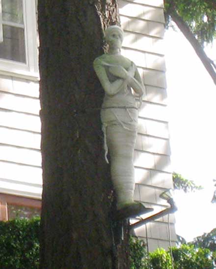
Then a drive back to Portland, a quick perusal of one of the neighborhoods up on the hill just west of downtown where every home was posh but only one seemed to have a mummy out front.
And then to the airport and a wait for the red-eye. But they have free WiFi! :-)
It took a bit to get there as the Google recommended route did not considered road conditions...
... so we made a wise retreat and tried a different approach and got there successfully. Very beautiful country...
Plus a hillside that was just like some northern Scandinavian forests, bare rock and moss and the very occasional tree, except this one needs to be tilted quite severely before anyone but Ross can run up it...
The soak was great, but the legs seem to be getting sorer as the day goes on. But no blisters at least.
Then a drive back to Portland, a quick perusal of one of the neighborhoods up on the hill just west of downtown where every home was posh but only one seemed to have a mummy out front.
And then to the airport and a wait for the red-eye. But they have free WiFi! :-)