Training Log Archive: GswedeIn the 7 days ending Dec 31, 2017:
| |||||||||||||||||||||||||||||||||||||||||||||||||||||||||||||||||||||||||||||||
| « | » |
| » now | ||||||||||||||
| Mo | Tu | We | Th | Fr | Sa | Su | |||||||||||
Sunday Dec 31, 2017 #
11 AM
Orienteering 2:45:02 [3] *** 21.32 km (7:44 / km) +620m 6:45 / km
ahr:157 max:187 25c

So, I had to do a long run and wanted to explore the French Creek East map to see what state the vegetation was in. I'm ecstatic; it was beautiful out there. The area of the 2012 fire, outlined in pink thanks to Ed Scott's fieldwork, is mostly unusable (80-90% of the area). Some parts are crossable, not fun, but crossable. Based on this long run, I'd say 80-90% of FCE outside of the burn is beautiful forest, as nice as French Creek North if not better. The problem is the invasive wineberry that has taken hold in the burn area.
#2 was the wake-up call to how difficult that north slope would be. I crossed the trail and power line, entered the forest, and quickly entered into what my friend Luis calls the "fourth-dimension of orienteering." I was on a rocky, snow-covered hillside with no reliable features for relocation. This is where French Creek is technical, not in extremely detailed areas with micro-contours, but on sweeping hillsides which appear to be almost exactly the same everywhere. #2 reminded me how much respect I would need for # 8, 9, 10, 11.
I wasn't able to run fast today, too much snow. But with what I saw of the forest, it's calling for a long, hard effort in warmer months.
Kswede offered to come out with me. That helped a lot actually. It's tough to get out for a run like this by yourself at 16F/-9C.
Saturday Dec 30, 2017 #
Circuit Training 15:00 [2]
Functional Strength
12 PM
Running 1:20:00 12.59 km (6:21 / km) +278m 5:43 / km
ahr:155 max:175
Short hill workout in the Wiss. I didn't want to do too much because I've got quite a long run tomorrow and the goal is to feel strong for that.
Really difficult to get moving quickly in the snow. Feet slipped every step. It was like running in sand. On the positive side, I had to breath pretty hard, but my legs never hurt. It looks like they've gotten pretty strong for hills. But that also means I'll have to do harder workouts.
Really difficult to get moving quickly in the snow. Feet slipped every step. It was like running in sand. On the positive side, I had to breath pretty hard, but my legs never hurt. It looks like they've gotten pretty strong for hills. But that also means I'll have to do harder workouts.
Friday Dec 29, 2017 #
Core O'Clock 1:00:00 [2]
A variation on core o-clock. An hour of yoga at the Art Museum.
12 PM
Orienteering 1:54:52 [3] 16.8 km (6:50 / km) +368m 6:10 / km
ahr:157 max:175
Orienteering on French Creek East and West. Exploring to see where the veg is good, bad, and unusable. Lots of areas that were spectacular...and others that were whatever the opposite of spectacular is.
Thursday Dec 28, 2017 #
Running 1:10:00 [3] 13.0 km (5:23 / km) +250m 4:55 / km
Core O'Clock 25:00 [2]
100 pushups, 20 pedestal, 5 minute calf raise, 10 minute plank, 20 pullups
Circuit Training 10:00 [2]
Functional strength routine
Note
It's getting awfully lonely training at an elite level here.
Wednesday Dec 27, 2017 #
1 PM
Orienteering 45:45 [4] **** 6.43 km (7:07 / km) +178m 6:15 / km
ahr:155 max:182 21c
Hypothetical WOC Middle in Hickory Run
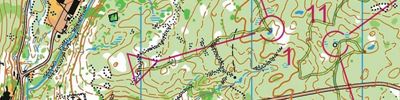
Loads of thanks to my clubmates Eric W and Sandy F for setting and vetting (and streamering!) this course. The idea was to create a middle distance course as if WOC were held in Hickory Run. This course brought together all the greatest parts of the area surrounding the park office. Visibility was good today as there are no leaves left, but the saplings are still there. It was difficult to stay focused while fighting through the vegetation. I wore a GoPro chest harness for this, I'm going to see if I can upload a video analysis later.
Pretty cold today at 16°F/-9°C. But on the bright side, that's generally about as cold as it gets around here and everything else will seem warm now.
Most of the course went very well. But on two controls, 11 and 13, I was executing everything well until the final attack. At that point, I lost confidence in my navigation and assumed I had lost contact. But, had I stay focused and continued, I would have spiked both. Once again, the balance is underlined between trusting yourself and knowing when you've made a mistake.
So, I figured out how to make the camera analysis work.
Some pros and cons:
Pros:
-Great way to accurately do course review. You can actually see what the terrain looked like.
-Very useful for the US to prepare for international competitions. For instance, when I was in Estonia I tried to send pictures and map cut-outs to my teammates with my thoughts. Sending a video of my course could be much more powerful to prepare our athletes for certain mapping styles. And only one athlete would need to be at the location. So, loads of benefits at a much lower price.
-The chesty harness is very comfortable to run in. I hardly noticed it. Con for this below.
-It was very motivating to know that I wasn't "alone" in the woods. On a cold, snowy day in Hickory Run. It can be tough to get your motivation up. Knowing that others might be watching my actions helps get me more serious.
Cons:
-Chesty harness: hands and hills. It was easy to block.
-Distraction from the course?
-Lots of editing to get the video right. And even so, my track is slightly off in a few areas because I didn't set it properly. Lesson learned.
Running 40:00 [2] 6.0 km (6:40 / km)
Tuesday Dec 26, 2017 #
3 PM
Running 33:30 [3] 5.68 km (5:54 / km) +210m 4:59 / km
ahr:155 max:179
Testing out the Virtual Punch app made by Jan Kocbach. It works pretty well. Only problem is it crashes after one course and I need to reinstall it. Still better than hanging controls.
Running 36:30 [3] 6.35 km (5:45 / km) +141m 5:10 / km
ahr:160 max:176
Finishing up the run. Feeling mostly recovered from my sickness. Hickory Run tomorrow!!!