Training Log Archive: ndobbsIn the 7 days ending Sep 29, 2012:
| |||||||||||||||||||||||||||||||||||||||||||||||||||||
| « | » |
| » now | ||||||||||
| Su | Mo | Tu | We | Th | Fr | Sa | |||||||
Saturday Sep 29, 2012 #
Note
Made a wrong turn, added 106 miles to the journey, but nevertheless managed not to run out of gas crossing Nevada... good thing the car can do more than 400 miles on one tank. Phew.
Checked out some Tufa on Mono Lake, interesting place. Time to go up Tioga Pass and see what all the fuss is about.
Tufa:

Route 120 towards Mono Lake is a lot of fun to drive? Why? Whee :)

Checked out some Tufa on Mono Lake, interesting place. Time to go up Tioga Pass and see what all the fuss is about.
Tufa:
Route 120 towards Mono Lake is a lot of fun to drive? Why? Whee :)
trail run 1:32:00 [3]
Yosemite.
Porcupine Flats to Indian Rock, mostly on trail, at sunset (before and after).
Yosemite is awesome in the un-American sense of the word.


Porcupine Flats to Indian Rock, mostly on trail, at sunset (before and after).
Yosemite is awesome in the un-American sense of the word.
Friday Sep 28, 2012 #
trail run 1:00:00 [3] 8.8 km (6:49 / km) +479m 5:22 / km
Peekaboo Loop from Bryce Point with Grayson (?), some chap from Arkansas. Stunning.

After leaving Bryce, drove to Cedar Creek, passing some cool lava flow stuff, then to Cedar City where I had some tasty Mormon food and filled up on petrol. Drove to the junction with 318/375, and followed 318 instead of 375... google maps was missing a wee junction. Did a big triangle, 100 miles extra.
After driving west down 6 until it hit 375, the road I was supposed to take to get to 6, I was pretty tired (it being midnight and all), so I stopped to rest. Before I could doze off, I heard someone calling at me. I opened the window, and a kiwi wearing but a towel asked me if I was the owner. I told him I was just resting... and asked, the owner of what?

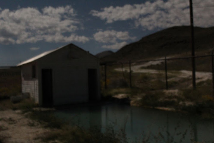
Hot springs pool! Score.
That revitalised me enough to drive the 47 miles left to Tonopah, where I filled the tank, and onwards to California where my second attempt to find a camping spot was rather successful.

Only problem was, it was 2 am and by 8 the tent was sweltering (after being freezing during the night).
After leaving Bryce, drove to Cedar Creek, passing some cool lava flow stuff, then to Cedar City where I had some tasty Mormon food and filled up on petrol. Drove to the junction with 318/375, and followed 318 instead of 375... google maps was missing a wee junction. Did a big triangle, 100 miles extra.
After driving west down 6 until it hit 375, the road I was supposed to take to get to 6, I was pretty tired (it being midnight and all), so I stopped to rest. Before I could doze off, I heard someone calling at me. I opened the window, and a kiwi wearing but a towel asked me if I was the owner. I told him I was just resting... and asked, the owner of what?
Hot springs pool! Score.
That revitalised me enough to drive the 47 miles left to Tonopah, where I filled the tank, and onwards to California where my second attempt to find a camping spot was rather successful.
Only problem was, it was 2 am and by 8 the tent was sweltering (after being freezing during the night).
Thursday Sep 27, 2012 #
trail run 1:20:00 [3] 12.9 km (6:12 / km) +523m 5:09 / km
Bryce Canyon!
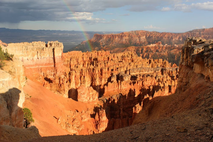
Fairyland Loop with a bit of the rim trail. ** Phenomenal **
First time running anything close to that long with a huge grin on my face the whole way. The most spectacular place I've been?
Left the camera in the car for that one.
After the run, I got food and drink, then took a couple of photos before the rain came. After the rain came rainbow, and stronger colours.
Then met a lad from Arkansas and walked the Queen's Bridge and Navajo (Wall St) loop.


Camped just outside BC, in Dixie Nat'l Forest. Soft pine needles, yay.
Fairyland Loop with a bit of the rim trail. ** Phenomenal **
First time running anything close to that long with a huge grin on my face the whole way. The most spectacular place I've been?
Left the camera in the car for that one.
After the run, I got food and drink, then took a couple of photos before the rain came. After the rain came rainbow, and stronger colours.
Then met a lad from Arkansas and walked the Queen's Bridge and Navajo (Wall St) loop.
Camped just outside BC, in Dixie Nat'l Forest. Soft pine needles, yay.
Wednesday Sep 26, 2012 #
trail run 30:00 [3]
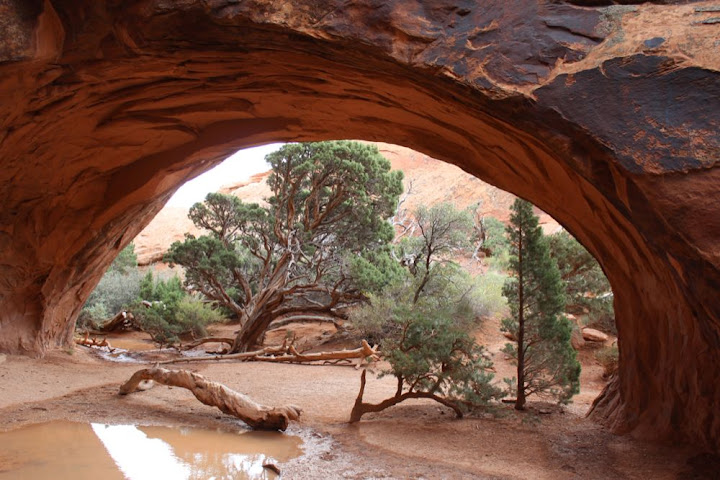
Arches!

Drove from Arches across a large part of Utah, to within 70 miles of Bryce Canyon. Found a great camping spot off of 89, maybe Cottonwood Road?

Drove from Arches across a large part of Utah, to within 70 miles of Bryce Canyon. Found a great camping spot off of 89, maybe Cottonwood Road?
Tuesday Sep 25, 2012 #
trail run 32:40 [3]
Laramie to Glenwood Springs
Colorado is pretty. But you have to be careful on the roads.
Crossed the continental divide! And said hi to the Colorado River, while it still exists -

Short trail run, partway up a hill (823m to the top, so wasn't going to be doing that today). Glenwood Springs is less pretty than some other bits, but still pretty.
Colorado is pretty. But you have to be careful on the roads.
Crossed the continental divide! And said hi to the Colorado River, while it still exists -
Short trail run, partway up a hill (823m to the top, so wasn't going to be doing that today). Glenwood Springs is less pretty than some other bits, but still pretty.
Monday Sep 24, 2012 #
Note
Wow! The Westmoreland Sanctuary map (my version copyrighted 2003) got its scales wrong. 1.5km on the map is only 1km in reality. That's insane (that it wasn't picked up on before).
I had legendary pizza last night. And my right knee is clicking a lot, I guess I should have been stretching quads and itbs more, must add them to the list.
I had legendary pizza last night. And my right knee is clicking a lot, I guess I should have been stretching quads and itbs more, must add them to the list.
orienteering 1:28:00 [3] *** 11.7 km (7:31 / km)
ahr:147 21c
Pelican Bay, Laramie
A-meet course, very slow, painfully so at times. I guess yesterday and the altitude are getting to me. Right heel was irritated. I stopped at one point to stretch the hams and the calves, and that seemed to help a little.
Mostly fine up until right before 12, where there was a fabulous view from the rocky ridge. I didn't understand the map in the circle, presume I got the 'control'. Slow plodding after that, starting to suffer. Got a little confused coming towards 18, and at 19 I paused to take a gander at the steppin stone.
Zzz.
Sunday Sep 23, 2012 #
1 PM
orienteering 40:00 [3] ***
8c
34567812 from Day 1 of Laramie Daze, at the Moose Outlet.
Only a couple of twinges from the left foot.
Only a couple of twinges from the left foot.
5 PM
orienteering 1:35:00 [3] *** 12.2 km (7:47 / km)
19c
Diamond Bay
Course from Rocky Mountain Goat 2012, with swampfox shadowing me, sort of.
Cruising. A couple of swings to 1,2 and leaving 3 and 4, all to the left... pretty clean after that, only a bit of confusion in the circle at 12 (and at 17 where the circle wasn't centred). Wonderful terrain, reminded me of some Norte Alentajo Portugese stuff, lots of fun. I could imagine doing 5.5/km in this. Imagination is wonderful.
Saw a wee herd (8-10) of elk between 17 and 18, Yay!
Extended the left foot a couple of times, but wasn't running fast.