Training Log Archive: JanetTIn the 7 days ending Aug 25, 2019:
| |||||||||||||||||||||||||||||||||||||||||||||||||||||||||||||||||||||||||||||||||||||||||||||||||||||||||
| « | » |
| » now | ||||||||||
| Mo | Tu | We | Th | Fr | Sa | Su | |||||||
Sunday Aug 25, 2019 #
8 PM
Walking 40:01 3.31 km (12:06 / km)
ahr:95 max:105
Around the neighborhood, after dinner and after having driven home from Dubois, PA (where we stayed overnight last night after the adventure run).
We detoured through the West Decatur, PA, area to check out a couple of cemeteries that are the final resting places of Glen's mom's maternal grandparents (and a great-grandfather). We found the cemetery locations through Find a Grave and Ancestry but hadn't been in the area for a long time. For one cemetery we even had a plot map I found online, making it relatively easy to find the gravestones.
We detoured through the West Decatur, PA, area to check out a couple of cemeteries that are the final resting places of Glen's mom's maternal grandparents (and a great-grandfather). We found the cemetery locations through Find a Grave and Ancestry but hadn't been in the area for a long time. For one cemetery we even had a plot map I found online, making it relatively easy to find the gravestones.
Saturday Aug 24, 2019 #
10 AM
Orienteering 5:34:21 **** 15.03 km (22:15 / km) +546m 18:49 / km
ahr:121 max:158 spiked:12/16c shoes: 2019 VJ Falcon 6.5 scot
Owww.
6-hour adventure run at Rock City State Forest (I never made it onto the other map that covered McCarty Hill SF), organized by BFLO. Forests were in NY north of Bradford, PA, where we stayed last night. Temp was near 60 when we started and after we left; it may have climbed into the mid 60s at some point. I wanted to visit the area with the biggest concentration of big rocks (and 3 controls worth 70pts) because Glen had done this event before and talked about the huge chunks of rock along a cliffy edge. I might have to look up the geology of this area.
I managed to get 370 pts and finish 3rd of 5 in the women's 6-hour (behind US WOC Team member Syd Fisher and veteran 24-hour rogainer Mary Smith).
After the climb from #37/code 121 I vowed not to do as steep a climb on any other controls (because my calves felt trashed after that climb) so I skipped 22/118 and missed on 14/120 and didn't feel like going back for it.
After the road crossing with the water stop, I took several minutes to remove my shoes and socks and add some moleskin where I was feeling incipient hot spots, knowing I still had a long way to go.
I also chose not to go to 35/115 after 21/117, because it went back down 6 contours that I would have to get back, though I might have been able to make the climb more gradual.
Order of controls (number/code, non-spikes marked with an asterisk):
3 / 103
2 / 102
8 / 124
38 / 122
37 / 121
19 / 138*
20 / 139
29 / 137
23 / 119
36 / 116
21 / 117 (counted this one as a spike because I saw the feature and flag as I approached, though I couldn't see enough detail on the map to know I had to reach the flag tucked in the middle from the downhill side)
13 / 114* (frustrated with the flag placement here too. I found the chunk of rock almost right away but the flag was again tucked underneath an overhang down a cliff from my approach)
12 / 113
26 / 131* (went to the two huge rocks with three smaller boulders first but figured out where I was)
9 / 132
1 / 101* (missed on my descent from 9; relocated from the road. Trashy woods didn't help)
Finish; "official" time was about 40 sec faster, 5:33:39
Friday Aug 23, 2019 #
Yoga 45:00 [1]
Thursday Aug 22, 2019 #
3 PM
Biking 1:05:30 9.48 km (6:55 / km) +36m 6:47 / km
ahr:122 max:161 shoes: Trek DS 3 hybrid
Jordan Parkway, exploring some new to me bike trails and disk golf fairways. Upper 80s with a slight breeze.
Lower humidity, it seemed, than it's been.
Lower humidity, it seemed, than it's been.
Tuesday Aug 20, 2019 #
10 AM
Hiking 52:25 3.45 km (15:11 / km) +79m 13:38 / km
ahr:100 max:143 shoes: Sauc TriumphISO-silver/gr/blue
Hiked trails on Star Village map near Lehigh Univ while Glen ran them. About 81F but lots of shade.
Lots of emerging Spotted Lanternflies hopped off the trail on my approach. I nailed a few, but most got away. Then there was this...disgusting.
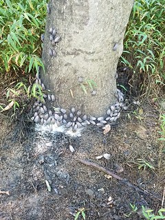
Lots of emerging Spotted Lanternflies hopped off the trail on my approach. I nailed a few, but most got away. Then there was this...disgusting.
5 PM
Yoga (Vinyasa) 45:00 [1]
Stretching, mostly, plus lots of balance
Monday Aug 19, 2019 #
Yoga 50:00 [1]
Focus: neck and upper back