Training Log Archive: vmeyerIn the 31 days ending May 31, 2009:
| |||||||||||||||||||||||||||||||||||||||||||||||||||||||||||||||||||||||||||||||||||||||||||||||||||||||||
| « | » |
| » now | ||||||||||||||||||||||||||||||||||||
| Fr | Sa | Su | Mo | Tu | We | Th | Fr | Sa | Su | Mo | Tu | We | Th | Fr | Sa | Su | Mo | Tu | We | Th | Fr | Sa | Su | Mo | Tu | We | Th | Fr | Sa | Su | |||||||||
Sunday May 31, 2009 #
Note
Trail Run (Fountainhead) 28:30 [2] 2.0 mi (14:15 / mi)
shoes: Salomom XT Wings 10
So, out 1 mile and back (14:55 and 13:35). Temps at 75 F. Trail nice and muddy in parts, especially with the earlier traffic. Lungs struggling going out, but they were comfortable on the return trip. Blistered part of feet good, though I have a sharp pain on the top of my right forefoot.
Thursday May 28, 2009 #
Note
weight:189lbs
Would probably have tried a walk after work today, but the humidity was horrible, so I didn't. Easy to take another day of rest time.
Wednesday May 27, 2009 #
Note
slept:8.0 weight:191lbs
The RoyalTek is a good choice because it is small, and it uses two AA batteries which can be swapped out easily. The battery life is claimed to be 10 hours, so I swapped them at ~8 hours.
Besides a couple of points which had us out in the Atlantic Ocean or up in New York state, and were easily deleted in a text editor, the tracks were excellent.
Tuesday May 26, 2009 #
Note
slept:8.0 weight:190lbs
Two days post event:
Plenty of oozing mosquito bites on my upper arms. Little small bites, not the large spots I usually get at home.
Feet have mostly stopped seeping.
Diaper rash has mostly cleared up.
No ticks (so far, knock on wood) except the huge one I pulled out of my hair at control #33.
Legs blend into feet - swollen, no definition.
To be expected - still mostly pooped, but not so sore.
Sunday May 24, 2009 #
Rogaine race (SVO Rogaine Part 2) 9:10:00 [3] *** 16.3 mi (33:45 / mi)
shoes: Ice Bugs - Green
Control 12 - #82 on the O Map: split 0:33 (1.1 m), total 9:51 (21.3 m)
2 Clamoring Old Orienteering Ladies
So, back to where I left off. We are on are way from 72-82, it is totally dark, and we are in a crappy stream bed on a part of the O map which was not field checked. I was quaking in my boots. I went from leading with my good light (Ay-Up from Australia) to cowering in the rear, feeling very overwhelmed and vulnerable. But, despite my apprehension, I was so very confident in Sandy, that I shut out the bad thoughts since I just knew she would get us out of there. And, she did! It was very impressive. What was even more remarkable was the fact that she guided us around the private property which we encountered along the way and into the control with barely a hiccup. If it was me, I would still be sitting there at the last control waiting to be rescued.
Control 13 - #40 on the O Map: split 0:44 (1.6 m) plus break 0:15, total 10:50 (22.9 m)
2 Congenial Old Orienteering Ladies
Out to the road and a long uphill haul on the pavement to the water stop. There were reflective markers on the road, so I would key on reaching the next one. Really disappointed when there wasn't one for a longer stretch. Reached the pond, and then the control location at the stream junction. Very soothing and picturesque. Just imagine the pretty picture it would have been, if I had remembered to take a picture.
We stopped here and refilled for what would be the last time, and I probably did something to my feet.
Control 14 - #25: split 2:13 (3.8 m) includes 30 minutes of breaks between the two controls, total 13:03 (26.7 m)
2 Collaborative Old Orienteering Ladies
So, throughout the day, Sandy had been spying these tiny little brown tree frogs, which I couldn't see for the life of me. However, she did not see the rattlesnake on the trail. She stepped right over it! I was behind and my light caught it, so I pointed it out to Sandy as I moved 10' away from it. Then, I decided that I needed a picture. It was moving off into the underbrush, but I got off three shots, and turned up the trail. At that point, it started rattling VERY loudly and making a moving sound. So, Sandy and I made tracks as well. It was much bigger then it looks in the picture.

After the snake excitement (and there was a smaller one in the road later on), we hit the hard packed dirt road, and we took a break. I tried taping some moleskin to the heels and changing my socks. I also swapped my custom inserts for the thinner inserts which came with my shoes. While we were sitting here, the first of numerous vehicles came by. Two guys in a Jeep stopped and asked if we were OK, and maybe asked if we needed anything. We assured them that we were fine, and they drove off. I lamented the rest of the night not asking if they had a cold one.
Not long after, a second vehicle came by, three younger, more punk guys, slowing down, looking, but not stopping. That one was more creepy/scary.
When it was quiet again, Sandy tried stretching the muscles in her lower back/butt since that area was really painful. After about 20 minutes, we got up, and I took about 10 steps and realized that the taping on the left foot was too tight to flex my foot. So, we stopped again so that I could remove it, and off we went.
Approaching the control area, still using the O map to get to the vicinity, Sandy commented that the control was probably in where the tire tracks on the side of the road were. We actually, went in a bit further down the road, and missed the control, and spent about 25 bonus minutes in the blueberry. Once back at the road, Sandy solicited my opinion on whether we should try again for the control. It was only 25 points, but I had really never considered the point total when we started out. They were all hard to me, so giving it another try was called for. We go back up the road, in again, and somewhat nail it. Yeah for us!
Control 15 - #60: split 0:31 (1.1 m), total (13:34 (27.8 m)
2 Certain Old Orienteering Ladies
These one just seemed so easy. Sandy used the O map to get us somewhat close, and then some through the blueberries to the clearing. Probably the only time Sandy crabbed about the control location.
Control #16 - #32: split 0:48 (1.6 m) plus break 0:25, total 14:47 (29.4 m)
2 Chirpy Old Orienteering Ladies
The route was down the hard packed road again, and my feet were really unhappy, but Sandy took us into the control location flawlessly. I liked this control location. Well, not the part about the control being on top of some rocks, but it was a nice place to sit and rest and watch Sandy go up and get the control.
I made my last ditch effort to get my feet comfortable by putting back on my original socks (Smartwool for running) and changing back to the custom inserts which had much more padding then the thin ones. The only problem with the custom ones was I think it they were rubbing my feet all of the way around. But without them, walking on the road felt like I was walking on pavement with nothing on my feet.
Control 17 - #45: split 1:25 (2.8 m), total 16:12 (32.2 m)
2 Conceded Old Orienteering Ladies
Still in the dark, and just a slight pull to right, and we climbed up the spur and the saddle was to the left, but we went to the right. About 15 minutes of error, followed by the moment of truth. We were going further west, or we were going to the finish. I needed to head in. My feet were toast. So, with a plan for one more control on the way in, the decision was made without making me feel any worst then I already did.
Control 18 - #53: split 1:08 (2 m), total 17:20 (34.2 m)
2 Creaky Old Orienteering Ladies
Sandy nails a final control while expertly skirting us around a last bit of private property.
Finish: split 2:08 (2.3 m), total 18:28 (36.5 m)
2 Cool Old Orienteering Ladies
A long march down Route 233 - brutal! Glad it was not 11 AM, and we needed to do this in a hurry. It was tough. But, we made it. The first ones to officially hand in our control card and get scored, but we were good with that.

I immediately had a cold hot dog and headed to the car. At 6:45 AM, the dip in the lake didn't seem all that appealing after all, so I found a shower instead.
This was such a great experience. We both wanted to do well, but we also stopped and smelled the flowers (figuratively at least).

We finished 1st Female team of just two teams, but you can't underestimate Judith and Nadadza, so the outcome was in doubt until they checked in. We also finished 8 of 18 teams, and some of those teams we beat are probably kicking themselves about it.
It was obvious that sometime in the night that I had given up all pretense of following along, if I had been at all.

Good thing Sandy was nailing everything, albeit with a couple of hiccups. Less then an hour of error time on these maps is truly amazing to me, especially with the fact that Sandy did 100% of the navigating. Being on for the whole time could not have been easy.
I have to thank Sandy for taking me on. And, though I can't believe I am saying this, I would be willing to give it another try, if the right opportunity comes along, and she is game.
Thanks also to SVO - Marliee (registrar), Mike, Eddie, Brad, and Dave for control hanging, and especially to Julie and Eddie the Fluffy Man who fed us well when we were done.

Saturday May 23, 2009 #
Rogaine race (SVO Rogaine) 9:19:00 [3] *** 20.2 mi (27:40 / mi)
shoes: Ice Bugs - Green
Back about 8-10 years, when I was younger and stupider, I had it in my mind that I would add a 24 hour Rogaine to my resume. You got to try it once, right? I trained for some 50K trail runs, and I figured that I maybe could make the jump to the longer orienteering event. However, lack of confidence in my ability to pull it off meant that I never seriously looked for a partner. In the meantime, I tried an 8 and 12 hour Rogaine, and I was pretty sure that I could live without trying a 24 hours. Along the way, I got older and fatter, though not smarter.
So, sometime in the last year, and I am not sure how, Sandy and I decided to partner up for the Rogaine in 2009, and the SVO event was the best fit. Partnering up with someone as experienced as Sandy was both reassuring and intimidating.
In anticipation of the event, Sandy and I did some long training outings in January-March. These went well in terms of partner dynamics, and I gained some confidence that I could be a good teammate, especially since Sandy was happy to make and execute the navigational decisions, and I was happy to go along for the ride. Besides learning that we could get along for long periods, I was reminded again that my feet are my weakest link.
I tried some different shoe, sock, and insert combinations, but I still get blisters, even for shorter workouts. And since my training in April and May has been little or non-existence, between my feeling unfit and my feet, I started to have major doubts about doing this event just a few days before. I almost called the whole thing off.
Fortunately, I can overcome my lack of confidence, if not my tender feet. The related blister and toe issues are harder to control. Example of how my feet looked, and this was before the start.

Prologue
I drove up the morning of the event since it was only 2.5 hours away, and I knew I would get better rest at home, and I did. Met Sandy at the Pine Grove Furnace shelter/Hash House around 9:30, and signed in as 2 COOL (2 Cranky Old Orienteering Ladies). Then we moved our cars over to the parking area by the lake. I put on my Ice Bugs, and we walked to the shelter to chat (about .25 mile of pavement each way). Then we walked back to the car. I mention this because I wanted to see how the shoes, socks, and inserts would feel. All felt fine.
Packed the rest of my pack and decided not to take a second pair of shoes with me, but I did take five pairs of socks. I also carried two bladders (70 oz Gatorade and 100 oz water), two 20 oz bottles, Vaseline, wipes, long sleeve shirt, jacket in a pouch, lots of GU, headlamp, handheld flashlight, and a whole bunch of other stuff, including a walking stick, which proved to be invaluable.
Walked back to the shelter for the control card/maps and race brief.

Brad Whitmore doing the race brief with Peggy and Nadim listening intently.

The race map (the "Before" picture) - 1:30,000

Back to the car again for the route planning. Besides the overall map, we were also given, and allowed to use, orienteering maps of the area. Sandy devised a plan.

And then back to the start, which we actually missed by 10 minutes, to the delight of the meet crew who would have never expected it of us. I guess we looked laid back enough that someone started asking Sandy questions about her recent vacation.
Stopped for a team photo courtesy of Julie Keim.

After I stopped for a last stop at the bathroom and went back to the shelter for my forgotten map, we were off on to out first control - right by the car again. Since we hadn't seen the start of the race, it was really unclear which way people had gone.
I carried a GPS data tracker (no screen) and here is our route in QuickRoute. Thanks for all your hard work on QuickRoute, Mats!
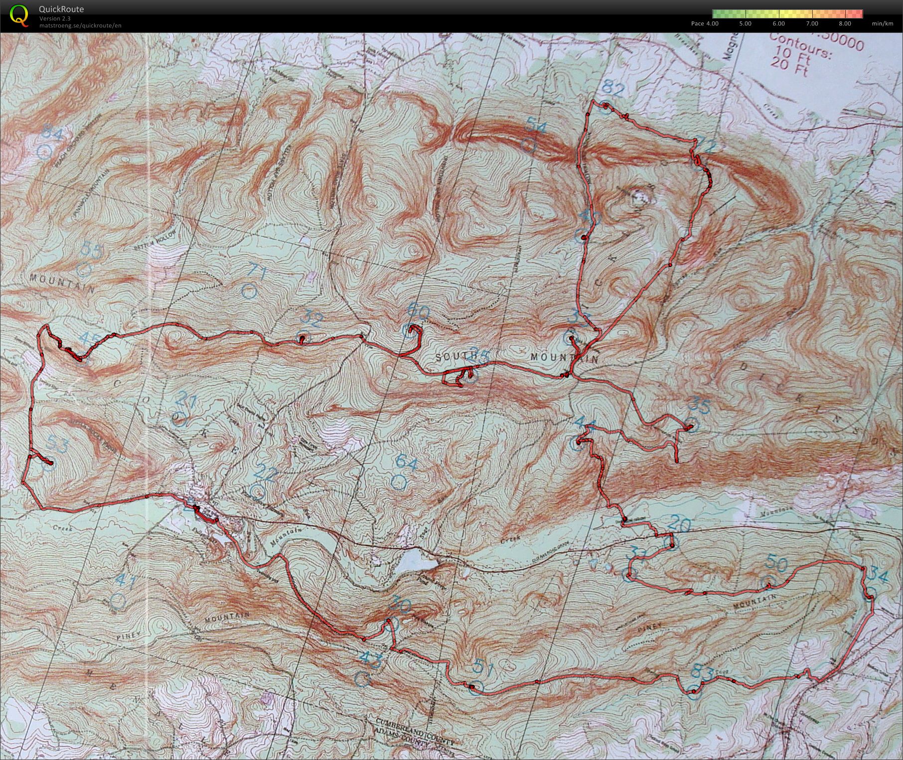
Control 1 - #30 on O map: split 0:54 (2.6 miles), total 0:54 (2.6 miles)
2 Compatible Old Orienteering Ladies
Left the parking lot via Fuller Lake, which I had visions of jumping in after we were finished in 24 hours. Eventually got on the Appalachian Trail, and it was along this section that we saw the majority of people we would see while we were in this section of the map, none of them doing the Rogaine.

Sandy nailed the control (a common theme throughout the event). We were the first ones to sign in at this control; though we weren't really surprised since other teams going this way may have been picking up 41 and 43 out of the start.
Control 2 - #51: split 0:32 (1.3 m), total 1:26 (3.9 m)
2 Confident Old Orienteering Ladies
First to this control as well. If I remember correctly, the AT had changed on the way to this control, but Sandy read the contours well, and took us right to it.

Control 3 - #83: split 0:50 (2.2 m), total 2:16 (6.1 m)
2 Clumsy Old Orienteering Ladies
AT to where it hit the stream, then crossed the stream to the control.

First to sign in here as well. I think this is the control where I fell and smacked my right leg pretty good, including a puncture wound to the upper shin. It was pretty small but bleeding down my leg, so I stopped and taped a pad of tissue to it. It must have helped to support my knee at the same time, because after that, the knee pain lessened, and today (Monday), my knee is pain free.
Control 4 - #34: split 1:00 (2.3 m), total 3:16 (8.4 m)
2 Chagrined Old Orienteering Ladies
Started seeing Private Property signs out of #83, so we were a bit wary. Though not wary enough to avoid walking up someone's driveway to the road. Oops. Luckily, the barking dog was inside. Took the stream to the road, and the road to the train tracks, and then in from there. First again to sign in. Now, we are really starting to wonder where everyone has gone to!
Control 5 - #50: split 0:35 (1.3 m), total 3:51 (9.7 m)
2 Cheeky Old Orienteering Ladies
Another AT reroute which Sandy handled beautifully, and, finally, a sign in board which we weren't first to. However, the signer was an AT hiker who had signed in earlier in the day with his next destination listed as Maine. Too funny. I wish I had gotten a picture of that!
[Edit: from dlevine's log: Hanging flags for the Michaux Rogaine (SVO) after an overnight with Mike Ball. We did a team-based two-car hanging, getting a chance to hike a good bit of the AT while doing so. Did have one interesting moment while on the AT. The hill we were looking for (#50) should have been to our right (according to an old USGS map that had the AT labeled). My very rough pace count had us "there" but there was a hill to our left and very much not to our right. Climbed that hill to find the streamer. Turns out the AT has been relocated over the years (no surprise there) by about 100m and that control falls between the two locations. Wonder how many people got screwed up by that?]
Control 6 - #31: split 0:37 (1.5 m), total 4:28 (11.2 m)
2 Crafty Old Orienteering Ladies
Finally, another team comes up behind us.

PGH Hashers has been stalking us for a while, so we were pretty sure our reign as first team on the sign in list was over. After chatting for a couple of minutes, they went off briskly ahead of us. However, they went the wrong way at the trail junction and stayed on the AT, whereas Sandy realized quickly that we shouldn't be heading that way, and got us turned around, finding the correct trail which was covered at the trailhead. And, to make it even sweeter, we ended up on a trail all of the way into the control. He He! Sorry guys. Life was good!
Control 7 - #20: split 0:15 (0.6 m) plus break 0:10, total 4:53 (11.8 m)
2 Chortling Old Orienteering Ladies
Water control near Route 233. Coming out of the control were the Lyons who were coming onto this map from the other side of the road. I reapplied Vaseline to my feet here, and I think I changed my socks. Probably a major error, since I didn't have the same style socks to put back on. Couldn't sit still for long since the mosquitoes were biting mad.
The PGH Hashers caught back up to us as we were heading out of here.
Control 8 - #44 on O Map: split 1:10 (2.1 m) plus break at creek (0:10), total 6:03 (13.0 m)
2 Creeky Old Orienteering Ladies
Crossed the road and started looking for a place to go through to get onto the trail between the private properties. A guy called up from his driveway asking if we were looking for the trail. Thinking that he wanted to point us to the AT, I tried to wave him off, but Sandy wisely let him talk, and he was very friendly. So, we asked permission to go through his yard to the trail, and he granted it.
There were two creeks to cross before we got to climb the mountain. We crossed the first one on this metal beam thing.

For the second one, we took off our shoes and socks, and walked across. This was unbelievably painful on the feet, though the water felt good. Here is my two part self portrait.


Should have taken my pill case out of my back pocket before sitting in the creek. Though my BP medication dissolved, the liquid gel Advil stayed intact, and I continued taking two every three hours or so.
The hike up the hill from the creeks was brutal, and once we were out of the shade, it became really uncomfortable, but we made it. And despite, the change in the look of the land due to logging, Sandy led us into the control with little difficulty.

Met two teams here, including the one with the dog.

The other team we meet here was low on water, so I gave him a 20 oz Gatorade bottle which I had filled with water at #20. He didn't want to take it, but his partner wisely agreed to. I assured them I was fine since I had two full bladders, and I knew Sandy would get us to the next water control as promised.
Control 9 - #35 on O Map: split 0:53 (1.7 m), total 6:56 (15.6 m)
2 Cocky Old Orienteering Ladies
So, maybe I jinxed Sandy just a tiny bit...we had our first bit of error time on this control - about 8 minutes when we missed seeing the (now indistinct) trail which we had planned to turn onto. Cost us a bit of climb to get back up to where we should have turned in. What was impressive was Sandy's ability to interpret where we had ended up and get us back on track so quickly.
Ran into PGH Hashers again on the way to this control. We were heading in the opposite direction at this point. Alexis told me that he had left us a note. We got a chuckle out of it.

Control 10 - #33 on O Map: split 0:41 (1.7 m) plus break 0:20 , total 7:57 (17.3 m)
2 Climbing Old Orienteering Ladies
All trail leg to this control, though it seemed like the uphill would go on forever. I guess I was ready for a break. Stopped here and got ready for the night. The plan all along was to stay out and only come in when I (my feet) had had enough.
Well, I had one good blister on the side of my right foot by now, and others developing everywhere else, so I slathered more Vaseline on starting wondering how long I would be able to go.
Control 11 - #72 on O Map: split 1:21 (2.9 m), total 9:19 (20.2 m)
2 Creepy Old Orienteering Ladies
Edit from Sandy: the route to #72 was a long, long downhill trail march. The only memorable thing about it was that a couple of the trail junctions were very indistinct so having the O map to stay on top of what the terrain should have been doing was key. Sandy almost made the error of pacing for the USGS map instead of the O map on the last little bit, but caught that right as we got close.
Truly dark now, and after finding this control, we were heading to the one place we didn't want to be in the dark - on the part of the O Map which was not field checked. Additionally, we were coming from a control on a creek. Brad had warned us that the creek beds could be very thick.
I was really apprehensive, scared, spooked, and lots of other adjectives as well, coming out of this control. It was all so close, and creepy, and there were trees with thorns growing out of the trunk, one of which I managed to grab hold of.
I think I would have quit right there if we had been closer to civilization.
To be continued...including the rattle snake picture.
Thursday May 21, 2009 #
Note
Wednesday May 20, 2009 #
Mowing/Yard (Mow lawn) 10:00 [0]
Sunday May 17, 2009 #
Note
Orienteering race (Buffalo Green Y Long) 1:18:07 [3] *** 6.0 km (13:01 / km) +135m 11:42 / km
shoes: Icebugs Sky Blue
I would have to say this was my most perfect run ever (maybe 1 minute total error, though WS says 0), and if I had been in better shape, that would have made it even better, though I am not complaining. I finished before any other starters, even those speedy White runners, and was visibly excited - despite the long run across the field to the GO control - probably my only nitpick of the weekend.
During the course, I restrained myself from looking at my watch and wondering how long I had been out. I was nailing things, and though some would say this was a runner's course, I wasn't running very much, and, it was fraught with the kind of legs that I totally screw up on a regular basis- like not being able to go straight between two trails.
Got back to find Nancy helping Doug out, and I was very appreciative to have a chance to change because today was cold - just perfect for me.
Buffalo did such a great job on this event, and if I have some time tomorrow, I will expound on it, but if I never get back to the topic, then the best thing was that they assigned someone to personally make a bag lunch for me yesterday. :) Feed me and I will keep working for nothing. :)
Saturday May 16, 2009 #
Note
Orienteering race (Buffalo Green Y) 1:00:05 [3] *** 3.1 km (19:23 / km) +125m 16:08 / km
shoes: Icebugs Sky Blue
Orienteering race (Buffalo Sprint 2) 18:39 [3] *** 2.2 km (8:29 / km) +35m 7:51 / km
shoes: Icebugs Sky Blue
WS says no errors, just ran out of steam.
Two nice conversations with Hannah B (who had some good runs), as well as some people after the dinner.
Good day despite the weather issue - more wind than rain.
Sunday May 10, 2009 #
Rogaine (Carderock) 55:00 [1] 3.5 mi (15:43 / mi)
But, the shoe/sock combination sucked. I was trying a different pair of IB which have a wider toe box. That part was good. However, the tongue is one piece, and it was cutting into my foot with the inserts in. Oh, joy, another tender foot part.
So, I turned around after a few minutes and swapped out to the insoles which came with the shoe. Now, this would have been fine if I had some more socks to layer in to take up some of the room in the shoe, but I didn't. I had traveled very light this morning.
I was to meet someone there to pick up meet supplies at 10, so I needed to do something for an hour+, thus (tired of using "so" so much) I headed out in my, now, too loose shoes. But, it was a lovely spring day, and life was good.
Saturday May 9, 2009 #
Rogaine (PWNF) 2:09:00 [2] 7.5 mi (17:12 / mi)
shoes: Ice Bugs - Green
Wore my insert that are more cushy and built up in the heel cup to try to relieve pressure on the Achilles tendon. Arch painful for first 15 minutes, and then settled down and no noticeable pain there after that. Left bunion a little painful. I also got a huge blood blister on my right second toe, and a smaller one on the same toe on the left foot.
I was wearing three thin pairs of socks, and that may have been too much in the toe box. Will try other shoes tomorrow (3 hour hike on the C&O?) and a different pair of shoes.
Did not run a step.
Sunday May 3, 2009 #
Orienteering race (Lake Accotink Orange) 47:27 [3] *** 3.3 km (14:23 / km)
shoes: Ice Bugs - Green
Turned my right ankle over to the outside near the 6 or 7.
Glad I got something in.