Training Log Archive: CleverSkyIn the 7 days ending Jul 22, 2017:
| ||||||||||||||||||||||||||||||||||||||||
| « | » |
| » now | ||||||||||
| Su | Mo | Tu | We | Th | Fr | Sa | |||||||
Wednesday Jul 19, 2017 #
Note
(injured) (sick)
Thoughts on the Western Canadians (tl;dr)...
The courses: OK, but could have been better, in my book. There are folks who are really advocates of the notion that Sprint, Middle, and Long should have different "character". These did not, which doesn't bother me so much. Yeah, the longest leg on the Long was nearly as long as the entire Sprint course, but that's because there was more to work with on that course, and the longest leg on the Middle was almost as long the second-longest on the Long. All three courses were a mix of long and short legs, "regular" orienteering. I think there was opportunity, though, to make the Sprint, at least, rather different, a bunch of short legs in an area that was mostly open (or with just well-defined green blobs), and the last part of the course was indeed like that.
All three (for my course, and also the M21 course) ended with an extra loop of short legs. That would have been fine if the controls had all been in pleasant terrain, but on the last day, we ended up with going through some crud at the end, which leaves the competitors with a bad taste in their mouths. You should always finish up with the most pleasant terrain. And in general, there was a related issue regarding control placement. Maybe they were mostly good, but they should have all been nice. The challenge in this terrain is keeping track of where you are, and there's no need to have the control hidden when you finally get to your destination. Small clearings inside of green areas are unnecessary. If I were setting courses in a place like this, I'd be tempted to put the controls all on top of hills where they'd be easy to spot. There were few enough people in attendance that Steve Tarry's rule about pits wasn't much of a factor, that being that it's inherently unfair to put a control in a pit such that the feature and control are invisible unless there's an orienteer standing there punching. Ignoring that, of the 40 controls that I had, I'd say 11 of them were needlessly hidden in green stuff (maybe more, I'm having trouble remembering what a couple of the placements looked like).
The courses were probably too long, and the course setter admits that. He says he didn't have an accurate sense of the caliber of competitors who were expected, and that may be so. Maybe some was also the desire to use a decent amount of this large map, but I can't know what was going on in the setter's head. Initially the courses were even longer; Course 10 was reduced from 15 km to 12.5. But this was terrain where only four elite men on the Sprint and two on the Long managed to break 10 min/km. It's too technical to be fast. An illustrative point is that on my 8.5 km Long course, my GPS track is 14 km. A bit of that is the extra loop that I did looking for #1, but it's clearly the case that you're going to do extra distance in these dunes, be it from a wide route choice, or from the myriad little wiggles that are necessary on the "straight" line. It's also far from flat. They listed climb on the courses, though that's not overly meaningful, because routes are so hard to predict, and since the climb all comes in tiny ups and downs, it's very hard to count. Their numbers might be about accurate, who knows? Climb here is almost not a consideration, you can't set courses to be more or less steep, and as a competitor, it comes into play only in micro route choices.
(Slightly comical, but harmless, was the fact that they had a full-blown three line start process (with the lines maybe 5 m apart), a punching start, plus a remote start triangle, all for 57 registered competitors, and a start window that was less then 40 minutes long even with a three-minute start interval.)
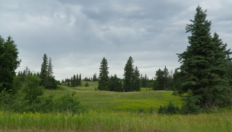
The vegetation: I've been known to say that sandhills are as good as it gets, in terms of technical challenge. The first time I encountered them was in the Canadian Champs in 1992, in Hartney, MB. I don't remember there being as much poison ivy there (any?). Actually, looking at my map, I don't think my memories of that place are accurate at all, so it's hard to compare. I went to Spruce Woods four years ago, to the Hog's Back map, and that was similar to this place (unsurprising, since the two areas are almost adjacent). I remember a lot of poison ivy, but maybe not as much as this weekend. (Maybe it has flourished all over in the past few years.) Since I had that knowledge, I showed up prepared, and dealt with it pretty successfully. I'm not overly sensitive to poison ivy, I usually just get patches of rash on the sides of my heels (no matter what the circumstances of exposure), and that's what happened here -- I judge it a mild case. That was with extreme exposure followed by reasonable caution and cleaning. It was really remarkable how much of it was out there, I'd use it as a canonical example of the word "ubiquitous". On the long course, I noticed a couple of times when I was not standing in poison ivy, and it struck me as odd. The organizers did provide a big tank of water for washing, which was great (maybe they have to do this at every meet?). The only place I can remember having encountered more poison ivy is World's End, a small park map in Hingham MA that I think was used only twice, and there was no reason to leave the trails. I recall less of the stuff at the notorious Ganaraska.
The map: um... yeah. This is my fourth time in Canadian sandhills; in addition to the ones mentioned above, I also went to the Canadians in Saskatchewan in 2007. The terrain is all sandhills, and in the case of Hog's Back and Cypress River, the maps are within walking distance of each other. But there has been a change in the mapping. Compare the following map samples (all adjusted to the same scale):
Fort Desjarlais, MB, 1992
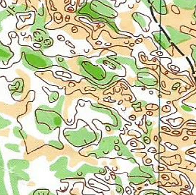
Eb's Trails, SK, 2007

Hog's Back, MB, 2013
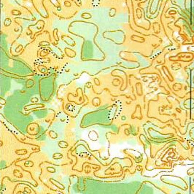
Cypress River Sand Hills, MB, 2017
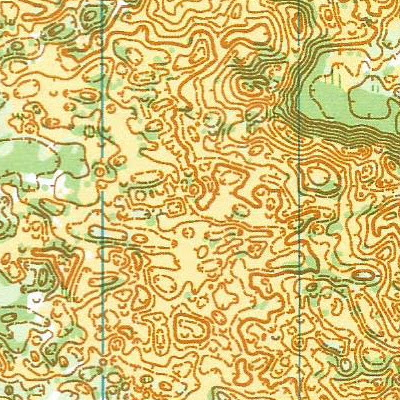
So what's going on here? Well, the first two are more subtle terrain, all of the features are pretty low, and the contour interval is 2.5 m. The last two are in Spruce Woods Provincial Park, where the features are taller, and for Hog's Back, they opted to use 5 m contours, which seems to capture about the same amount of detail. But for Cypress River, they went back to 2.5 m contours, and this one may be the first use of LiDAR as well. 2.5 m contours with quite a few form lines. It's as if the mapper hated the idea of paper that didn't have brown ink on it, and just kept adding spaghetti until there wasn't any left. A lot of this probably came from the LiDAR, but it's pretty easy to tweak a computer algorithm to just keep adding stuff (moreso than a human photogrammetrist, who would have had to draw it). A lot of the area depicted in that map sample is basically a flat open field. And that's a problem. We're used to distinguishing between flat and steep areas by how far apart the lines are, but when the flat areas get filled up with superfluous brown ink, then everything looks alike. Charlie and I both noted times when we were looking at either a flat field, or a steep slope, and couldn't find such things on the map. Orienteering obviously happened in the past on the old maps, and my opinion is that it's counterproductive to make the map so busy as to be unreadable. Yes, the detail is all there, but a lot of it is not useful to me. Small depressions are about the size of my cubicle at work, and half as deep. Do I care? Particularly when these features are jammed together so tightly that I sometimes can't even parse them. The 1:10000 maps for Middle and Long on my course were at the limits of legibility. I joked that I'd like to see what this map would look like printed at 1:15000, but I'lll note that in 1992 and 2013, I was using 1:15000 maps of this stuff. Also, the printing on the Middle course was quite good, but the printing on my Long map was decidedly substandard.
My experience: This is a fine example of "be careful what you wish for, you might get it". It was my own decision to run up two categories (I ran M35, but I'm 56, and the categories in Canada are 10 years) because I wanted to get my money's worth if I was going to travel all that way. Nearly six hours of intense orienteering in two days, so no complaints there. I can't really complain about the poison ivy because I knew it was there, and two days later I have no residual symptoms. It was definitely hot, and I should have brought a hat or bandana, because the salt in my eyes was really bad, they were burning by the end of the Middle and Long courses, making it really hard to read the map. I had a painful problem with my right knee, which was something of a handicap, but which helped me keep from running, an essential move. There were a lot of bugs, too, of all sorts: a few mosquitoes, a lot of dragonfiles, quite a few large regular flies, one grasshopper, and Charlie found several ticks, though I found none, and in the parking area, some ants were biting my feet. None of the others were really a problem in terms of biting, but it was annoying having them buzzing around my head while I was on the course, and I think the rental car agency had some work to do.
(The windshield was no better.)
Would I go back? Good question. I was working pretty hard while I was there to leave myself mental notes to not return, I was pretty convinced that I was done with Manitoba. I may well be done with Spruce Woods, because the poison ivy threat is just not worth it, but for other places that are relatively free from it, if I had the right traveling companions, I might consider it. But there's more than just that. This was hard. Maybe too hard. The locals are used to this stuff, so they're at an advantage, and that's fine. I managed to soldier through and finish (and even "won"), but it was at the limits of what I could handle in terms of concentration. This was orienteering without a net; there were a substantial number of DNFs, and I suspect that most of those were people who made a small error that compounded itself and rapidly spiraled out of control. Normally in a situation like that, you relocate, but in the belly of this map, there's no way to do that, and you're just busted. Out of the general populace, there's only a small percentage that would consider it "fun" to go out in the wooods with a map and find their way around looking for controls. Out of that group, the orienteers, I think there's also only a certain percentage who would consider this past weekend fun. Maybe like some kind of powerful exotic whiskey, which is nectar to the aficionados, but you couldn't convince others that it tastes good at all.
Oh, and there was cheat grass. I almost forgot to mention the #&!@% cheat grass. Hard to maintain concentration and focus when you have to keep stopping to pull cruise needles out of your socks. If I ever go back, I need to remember to bring gaiters.
The courses: OK, but could have been better, in my book. There are folks who are really advocates of the notion that Sprint, Middle, and Long should have different "character". These did not, which doesn't bother me so much. Yeah, the longest leg on the Long was nearly as long as the entire Sprint course, but that's because there was more to work with on that course, and the longest leg on the Middle was almost as long the second-longest on the Long. All three courses were a mix of long and short legs, "regular" orienteering. I think there was opportunity, though, to make the Sprint, at least, rather different, a bunch of short legs in an area that was mostly open (or with just well-defined green blobs), and the last part of the course was indeed like that.
All three (for my course, and also the M21 course) ended with an extra loop of short legs. That would have been fine if the controls had all been in pleasant terrain, but on the last day, we ended up with going through some crud at the end, which leaves the competitors with a bad taste in their mouths. You should always finish up with the most pleasant terrain. And in general, there was a related issue regarding control placement. Maybe they were mostly good, but they should have all been nice. The challenge in this terrain is keeping track of where you are, and there's no need to have the control hidden when you finally get to your destination. Small clearings inside of green areas are unnecessary. If I were setting courses in a place like this, I'd be tempted to put the controls all on top of hills where they'd be easy to spot. There were few enough people in attendance that Steve Tarry's rule about pits wasn't much of a factor, that being that it's inherently unfair to put a control in a pit such that the feature and control are invisible unless there's an orienteer standing there punching. Ignoring that, of the 40 controls that I had, I'd say 11 of them were needlessly hidden in green stuff (maybe more, I'm having trouble remembering what a couple of the placements looked like).
The courses were probably too long, and the course setter admits that. He says he didn't have an accurate sense of the caliber of competitors who were expected, and that may be so. Maybe some was also the desire to use a decent amount of this large map, but I can't know what was going on in the setter's head. Initially the courses were even longer; Course 10 was reduced from 15 km to 12.5. But this was terrain where only four elite men on the Sprint and two on the Long managed to break 10 min/km. It's too technical to be fast. An illustrative point is that on my 8.5 km Long course, my GPS track is 14 km. A bit of that is the extra loop that I did looking for #1, but it's clearly the case that you're going to do extra distance in these dunes, be it from a wide route choice, or from the myriad little wiggles that are necessary on the "straight" line. It's also far from flat. They listed climb on the courses, though that's not overly meaningful, because routes are so hard to predict, and since the climb all comes in tiny ups and downs, it's very hard to count. Their numbers might be about accurate, who knows? Climb here is almost not a consideration, you can't set courses to be more or less steep, and as a competitor, it comes into play only in micro route choices.
(Slightly comical, but harmless, was the fact that they had a full-blown three line start process (with the lines maybe 5 m apart), a punching start, plus a remote start triangle, all for 57 registered competitors, and a start window that was less then 40 minutes long even with a three-minute start interval.)
The vegetation: I've been known to say that sandhills are as good as it gets, in terms of technical challenge. The first time I encountered them was in the Canadian Champs in 1992, in Hartney, MB. I don't remember there being as much poison ivy there (any?). Actually, looking at my map, I don't think my memories of that place are accurate at all, so it's hard to compare. I went to Spruce Woods four years ago, to the Hog's Back map, and that was similar to this place (unsurprising, since the two areas are almost adjacent). I remember a lot of poison ivy, but maybe not as much as this weekend. (Maybe it has flourished all over in the past few years.) Since I had that knowledge, I showed up prepared, and dealt with it pretty successfully. I'm not overly sensitive to poison ivy, I usually just get patches of rash on the sides of my heels (no matter what the circumstances of exposure), and that's what happened here -- I judge it a mild case. That was with extreme exposure followed by reasonable caution and cleaning. It was really remarkable how much of it was out there, I'd use it as a canonical example of the word "ubiquitous". On the long course, I noticed a couple of times when I was not standing in poison ivy, and it struck me as odd. The organizers did provide a big tank of water for washing, which was great (maybe they have to do this at every meet?). The only place I can remember having encountered more poison ivy is World's End, a small park map in Hingham MA that I think was used only twice, and there was no reason to leave the trails. I recall less of the stuff at the notorious Ganaraska.
The map: um... yeah. This is my fourth time in Canadian sandhills; in addition to the ones mentioned above, I also went to the Canadians in Saskatchewan in 2007. The terrain is all sandhills, and in the case of Hog's Back and Cypress River, the maps are within walking distance of each other. But there has been a change in the mapping. Compare the following map samples (all adjusted to the same scale):
Fort Desjarlais, MB, 1992
Eb's Trails, SK, 2007
Hog's Back, MB, 2013
Cypress River Sand Hills, MB, 2017
So what's going on here? Well, the first two are more subtle terrain, all of the features are pretty low, and the contour interval is 2.5 m. The last two are in Spruce Woods Provincial Park, where the features are taller, and for Hog's Back, they opted to use 5 m contours, which seems to capture about the same amount of detail. But for Cypress River, they went back to 2.5 m contours, and this one may be the first use of LiDAR as well. 2.5 m contours with quite a few form lines. It's as if the mapper hated the idea of paper that didn't have brown ink on it, and just kept adding spaghetti until there wasn't any left. A lot of this probably came from the LiDAR, but it's pretty easy to tweak a computer algorithm to just keep adding stuff (moreso than a human photogrammetrist, who would have had to draw it). A lot of the area depicted in that map sample is basically a flat open field. And that's a problem. We're used to distinguishing between flat and steep areas by how far apart the lines are, but when the flat areas get filled up with superfluous brown ink, then everything looks alike. Charlie and I both noted times when we were looking at either a flat field, or a steep slope, and couldn't find such things on the map. Orienteering obviously happened in the past on the old maps, and my opinion is that it's counterproductive to make the map so busy as to be unreadable. Yes, the detail is all there, but a lot of it is not useful to me. Small depressions are about the size of my cubicle at work, and half as deep. Do I care? Particularly when these features are jammed together so tightly that I sometimes can't even parse them. The 1:10000 maps for Middle and Long on my course were at the limits of legibility. I joked that I'd like to see what this map would look like printed at 1:15000, but I'lll note that in 1992 and 2013, I was using 1:15000 maps of this stuff. Also, the printing on the Middle course was quite good, but the printing on my Long map was decidedly substandard.
My experience: This is a fine example of "be careful what you wish for, you might get it". It was my own decision to run up two categories (I ran M35, but I'm 56, and the categories in Canada are 10 years) because I wanted to get my money's worth if I was going to travel all that way. Nearly six hours of intense orienteering in two days, so no complaints there. I can't really complain about the poison ivy because I knew it was there, and two days later I have no residual symptoms. It was definitely hot, and I should have brought a hat or bandana, because the salt in my eyes was really bad, they were burning by the end of the Middle and Long courses, making it really hard to read the map. I had a painful problem with my right knee, which was something of a handicap, but which helped me keep from running, an essential move. There were a lot of bugs, too, of all sorts: a few mosquitoes, a lot of dragonfiles, quite a few large regular flies, one grasshopper, and Charlie found several ticks, though I found none, and in the parking area, some ants were biting my feet. None of the others were really a problem in terms of biting, but it was annoying having them buzzing around my head while I was on the course, and I think the rental car agency had some work to do.
(The windshield was no better.)
Would I go back? Good question. I was working pretty hard while I was there to leave myself mental notes to not return, I was pretty convinced that I was done with Manitoba. I may well be done with Spruce Woods, because the poison ivy threat is just not worth it, but for other places that are relatively free from it, if I had the right traveling companions, I might consider it. But there's more than just that. This was hard. Maybe too hard. The locals are used to this stuff, so they're at an advantage, and that's fine. I managed to soldier through and finish (and even "won"), but it was at the limits of what I could handle in terms of concentration. This was orienteering without a net; there were a substantial number of DNFs, and I suspect that most of those were people who made a small error that compounded itself and rapidly spiraled out of control. Normally in a situation like that, you relocate, but in the belly of this map, there's no way to do that, and you're just busted. Out of the general populace, there's only a small percentage that would consider it "fun" to go out in the wooods with a map and find their way around looking for controls. Out of that group, the orienteers, I think there's also only a certain percentage who would consider this past weekend fun. Maybe like some kind of powerful exotic whiskey, which is nectar to the aficionados, but you couldn't convince others that it tastes good at all.
Oh, and there was cheat grass. I almost forgot to mention the #&!@% cheat grass. Hard to maintain concentration and focus when you have to keep stopping to pull cruise needles out of your socks. If I ever go back, I need to remember to bring gaiters.
Sunday Jul 16, 2017 #
Note
(injured)
I won? What? After an embarrassing performance like that? Shows how preposterous this whole thing was.
The most satisfying moment of the whole weekend was when I dumped my urushiol-coated shoes in the trash can.
The most satisfying moment of the whole weekend was when I dumped my urushiol-coated shoes in the trash can.
10 AM
orienteering race 3:14:50 [2] ***** 14.01 km (13:55 / km) +40m 13:43 / km
spiked:10/15c
Western Canadian Champs Long, Cypress River Sand Hills, 8.5 km, 220 m, M35, 2nd, 1st in category. The... well, it was still ugly, honestly.
I had the same start time as Fritz, and when we flipped our maps over, we both burst out in laughter, because the prospect of doing this seemed so preposterous.
Slow, slow, slow, that was my mantra. As careful as possible. I managed to get most of the way to the first control with reasonable discipline, though not as much as I should have had. I was getting a little shaky when I was getting kind of close, and I spotted a control that I knew wasn't mine, but I saw Fritz and another guy punch it. At that point I should have stopped and figured out for sure where it was and used it as an attack point. I thought I knew where I was, and got a little distracted by the yellow rope, which was going almost where I wanted to go (and it looks like I did pass pretty close to the control). Went through some green, got into a yellow area, thought I knew where I was, and climbed up the hill to look for something decisive to confirm my theory. With that confirmation, I read my way toward where I thought the control should be, and things aaaaaalmost made sense (and I passed close to the control again), and then I popped out near the yellow rope again. I went back to Fritz's control (easy to recognize because it had a very distinctive tree and a notable hill near it), saw that it was control 105, and this time figured out where it was. Tried again to carefully read my way to the control, slightly different from the first try, went into a greenish bit, and found the control. It was supposed to be on a small depression, but I did not see anything like a depression. Whatever. Nearly half an hour gone, not a good sign with respect to the three hour time limit.
I had hopes that, as with the Middle, I could hold it together after a bad first control. The second leg took me by the yellow rope again, and I thought things were okay, up over an open hill, and then... the other side of the hill didn't look exactly right. I needed to go through a strip of green into some yellow, which I did... but the yellow area didn't look right at all. Not at all. I had no idea what the hell had just happened, and this was looking like a DNF in the offing. Even looking at my track, I'm not sure what happened. In desperation, I continued in the where the control should have been, and was about to give up, unless... it was in that reentrant on the edge of the woods over there. Which it was.
And now, the most fearsome looking leg I've ever faced. 2250 meters through detailed stuff that all looked the same, with some ugly green mixed in. There was an around route to the left that stayed in yellow, but it looked like way too much mental work, and it wasn't clear what to do at the end. There was supposed to be a far right route to pick up the trail on the edge of the map, but they accidentally cropped some of the trail off and needlessly put the control descriptions where they blocked a critical piece of the terrain -- I might have gone that way if the map showed it. Instead, I opted for a straightish route that would pick up the trail somewhat near the control, then I'd go a little past it and attack from behind so as to get as close as possible while staying in the yellow. The final approach was therefore not all that technical, as I'd have a dead-solid attack point just a couple of hundred meters away. And off I went. The first 250 m went fine, but then I had to cross about 500 m of largely green. There were supposed to be white corridors in there, but my attempts to follow them didn't work out too well, and I was tangled in the gunk for a while. Eventually, as was my plan, I got to a small clearing, and started stringing together patches of yellow. I encountered Kate (I think) in here; she apparently lost a lot of time on this leg, got one more, and that was it for her. 2/3 of the way along I came to the open area on the south flank of the large dune ridge, worked my way along the top to the pass that got me beyond it, and then it wasn't much further to the trail. Yeah! I followed my plan (and saw a deer near the trail), attacked very carefully from the north, and was pretty pleased to see the control. Nearly an hour for that one leg and the best split on the course (though folks on other courses had the same leg and did it much faster). According to the control descriptions, the first water stop was not until #7, well more than halfway around the 8.5 km course, but #3 was an unadvertised water stop. For a moment I was grouchy, thinking that if I had known that there would be water here, I would have eaten the gel in my pocket. But then I came to my senses and realized that there was no reason not to stay here for an extra minute or two so I could eat the gel and drink some water (it was quite hot and sunny!) (I missed punching the split on my watch here, the control was at the little dogleg at 1:36.)
On the way out of the control, I saw Reine-Marie on her way in, and I also got my act together for a while. For the next five controls, I was deliberate and meticulous and did the navigation the way it needed to be done. On #9 the track shows a couple of weird doglegs, which I think were the result of my mixing up up versus down temporarily, and then correcting. Near #9 I encountered somebody who I assume was Gilles, and we also got back into yellow rope territory. I think I figured out what was going on first, and really spiraled in to the control, and I believe I saw him still looking as I was leaving.
#10 was a spectator control on a hill overlooking the finish, and I was a little behind Will Enger on my way to it, but he was on his way to the finish, having just completed the loop that I still had to do. I had 20 minutes left to get around that if I wanted to make it under the three hour time limit. Unfortunately, I was running out of brain, and was also having a lot of trouble seeing because pure molten salt was dripping into my eyes.
#11 was a small depression in what I thought was a green area. There were depressions in the green, but they don't seem to be on the map. The control was actually just beyond the green, on the edge of the yellow, and next to the yellow rope. I was just wandering around when I saw it, and I checked the code not expecting it to be mine. The route to #12 offered plenty of opportunity to go though green, and the elephant trail along the yellow rope seemed to present a path of least resistance, though it wasn't making me happy. I spotted a distinctive feature an an adjacent hillside and pushed through some green to get there in order to be in the yellow (and as it turned out, near another section of yellow rope). I worked my way toward the control, though I was feeling pretty stupid at this point and really unsure of my location. I finally found what I thought was a particular depression near the control, then a couple of dot knolls... I was getting closer. I was having a little trouble putting together exactly where I needed to go (the control was a tiny clearing inside of green), but Gilles showed up about then and he went to it. As we were leaving, Reine-Marie showed up.
Two minutes left, so there was no hope of finishing on time. Gilles and I headed off toward #13, and I just couldn't figure out what was what, and I ran into the damn yellow rope again. I wasn't sure if I had drifted left or right, but Gilles went right, and I thought... maybe left?... and I spotted a control in a depression with a patch of green, just what I was looking for. Yeah! I went to it, checked my code, I was looking for 108, and this was... 105. Dammit! I was lost.... wait... 105? Wasn't that Fritz's first control? I looked at the tree, and the hill, and found the spot on the map, and successfully attacked my control.
Gilles had gotten it four minutes before me, but he had started three minutes before me, so he had a little over a minute lead (though I didn't know that at the time, and wasn't even sure it was him). But there were two straightforward controls left, and I took over two minutes out of him, finishing one minute in the clear. Reine-Marie came in a few minutes after me, having had even more trouble on #13, but as she had started quite a bit later, she was 10 minutes faster (all of which I gave up on the first control). We three were the only finishers on Course 9, and we were all over three hours.
Tim was a no-show on Sunday (no idea why), so the first-place award, which I assume was based on combining the results somehow, went to me, as the only one with a time in all three events. It was a victory attributable not to skill, nor to athletic prowess, but rather to stubbornness. Overall comments on the event tomorrow.
Results
RouteGadget