Training Log Archive: CleverSkyIn the 7 days ending Jun 27, 2009:
| |||||||||||||||||||||||||||||||||||||||||||||||||||||
| « | » |
| » now | ||||||||||
| Su | Mo | Tu | We | Th | Fr | Sa | |||||||
Saturday Jun 27, 2009 #
running 48:44 [3] 4.7 mi (10:22 / mi)
shoes: GoLite SunDragon
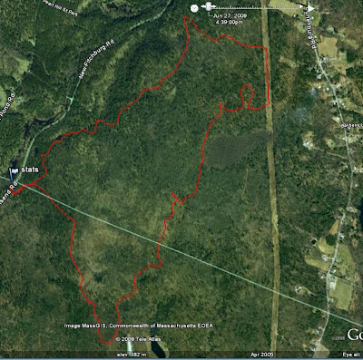
Willard Brook SE. Hadn't run here since last year, and I was pleased to see that it wasn't seriously affected by the ice storm ? just one short trail section was wiped out, and that was easy to get around. I did miss the sharp right-hand turn on the final descent, and realized it when I saw the chicken coops, so I turned right and went through the woods (and through a lot of short laurel) to get back to the trail.
I somehow missed noticing that there was a meet at Ahern today, or I would have gone there instead.
The weather was really nice all day today, though just before I headed out to run, I saw on the radar that there was a line of storms just to my west. And of course I picked a place to run that's west of here. On the drive over, it started sprinkling, and continued to do so during the early part of the run, and then again at the end, but it didn't make it through the canopy. But on the four mile drive home, it was raining hard enough to warrant putting the windshield wipers on the fastest setting. Once I got home, there was even hail, and the power went out for about 2.5 hours. In the wake of this, the network interface on my desktop computer seems to have gone MIA, but I think I have a way to get it up and running again. Unfortunately, it now looks like maybe the power supply has gone wonky as well. Fat lot of good that surge suppressor did.
I brought the GPS with me this time to see how far I was running, and got a good track (see below). Not bad for a $50 piece of hardware and a little programming time. Although I discovered a bug. For hang gliding purposes, I have my program calculate the maximum climb rate. It's indicating that at some point, I gained 157 feet in 12 seconds, and that's simply not feasible.
edit: I looked at the GPS track more closely, and I don't think the problem is in my software. Although the horizontal accuracy of the GPS looks quite good, vertical is a different matter. The vertical component of the track looks pretty plausible when I'm flying and presumably have a great signal, but it appears that it's what suffers when I'm close to the gound and under a tree canopy. Viewing the track from the side, it looks like a roller coaster ride.
I somehow missed noticing that there was a meet at Ahern today, or I would have gone there instead.
The weather was really nice all day today, though just before I headed out to run, I saw on the radar that there was a line of storms just to my west. And of course I picked a place to run that's west of here. On the drive over, it started sprinkling, and continued to do so during the early part of the run, and then again at the end, but it didn't make it through the canopy. But on the four mile drive home, it was raining hard enough to warrant putting the windshield wipers on the fastest setting. Once I got home, there was even hail, and the power went out for about 2.5 hours. In the wake of this, the network interface on my desktop computer seems to have gone MIA, but I think I have a way to get it up and running again. Unfortunately, it now looks like maybe the power supply has gone wonky as well. Fat lot of good that surge suppressor did.
I brought the GPS with me this time to see how far I was running, and got a good track (see below). Not bad for a $50 piece of hardware and a little programming time. Although I discovered a bug. For hang gliding purposes, I have my program calculate the maximum climb rate. It's indicating that at some point, I gained 157 feet in 12 seconds, and that's simply not feasible.
 |
| From misc |
edit: I looked at the GPS track more closely, and I don't think the problem is in my software. Although the horizontal accuracy of the GPS looks quite good, vertical is a different matter. The vertical component of the track looks pretty plausible when I'm flying and presumably have a great signal, but it appears that it's what suffers when I'm close to the gound and under a tree canopy. Viewing the track from the side, it looks like a roller coaster ride.
Friday Jun 26, 2009 #
running 49:09 [3]
Mystery Blazes, cool muggy evening. At least I got out and did something.
Sunday Jun 21, 2009 #
orienteering race 21:30 [3] *** 2.0 km (10:45 / km) +80m 8:57 / km
spiked:10/16c shoes: GoLite SunDragon
SprintA at Ratlum Mtn. Not very smart, left a couple of controls heading in the wrong direction. Would probably have been faster if I had gone a bit slower.
orienteering race 20:40 [3] *** 2.0 km (10:20 / km) +70m 8:48 / km
spiked:12/16c shoes: GoLite SunDragon
SprintB at Ratlum Mtn. Only slightly smarter (or maybe not even). Made it all the way to #6 without going to #5 and had to go back, and in my nettle-addled state I completely missed #15, not realizing it until I finished and noticed that I was short one split on my watch, and had to go to #15 and #16 again.