Training Log Archive: CleverSkyIn the 31 days ending Aug 31, 2014:
| |||||||||||||||||||||||||||||||||||||||||||||||||||||||||||||||||||||||||||||||||||||||||||||||||||||||||
| « | » |
| » now | ||||||||||||||||||||||||||||||||||||||||||||
| Fr | Sa | Su | Mo | Tu | We | Th | Fr | Sa | Su | Mo | Tu | We | Th | Fr | Sa | Su | Mo | Tu | We | Th | Fr | Sa | Su | Mo | Tu | We | Th | Fr | Sa | Su | |||||||||||||||||
Sunday Aug 31, 2014 #
pedaling (road bike) 41:52 [2] 15.66 km (2:40 / km) +162m 2:33 / km
running (trails) 1:39:08 [2] 12.27 km (8:05 / km) +262m 7:18 / km
shoes: GoLite Blaze Lite
About 80 degrees and very humid. The only person I saw was one guy taking a stroll in his neighborhood, and as I loped by, he said something that sounded like "You're a little monkey, huh?". I paused and gave him a puzzled look, and he elaborated and I realized he had said "It's a little muggy, huh?". It was actually pretty gross weather for this sort of thing. Among other things, my stupid Garmin watch went into spazz mode after about 20 minutes, beeping intermittently and not responding to bezel touches. I had to take it off to coax it back to training mode, and promptly locked the bezel so it wouldn't keep doing that. I would have gotten grumpy if this had been much longer, because I lost some calluses on my feet (right foot in particular) at the Rogaine, and those spots are a little tender.
I timed this all very well. It didn't start sprinkling until I was in the car going to pick up the bike, and there wasn't significant rain until after I had gotten ice cream.
*I'm cheating a little on the name here, to keep the 'W' theme going. The sign actually says "Bushy La WB", and a better name for this point would be either Pommogussett Rd. or Rte. 56.
Saturday Aug 30, 2014 #
hiking (sand) 1:00:00 [1] 6.0 km (10:00 / km)
shoes: no
Wednesday Aug 27, 2014 #
chucking wood 1:00:00 [2]
Sunday Aug 24, 2014 #
paddling (kayak) 39:01 [2] 3.42 km (11:25 / km) +1m 11:24 / km
Saturday Aug 23, 2014 #
orienteering race (corn maze) 21:36 [4] *** 2.32 km (9:19 / km) +1m 9:18 / km
spiked:17/18c shoes: Saucony Grid Adapt
orienteering race (corn maze) 7:47 [4] *** 1.16 km (6:42 / km) +1m 6:40 / km
spiked:5/5c shoes: Saucony Grid Adapt
Note
orienteering race (corn maze) 51:35 [4] *** 5.31 km (9:43 / km) +1m 9:43 / km
spiked:25/25c shoes: Saucony Grid Adapt
Friday Aug 22, 2014 #
Note
You have to cut some slack for people with limited experience who are willing to step up and put on a major event. But still, when you're talking about a world championship, the expectations are high, and somebody needs to be responsible. I don't know who that is in this case, maybe not the orgaizers, it might be whoever awarded them the event or didn't give them enough guidance.
1) The model event. The map had hand-written street names on it, in an eclectic style, and with abbreviations. We needed to take Custer Crossing Road, but on the map it looked like Gustav King Road. Good luck if English isn't your first language.
2) Terrain. I had been to the Black Hills only once before, and just observed from the car window because it was rainy, and it looked great. That was years ago, and things have changed, which partly explains why it wasn't so great. Rampant pine bark beetle damage resulting in widespread deadfall is something they presumably knew about when they picked the area. A wet season that made the grass lush, maybe not. The thistles were likely already there, though. So a lot of the terrain was very thick. That isn't so bad as long as you don't put the controls in the nasty areas. But they did. I'm guessing that they decided where to put them from looking at the map, and made no changes after visiting the sites in the field.
2) Map. As PG pointed out, the map was very readable. Unfortunately, it didn't resemble the terrain so much. The contours were okay. The trail network was appalling. There were things I could easily drive my car on that were not mapped, and other things that were on the map that did not exist at all. All of this could surely have been seen in satellite photos. No indication of where it's thick, of course, you don't expect that on this kind of map, but when you hang controls in the bad areas you create bingo situations. Weird scale, too, but whatever. It's also nearly* the largest piece of paper I've ever been given to orienteer on, which was unnecessary. Had I done the layout, the map would have been 23% smaller without looking crowded and still with all of the logos and other design elements.
3) Flag hanging. This was at the level of first time local meet organization. I'm not talking about the fact that some controls were on imaginary features (which they were), but that the control flags were tied directly to the trunks of trees so that they were often collapsed flat, and there was a wide sector in which the reflector would be blocked by the trunk. Huge luck factor depending on what direction you came in from.
4) Hash House. I'm of the opinion that there shouldn't always have to be a well-stocked hash house at a Rogaine, and it might make it a lot more appealing for people to put them on if all they had to supply was hot and cold water all night long and the competitors had to bring the rest themselves. But more is expected at this level, and you have to deliver whatever you advertise. It was pretty disappointing to come in at 4 AM hoping to get some soup or stew or something and only after prodding the crew were we able to get the last bit of chili to mix with some overcooked (that's a good thing in this case) pasta. No soda at all until the separately catered post-race "banquet", so I was glad I had some in the cooler.
5) E-punching and results. My information on this is sketchy and I could be misinformed on some of it. When we finished at 6 AM, we were initially told that there was nobody there who could download our punches. Then a guy showed up who supposedly could, but he turned out to be unable to print our splits - no big deal. Later I heard that there were two controls programmed with the same code and that was going to be difficult to sort out, and that maybe there was a finishing box with the wrong date that was also a problem. Later I heard that they didn't really know what they were doing with the SI stuff at all and that results may be a while in coming. By now it's clear that something went horribly wrong, and it appears that they can't recover the information from the sticks at all, but will have to get it from the retrieved boxes. No awards ceremony, of course.
6) Pre-race briefing. Or as it was called, "indoctrination". This was at 8:30 AM, which I think is much too early for a 24 hour event. It should have consisted of greetings and niceties, but nothing important. And there was in fact too much information given. At one point they mentioned that the briefing would be repeated in Russian in a nearby tent, but they announced that only in English.
7) Bagging of devices. As far as I can tell, this was an absurdity. I don't blame it on the organizers, I think the IRF probably told them what they had to do. The deal was that if you had get it a GPS-capable device that you wanted to bring (e.g. cell phone in case of emergency), you could get it sealed up in an opaque bag. Not too long before the event, they said that the crew couldn't be making distinctions between allowable devices (i.e. trackers with no display that can't be used as navigation aids) and non-allowable ones, so all such devices would need to be bagged, and that meant that there would be no way to change to fresh batteries partway through. I have a non-display tracker that I had been hoping to bring, but a test a couple of weeks before the event showed that it's good for about 10 hours, so I would need two battery changes. 24 hours is a long time to expect for one of these things (even more, actually, because the bagging happened before map distribution, so you really needed 26 hours). Clint and I figured out that we could hook the GPS to his phone auxiliary recharger unit (basically a kind of big USB battery), which would be kind of heavy, but should last long enough. When we got to the meet, we got another piece of news: since some cameras have GPS (not that I can figure how you could utilize the info), and they couldn't be making decisions on which cameras were allowed, all digital cameras were banned (well, you could have them bagged, but that completely defeats the purpose). Rumor was that disposable film cameras were still ok. Annoying, since I had gone to the trouble of picking a small digital camera and rigging up an easy way to carry it. But then at the briefing (and I have to give Rick Emerson credit for this), it was announced that digital cameras were ok as long as they didn't have GPS. Excellent. But then, as far as the bagging goes, they asked if you had anything you needed a bag for, and we just said no. Not like they were searching packs (we didn't even have our packs with us for map distribution), and you could always go back to your tent to grab your illicit iPad or whatever after the start. I just brought the tracker and a couple of spare sets of batteries (which turned out to last a bit less than 8 hours, so I have some data gaps before my scheduled battery changes). But then what was the deal with the bags? In order for this system to make any sense, you'd think that they'd need to have a list of who was issued a bag, and then check the bags at the finish to make sure they were still sealed. Well, when we finished, there was nobody checking any list, and we weren't even asked if we had bags. Maybe they started doing this later, I don't know. But as far as I'm concerned, this system was full of holes. You might think that my opinion is that they shouldn't even have such precautions, but a WRC is one of the places where I think there really is a strong likelihood of people "cheating" by bringing things like this, and I think it would be relatively easy to have it be very effective, especially for less-experienced navigators (some of whom are very strong physically). But what's the solution? I don't have one. It's really easy at this point to bring a small device that can show you where you are on a USGS map, and that's something that that could be really helpful in a Rogaine.
I'm glad to have had the opportunity to orienteer in South Dakota, and as part of an otherwise excellent vacation trip, the shortcomings weren't such a big deal. But the event really kind of sucked, and I would think that people who had flown from far away countries and who had really trained and prepared and were contending would be justified if they were pissed off.
* The two events that had bigger maps were the two Rogaines that I did in Allegany State Park. For those, we were given a multi-use map of the entire park, although in each case the controls were restricted to only about half of the park, and it would have been a cinch to cut half of it off. Some other events also had larger maps, but they were distributed in the form of several overlapping sheets.
Saturday Aug 16, 2014 #
orienteering race (Rogaine) 16:10:42 [2] *** 35.34 km (27:28 / km) +1309m 23:11 / km
spiked:21/23c shoes: GoLite Blaze Lite
One of the first things that happened in the morning was that I encountered Ernst. We knew that Alar was ailing, but it turned out he was too sick to do the race at all, so Ernst asked if he could join Clint and me. Given the circumstances, we seemed like the most logical team, so I said if it was okay with Clint, I was okay with it as long as Ernst took care of the administrative details. And Team Almost Tested Positive became a trio. Here we are with the two other UNO teams, all ready to go.

We came up with a plan pretty quickly, maybe with insufficient consideration. It started out to the south and went various places after that, with some thought to going where the navigation would be comparatively easy for the dark hours, but maybe not a realistic estimate of how fast we'd be going.
#20: 0:19:48. We deviated from our plan right from the get-go. Taking the road to #60 was what we had intended, but Clint and Ernst pointed out that since we were going right past #20, we might as well get it. Very true. We got a little confidence boost from the fact that there were teams screwing up even going to this trivial control. Once we punched, I announced that we had accomplished my primary objective of orienteering in South Dakota.
#60: 0:23:01. This is the only control that I don't have a clear picture of in my mind. Easy enough.
#41: 0:24:54. We were heading directly for the control, then shortly before the drop off the plateau, we deviated to the left. I think it was kind of thick with young evergreens up there. No matter, we knew we had to turn right and contour along until we got to the control. There were a couple of small unmapped reeentrants, then the bigger one was obvious. The control was pretty low, one of the very few that seemed to be a little misplaced. It was basically at the bottom, almost in the meadow. I suppose you could say we lost a small amount of time here.
#85: 0:34:14. Alar had commented before we went out that this control looked pretty ridiculous, and we accordingly took it pretty carefully. We got into the proper reentrant and started following it uphill, and I think we crossed an unmapped road at some point, after which the terrain really broadened out and the reentrant became undetectable. Ran into another team on our way who look like they had gotten mystified. We took advantage of the fact that there were three of us and spread out, but Ernst was right on target and spiked it. No discernable feature.
#100: 0:43:00. We took a little break for Clint to apply tape to his heels (I had taken a break at the start of the previous leg to adjust the tape on my toes) and to eat a bit. We were 100 meters or so from the control, and saw a couple of other teams heading for it. We couldn't see whether they found it or not -- seemed like they were on target, but then we would have expected to see them come past us, and they didn't. The woods on this leg got really thick with a lot of deadfall. We encountered one pretty lost Russian guy who seemed to be asking if the control was thataway, and we gestured and tried to tell him yes, and then he started calling for his teammate. And calling. And as we moved out of earshot, he was still calling. We found a very convenient huge road on the way, which took us almost to the control, we just had to go a couple of hundred meters down the reentrant to get it.
#47: 0:31:59. Straight through some thick young growth to get to the top of the hill, then down the spur.

Ernst and I were looking a little too low, and Clint found the flag higher up, in a passageway through the thick stuff, visible only from close up and from one direction.

#80: 0:22:33. Past the long spur before dropping very steeply into the valley

then we did our first pack drop to get the control, so the GPS track doesn't show the last little bit, since the tracker was in my pack and I never even thought about taking it out.

#35: 0:29:06. Went past Randy Ericksen who was taking pictures on our way down the valley on a cow path. Dropped the packs again to cross the valley and get the flag in thick woods. Clint noted that we were leaving them by a big dead pine, so we could look for that to find them again. Trivial to get back to that spot, though looking across the valley, we could see that the dead pine was anything but unique, and we would have been better off leaving them by the nearby lone live pine.
#28: 0:38:22. Perhaps our biggest mistake of the day was deciding to go to this control at all, because it definitely wasn't worth a measly 20 points. We didn't drop the packs because we were figuring that we might want to go overland to the water stop. We headed up a bit early, as soon as we saw a spot that looked reasonably passable. The woods were insanely thick with deadfall, and we kept getting pushed to the right. Once we topped out on the ridge, we found ourselves in a dense sea of thistles that took a while to push our way through. We knew where we needed to go, but it took forever to get there through more crazy deadfall. The vote was unanimous to go downhill and take the road around, and the descent was every bit as bad as the climb had been.
#39: 0:54:42. Easy enough going once we got to the trail, which was probably higher on the hillside than mapped. Paused at the water stop and chatted with the three young ladies there

then continued to the control, which was pretty straightforward.

#76: 0:37:45. Clint had suggested that we consider skipping this control (which we knew from the intention sheets that that two of the three teams ahead of us had done), but we decided to go for it. Steep climb up from the rail trail, then a little confusion as the other two thought we had gone over the ridge top a little to the right of where we were. I thought the control should be dead ahead or a little to the right, and they thought it was left. They looked left, I looked ahead, nobody found it, then Clint and I went right and found it in the next reentrant. Lost maybe four minutes.
#106: 0:38:52. Over the ridge and down the big reentrant to the rail trail. Well, but there was a big creek in the way. We followed the bank up to the bridge, and could have crossed the creek there, but the going looked awful on the far side of the meadow, so we continued up the trail until near the edge of the private land, then crossed the creek, but had to get a foot wet. The going through the woods along the fence was atrocious. We finally struggled our way through to the reentrant before the control, which was a lovely open meadow. The next-to-last bit was nice, then the final approach to the control was a dense aspen thicket, and we were pretty luck to spike it.
#63: 0:40:24. Up the hill, more ugly woods, and we hit the trail, but it was clear that it wasn't the mapped trail. We took a chance that it would intersect the mapped road, and it did (at the saddle). Stopped at the intersection to reevaluate our plan and decide what to lop off, based on how low the sun was getting. Very nice woods on the way up the spur, turned left, and got another nice spike.

#46: 0:27:05. Just a slog uphill, with the woods getting progressively nastier. Encountered Balter and Vadim near the top. This is where Clint dropped his glasses and accidentally stepped on them, which bent them to the point where they weren't very useful (he had broken the frames on his other glasses before the race, and we had kludged then together with ductape).
#81: 0:56:20. We had #56 on our plan, but decided to skip it. Headed down for the trail, and maybe we found it, but it looked too small to be worth mapping, so we figured the real trail must be a little further. We got into the reentrant, which was a huge meadow, but there was no trace of a trail. None. Perplexed, we went down to the reentrant junction, still no trail, but Ernst said that there was no other place we could possibly be, and he was right. A stop here, where we reorganized our clothing and put on the headlamps, and I changed the batteries in my GPS tracker (more on this in another post), which is why there's a gap up to this point. I started seriously pace counting in the dimming light (which is something I almost never do). Up to where I determined that the side reentrant should be, then up that reentrant, and we encountered a few other teams coming down. It wasn't clear whether they were looking for it or if they had found it, but we kept going until we were just a bit past where I thought we ought to be, and then spotted the reflector -- nice!
#92: 1:25:24. Up the hill, I think it was thick, and we weren't sure if we were going to find the trail or not. I think we were on some intermittent old trail, and fortunately, when it took us to the mapped road, it was big and easy. Around the hairpin we encountered Bash and her partner, and chatted for a minute. We told them about the nonexistent trail ahead, and they mentioned that they had been halfway down to #92 and they saw some guys coming up who said that they had better like poison ivy, because the control was in a knee-deep sea of it, so they turned around and skipped it. We continued up to the trail bend and dropped the packs, then headed into the woods. Started out okay, on a jeep trail, in fact, then we left the trail and woods gradually got thicker. And thicker. And much thicker. And horrible. Deadfall everywhere. Some teams were coming up toward us, looking grim, and one said that the control was unbelievable. It's totally dark at this point, and we're looking for a reentrant. We finally found one, seemed to be going in the right direction, but we had no idea by this point whether we were right or left. It was also full of tangled lumber. I suggested that Ernst look upstream to the left and I could look down to the right, and Clint could sit tight and maintain voice contact with both of us. Down to the right looked terrible. I couldn't imagine that anybody would have hung a control down there. I went a little way, peered down, saw more crud, decided to go a little further, nothing but more junk, then I thought I caught a glimpse of a distant glimmer. I pursued it, and spotted it another couple of times, and worked my way lower until I was sure it was a reflector, than called for the other two to follow me. Clint had been cramping for a while by this point, and it was tough getting down there. What a sucky control. It had a sign-in sheet, and nobody had been there for half an hour. We had waded through a sea of knee-high plants. I had a botanist with me, and he confirmed that they were not poison ivy. We saw no poison ivy all weekend.
#74:1:17:31. Back up through the disgusting tangled nasty stuff. We started out on what looked like elephant tracks out, but they didn't persist. Half an hour to get back to the packs, some of the time on an intermittent jeep road, though the aerial photos indicate that there was a bigger trail off to our west. Paused to eat a bit before continuing, and further evaluated our progress and plans. Around the bend on the road, up the reentrant, ignored the unmapped trail, kept pace counting, up the spur, got to the top, found the reflector.
#103: 0:36:43. Headed straight across the reentrant, went about 15 meters, and stopped short, because I was at the top of a completely vertical cliff that dropped an truly astounding distance. After uttering some obscenities, we worked around it to the left, got down to manageable slopes, crossed the reentrant, and headed for the very top, because it looked like the only possible usable attack point. On the way up, we came to cliffs again, and found this passage in a fin of limestone that afforded a way through.

I think it was in here that Clint commented that the juniper we were trudging through was a nice relief from some of the earlier vegetation. Near the top we encountered another team who I think had been hunting for a while. After a couple of false summits, we got to the real high ground, and went on compass from there. The topography was more complicated than the map showed, and it was also easy to get off of our bearing in the dark. The other team commented that they had already been to where we were, but we pushed a bit further, and just as we were about ready to give up, we spotted the reflector. Sweet!
#55: 0:44:29. We had still been planning on going to #93, but it looked like a lot of distance, and the other team said there was a lot of deadfall, so we decided to skip it. Down into the big reentrant and eastward toward the trail, and it felt like it took forever to get there. The other side of the road was pretty open, and we spotted the reflector from a long way off, though the placement of the control seemed a little weird.
#91: 1:14:26. Down the hill and caught the road at the tip of the hairpin. Up to the water stop where we paused and chatted with the two guys and I was probably kind of grouchy, though I hope in a lighthearted way. Around the road bend, up cattle trails in the reentrant, and started climbing when the pace count indicated to head for the saddle. When we got there, I spotted something weird that looked like maybe a weather balloon, a pile of stuff with aluminized mylar on top. I took a few steps toward it to check it out, but Clint realized it was probably a heap of sleeping Rogainers. Contoured around, and Ernst and Clint were handily in charge for this one.
#90: 0:53:06. We headed down early because it looked like it got steeper to the north. Unfortunately we contoured around a bit too much and hit the trail maybe further to the left than we could have, just past the western hairpin. The tangle at the bottom was among the worst we encountered. Took the trail to the eastern hairpin, up the reentrant, up the spur, no problem.
#30: 0:39:59. Worked our way down to the saddle, where the woods got better and there were some giant unmapped roads. Out along the spur toward the control, keeping good track of where we were, knew we were in the right reentrant, but I never saw the control because I was on the wrong side of the tree. Fortunately, Clint was on the right side of the tree.
#25: 0:19:57. Batteries on the GPS seem to have been giving out again here. We just went generally east, woods were open but still a lot of junk down low. We didn't particularly care whether we found the control, we were just looking for the hash house and we'd get the 20 points if we happened to find the control. If we happened to find elephant tracks we'd follow them. And we did.
HH) 0:06:00 or so. Just down the elephant tracks and through the cold, foggy valley.
At this point we stopped in to eat the very disappointing fare that was available at 4 AM. After pressing them, they found a little leftover chili that I was able to mix with some soggy pasta, and fortunately we had soda in the cooler because there was nothing appealing available to drink. We agreed to take a nap for about an hour to wait for it to get light, then go out with reduced packs for the last six hours, though I noted that Clint was looking really wiped.
After my nap, I looked at the clothes I had been wearing and couldn't bring myself to put any of them back on, so I dug through my luggage and found other stuff to wear. I had moderate blistering on my right foot (little toe and under the ball), so I attempted some draining and bandaging, then climbed out of the tent, where I was greeted by a very unhappy looking Clint. He said that he had hurt his foot too badly to continue, and it was clear from the fact that he was having difficulty even staggering that he was in no shape to do much of anything. This came as something of a relief to me, since I was able to walk, but not without considerable discomfort. So we rounded up Ernst and went over to the finish, where we were one of the first teams to deal with the not-ready-for-prime-time results setup. They were unable to print splits for us, not that we were particularly concerned about that. And back to bed.
I did a pretty good job on the nutritional side of things, continuing to keep my digestive system running, though I was getting pretty sick of the sports drink that I kept forcing down. Tortellini worked well, I had some gels and some M&Ms, and a prewrapped pizza-sandwich thing. Muscles did okay as well, and I was still pretty alert, with the only real problem being the blisters, which were still not as bad as other times. No toenail damage. Clothing worked out fine, I switched to my long-sleeve top at dark but never needed my tights or my ultralightweight jacket. And our navigation was fantastic.
Note that I only took pictures when the woods were nice. Don't get the wrong impression, a lot of the time it was wretched out there.
Friday Aug 15, 2014 #
orienteering (model event) 2:15:00 [1] *** 5.7 km (23:41 / km)
spiked:4/4c shoes: GoLite Blaze Lite
We went 44-39-57-85, starting and ending at the north end of Minnesota Ridge Road. Spiked them all, which is good considering we were walking. On the way out of 39, heading for the start triangle, we came across a huge road on top of the ridge that wasn't on the map. Beyond that road, the woods were impassably thick, so we took the road around. Then the road that 57 was on turned out to be smaller than the unmapped one on the ridge. Hmm, at least we knew what to expect. The white woods on the way to 85 were an open meadow, and the mapped open area at the bottom was pretty slow going due to tall grass.
The woods were not all as nice as the area around #39.

We went to Crazy Horse later, reasonably cool place. I took pictures, but there are plenty of those on the web if you don't know what it looks like.
Thursday Aug 14, 2014 #
Note

Yeah, this is one of the less exciting ones. It brings my meager list to five, as I've also got NH, RI, MA, and CT.
Wednesday Aug 13, 2014 #
Note
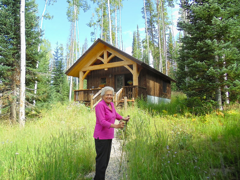
Very old, in fact: Mil's 90th birthday is in about a week. That's her own little cottage in the picture, just a few steps from her daughter's house, deep in the woods. What a wonderful spot for her to be able to relax in. She's slowing down for sure, and has some balance problems, but we had a great time conversing and catching up for a couple of hours. One of the sweetest people I've ever known.
Tuesday Aug 12, 2014 #
hiking 3:51:00 [3] 21.45 km (10:46 / km) +1014m 8:43 / km
shoes: GoLite Blaze Lite

Fine hiking companions
We started out with Gail, who let us go on ahead once it got steep. The hike up was at a stately pace, so so fast that I was hurting. In fact, I felt okay the whole time, in contrast to other times that I've been up high when I've always felt like crap. No other hikers on the trail we used (up from Windy Ridge) until we got up to the saddles, where we eventually saw probably between 30-50 people (and a few dogs). We had gotten an early start in case there were thunderstorms, but the weather was perfect.

Peter, with our destination in the background
Got to the top, and snapped a few pictures

then headed down, quite a bit more quickly. We jogged past the crowd that had started down a little before us, and after I went by the last guy, Peter says it looked like he wasn'f fond of being passed, because he sped up to stay ahead of Peter. I paused at the bottom of a saddle, and they went by and started walking up uphill, where Peter easily got ahead. I caught up, and as I was going by the guy (who looked to be about 30), we had a little conversation.
Him: Wow, do you guys do this a lot?
Me: Not really. This is actually my first 14er, except for the one I did on a bicycle 31 years ago.
Him: (puff puff puff)
Me: And we're from Massachusetts.
(And I thought about adding, "And that guy is 70".)
We made pretty good time coming down, although the flat part at the end, where Peter wanted to keep running half the time, was a killer. The GPS track is actually from Peter's watch, my battery ran out on the way up.
Monday Aug 11, 2014 #
hiking 1:35:54 [2] 5.46 km (17:33 / km) +221m 14:36 / km
shoes: no
A bunch of pictures, these were worth making clickable to biggerize:


Sunday Aug 10, 2014 #
orienteering race 1:06:19 [3] *** 9.32 km (7:07 / km) +113m 6:43 / km
spiked:15/16c shoes: Inov-8 Oroc 280 #1 (blue)
hiking 1:15:00 [3] 6.0 km (12:30 / km) +250m 10:21 / km
shoes: no
If you zoom in on this, you might be able to get a sense of the streaming sand that was blasting me as I took the picture:

Saturday Aug 9, 2014 #
orienteering race 1:25:31 [3] *** 10.68 km (8:00 / km) +223m 7:15 / km
spiked:12/15c shoes: Inov-8 Oroc 280 #1 (blue)
Tuesday Aug 5, 2014 #
pedaling (road bike) 43:20 [3] 17.67 km (2:27 / km)
Monday Aug 4, 2014 #
pedaling (road bike) 46:10 [3] 18.68 km (2:28 / km)
Back in the 1970s, my father was widely known for doing a very crazy thing:riding his bicycle to work. In that modern age, nobody did such a thing, when cars were so readily available (and gas was cheap). How long was this trek? I noted the time as I went past his old place of business, and it took 15 minutes from there.
Sunday Aug 3, 2014 #
running (trails) 2:35:31 [2] 14.9 km (10:26 / km) +481m 8:59 / km
shoes: GoLite Blaze Lite
Redemption Rock, where something important apparently happened back in 1676.

Crow Hill, a popular rock climbing spot where I got my introduction to climbing back in 1978, in the same high school PE class that gave me my first orienteering experience soon after. Nobody climbing today, maybe people don't climb outdoors on real rock any more. In fact, I saw absolutely nobody all day, maybe people don't go outdoors any more.
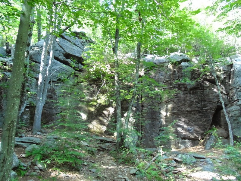
The trail went right up to the top of those cliffs, and along the ridge, providing some nice views.

Evidence of how poorly maintained this section of the trail is: the menus stapled to the trees are over a month out of date!

I'm certain that I did the last section of this with PG a number of years ago, but it didn't look at all familiar. When I was nearly done, I saw for the first time a train on the railroad that runs along the edge of the Baldwin Hill map. Quite a long train, and I was glad that I had an underpass so that I didn't have to wait for it to pass.
No ticks (that I've found so far at least), a few FDFs, mosquitoes were fairly bad, but I was DEETed up and moving, until I was changing my shoes at the end and was sitting down with the DEET all gone by then. And about halfway through, I got stung on the ankle, through a pretty thick sock. Damn, I really hate that. Pretty much stopped hurting after about ten minutes.
Sections I've done on the trail (etc). so far:
Watatic to Windblown
Watatic to Whitmanville
Westminster Rd. to Wachusett
Wachusett to Whitmanville
I wonder how wong this twend will continue.
That's it for running training before my trip west, just a few short bike rides that I need to do this week. I guess I'm in as good shape as I'm going to be.
pedaling (road bike) 32:54 [2] 10.77 km (3:03 / km) +134m 2:53 / km