Training Log Archive: SpikeIn the 7 days ending Jun 22, 2013:
| ||||||||||||||||||||||||||||||||||||||||||||||||||||||||||||||||||
| « | » |
| » now | |||||||||||||
| Su | Mo | Tu | We | Th | Fr | Sa | ||||||||||
Saturday Jun 22, 2013 #
running 45:00 [2]
Out the door by 8 a.m. for a short trail run at Clinton overlook. Kind of humid out there. I saw a dead copperhead on the trail.
1
1
Note
Finally got around to putting the GPS + O' map + chest mount video together from last weekend's sprint event at Ruth Stocksdale Park:
http://www.attackpoint.org/sessiondata.jsp?session...
Note that by rule you were not allowed to run in the forest (also due to jungle like vegetation).
I'd planned to do the same thing for the MTB O' portion, but I forgot to change the GoPro setting from photo to video so all I got was a single snapshot of my bike.
Note
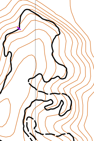
I played around with some lidar data of the area where we did the MTB O' last weekend. I managed to figure out how to get the OCAD map georeferenced in Open Orienteering Mapper. I created a little animation of the comparison (the brown contours are the current PTOC map, green and pink are the contours I generated from the Clay County lidar data):
http://i.picasion.com/pic70/38856e2753debc2997dca8...
The contours from lidar are from the DEM rather than the LAS files. It is a lot easier to work with the DEMs from Clay County because they are much smaller than the LAS files and they seem to have enough detail to generate decent contours. You can't get the vegetation info or trees in the forest from the DEM, but it is enough for now.
Friday Jun 21, 2013 #
cycling 45:00 [1]
Work commute.
running 20:00 [2]
Slow and sweaty jog from home. I explored the in-progress map of Holcom Park.
1
1
Thursday Jun 20, 2013 #
cycling 45:00 [3]
Work commute.
While Mary ran Ulrik's Hill, I stayed at home and played around with the map for Sunday's event.
1
While Mary ran Ulrik's Hill, I stayed at home and played around with the map for Sunday's event.
1
Wednesday Jun 19, 2013 #
cycling 45:00 [1]
Work commute. Feeling much better today than I was yesterday.
1
1
Tuesday Jun 18, 2013 #
cycling 45:00 [1]
Work commute. Some rain for the trip home.
1
1
other 5:00 [1]
A little stronger.
I feel sort of beat up. I wonder if it is from falling off my MTB on Saturday.
I feel sort of beat up. I wonder if it is from falling off my MTB on Saturday.
Monday Jun 17, 2013 #
cycling 45:00 [1]
Work commute.
Strange. My left leg has been a bit sore all day.
I spent some time reading about the European MTB O' champs in Poland. I'm impressed that the organizers managed to come up with a new venue in a day.
1
Strange. My left leg has been a bit sore all day.
I spent some time reading about the European MTB O' champs in Poland. I'm impressed that the organizers managed to come up with a new venue in a day.
1
Sunday Jun 16, 2013 #
running 25:00 [2]
Some easy jogging on West Campus making notes about trees that have been cut down and need to be removed from the map.
1
1
other 5:00 [1]
Just a little bit stronger.