Training Log Archive: simonIn the 7 days ending May 18, 2008:
| |||||||||||||||||||||||||||||||||||||||||||||||||||||
| « | » |
| » now | ||||||||||
| Mo | Tu | We | Th | Fr | Sa | Su | |||||||
Sunday May 18, 2008 #
Note
Back from the NCOF. I have to figure a number of personal things going wrong. Tomorrow - there will be blood - on this log.
Orienteering race (Long) 2:19:57 [3] **** 10.4 km (13:27 / km)
16c shoes: Falcon VJ
GPS: 15.9km (8:49) +470m
http://trail.motionbased.com/trail/activity/570227...
Worst... single leg mistake... ever.
It is the story of a careful race, getting better and better, and suddenly plunging in total nightmare.
Well at first not so good with a mistake on first control in diffuse contours, on a 1:15000 scale which changes the distance feeling. Second was a cautious approach, 5th saw a small bubble, 6th a bad route choice, too far on the left over the top, rocky and slow ground, 9th another small bubbles (but the map does not look quite right in this area) as well as 11th in a rather diffuse area (stopped 30s to help relocate another competitor, even as I was having my own mistake).
To this point I was rather happy with my race, having good feelings and confidence, in particular as it seemed like I catched some people and having a good control on what I was doing. I was past the first half of the course, and the second half promised to be interesting and physical, especially 12 and 13th with complete off-trail route choices.
And then... The Big One:
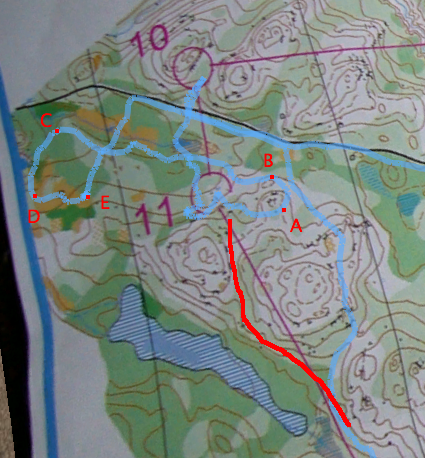
It requires a bit of explanation: the red line is my planned route choice from the 11th control, through the pass and then along the big marsh. Blue is my actual trace as recorded by my GPS (without which I would still be puzzled by my mystake).
It is rather obvious that I soon started to deviate from my bearing but, for some reason, I failed to notice it (also the visibily was low in the area, with new foliage, so I didn't have a clear sight of my surroundings). As I passed the small hill in A, I noticed the descending slope and turned left, thinking I was after the pass, turning along the marsh's valley. Until B point, it is not clear if and why I didn't notice something wrong with my bearing, but then I continue and worsen my beginning mistake WITH AN INVERSE BEARING (a '180' if you like). And I kept happily going down the slope in low visibility, finally coming upon the marsh I had already crossed, but which I mistook for another on my planned route (further south west).
I was happily running the marsh for 5 minutes until C, where the big left turn in the marsh (it looked more like a marsh than the small river on the map) bugged me for the first time. As in any big mistake I kind of denied it, thinking of a small distortion in map drawing. Then I stumbled upon a big patch of yellow in D and there, there was a problem: there wasn't any patch of yellow on my route choice. I tried to take a bearing but it was even more puzzling: the direction was completely different of what I thought it should be. It became rather obvious I have made a big mistake, except suddenly I have no idea where I was, where I made it (since until C everything seems fine), and which feature I could use to relocate since I couldnt even see a yellow patch on my map in the area I was looking at (I had no idea I made a mistake so early in my navigation) - I even thought I had made a map exit (well, almost from my gps trace). I stood at E point, trying to figure out where I was, and what was the best course of action from there. After a good 4 (!) minutes standing, I figured in desperation I should try to hit the big trail north. Hitting it was a big relief and kind of confirm my guess of where I was, even if I was unable to understand my mistake at the time. After that I ran up the trail a bit just to let it go and resume my route choice at the trail turn/yellow patch.
Leg time: 34:47 minutes! Time lost in mistake (including trail section): 20 minutes (and 2km)
After this mistake of course the race was not the same. I was at 1h45 of race when I finally found the 12th control, with lots of mental and physical energy consumed by the mistake. In general the 1h30/1h45 is kind of a physiological barrier after which I found it difficult to have some kind of energy and simply tried to keep enough concentration to avoid big mistakes. So the end of the race was tough, slow but rather event-free.
Apart from this one big mistake, I should say that I enjoyed very much the race, the Gatineau park, a fun terrain, as well as the people there. Also it is funny to see a small organization with so good contenders (after all it was a selection race for the Canadian team).
http://trail.motionbased.com/trail/activity/570227...
Worst... single leg mistake... ever.
It is the story of a careful race, getting better and better, and suddenly plunging in total nightmare.
Well at first not so good with a mistake on first control in diffuse contours, on a 1:15000 scale which changes the distance feeling. Second was a cautious approach, 5th saw a small bubble, 6th a bad route choice, too far on the left over the top, rocky and slow ground, 9th another small bubbles (but the map does not look quite right in this area) as well as 11th in a rather diffuse area (stopped 30s to help relocate another competitor, even as I was having my own mistake).
To this point I was rather happy with my race, having good feelings and confidence, in particular as it seemed like I catched some people and having a good control on what I was doing. I was past the first half of the course, and the second half promised to be interesting and physical, especially 12 and 13th with complete off-trail route choices.
And then... The Big One:
It requires a bit of explanation: the red line is my planned route choice from the 11th control, through the pass and then along the big marsh. Blue is my actual trace as recorded by my GPS (without which I would still be puzzled by my mystake).
It is rather obvious that I soon started to deviate from my bearing but, for some reason, I failed to notice it (also the visibily was low in the area, with new foliage, so I didn't have a clear sight of my surroundings). As I passed the small hill in A, I noticed the descending slope and turned left, thinking I was after the pass, turning along the marsh's valley. Until B point, it is not clear if and why I didn't notice something wrong with my bearing, but then I continue and worsen my beginning mistake WITH AN INVERSE BEARING (a '180' if you like). And I kept happily going down the slope in low visibility, finally coming upon the marsh I had already crossed, but which I mistook for another on my planned route (further south west).
I was happily running the marsh for 5 minutes until C, where the big left turn in the marsh (it looked more like a marsh than the small river on the map) bugged me for the first time. As in any big mistake I kind of denied it, thinking of a small distortion in map drawing. Then I stumbled upon a big patch of yellow in D and there, there was a problem: there wasn't any patch of yellow on my route choice. I tried to take a bearing but it was even more puzzling: the direction was completely different of what I thought it should be. It became rather obvious I have made a big mistake, except suddenly I have no idea where I was, where I made it (since until C everything seems fine), and which feature I could use to relocate since I couldnt even see a yellow patch on my map in the area I was looking at (I had no idea I made a mistake so early in my navigation) - I even thought I had made a map exit (well, almost from my gps trace). I stood at E point, trying to figure out where I was, and what was the best course of action from there. After a good 4 (!) minutes standing, I figured in desperation I should try to hit the big trail north. Hitting it was a big relief and kind of confirm my guess of where I was, even if I was unable to understand my mistake at the time. After that I ran up the trail a bit just to let it go and resume my route choice at the trail turn/yellow patch.
Leg time: 34:47 minutes! Time lost in mistake (including trail section): 20 minutes (and 2km)
After this mistake of course the race was not the same. I was at 1h45 of race when I finally found the 12th control, with lots of mental and physical energy consumed by the mistake. In general the 1h30/1h45 is kind of a physiological barrier after which I found it difficult to have some kind of energy and simply tried to keep enough concentration to avoid big mistakes. So the end of the race was tough, slow but rather event-free.
Apart from this one big mistake, I should say that I enjoyed very much the race, the Gatineau park, a fun terrain, as well as the people there. Also it is funny to see a small organization with so good contenders (after all it was a selection race for the Canadian team).
C • wow 1
Running warm up/down 30:00 [2] 3.0 km (10:00 / km)
shoes: Falcon VJ
Warm up for the long distance, around...
Saturday May 17, 2008 #
Orienteering race (Middle) 55:06 *** 4.0 km (13:47 / km)
18c shoes: Falcon VJ
GPS: 5.8km, +120m
Worst... race... ever...
Instead of spiked controls, speaking of boomed controls is much more eloquent: 4 major booms on the first 8 controls. After a first nice and rather easy control, I boomed at 2nd, 4th, 6th, and 8th controls, each time getting worse and worse, to the point where I would stand in the forest, completely lost, without a single clue of where I lost map contact, and doubting everything, including the map and the compass.
Not sure exactly what leads to this disaster, except perhaps a combination of too high self-confidence after past weeks success, very low visibility in forest due to new foliage, which I am not really accustomed to, and perhaps fatigue of the past week of work. During the race it was clearly a gross failure to recognize my mistakes and to adapt my o'technique to the terrain and map at hand. Plus, didnt have much of pleasure with the terrain, which I found too green, and the course layout, which I found angular, adding too much "accidental" complexity to the "essential" complexity of the terrain (to speak in SE terms)
After the 8th control I pretty much jogged around the course, and still managed to do some slight mistakes.
http://trail.motionbased.com/trail/activity/570227...
Orienteering race (Sprint) 16:54 [4] *** 2.3 km (7:21 / km)
16c shoes: Falcon VJ
GPS: 2.55km (6:39) +80m
After the middle disaster, running the sprint was rather a formality, especially since it was the same terrain with a scale-up map. Notable difference in weather though, because we ran under a cold "douche" after the hot sun of the morning.
My only goal was then to have a clean race, and perhaps to redeem a bit of confidence. I almost blow it up on the first control, then it was an ok race. I just took it slowly in the forest, where I finally managed to feel in control - legs felt quite powerless too. Not a bad race but clearly not a strong one, as there was much more people in front of me than behind.
http://trail.motionbased.com/trail/activity/570227...
Running warm up/down 40:00 [2] 4.0 km (10:00 / km)
shoes: Falcon VJ
Total warm up for both races, around...
Wednesday May 14, 2008 #
Orienteering (Contours) 50:04 [4] **** 7.0 km (7:09 / km)
14c shoes: MT800 New Balance
GPS: 8.27km at 6:03, +320m
http://trail.motionbased.com/trail/activity/566999...
Nice training organized by Thomas on the Mount Royal (actually the first training in many years I think). He draws some courses, including one on contours only map (exlcuding even cliffs!). Good training, except that I am beginning to know the mountain very well, so most of the time one eye on the map was sufficient to know where the control stands and how to get there. Actually getting there was not sufficient as you still have to find the red ribbon. It still is a very nice feeling to have this fast speed sensation in forest while having an almost flawless orienteering.
And the training was followed by a nice barbecue. Thomas and his friends may have launched a new tendency in Ramblers.