Training Log Archive: bigginsIn the 31 days ending Aug 31, 2016:
| |||||||||||||||||||||||||||||||||||||||||||||||||||||||||||||||||||||||||||||||||||||||||||||||||||||||||||||||||||||||||||||||||||
| « | » |
| » now | |||||||||||||||||||||||||||||||||||||||||||||||||||||
| Mo | Tu | We | Th | Fr | Sa | Su | Mo | Tu | We | Th | Fr | Sa | Su | Mo | Tu | We | Th | Fr | Sa | Su | Mo | Tu | We | Th | Fr | Sa | Su | Mo | Tu | We | ||||||||||||||||||||||||||
Wednesday Aug 31, 2016 #
run 3:16:02 [3] 15.83 mi (12:23 / mi) +1016m 10:20 / mi
Tuesday Aug 30, 2016 #
road bike 57:17 [3] 13.8 mi (14.5 mph) +266m
Monday Aug 29, 2016 #
road bike 1:05:49 [3] 16.56 mi (15.1 mph) +305m
mtn bike 1:03:38 [3] 6.79 mi (6.4 mph) +199m
Thursday Aug 25, 2016 #
orienteering 34:25 [3] 2.77 km (12:26 / km) +122m 10:12 / km
12c
Wednesday Aug 24, 2016 #
run 3:30:35 [3] 14.49 mi (14:32 / mi) +1266m 11:26 / mi
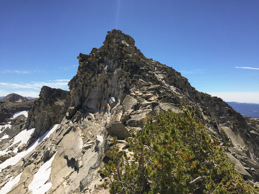
Figured it'd be fun to run back around the south side of the lake, but it turns out that all the cool mini ridge geostuff that made aloha lakes doesn't stop at the water line, so that side was death by a million 1-meter cliffs and was way slower than the far side.
Got back to the trail and started jogging back, and that's when things started going wrong. I still had water left, but it wasn't really doing anything, just making me feel gross. By the time I was at the west end of Echo Lakes I had to stop a couple times, and finally just miserably hiked in the last three miles or so with some epic cramping. I assume it was a combination of heat and water and salt and unacclimatized altitude (silly sea level trips), and probably also throwing in a 10k' peak in the middle of my perfectly good long run.
hiking 2:42:32 [3] 5.19 mi (31:19 / mi)
Tuesday Aug 23, 2016 #
mtn bike 54:46 [3] 6.74 mi (7.4 mph) +153m
Monday Aug 22, 2016 #
road bike 1:39:55 [3] 26.15 mi (15.7 mph) +417m
Saturday Aug 20, 2016 #
orienteering race 16:05 [4] 3.49 km (4:36 / km) +8m 4:33 / km
orienteering race 10:48 [4] 2.24 km (4:50 / km) +6m 4:46 / km
Friday Aug 19, 2016 #
run 9:04 [3] 0.91 mi (9:56 / mi) +8m 9:40 / mi
Thursday Aug 18, 2016 #
run 52:22 [3] 6.24 mi (8:24 / mi) +30m 8:16 / mi
mapping 2:00:00 [0]
Tuesday Aug 16, 2016 #
swim 1 [3] 0.42 km (2 / km) +1242m / km
Monday Aug 15, 2016 #
run 51:26 [3] 6.44 mi (7:59 / mi) +29m 7:53 / mi
run 38:45 [3] 4.04 mi (9:35 / mi) +12m 9:30 / mi
swim 1 [3] 0.24 km (4 / km)
Saturday Aug 13, 2016 #
run 51:21 [3] 6.51 mi (7:53 / mi) +48m 7:43 / mi
Thursday Aug 11, 2016 #
run 53:16 [3] 5.53 mi (9:38 / mi) +30m 9:28 / mi
Wednesday Aug 10, 2016 #
swim 1 [3] 0.21 km (5 / km)
Tuesday Aug 9, 2016 #
run 1:10:06 [3] 8.1 mi (8:39 / mi) +48m 8:30 / mi
Sunday Aug 7, 2016 #
run 59:57 [3] 6.65 mi (9:01 / mi) +31m 8:53 / mi
Friday Aug 5, 2016 #
run 1:11:46 [3] 8.06 mi (8:54 / mi) +44m 8:46 / mi
Wednesday Aug 3, 2016 #
run 34:08 [3] 3.89 mi (8:47 / mi) +9m 8:43 / mi
Monday Aug 1, 2016 #
run 2:57 [3] 0.28 mi (10:30 / mi)
run 5:00 [3] 0.56 mi (8:56 / mi)
orienteering 22:01 [3] 4.33 km (5:05 / km) +8m 5:02 / km
orienteering 14:03 [3] 2.96 km (4:45 / km) +1m 4:44 / km
swim 1:20 [3] 0.1 km (13:45 / km) +12m 8:34 / km