Training Log Archive: TheInvisibleLogIn the 7 days ending Jul 1, 2018:
| |||||||||||||||||||||||||||||||||||||||||||||||||||||||||||||||||||||||||||||||
| « | » |
| » now | ||||||||||
| Mo | Tu | We | Th | Fr | Sa | Su | |||||||
Sunday Jul 1, 2018 #
Back, core and achilles 35:00 [1]
Saturday Jun 30, 2018 #
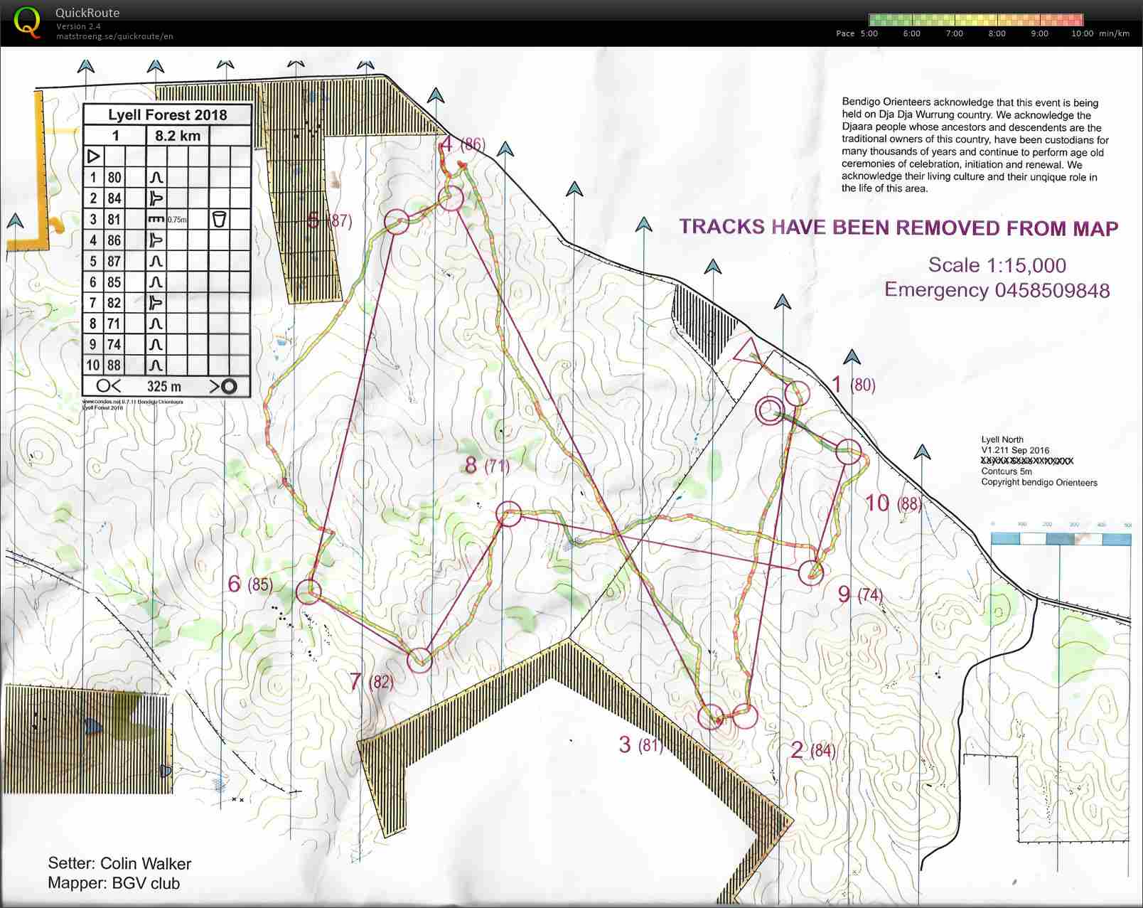
Real Orienteering race (Lyell Forest North) 1:17:26 [3] **** 9.61 km (8:03 / km) +170m 7:24 / km
ahr:136 max:160 spiked:7/10c shoes: Salamon Speedcross 4 blue No 2
Lyell Forest map with all tracks removed. Made a nondescript area into a very interesting area. I chose course 1 because it looked clearly the best course, with three 1+k legs and one 2+k leg. Its a treat to face legs of this length with no tracks. Of course, this meant the course was over 8 ks. I wasn't sure I was up to this and after 6ks my pace slowed noticeably.
Spiked the first 1k leg, appreciating the new Str8 compass. Everything was looking hunky dory on the 2k leg, until the control wasn't where I expected it. I was one mini spur to the right. Had to relocate and lost 5.30. It wasn't just me. Ted was one spur to the left and I am not sure what Steve Bird was up to. Took an overly conservative route on the next long leg, and lost time to be accurate. In retrospect should have gone straight over the hill. Thought the troubles were all over, but came up a gully where I expected 9 to be to instead find the two Goonans in conference who then declared to me that the control was missing. I thought this was an unlikely conclusion and told them so. I had seen Ted heading off down a track a few moments earlier (and down the hill). Knowing the course setter I suspected he would have placed the control on a track as part of a novice course. I headed off to the right and there was the control on the track. My discovery was followed by the two Goonans and Ted descending on the control soon after.
Lost 1.30 on that control. A slight wobble followed on 10 (30 seconds). All in all an excellent experience. The day has left me with a few tasks-
1. A new assembly area was used which I will need to add to the club map site, with the riding instructions that people should park on Czar road and the private track should be marked as out of parking bounds. Landholder was unimpressed.
2. Will add trackless versions of the OCAD file to the map web site for the maps in this area.
3. Will be on the lookout for lidar to this area. Its clear that some of the gully shapes are questionable and the map is clearly beset by some photogrametric distortions.
Thursday Jun 28, 2018 #
Walking 2:15:00 [1] 9.0 km (15:00 / km)
Mapping for upcoming event.
Tuesday Jun 26, 2018 #
Walking 4:00:00 [2] 8.5 km (28:14 / km) +500m 21:49 / km
Snow shoeing. Sort of walking. Mt Torbreck.
C • Why? 3
Monday Jun 25, 2018 #
Running 30:00 [3] 4.5 km (6:40 / km) +55m 6:17 / km
shoes: Salamon Speedcross 4 blue No 2
Walking 1:30:00 [3] 6.6 km (13:38 / km) +30m 13:20 / km
shoes: Salamon Speedcross 4 blue No 2
Mapping. Or should I say... remapping. Prescribed burn recovery.